Pakistan Elevation Map — Topographic & 3D Terrain
Explore the terrain of Pakistan in interactive 3D, built from Copernicus GLO-30 satellite elevation data — from the Arabian Sea across the Indus plain to some of the highest mountains on Earth. Drag to rotate, scroll to zoom, and tap any point to read its elevation.
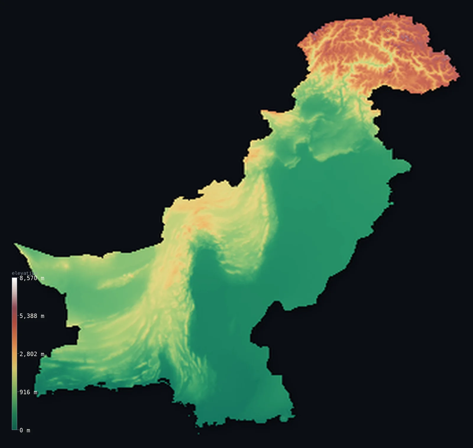
Pakistan’s highest point is K2 (Mount Godwin-Austen) at 28,251 ft (8,611 m); its lowest is Arabian Sea at 0 ft (0 m); the mean elevation is 3,294 ft (1,004 m).
Pakistan is built around one great river. The Indus runs the length of the country, from the Karakoram in the north to the Arabian Sea in the south — and around it the land climbs from flat delta and plain to some of the highest mountains on Earth. The mapped territory reaches 28,251 ft (8,611 m) at K2, the world's second-highest peak — one of five summits above 8,000 m within the boundary, where the Karakoram, the Himalaya, and the Hindu Kush meet. To the west lie the dry plateaus and ranges of Balochistan; and about half the country, for all its heights, lies below 1,677 ft (511 m) — the great plain of the Indus.
- Highest point📚
- 28,251 ft8,611 m
- Pakistan's highest point is K2 at 28,251 ft (8,611 m), in the Karakoram range in the north — the second-highest mountain on Earth after Everest, and the highest point of the territory this map covers. It lies in Gilgit-Baltistan, part of the wider Kashmir region: administered by Pakistan and claimed by India. It is one of five peaks above 8,000 m within the mapped boundary, more than any country but Nepal and China.
- Lowest point📚
- 0 ft0 m
- Pakistan's lowest point is the Arabian Sea at sea level, along the southern coast of Sindh and Balochistan — where the Indus, after crossing the length of the country, reaches the sea through a broad delta.
- Mean elevation⚙
- 3,294 ft1,004 m
- Computed from the GLO-30 model, Pakistan's mean elevation is 3,294 ft (1,004 m) — a middling figure that averages extremes: a vast low river plain and coastal lowland in the south and east, and some of the highest mountains in the world crowded into the north.
- Median elevation⚙
- 1,677 ft511 m
- Half of Pakistan lies below 1,677 ft (511 m) — well below the mean, the mark of a country whose bulk is the low Indus plain and the coastal south, with the enormous heights of the north lifting the average far above the typical ground.
- Elevation range📚
- 28,251 ft8,611 m
- From the Arabian Sea to the summit of K2, Pakistan spans about 28,250 ft — one of the greatest elevation ranges of any country, from sea-level delta to the world's second-highest peak, nearly all of the height gained in the northern mountains.
- Above 1,000 m (3,281 ft)⚙
- 33%
- About 33% of Pakistan rises above 1,000 m (3,281 ft) — the northern mountains and the western plateaus of Balochistan and the tribal belt. The other half is the low Indus plain and the southern coast.
- Above 2,000 m (6,562 ft)⚙
- 15%
- Roughly 15% of Pakistan stands above 2,000 m (6,562 ft) — the high country of the north, where the Karakoram, Himalaya, and Hindu Kush carry glaciers and peaks among the tallest anywhere, and the higher reaches of the Balochistan ranges.
- Official area📚
- 340,508 mi²881,913 km²
- Pakistan covers about 340,500 sq mi (881,913 sq km) — from the Arabian Sea north to the Karakoram, built around the Indus river, which runs the length of the country from the northern mountains to the southern delta.
- Forest cover📚
- 4.8%
- About 4.8% of Pakistan is forested — a small share, concentrated in the northern mountains where moisture reaches the slopes; the Indus plain is farmland and the west and south are dry plateau, desert, and scrub.
Highest and lowest points
Pakistan's highest point is K2, 28,251 ft (8,611 m), in the Karakoram — the second-highest mountain on Earth after Everest, and by repute the hardest of the eight-thousanders to climb. It stands in Gilgit-Baltistan, part of the greater Kashmir region administered by Pakistan and claimed by India; this map follows the boundary drawn by geoBoundaries, and reports the terrain within it without taking a position on the dispute. K2 is one of five peaks above 8,000 m inside that boundary — with Nanga Parbat, Gasherbrum I, Gasherbrum II, and Broad Peak — a concentration of extreme height matched only by Nepal and China. Nearby stands Tirich Mir (7,708 m), the highest peak of the Hindu Kush.
source ↗Pakistan's lowest point is the Arabian Sea at sea level, along the southern coast. Here the Indus, after flowing some 3,000 km from the mountains of the north across the whole length of the country, spreads into a wide delta of distributaries and mangrove before reaching the sea. The coastal lowland of Sindh and Balochistan is hot, dry, and flat — the low end of a country that climbs, in the north, higher than almost any other.
source ↗Pakistan at a glance
K2 (8,611 m), in the Pakistani-administered Karakoram, is the second-highest mountain on Earth and widely considered the most difficult of the eight-thousanders to climb.
source ↗Five of the world's fourteen peaks above 8,000 m stand within Pakistan's mapped boundary — K2, Nanga Parbat, Gasherbrum I, Gasherbrum II, and Broad Peak — a concentration matched only by Nepal and China.
source ↗Three of the world's great mountain ranges — the Karakoram, the Himalaya, and the Hindu Kush — meet in northern Pakistan, near Gilgit.
source ↗The Indus river runs the entire length of Pakistan, from the northern mountains to the Arabian Sea, watering the plain where most of the population lives.
source ↗Tirich Mir (7,708 m), in the north, is the highest peak of the entire Hindu Kush range.
source ↗The Karakoram holds some of the longest glaciers outside the polar regions, including the Baltoro and Siachen, feeding the Indus system.
source ↗The Indus plain is watered by the five rivers of the Punjab, whose name means 'five waters'.
source ↗
Elevation profile of Pakistan
The largest share of land, 67%, falls in the 0–1,000 m band, with the land split almost evenly above and below 500 m (1,640 ft).
- below 500 m (1,640 ft)50%
- 500–1,000 m17%
- 1,000–2,000 m18%
- above 2,000 m (6,562 ft)15%
Highest peaks of Pakistan
| Peak | Elevation | Range | Note |
|---|---|---|---|
| K2 (Mount Godwin-Austen)↗ | 28,251 ft8,611 m | Karakoram (north, China border) | Highest point of Pakistan and the second-highest mountain on Earth, a border summit shared with China. |
| Nanga Parbat↗ | 26,660 ft8,126 m | Himalaya (north, Diamer) | The ninth-highest mountain on Earth and the western anchor of the Himalaya, the 'Killer Mountain'. |
| Gasherbrum I (Hidden Peak)↗ | 26,509 ft8,080 m | Karakoram (north, China border) | The eleventh-highest mountain on Earth, in the Gasherbrum massif near Concordia. |
| Broad Peak↗ | 26,414 ft8,051 m | Karakoram (north, China border) | The twelfth-highest mountain on Earth, close to K2 above the Baltoro Glacier. |
| Gasherbrum II↗ | 26,362 ft8,035 m | Karakoram (north, China border) | The thirteenth-highest mountain on Earth, in the Gasherbrum group above the Baltoro Glacier near Concordia — the fifth of Pakistan's peaks above 8,000 m, a border summit shared with China. |
| Tirich Mir↗ | 25,289 ft7,708 m | Hindu Kush (northwest) | The highest peak of the Hindu Kush, towering over Chitral in the northwest. |
The northern mountains, the Indus plain, and the western deserts
The northern mountains
Where the Karakoram, Himalaya, and Hindu Kush converge, northern Pakistan holds some of the highest and most glaciated terrain on Earth — K2 and four more eight-thousanders, the great Baltoro and Siachen glaciers, and deep valleys like Hunza. It lies largely in Gilgit-Baltistan and Azad Kashmir, part of the disputed Kashmir region administered by Pakistan.
The Indus plain
The heart of the country — the broad, flat, intensively farmed plain of the Indus and its tributaries, running from the northern foothills down through Punjab and Sindh to the delta. Low and fertile, it holds most of Pakistan's people and cities, from Lahore to Karachi.
The Balochistan plateau and the west
West of the Indus rises the dry, rugged plateau of Balochistan — arid ranges, desert basins, and sparse population, reaching toward the borders with Iran and Afghanistan. It is the largest province by area and the emptiest, a land of stony highland and desert.
The deserts and the coast
In the southeast lies the Thar Desert along the Indian border; along the south, the hot, dry Makran and Sindh coast on the Arabian Sea, where the Indus meets the sea through its delta. The low, arid southern edge of the country.
How to read this map
Color shows elevation; the raised relief shows real terrain. On this map Pakistan reads as a country of extremes — a mass of white-and-brown high mountains crowded into the north, the broad green ribbon of the Indus plain running down the centre, and dry plateau and desert in the west and southeast, falling to the coast.
The 3D relief is the actual GLO-30 elevation data, exaggerated vertically so the northern peaks and the plain both show; the ×N relief slider controls how much. Tap anywhere to read that point's exact elevation.
City elevations in Pakistan
Pakistan's cities line the Indus plain — Karachi on the southern coast, Lahore, Faisalabad, Multan, and Rawalpindi across Punjab, with Islamabad at the plain's northern edge below the mountains, and Quetta up on the Balochistan plateau. Most sit low on the plain.
| City | Population | Elevation |
|---|---|---|
| Lahoreon the Punjab plain near the Indian border ↗ | 13,004,135 | 722 ft220 m |
| Karachithe largest city, on the Arabian Sea coast in the south, near the Indus delta ↗ | 11,624,219 | 30 ft9 m |
| Peshawar | 4,758,762 | 1,125 ft343 m |
| Faisalabad | 3,800,193 | 614 ft187 m |
| Rawalpindi | 3,357,612 | 1,667 ft508 m |
| Multan | 2,169,915 | 420 ft128 m |
| Hyderabad | 1,921,275 | 89 ft27 m |
| Quettaon the Balochistan plateau in the west, the country's highest major city ↗ | 1,565,546 | 5,528 ft1,685 m |
| Bannu | 1,357,890 | 1,247 ft380 m |
| Islamabadcapitalthe capital, at the northern edge of the Indus plain below the Margalla Hills ↗ | 601,600 | 1,909 ft582 m |
Elevation sampled at each city centre from the Copernicus GLO-30 model. Cities and population from GeoNames (CC-BY 4.0).
Pakistan in comparison
Pakistan's terrain rises 28,251 ft (8,611 m) from sea level to K2 (Mount Godwin-Austen) — about 97% of the height of Mount Everest, the world's highest point at 29,032 ft (8,849 m).
- India's mean elevation is 2,306 ft — 988 ft lower; its high point, K2 (Godwin-Austen), reaches 28,251 ft (8,611 m), 0 ft above. India elevation map →
- Afghanistan's mean elevation is 5,906 ft — 2,612 ft higher; its high point, Noshaq, reaches 24,580 ft (7,492 m), 3,671 ft below. Afghanistan elevation map →
- China's mean elevation is 6,014 ft — 2,720 ft higher; its high point, Mount Everest (Qomolangma), reaches 29,032 ft (8,849 m), 781 ft above. China elevation map →
Frequently asked questions
What is the highest point in Pakistan?
- K2, 28,251 ft (8,611 m), in the Karakoram — the second-highest mountain on Earth. It lies in Gilgit-Baltistan, part of the Kashmir region administered by Pakistan and claimed by India.
What is the lowest point in Pakistan?
- The Arabian Sea at sea level, along the southern coast, where the Indus reaches the sea through its delta.
What is the average elevation of Pakistan?
- Computed from the Copernicus GLO-30 model, the area-weighted mean is 3,294 ft (1,004 m) — a figure averaging the low Indus plain and coast against the extreme heights of the northern mountains.
How many of the world's highest peaks are in Pakistan?
- Five of the fourteen mountains above 8,000 m stand within the mapped boundary — K2, Nanga Parbat, Gasherbrum I, Gasherbrum II, and Broad Peak — a concentration matched only by Nepal and China, where the Karakoram, Himalaya, and Hindu Kush meet in the north.
Which boundary does this map use for Pakistan?
- It follows the outline drawn by geoBoundaries, which includes Gilgit-Baltistan and Pakistani-administered Kashmir — regions administered by Pakistan and claimed by India. The map reports the terrain within that boundary without taking a position on the dispute.
Is this a topographic, relief, contour, or elevation map of Pakistan?
- They describe the same thing — terrain height. This page renders the country's actual elevation surface in interactive 3D and reports the statistics computed from it.
About this map
The terrain is rendered from the Copernicus GLO-30 digital elevation model (ESA), masked to the PAK-ADM0 boundary from geoBoundaries (gbOpen). Elevation statistics are computed directly from the model; peak names and researched facts are sourced and cited. See the methodology for the full pipeline.
Our area-weighted mean, computed from the Copernicus GLO-30 model, is 3,294 ft (1,004 m); the figure commonly cited elsewhere is 2,953 ft (900 m) (CIA World Factbook). The low Indus plain fills the south and centre, while the Karakoram, Himalaya, and Hindu Kush crowd the north — so the computed mean averages a country of extremes. The page reports the area-weighted mean computed from the Copernicus GLO-30 model over the rendered territory.
Surveyed national figures: official area · forest cover · high point.
Rendered from Copernicus GLO-30 (ESA, 2021 release), boundaries from geoBoundaries. Generated 2026-06-26.
Bordering countries · 4
Pakistan shares a land border with these countries — open any one to compare its terrain and highest point.