Luxembourg Elevation Map — Topographic & 3D Terrain
Explore the terrain of Luxembourg in interactive 3D, built from Copernicus GLO-30 satellite elevation data — a small country of two halves, the wooded Ardennes north and the rolling Gutland south. Drag to rotate, scroll to zoom, and tap any point to read its elevation.
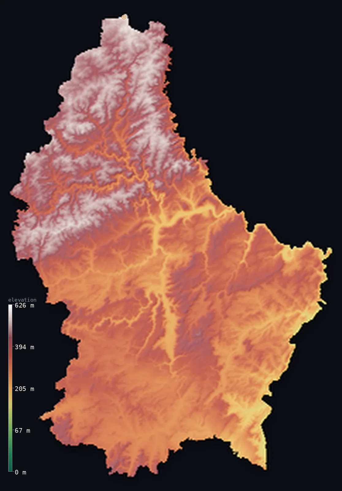
Luxembourg’s highest point is Kneiff at 1,837 ft (560 m); its lowest is Moselle River (at Wasserbillig) at 436 ft (133 m); the mean elevation is 1,152 ft (351 m).
Luxembourg is a small landlocked country of two distinct halves. The north, the Oesling, is an upland of the Ardennes — forested hills and deep river valleys, higher and more rugged, rising to Kneiff at 1,837 ft (560 m), the country's high point. The south, the Gutland — the 'good land' — is lower, gentler, and more fertile, a rolling landscape of farmland, valleys, and the country's towns, sloping toward the Moselle on the German border. Between them the whole country is hill and valley; none of it is truly flat, and none truly mountainous.
- Highest point📚
- 1,837 ft560 m
- Luxembourg's highest point is Kneiff at 1,837 ft (560 m), in the Oesling, the country's northern Ardennes uplands — though which hill is highest was long uncertain: a 1997 GPS survey found Kneiff to edge out the nearby Buurgplaatz by barely a metre, overturning the long-assumed summit. The two are all but indistinguishable, low rises on the gently elevated Oesling plateau, near the corner where Luxembourg, Belgium, and Germany meet.
- Lowest point📚
- 436 ft133 m
- Luxembourg's lowest point is on the Moselle river where it leaves the country in the southeast, at about 436 ft (133 m) — the low end of a landlocked country that slopes gently down from its northern Ardennes uplands to the Moselle valley on the German border.
- Mean elevation⚙
- 1,152 ft351 m
- Computed from the GLO-30 model, Luxembourg's mean elevation is 1,152 ft (351 m) — a moderate figure, and a fitting one for a small upland country: almost all of Luxembourg stands above 200 m. It divides between the higher Ardennes uplands (the Oesling) in the north and the lower, rolling Gutland in the south, with no mountains and little truly flat ground.
- Median elevation⚙
- 1,102 ft336 m
- Half of Luxembourg lies below 1,102 ft (336 m) — a figure that sits between the country's two halves: the higher Oesling in the north and the lower Gutland in the south, so that the typical point is middle-height hill or valley country, neither upland nor lowland.
- Elevation range📚
- 1,401 ft427 m
- Luxembourg's terrain climbs about 1,400 ft from the Moselle to the hill of Kneiff — a modest range for a country of hills and river valleys, from the low Moselle vineyards in the southeast to the wooded Ardennes uplands of the north, with nothing truly high between.
- Official area📚
- 998 mi²2,586 km²
- Luxembourg covers only about 1,000 sq mi (2,586 sq km) — a small, landlocked country in western Europe between Belgium, Germany, and France, of two halves: the wooded Ardennes uplands (the Oesling) in the north and the lower, rolling Gutland in the south.
- Forest cover📚
- 34%
- About 34% of Luxembourg is forested — roughly a third of the country, much of it in the hilly Oesling of the north, whose Ardennes slopes carry extensive woodland; the Gutland of the south is more farmed and settled, with forest on its steeper valley sides.
Highest and lowest points
Luxembourg's highest point is Kneiff, 1,837 ft (560 m), in the Oesling — the wooded uplands of northern Luxembourg that form the country's share of the Ardennes. Which hill is the country's highest was settled only in 1997, when a GPS survey found Kneiff to stand about a metre above the nearby Buurgplaatz, the long-assumed summit; the two low rises are barely distinguishable, and Kneiff sits close to the tripoint where Luxembourg, Belgium, and Germany meet. The Oesling as a whole is Luxembourg's high country: an upland of forested hills cut by deep, winding river valleys, higher, cooler, and more thickly wooded than the gentler Gutland to the south — though even its highest ground is hill, not mountain.
source ↗Luxembourg's lowest point is on the Moselle river where it flows out of the country in the southeast, at about 436 ft (133 m) above sea level, on the border with Germany. The Moselle valley is the country's lowest and warmest ground — the terraced slopes here are Luxembourg's wine country — and it is the point toward which the whole country drains: the rivers of the Ardennes and the Gutland, the Sûre, the Alzette, and the others, gather and flow to the Moselle, which carries their waters on toward the Rhine and the North Sea.
source ↗Luxembourg at a glance
Luxembourg's highest point changed only recently: a 1997 GPS survey found Kneiff (560 m) to be about a metre higher than Buurgplaatz, the long-assumed summit ~1 km away.
source ↗Luxembourg has no true mountains — its highest ground is Kneiff, at 560 m, on the gently elevated Oesling plateau.
source ↗The whole country sits well above the sea: even its lowest point, on the Moselle, is about 133 m, since Luxembourg is landlocked.
source ↗The Moselle valley in the southeast, along the German border, is Luxembourg's main wine region.
source ↗Eastern Luxembourg holds a rugged sandstone landscape nicknamed 'Little Switzerland' (Mullerthal) for its cliffs, gorges and rock formations.
source ↗Kneiff sits near the tripoint where Luxembourg, Belgium and Germany meet - close enough that the high points of all three small countries can be visited in a single day.
source ↗
Elevation profile of Luxembourg
The largest share of land, 26%, falls in the 300–350 m band, and 96% of the territory lies below 500 m (1,640 ft).
- below 500 m (1,640 ft)96%
- 500–1,000 m4%
Highest peaks of Luxembourg
| Peak | Elevation | Range | Note |
|---|---|---|---|
| Kneiff↗ | 1,837 ft560 m | Oesling / Ardennes (north) | Highest point of Luxembourg, a low hill near Wilwerdange, confirmed highest by a 1997 GPS survey. |
| Buurgplaatz↗ | 1,834 ft559 m | Oesling / Ardennes (north) | About 1 km from Kneiff and roughly a metre lower; it was long regarded as the country's highest point. |
| Napoleonsgaart↗ | 1,801 ft549 m | Oesling / Ardennes (north) | Another of the high points of the northern Oesling plateau. |
Luxembourg: the Oesling uplands and the Gutland
The Oesling (the Ardennes north)
The northern third of Luxembourg is the Oesling — an upland of the Ardennes, a plateau of forested hills cut by deep, winding valleys, rising to Kneiff, the country's high point. Higher, cooler, more wooded, and more thinly settled than the south, it is Luxembourg's rugged high country.
The Gutland (the south)
The southern two-thirds is the Gutland — the 'good land' — lower, gentler, and more fertile, a rolling country of farmland, woods, and river valleys sloping toward the Moselle. It holds Luxembourg City and most of the population, and includes the vineyards of the Moselle and the wooded sandstone country of the 'Little Switzerland' (Mullerthal) in the east.
How to read this map
Color shows elevation; the raised relief shows real terrain. On this map Luxembourg reads as a country of two halves — the higher, more rugged browns of the Ardennes uplands (the Oesling) filling the north, and the lower, gentler greens of the rolling Gutland across the south, sloping toward the Moselle valley in the southeast.
The 3D relief is the actual GLO-30 elevation data, exaggerated vertically so the northern uplands and the southern lowland both show; the ×N relief slider controls how much. Tap anywhere to read that point's exact elevation.
City elevations in Luxembourg
Luxembourg's towns sit mostly in the Gutland of the south — Luxembourg City on its sandstone plateau cut by river gorges, and Esch-sur-Alzette in the industrial south — with the Moselle wine towns of Grevenmacher and Schengen in the southeast, and fewer, higher towns like Wiltz and Troisvierges up in the wooded Oesling of the north.
| City | Population | Elevation |
|---|---|---|
| Luxembourgcapitalthe capital, in the southern Gutland on a sandstone plateau cut by the Alzette and Pétrusse river gorges ↗ | 76,684 | 994 ft303 m |
| Esch-sur-Alzettein the industrial south near the French border, the country's second city ↗ | 36,625 | 978 ft298 m |
| Diekirchin the north on the Sûre, at the edge of the Oesling uplands ↗ | 7,295 | 646 ft197 m |
| Schengenin the far southeast corner on the Moselle, in the wine country ↗ | 5,196 | 597 ft182 m |
| Grevenmachera Moselle wine town in the southeast, on the low German border ↗ | 5,092 | 472 ft144 m |
| Wiltzin the northern Oesling, high in the wooded Ardennes uplands ↗ | 4,816 | 1,253 ft382 m |
| Echternachin the east on the Sûre, beside the Mullerthal 'Little Switzerland' of cliffs and gorges ↗ | 4,787 | 551 ft168 m |
| Steinfortin the west, near the Belgian border ↗ | 2,225 | 1,020 ft311 m |
| Troisviergesin the far north, the highest of the country's towns, deep in the Oesling ↗ | 1,457 | 1,440 ft439 m |
| Martelange | 1,440 | 1,194 ft364 m |
Elevation sampled at each city centre from the Copernicus GLO-30 model. Cities and population from GeoNames (CC-BY 4.0).
Luxembourg in comparison
Luxembourg's terrain rises 1,401 ft (427 m) from Moselle River (at Wasserbillig) (436 ft (133 m)) to Kneiff — about 5% of the height of Mount Everest, the world's highest point at 29,032 ft (8,849 m).
- Belgium's mean elevation is 515 ft — 636 ft lower; its high point, Signal de Botrange, reaches 2,277 ft (694 m), 440 ft above. Belgium elevation map →
- Netherlands's mean elevation is 30 ft — 1,122 ft lower; its high point, Vaalserberg, reaches 1,056 ft (322 m), 781 ft below. Netherlands elevation map →
- Liechtenstein's mean elevation is 3,579 ft — 2,428 ft higher; its high point, Grauspitz (Vorder-Grauspitz), reaches 8,527 ft (2,599 m), 6,690 ft above. Liechtenstein elevation map →
Frequently asked questions
What is the highest point in Luxembourg?
- Kneiff, 1,837 ft (560 m), a low hill in the Oesling uplands of the north — so gentle that the nearby Buurgplaatz, about a metre lower, is sometimes cited instead.
What is the lowest point in Luxembourg?
- On the Moselle river where it leaves the country in the southeast, at about 436 ft (133 m) — the low Moselle wine valley on the German border.
What is the average elevation of Luxembourg?
- Computed from the Copernicus GLO-30 model, the area-weighted mean is 1,152 ft (351 m) — moderate, as the country divides between the higher Ardennes uplands of the north and the lower rolling Gutland of the south.
What are the Oesling and the Gutland?
- Luxembourg's two regions — the Oesling, the wooded Ardennes uplands of the north, higher and more rugged; and the Gutland (the 'good land'), the lower, gentler, more fertile south holding the capital and most people.
Is Luxembourg mountainous?
- No — it is a country of hills and river valleys, with a highest point of just 560 m. The north (the Oesling) is higher Ardennes upland, the south (the Gutland) lower and gentler; neither is truly mountainous.
Is this a topographic, relief, contour, or elevation map of Luxembourg?
- They describe the same thing — terrain height. This page renders the country's actual elevation surface in interactive 3D and reports the statistics computed from it.
About this map
The terrain is rendered from the Copernicus GLO-30 digital elevation model (ESA), masked to the LUX-ADM0 boundary from geoBoundaries (gbOpen). Elevation statistics are computed directly from the model; peak names and researched facts are sourced and cited. See the methodology for the full pipeline.
Our area-weighted mean, computed from the Copernicus GLO-30 model, is 1,152 ft (351 m); the figure commonly cited elsewhere is 1,066 ft (325 m) (CIA World Factbook). Luxembourg is an upland country: almost all of it lies above 200 m, with the Ardennes uplands (the Oesling) in the north and the rolling Gutland in the south, and no truly low ground except the Moselle valley. Its area-weighted mean computed from the Copernicus GLO-30 model, about 351 m, sits a little above the 325 m commonly cited by the CIA World Factbook.
Surveyed national figures: official area · forest cover · high point.
Rendered from Copernicus GLO-30 (ESA, 2021 release), boundaries from geoBoundaries. Generated 2026-06-24.
Bordering countries · 3
Luxembourg shares a land border with these countries — open any one to compare its terrain and highest point.