Belarus Elevation Map — Topographic & 3D Terrain
Explore the terrain of Belarus in interactive 3D, built from Copernicus GLO-30 satellite elevation data — a low, landlocked plain of forest, marsh, and rivers between Poland and Russia. Drag to rotate, scroll to zoom, and tap any point to read its elevation.
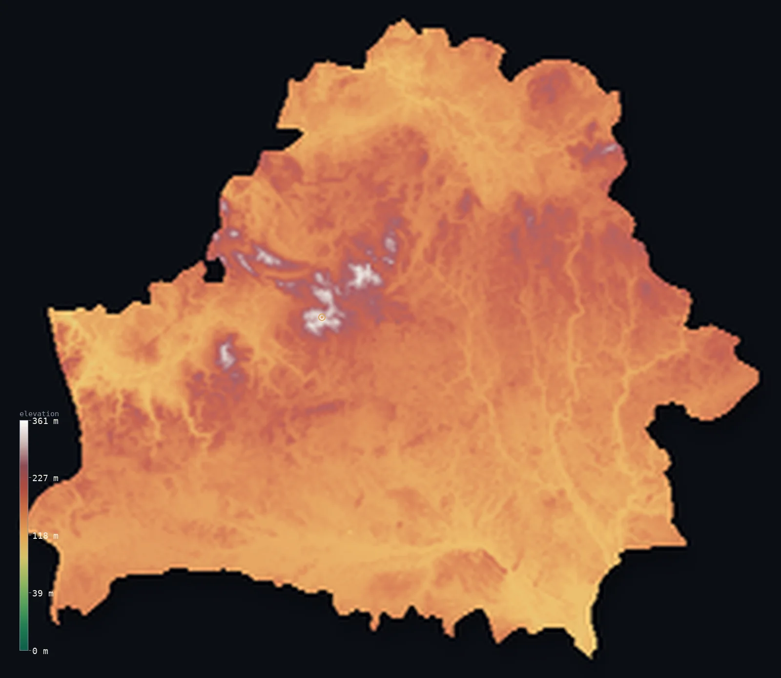
Belarus’s highest point is Dzyarzhynskaya Hara at 1,132 ft (345 m); its lowest is Nyoman River at 295 ft (90 m); the mean elevation is 541 ft (165 m).
Belarus is a country almost without relief — a broad, low plain in Eastern Europe, landlocked between Poland and Russia. There are no mountains anywhere: the highest point, Dzyarzhynskaya Hara, reaches just 1,132 ft (345 m), and it sits near the centre of the country, so the land seems to slope gently away from it in every direction. What defines Belarus instead is water and forest — some 11,000 lakes, thousands of rivers, the vast Pripet Marshes of the south, and woodland over more than 40% of the land. More than half the country lies below 656 ft (200 m).
- Highest point📚
- 1,132 ft345 m
- Belarus's highest point is Dzyarzhynskaya Hara at 1,132 ft (345 m) — and what is striking is not its height but its position. It sits near the middle of the country, on the low Belarusian Ridge, with no higher ground for hundreds of kilometres in any direction; from this gentle rise the land seems to slope away on every side. The nearest real mountains are far off, in the Carpathians beyond Poland and Ukraine.
- Lowest point📚
- 295 ft90 m
- Belarus is landlocked, so its lowest point is not a coast but a river valley — the Nyoman (Neman) at about 295 ft (90 m), where the river flows out of the country toward Lithuania. Even this is only gently low: Belarus has no deep basin or depression, just the broad, slow valleys of its many rivers threading a level land.
- Mean elevation⚙
- 541 ft165 m
- Computed from the GLO-30 model, Belarus's mean elevation is 541 ft (165 m) — low, and more tellingly, remarkably even. There is little to pull the average up or down: Belarus is a country almost without relief, a wide plain of forest, marsh, and slow rivers where the ground seldom strays far from about 160 m.
- Median elevation⚙
- 525 ft160 m
- Half of Belarus lies below about 525 ft (160 m). The country's relief is counted in tens of metres, not hundreds: from the Polesia marshes of the south to the glacial ridges of the north, the land rises and falls only gently, with no part of it truly high and none truly low.
- Elevation range📚
- 837 ft255 m
- The entire vertical range of Belarus is only about 840 ft, from the Nyoman valley at 90 m to the crest of Dzyarzhynskaya Hara at 345 m — and even that modest climb is a matter of low glacial swells spread across a vast plain, not any single slope. The country holds no mountains, cliffs, or gorges anywhere within its borders.
- Official area📚
- 80,155 mi²207,600 km²
- Belarus covers about 80,200 sq mi (207,600 sq km) — a large, landlocked country in Eastern Europe between Poland and Russia, almost entirely low plain: forest, marsh, and the broad valleys of rivers such as the Dnieper, the Nyoman, and the Pripyat.
- Forest cover📚
- 42.7%
- About 42.7% of Belarus is forested — its plains covered by extensive stands of pine, spruce, and birch, including the ancient Belovezhskaya Pushcha (Białowieża Forest) on the Polish border, one of the last remnants of Europe's primeval woodland. Marsh and wetland take up much of the rest.
Highest and lowest points
Belarus's highest point is Dzyarzhynskaya Hara, 1,132 ft (345 m), on the Belarusian Ridge near the centre of the country, southwest of Minsk. It is less a mountain than the crown of a broad glacial upland — but its position is remarkable: no higher land exists for hundreds of kilometres, so from its summit the whole country appears to slope gently away. Originally called Svyataya Hara ('holy mountain'), it was renamed in 1958 after Felix Dzerzhinsky. The ridge it stands on was heaped up by Ice Age glaciers, which shaped nearly all of Belarus's gentle relief.
source ↗Belarus's lowest point is the valley of the Nyoman (Neman) River, at about 295 ft (90 m) above sea level, where the river leaves the country for Lithuania. Landlocked Belarus reaches no sea, so its lowest ground is inland: the floodplains of its great rivers — the Nyoman in the west, the Dnieper through the east, the Pripyat draining the southern marshes. None of it lies far below the general level of the country; Belarus is low and even throughout, without any true depression.
source ↗Belarus at a glance
Belarus is remarkably flat: more than half the country lies below 200 m, and its highest point, Dzyarzhynskaya Hara, is only about 345 m.
source ↗Because Belarus is landlocked, its lowest point is not the sea but the valley of the Nyoman River, at about 90 m above sea level.
source ↗The national high point is unusually central — the nearest higher land is hundreds of kilometres away in Poland, so from its summit the whole country seems to slope away.
source ↗Dzyarzhynskaya Hara was originally called Svyataya Hara ('holy mountain') and was renamed in 1958 after Felix Dzerzhinsky, founder of the Soviet secret police.
source ↗About a third of Belarus is the Polesia lowland and its Pripet Marshes — one of the largest wetland systems in Europe.
source ↗Belarus is exceptionally watery and wooded: around 11,000 lakes, some 10,800 rivers and streams, and more than 40% forest cover.
source ↗The country's gentle terrain was shaped by Ice Age glaciers, which left the northern lakes, moraine ridges and the uplands of the Belarusian Ridge.
source ↗
Elevation profile of Belarus
The largest share of land, 34%, falls in the 150–175 m band, and 100% of the territory lies below 500 m (1,640 ft).
- below 500 m (1,640 ft)100%
Highest peaks of Belarus
| Peak | Elevation | Range | Note |
|---|---|---|---|
| Dzyarzhynskaya Hara↗ | 1,132 ft345 m | Minsk Upland (Belarusian Ridge) | Highest point of Belarus, a flat-topped hill west of Minsk on the Belarusian Ridge. |
| Lysaya Hara↗ | 1,122 ft342 m | Minsk Upland | A neighbouring high point of the Minsk Upland, nearly as high as Dzyarzhynskaya Hara. |
| Navahrudak Upland high point↗ | 1,060 ft323 m | Navahrudak Upland | The high ground of the Navahrudak Upland in the west, another segment of the Belarusian Ridge. |
| Minsk Upland high ground↗ | 1,050 ft320 m | Minsk Upland | The broad glacial upland around Minsk, the most elevated part of the Belarusian Ridge. |
| Vitebsk Upland high ground↗ | 968 ft295 m | Vitebsk Upland | The morainic uplands of the lake-dotted north, formed from glacial debris. |
Belarus: the ridge, the lakes, the plains, and the marshes
The Belarusian Ridge and the northern lakes
A belt of low glacial uplands, the Belarusian Ridge, runs diagonally across the country from southwest to northeast, carrying Dzyarzhynskaya Hara, the national high point. North of it lies a gently hilly lake district — thousands of lakes and low moraine hills left by the retreating Ice Age glaciers that shaped nearly all of Belarus's terrain.
The central plains and rivers
Between the uplands stretch broad, low plains drained by the country's great rivers — the west-flowing Nyoman, the Dnieper running south through the east, and the Berezina and Western Dvina. This is the agricultural heart of Belarus, level and open, rarely far from a river.
Polesia and the Pripet Marshes
About a third of Belarus, in the south around the Pripyat River, is Polesia — a vast, low expanse of marsh, bog, floodplain, and forest, the Pripet Marshes, among the largest wetland systems in Europe. It is the lowest and wettest part of a country already defined by water.
How to read this map
Color shows elevation; the raised relief shows real terrain. On this map Belarus reads as a broad, even plain — low greens almost everywhere, the ground barely rising except for the faint diagonal swell of the Belarusian Ridge through the middle and the low lake country of the north, with the dark wet flats of Polesia in the south.
The 3D relief is the actual GLO-30 elevation data, exaggerated vertically so that a country of such gentle relief shows any shape at all; the ×N relief slider controls how much. Tap anywhere to read that point's exact elevation.
City elevations in Belarus
Belarus's cities are spread evenly across its plains, mostly on the rivers — Minsk near the centre on the Belarusian Ridge, Vitebsk and Mahilyow in the east on the Dvina and Dnieper, Hrodna and Brest in the west, Homyel and Pinsk toward the southern marshes. None sits notably high; the country's gentle relief leaves little to distinguish them by elevation.
| City | Population | Elevation |
|---|---|---|
| Minskcapitalthe capital, near the centre of the country on the Belarusian Ridge — the highest-set of the major cities ↗ | 1,742,124 | 725 ft221 m |
| Homyel'in the southeast on the Sozh River, toward the Polesia lowland ↗ | 501,102 | 459 ft140 m |
| Hrodnain the west on the Nyoman, near the Polish and Lithuanian borders ↗ | 361,115 | 423 ft129 m |
| Vitebskin the northeast on the Western Dvina, in the northern lake district ↗ | 358,395 | 479 ft146 m |
| Mahilyowin the east on the Dnieper ↗ | 353,110 | 597 ft182 m |
| Brestin the far southwest on the Bug River, at the Polish border ↗ | 344,470 | 459 ft140 m |
| Bobruyskin the centre-east on the Berezina River ↗ | 207,351 | 515 ft157 m |
| Baranovichiin the west-central plains ↗ | 171,361 | 646 ft197 m |
| Barysawnortheast of Minsk on the Berezina ↗ | 135,696 | 571 ft174 m |
| Pinskin the south, in the heart of the Polesia marshes ↗ | 124,295 | 469 ft143 m |
Elevation sampled at each city centre from the Copernicus GLO-30 model. Cities and population from GeoNames (CC-BY 4.0).
Belarus in comparison
Belarus's terrain rises 837 ft (255 m) from Nyoman River (295 ft (90 m)) to Dzyarzhynskaya Hara — about 3% of the height of Mount Everest, the world's highest point at 29,032 ft (8,849 m).
- Lithuania's mean elevation is 348 ft — 194 ft lower; its high point, Aukstojas Hill, reaches 965 ft (294 m), 167 ft below. Lithuania elevation map →
- Poland's mean elevation is 571 ft — 30 ft higher; its high point, Rysy, reaches 8,199 ft (2,499 m), 7,067 ft above. Poland elevation map →
- Ukraine's mean elevation is 554 ft — 13 ft higher; its high point, Hoverla, reaches 6,762 ft (2,061 m), 5,630 ft above. Ukraine elevation map →
Frequently asked questions
What is the highest point in Belarus?
- Dzyarzhynskaya Hara, 1,132 ft (345 m), on the Belarusian Ridge near the centre of the country — a low glacial upland with no higher ground for hundreds of kilometres around.
What is the lowest point in Belarus?
- The valley of the Nyoman (Neman) River, about 295 ft (90 m), where it leaves the country for Lithuania — landlocked Belarus reaches no sea.
What is the average elevation of Belarus?
- Computed from the Copernicus GLO-30 model, the area-weighted mean is 541 ft (165 m) — low and very even, as Belarus is a broad plain with no mountains and no deep lowland.
Is Belarus flat?
- Almost entirely — it is a low, even plain of forest, marsh, and rivers, its whole vertical range only about 840 ft. The highest point, Dzyarzhynskaya Hara, is just 345 m and sits near the centre of the country.
What are the Pripet Marshes?
- A vast wetland in the Polesia lowland of southern Belarus, around the Pripyat River — one of the largest marsh systems in Europe, covering about a third of the country's south.
Is this a topographic, relief, contour, or elevation map of Belarus?
- They describe the same thing — terrain height. This page renders the country's actual elevation surface in interactive 3D and reports the statistics computed from it.
About this map
The terrain is rendered from the Copernicus GLO-30 digital elevation model (ESA), masked to the BLR-ADM0 boundary from geoBoundaries (gbOpen). Elevation statistics are computed directly from the model; peak names and researched facts are sourced and cited. See the methodology for the full pipeline.
Our area-weighted mean, computed from the Copernicus GLO-30 model, is 541 ft (165 m); the figure commonly cited elsewhere is 525 ft (160 m) (CIA World Factbook). Belarus is almost uniformly low: more than half the country lies below 200 m and its highest point barely passes 345 m, so its area-weighted mean is low and its median sits close to it. The figure computed here from the Copernicus GLO-30 model, about 165 m, is close to the 160 m commonly cited by the CIA World Factbook.
Surveyed national figures: official area · forest cover · high point.
Rendered from Copernicus GLO-30 (ESA, 2021 release), boundaries from geoBoundaries. Generated 2026-06-22.
Bordering countries · 5
Belarus shares a land border with these countries — open any one to compare its terrain and highest point.