Moldova Elevation Map — Topographic & 3D Terrain
Explore the terrain of Moldova in interactive 3D, built from Copernicus GLO-30 satellite elevation data — a landlocked country of gentle hills and river valleys between the Prut and the Dniester. Drag to rotate, scroll to zoom, and tap any point to read its elevation.
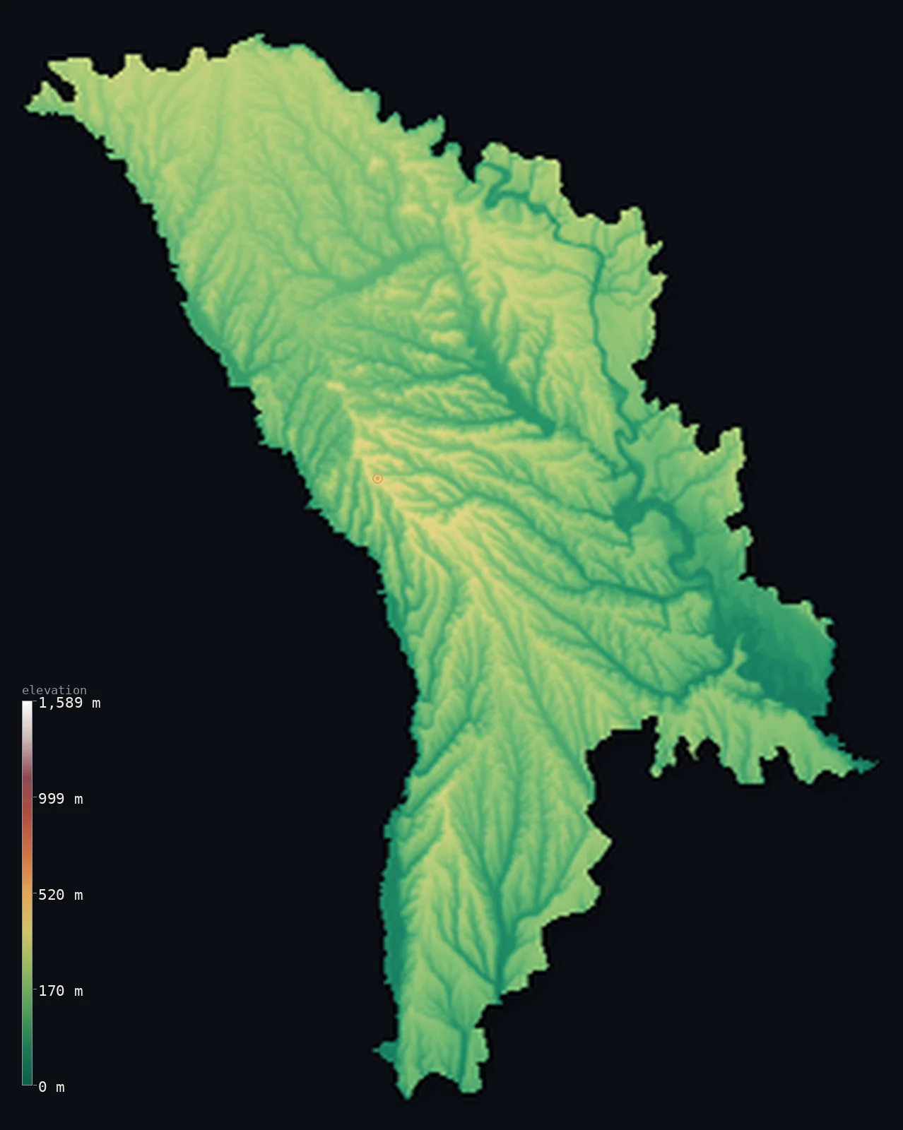
Moldova’s highest point is Balanesti Hill at 1,411 ft (430 m); its lowest is Dniester (Nistru) River at 7 ft (2 m); the mean elevation is 479 ft (146 m).
Moldova is a landlocked country of gentle hills, plateaus, and river valleys, set between two great rivers — the Prut on its western border with Romania and the Dniester running through its east. It is a land of low hills and fertile plains, without mountains: the highest point, Bălănești, is a hill of just 1,411 ft (430 m) in the central Codri uplands. Vineyards, orchards, and farmland cover much of a country known for some of the most fertile soil in Europe. Only about a fifth of it stands above 656 ft (200 m).
- Highest point📚
- 1,411 ft430 m
- Moldova's highest point is Bălănești at 1,411 ft (430 m), a hill in the Codri — the wooded central uplands of the country. It is not a mountain but the high point of a rolling hill country, the most elevated rise in a land of plateaus, valleys, and plains. Even this summit stands amid orchards and forest, in the gentle interior of a low country.
- Lowest point📚
- 7 ft2 m
- Moldova's lowest point is on the Dniester river in the south, at about 7 ft (2 m) — where the river, near the border, runs low toward the Black Sea (which Moldova, landlocked, does not itself reach). It is the low end of a gently tilted country.
- Mean elevation⚙
- 479 ft146 m
- Computed from the GLO-30 model, Moldova's mean elevation is 479 ft (146 m) — low, but not flat: a country of low hills, plateaus, and river valleys between the Prut and the Dniester, gently undulating rather than level, and without mountains.
- Median elevation⚙
- 482 ft147 m
- Half of Moldova lies below 482 ft (147 m) — a low midpoint for a gently rolling country: hills and plateaus cut by river valleys, the highs and lows only a few hundred metres apart, most of it low farmland and hill.
- Elevation range📚
- 1,404 ft428 m
- Moldova rises only about 1,405 ft from end to end, the Dniester to the Codri hill of Bălănești — a small reach for a country of low hills and river valleys, without mountains.
- Official area📚
- 13,068 mi²33,846 km²
- Moldova covers about 13,100 sq mi (33,846 sq km) — a small, landlocked country in eastern Europe, between Romania and Ukraine, a land of low hills and river valleys between the Prut and the Dniester.
- Forest cover📚
- 13.8%
- About 13.8% of Moldova is forested — a modest share, most of it in the central Codri uplands; much of the country is farmland, its famously fertile black-earth soil given over to vineyards, orchards, and crops.
Highest and lowest points
Moldova's highest point is Bălănești, 1,411 ft (430 m), a hill in the Codri — the wooded central uplands that form the highest and most varied terrain in the country. It is a hill, not a mountain: a rise in a gently rolling landscape of plateaus and valleys, wooded on top and surrounded by the orchards and vineyards of Moldova's fertile interior. The Codri are the green heart of a low, agricultural country, and Bălănești their modest summit.
source ↗Moldova's lowest point is on the Dniester river in the south, at about 7 ft (2 m) above sea level, where the river runs low near the country's southeastern edge before continuing through Ukraine to the Black Sea. Landlocked Moldova has no coast of its own — it comes within a few miles of the sea in the south but does not reach it — and drains through the Dniester and the Prut, which frame the country east and west. Even its lowest ground sits only just above the sea.
source ↗Moldova at a glance
No point in Moldova reaches even 450 m — its high point, Bălănești Hill, is just 430 m, in a low, gently undulating country of hills, plateaus, and river valleys.
source ↗About three-quarters of Moldova is covered by chernozem - the fertile 'black earth' that makes it one of the most arable countries in Europe.
source ↗Moldova is landlocked but comes within about 3 km of the Black Sea, separated from the Dniester Liman estuary only by a strip of Ukrainian territory.
source ↗The name Codri, used for the central forested hills, simply means 'forests' - the woods that once covered far more of the country before 19th-century clearing.
source ↗Over 95% of Moldova's water drains into just two rivers, the Prut and the Dniester, both running south to the Black Sea.
source ↗Bălănești Hill, at 430 m, is a low national high point — higher than any of the Baltic states' summits (Estonia 318, Latvia 312, Lithuania 294 m) but far below any mountain.
source ↗
Elevation profile of Moldova
The largest share of land, 27%, falls in the 150–200 m band, and 100% of the territory lies below 500 m (1,640 ft).
- below 500 m (1,640 ft)100%
Highest peaks of Moldova
| Peak | Elevation | Range | Note |
|---|---|---|---|
| Balanesti Hill↗ | 1,411 ft430 m | Cornesti Hills / Codri Plateau (centre) | Highest point of Moldova, a forested hill of the Central Moldavian Plateau. |
| Dniester Ridge (high point)↗ | 1,138 ft347 m | Dniester Hills (north) | The high right bank of the Dniester in the north, the country's second-highest upland. |
| Northern Moldavian Plateau (high ground)↗ | 1,050 ft320 m | Northern Moldavian Plateau (north) | The gently rolling northern uplands, reaching about 320 m. |
Moldova: the Codri uplands, the two rivers, and the plains
The central uplands (the Codri)
The centre of Moldova rises into the Codri — wooded uplands of low hills and plateaus, holding Bălănești, the country's high point. The highest, greenest, and most forested part of the country, they are hills rather than mountains, cut by valleys and dotted with orchards and vineyards.
The river valleys (Prut and Dniester)
Moldova is framed and drained by two great rivers — the Prut along the western border with Romania and the Dniester through the east — with their valleys and floodplains forming the country's lower ground. The rivers define the country's shape and much of its border.
The plains and farmland
Between and beyond the hills lie Moldova's plains, especially in the south — gently rolling farmland on deep, fertile black soil, given over to crops, orchards, and vineyards. This agricultural lowland, low and open, covers much of the country.
How to read this map
Color shows elevation; the raised relief shows real terrain. On this map Moldova reads as gently rolling country — low greens of river valley and plain, especially in the south, rising to the slightly higher, wooded central Codri uplands where Bălănești sits, framed by the valleys of the Prut in the west and the Dniester in the east.
The 3D relief is the actual GLO-30 elevation data, exaggerated vertically so that a country of such gentle relief shows its shape; the ×N relief slider controls how much. Tap anywhere to read that point's exact elevation.
Moldova in comparison
Moldova's terrain rises 1,404 ft (428 m) from Dniester (Nistru) River (7 ft (2 m)) to Balanesti Hill — about 5% of the height of Mount Everest, the world's highest point at 29,032 ft (8,849 m).
- Romania's mean elevation is 1,312 ft — 833 ft higher; its high point, Moldoveanu, reaches 8,346 ft (2,544 m), 6,936 ft above. Romania elevation map →
- Ukraine's mean elevation is 554 ft — 75 ft higher; its high point, Hoverla, reaches 6,762 ft (2,061 m), 5,351 ft above. Ukraine elevation map →
- Lithuania's mean elevation is 348 ft — 131 ft lower; its high point, Aukstojas Hill, reaches 965 ft (294 m), 446 ft below. Lithuania elevation map →
Frequently asked questions
What is the highest point in Moldova?
- Bălănești, 1,411 ft (430 m), a hill in the central Codri uplands — not a mountain but the high point of a rolling hill country.
What is the lowest point in Moldova?
- On the Dniester river in the south, at about 7 ft (2 m) — where the river runs low near the border, in a landlocked country that does not quite reach the Black Sea.
What is the average elevation of Moldova?
- Computed from the Copernicus GLO-30 model, the area-weighted mean is 479 ft (146 m) — low, because Moldova is a country of low hills, plateaus, and river valleys, with no mountains.
Is Moldova mountainous?
- No — it has no mountains, only low hills and plateaus, with a highest point of just 430 m in the central Codri uplands. Much of the country is fertile, gently rolling farmland.
Why is Moldova known for wine?
- Its low hills and deep, fertile black-earth soil suit vineyards, and wine-growing is central to Moldova's economy and identity.
Is this a topographic, relief, contour, or elevation map of Moldova?
- They describe the same thing — terrain height. This page renders the country's actual elevation surface in interactive 3D and reports the statistics computed from it.
About this map
The terrain is rendered from the Copernicus GLO-30 digital elevation model (ESA), masked to the MDA-ADM0 boundary from geoBoundaries (gbOpen). Elevation statistics are computed directly from the model; peak names and researched facts are sourced and cited. See the methodology for the full pipeline.
Our area-weighted mean, computed from the Copernicus GLO-30 model, is 479 ft (146 m); the figure commonly cited elsewhere is 456 ft (139 m) (CIA World Factbook). Moldova is gently rolling forest-steppe and plains on the Moldavian Plateau, with no point above 430 m, so its mean elevation is low; the page reports the area-weighted figure computed from the Copernicus GLO-30 model.
Surveyed national figures: official area · forest cover · high point.
Rendered from Copernicus GLO-30 (ESA, 2021 release), boundaries from geoBoundaries. Generated 2026-06-24.
Bordering countries · 2
Moldova shares a land border with these countries — open any one to compare its terrain and highest point.