Bolivia Elevation Map — Topographic & 3D Terrain
Explore the terrain of Bolivia in interactive 3D, built from Copernicus GLO-30 satellite elevation data — the high Altiplano and Andes above vast eastern lowlands. Drag to rotate, scroll to zoom, and tap any point to read its elevation.
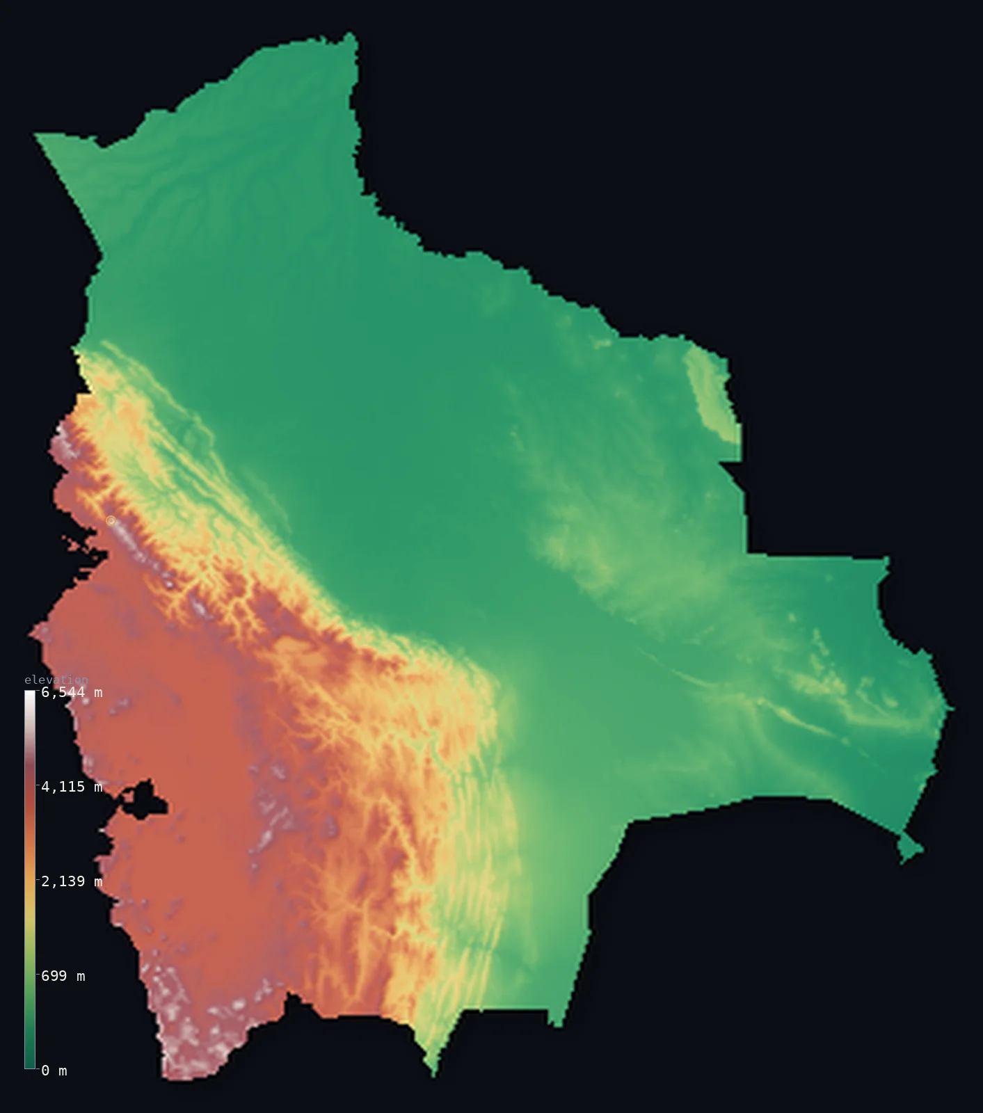
Bolivia’s highest point is Nevado Sajama at 21,463 ft (6,542 m); its lowest is Paraguay River at 295 ft (90 m); the mean elevation is 4,042 ft (1,232 m).
Bolivia is a landlocked country of two halves — a high Andean west and a low tropical east. In the west, the Andes split into two great ranges enclosing the Altiplano, a vast, cold, high plateau lying around 12,000 ft, one of the highest and largest plateaus on Earth, holding Lake Titicaca and the salt flats and, on the western range, Bolivia's highest peaks — Nevado Sajama reaches 21,463 ft (6,542 m). But this high country, though it holds much of the population and the seat of government at La Paz, is less than half of Bolivia: to the east, the land drops steeply to vast lowlands — the Amazon rainforest of the north and the dry Chaco plains of the south — which cover most of the country. So while Bolivia is famous for its heights, more than half of it lies below about 1,000 ft, in the eastern lowlands.
- Highest point📚
- 21,463 ft6,542 m
- Bolivia's highest point is Nevado Sajama at 21,463 ft (6,542 m), an extinct volcano in the west, near the Chilean border — a snow-capped cone standing alone above the Altiplano, the highest mountain in Bolivia. It rises from the high western range of the Andes, high above the great plateau that itself lies around 3,700 m — so that even the plain at its foot is higher than most of the world's mountains.
- Lowest point📚
- 295 ft90 m
- Bolivia's lowest point is on the Paraguay River in the far southeast at about 295 ft (90 m) — in the low tropical lowlands where the country meets Paraguay and Brazil, a world away from the high Andes of the west. Landlocked Bolivia falls from some of the highest inhabited country on Earth to hot lowland plains.
- Mean elevation⚙
- 4,042 ft1,232 m
- Computed from the GLO-30 model, Bolivia's mean elevation is 4,042 ft (1,232 m) — moderate, and misleading. Bolivia is famous for its heights, but the great Altiplano and Andes fill only the western third; the vast Amazon and Chaco lowlands of the east cover most of the country and hold the median down to 1,030 ft (314 m). So the mean is a highland figure imposed on a mostly-lowland country.
- Median elevation⚙
- 1,030 ft314 m
- Half of Bolivia lies below about 1,030 ft (314 m) — a low figure that may surprise, for Bolivia is famous for its heights. But the great Altiplano and the Andes, however high, cover less than half the country: the vast eastern lowlands of the Amazon and the Chaco make up most of Bolivia's area, and pull the typical point down low, far below the high plateau of the west.
- Elevation range📚
- 21,168 ft6,452 m
- From the Paraguay River to the summit of Nevado Sajama at 6,542 m, Bolivia's terrain climbs about 21,170 ft — one of the greatest ranges of any country, from hot tropical lowland plains to a snow-capped Andean volcano, across a country split between a high plateau west and a low tropical east.
- Above 1,000 m (3,281 ft)⚙
- 33%
- About 33% of Bolivia rises above 1,000 m (3,281 ft) — the Andes and the high Altiplano of the west, including the great plateau and its enclosing ranges. The vast eastern lowlands — the Amazon in the north and the Chaco in the south — lie below.
- Above 2,000 m (6,562 ft)⚙
- 26%
- Roughly 26% of Bolivia stands above 2,000 m (6,562 ft) — the high western third of the country: the Altiplano, lying around 3,700 m, and the Andean ranges that enclose and rise above it, the great high heart of Bolivia.
- Official area📚
- 424,164 mi²1,098,581 km²
- Bolivia covers about 424,000 sq mi (1,098,581 sq km) — a landlocked South American country of two halves: the high Andes and the vast Altiplano plateau in the west (holding Lake Titicaca, the salt flats, and Nevado Sajama), and the low eastern lowlands of the Amazon and the Chaco, which cover most of the country.
- Forest cover📚
- 50.6%
- About 51% of Bolivia is forested — vast Amazon rainforest across the northern and eastern lowlands, dry Chaco woodland in the southeast, and treeless high puna grassland on the cold Altiplano of the west.
Highest and lowest points
Bolivia's highest point is Nevado Sajama, 21,463 ft (6,542 m), an extinct volcano in the far west near the Chilean border — a solitary snow-capped cone, the highest mountain in Bolivia, standing above the Altiplano in the Cordillera Occidental. What is striking is that even the plateau at its base lies around 3,700 m — higher than almost any mountain in Europe or North America — so that Sajama rises from an already-lofty floor. It is the greatest of the peaks of the Bolivian Andes, which split into two ranges in the west: the Cordillera Occidental along the Chilean border (volcanic, holding Sajama) and the Cordillera Real behind La Paz (holding Illimani and Ancohuma, nearly as high). Between them spreads the Altiplano. All of this high country — plateau and ranges — is the western third of Bolivia; east of it the land drops to the vast Amazon and Chaco lowlands that make up most of the country.
source ↗Bolivia's lowest point is on the Paraguay River in the far southeast, at about 295 ft (90 m) above sea level — in the hot, low lowlands where Bolivia meets Paraguay and Brazil, part of the great Pantanal wetland region. This is a world away from the Andes: landlocked Bolivia is a country of two halves. The western third is high — the Andes split into two ranges, the Cordillera Occidental (holding Nevado Sajama, the high point) and the Cordillera Real, enclosing between them the Altiplano, a vast, cold, high plateau around 3,700 m that holds Lake Titicaca (the highest large navigable lake in the world, shared with Peru), the great salt flat of Uyuni, and the government seat of La Paz. But east of the Andes the land falls away into the lowlands that make up most of Bolivia — the Amazon rainforest of the north (the Beni) and the dry Chaco plains of the south — vast, low, and tropical. Bolivia lost its Pacific coast to Chile in the 19th century and has been landlocked since.
source ↗Bolivia at a glance
Bolivia is a country of two halves - a high Andean west (the Altiplano plateau around 3,700 m and the Andes) and a low tropical east (the Amazon and the Chaco), which covers most of the country.
source ↗Despite its fame for heights, more than half of Bolivia lies below about 1,000 ft - the vast eastern lowlands of the Amazon and the Chaco make up most of the country's area.
source ↗The Altiplano of western Bolivia is one of the highest and largest plateaus on Earth - a vast, cold, high plain around 3,700 m, holding Lake Titicaca and the great salt flat of Uyuni.
source ↗Lake Titicaca, on the Bolivia-Peru border, is the highest large navigable lake in the world - high on the Altiplano at about 3,810 m.
source ↗The Salar de Uyuni in southwestern Bolivia is the world's largest salt flat - a vast, blinding-white plain of salt on the high Altiplano.
source ↗La Paz, Bolivia's seat of government, is the highest capital city in the world - high in a canyon on the edge of the Altiplano.
source ↗
Elevation profile of Bolivia
The largest share of land, 62%, falls in the 0–500 m band, and 62% of the territory lies below 500 m (1,640 ft).
- below 500 m (1,640 ft)62%
- 500–1,000 m6%
- 1,000–2,000 m7%
- above 2,000 m (6,562 ft)26%
Highest peaks of Bolivia
| Peak | Elevation | Range | Note |
|---|---|---|---|
| Nevado Sajama↗ | 21,463 ft6,542 m | Cordillera Occidental | Highest point of Bolivia, an extinct ice-capped stratovolcano near the Chilean border. |
| Illimani↗ | 21,122 ft6,438 m | Cordillera Real (Cordillera Oriental) | The highest peak of the Cordillera Real and second-highest in Bolivia, towering over La Paz with large glaciers. |
| Illampu↗ | 21,076 ft6,424 m | Cordillera Real | A heavily glaciated granite peak at the northern end of the Cordillera Real, above Lake Titicaca. |
| Parinacota↗ | 20,827 ft6,348 m | Cordillera Occidental (Nevados de Payachata) | A symmetrical volcano on the Chile–Bolivia border, one of the twin Nevados de Payachata. |
| Pomerape↗ | 20,610 ft6,282 m | Cordillera Occidental (Nevados de Payachata) | The other of the twin Payachata volcanoes, resembling Sajama, on the Chilean border. |
Bolivia: the Andes and the Altiplano, the Amazon lowlands, and the Chaco
The Andes and the Altiplano (the west)
Western Bolivia is high — the Andes split into two great ranges, the Cordillera Occidental (volcanic, holding Nevado Sajama, the high point) and the Cordillera Real, enclosing the Altiplano, a vast cold plateau around 3,700 m with Lake Titicaca, the Uyuni salt flat, and La Paz. The high, populous, but minority third of the country.
The Amazon lowlands (the north and east)
North and east of the Andes the land falls to the vast Amazon lowlands — the Beni and Santa Cruz plains, tropical rainforest and savanna drained by Amazon tributaries. Low, hot, and green, they cover much of the country and hold the booming city of Santa Cruz.
The Chaco (the southeast)
The far southeast is the Gran Chaco — a low, hot, dry plain of scrub and thorn forest, sloping toward Paraguay and the country's lowest point. The dry lowland corner of Bolivia.
How to read this map
Color shows elevation; the raised relief shows real terrain. On this map Bolivia reads as two halves — the high browns and whites of the Andes and the vast Altiplano filling the western third (the double ranges enclosing the high plateau, highest at Nevado Sajama, with Lake Titicaca and the salt flats), dropping steeply eastward to the broad low green of the Amazon lowlands in the north and east and the Chaco in the southeast.
The 3D relief is the actual GLO-30 elevation data, exaggerated vertically so the high plateau and the low lowlands both show — though on the Altiplano even the 'low' ground is very high; the ×N relief slider controls how much. Tap anywhere to read that point's exact elevation.
City elevations in Bolivia
Bolivia's cities split between the highlands and the lowlands — La Paz, the seat of government, high on the Altiplano's edge (the highest capital in the world), Cochabamba in a highland valley, Sucre (the constitutional capital) in the south, and the booming Santa Cruz in the eastern lowlands. The high west and the low east each hold great cities.
| City | Population | Elevation |
|---|---|---|
| La Pazthe seat of government, high on the Altiplano's edge - the highest capital in the world ↗ | 2,004,652 | 12,365 ft3,769 m |
| Santa Cruz de la Sierrain the eastern Amazon lowlands ↗ | 1,831,434 | 1,375 ft419 m |
| Cochabambain a central highland valley ↗ | 841,276 | 8,419 ft2,566 m |
| Sucrecapitalthe constitutional capital, in a southern highland valley ↗ | 224,838 | 9,170 ft2,795 m |
| Tarijain a southern valley, toward Argentina ↗ | 159,269 | 6,129 ft1,868 m |
| Riberaltain the far northern Amazon lowlands ↗ | 99,070 | 479 ft146 m |
| Trinidadin the northeastern Beni (Amazon) lowlands ↗ | 84,259 | 515 ft157 m |
| Yacuibain the far south on the Argentine border, in the Chaco ↗ | 82,803 | 2,047 ft624 m |
| Llallaguaa highland mining town on the Altiplano ↗ | 28,069 | 12,575 ft3,833 m |
| Camiriin the southeastern Chaco foothills ↗ | 27,961 | 2,703 ft824 m |
Elevation sampled at each city centre from the Copernicus GLO-30 model. Cities and population from GeoNames (CC-BY 4.0).
Bolivia in comparison
Bolivia's terrain rises 21,168 ft (6,452 m) from Paraguay River (295 ft (90 m)) to Nevado Sajama — about 73% of the height of Mount Everest, the world's highest point at 29,032 ft (8,849 m).
- Peru's mean elevation is 4,810 ft — 768 ft higher; its high point, Huascaran, reaches 22,205 ft (6,768 m), 741 ft above. Peru elevation map →
- Chile's mean elevation is 4,341 ft — 299 ft higher; its high point, Ojos del Salado, reaches 22,615 ft (6,893 m), 1,152 ft above. Chile elevation map →
- Argentina's mean elevation is 2,323 ft — 1,719 ft lower; its high point, Cerro Aconcagua, reaches 22,838 ft (6,961 m), 1,375 ft above. Argentina elevation map →
- Paraguay's mean elevation is 535 ft — 3,507 ft lower; its high point, Cerro Tres Kandu, reaches 2,762 ft (842 m), 18,701 ft below. Paraguay elevation map →
Frequently asked questions
What is the highest point in Bolivia?
- Nevado Sajama, 21,463 ft (6,542 m), an extinct volcano in the far west near Chile - a snow-capped cone rising above the Altiplano, itself already around 3,700 m.
What is the lowest point in Bolivia?
- On the Paraguay River in the far southeast, at about 295 ft (90 m) - in the low tropical lowlands where Bolivia meets Paraguay and Brazil.
What is the average elevation of Bolivia?
- Computed from the Copernicus GLO-30 model, the area-weighted mean is 4,042 ft (1,232 m) - but for Bolivia that figure is misleading: the high Altiplano and Andes are only the western third, so more than half of Bolivia lies below 1,030 ft (314 m), in the vast eastern Amazon and Chaco lowlands.
Is Bolivia mostly high?
- No - though it is famous for the high Altiplano and Andes of the west, which hold most of the population, more than half of Bolivia lies below about 1,000 ft. The vast eastern lowlands - the Amazon and the Chaco - cover most of the country; the high country is the western third.
What is the Altiplano?
- A vast, cold, high plateau in western Bolivia (and Peru), lying around 3,700 m between two ranges of the Andes - one of the highest and largest plateaus on Earth, holding Lake Titicaca and the Uyuni salt flat.
Is this a topographic, relief, contour, or elevation map of Bolivia?
- They describe the same thing - terrain height. This page renders the country's actual elevation surface in interactive 3D and reports the statistics computed from it.
About this map
The terrain is rendered from the Copernicus GLO-30 digital elevation model (ESA), masked to the BOL-ADM0 boundary from geoBoundaries (gbOpen). Elevation statistics are computed directly from the model; peak names and researched facts are sourced and cited. See the methodology for the full pipeline.
Our area-weighted mean, computed from the Copernicus GLO-30 model, is 4,042 ft (1,232 m); the figure commonly cited elsewhere is 3,911 ft (1,192 m) (CIA World Factbook). Bolivia is famous for its heights, but the fame is misleading. The high Andes and the vast Altiplano — the plateau lies around 3,700 m — fill the western third of the country and hold much of the population, but they are less than half of it. East of the mountains spread the great lowlands: the Amazon in the north, the Chaco in the south, hot and low and covering most of Bolivia. So more than half the country lies below about 1,030 ft (314 m). The computed mean is raised high above the typical point by the western highlands, not by the bulk of the land.
Surveyed national figures: official area · forest cover · high point.
Rendered from Copernicus GLO-30 (ESA, 2021 release), boundaries from geoBoundaries. Generated 2026-06-22.
Bordering countries · 5
Bolivia shares a land border with these countries — open any one to compare its terrain and highest point.