Argentina Elevation Map — Topographic & 3D Terrain
Explore the terrain of Argentina in interactive 3D, built from Copernicus GLO-30 satellite elevation data — the Andes on one edge, the flat Pampas across the middle. Drag to rotate, scroll to zoom, and tap any point to read its elevation.
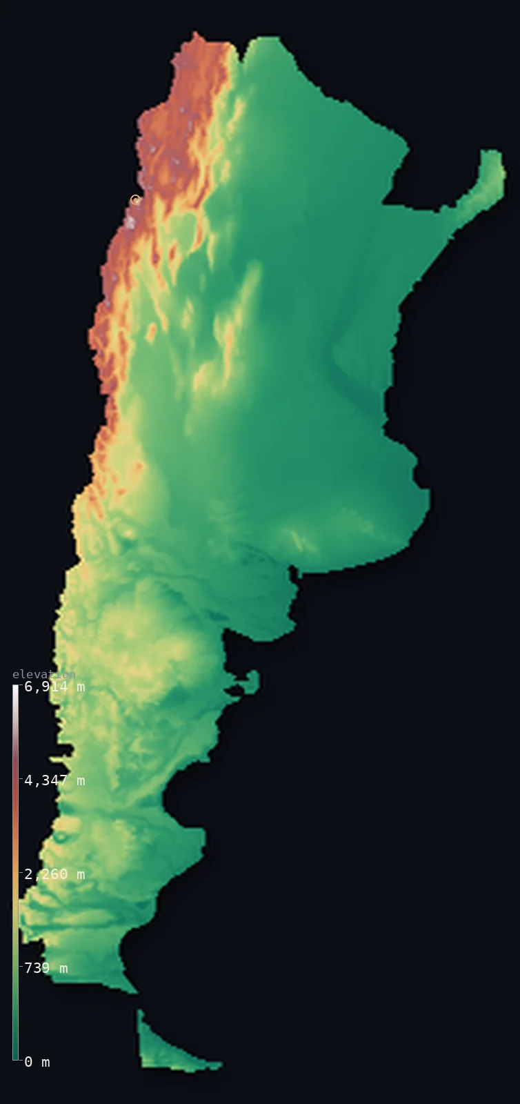
Argentina’s highest point is Cerro Aconcagua at 22,838 ft (6,961 m); its lowest is Laguna del Carbon at −344 ft (−105 m); the mean elevation is 2,323 ft (708 m).
Argentina holds both of the Southern Hemisphere's extremes. Along its western border stands Cerro Aconcagua at 22,838 ft (6,961 m) — the highest mountain outside Asia — and a few hundred kilometres south, in Patagonia, lies the Laguna del Carbón at 344 ft (105 m) below sea level, the lowest point in the hemisphere. Between them the country is mostly flat: half of it lies below 899 ft (274 m), across the Pampas and the Patagonian steppe.
- Highest point📚
- 22,838 ft6,961 m
- Argentina's highest point is Cerro Aconcagua at 22,838 ft (6,961 m) — the highest mountain outside Asia, and the highest in both the Southern and Western Hemispheres, standing in the Andes near the Chilean border.
- Lowest point📚
- −344 ft−105 m
- Argentina's lowest point is the Laguna del Carbón in Santa Cruz province, 344 ft (105 m) below sea level — a salt flat on the Patagonian steppe and the lowest point anywhere in the Southern Hemisphere.
- Mean elevation⚙
- 2,323 ft708 m
- Argentina's mean elevation computed from the GLO-30 model is 2,323 ft (708 m) — a figure pulled upward by the Andean west, since the country's populous centre and east are almost entirely low plain.
- Median elevation⚙
- 899 ft274 m
- Half of Argentina lies below 899 ft (274 m) — barely a third of the mean, and the sharpest possible statement of the country's shape: a narrow wall of very high mountains along one edge, and an enormous expanse of flat, low ground everywhere else.
- Elevation range📚
- 23,182 ft7,066 m
- From the Laguna del Carbón to the summit of Aconcagua, Argentina spans nearly 23,200 ft — the full range of the Southern Hemisphere, from its lowest land to its highest peak, both within one country.
- Above 1,000 m (3,281 ft)⚙
- 20%
- About 20% of Argentina rises above 1,000 m (3,281 ft) — almost entirely the Andean cordillera along the Chilean border and the dry high plateau of the northwest, the Puna.
- Above 2,000 m (6,562 ft)⚙
- 10%
- Roughly 10% of Argentina stands above 2,000 m (6,562 ft) — the high Andes and the Puna plateau, where volcanic peaks over 6,000 m rise from ground already thousands of metres up.
- Official area📚
- 1,073,518 mi²2,780,400 km²
- Argentina covers about 1.07 million sq mi (2.78 million sq km) — a country so long north to south that it reaches from the subtropics to within sight of Antarctica, taking in desert, wetland, prairie, and glacier.
- Forest cover📚
- 9.8%
- Only about 10% of Argentina is forested — the country is overwhelmingly grassland, steppe, and high desert, with woodland confined to the humid northeast and the cool Andean south.
Highest and lowest points
Argentina's highest point is Cerro Aconcagua, 22,838 ft (6,961 m), in the Andes of Mendoza province near the Chilean border — the highest mountain outside Asia, and the highest in both the Southern and Western Hemispheres. Unlike most peaks of its size it can be climbed by a non-technical route, which has made it the most-attempted of the world's great summits. It stands just inside Argentine territory, a few kilometres from the frontier.
source ↗Argentina's lowest point is the Laguna del Carbón, a salt flat in the Gran Bajo de San Julián of Santa Cruz province, 344 ft (105 m) below sea level — the lowest point on land anywhere in the Southern Hemisphere. It lies in the empty, wind-scoured Patagonian steppe, a shallow depression far from any sea, and it is a striking companion to Aconcagua: one country holds both the hemisphere's floor and its ceiling.
source ↗Argentina at a glance
Cerro Aconcagua, 6,961 m, is the highest mountain outside Asia and the highest in both the Southern and Western Hemispheres.
source ↗The Laguna del Carbón in Patagonia, 105 m below sea level, is the lowest point in the Southern Hemisphere - and it lies in the same country as the hemisphere's highest peak.
source ↗Half of Argentina lies below about 274 m - the Pampas and the Patagonian steppe make it far flatter than its Andean reputation suggests.
source ↗The Pampas, the fertile grassland plain around Buenos Aires, is so level it stretches for hundreds of kilometres with barely any change in height.
source ↗The Puna de Atacama in Argentina's northwest is a high desert plateau above 3,000 m, studded with volcanoes over 6,000 m.
source ↗Argentina stretches more than 3,600 km north to south, from the subtropics to the cold seas near Antarctica.
source ↗
Elevation profile of Argentina
The largest share of land, 64%, falls in the 0–500 m band, and 65% of the territory lies below 500 m (1,640 ft).
- below 500 m (1,640 ft)65%
- 500–1,000 m16%
- 1,000–2,000 m10%
- above 2,000 m (6,562 ft)10%
Highest peaks of Argentina
| Peak | Elevation | Range | Note |
|---|---|---|---|
| Cerro Aconcagua↗ | 22,838 ft6,961 m | Andes (Mendoza) | Highest point of Argentina and of the Americas, in the Mendoza Andes. |
| Ojos del Salado↗ | 22,615 ft6,893 m | Andes (Catamarca, Chilean border) | The highest active volcano on Earth, on the Chilean border; its summit is shared with Chile. |
| Monte Pissis↗ | 22,287 ft6,793 m | Andes (Catamarca-La Rioja) | A giant volcano of the northwest Andes, among the highest peaks in the Americas. |
| Cerro Bonete↗ | 22,175 ft6,759 m | Andes (La Rioja) | A high Andean peak of La Rioja Province in the northwest. |
| Mercedario↗ | 22,047 ft6,720 m | Andes (San Juan) | A high summit of the San Juan Andes, north of Aconcagua. |
Argentina from the Andes to the sea
The Andes and the northwest
Argentina's western edge is the Andean cordillera, carrying Aconcagua and a crowd of peaks above 6,000 m along the Chilean border. In the northwest the range broadens into the Puna, a cold high desert plateau above 3,000 m dotted with volcanoes and salt flats.
The Pampas and the northern plains
The centre and east are plain — the Pampas around Buenos Aires, some of the most fertile grassland on Earth and so flat it barely rises for hundreds of kilometres, and to the north the wetlands and low country of the Chaco and Mesopotamia between the great rivers.
Patagonia
South of the Pampas the land becomes Patagonia — a dry, windswept steppe of terraced plateaus stepping down from the Andes to the Atlantic, holding both the hemisphere's lowest point at the Laguna del Carbón and, along the mountains, the great southern icefields.
How to read this map
Color shows elevation; the raised relief shows real terrain. On this map Argentina reads as a narrow white-and-brown Andean wall down the western edge, with a vast flat green expanse — the Pampas and the steppe — filling everything east of it.
The 3D relief is the actual GLO-30 elevation data, exaggerated vertically so both the mountain wall and the subtle steps of Patagonia show; the ×N relief slider controls how much. Tap anywhere to read that point's exact elevation.
City elevations in Argentina
Argentina's cities are mostly lowland cities — Buenos Aires and Rosario on the flat Pampas near the river, barely above sea level. Only in the northwest, toward the Andes, do places like Salta and Córdoba stand meaningfully higher.
| City | Population | Elevation |
|---|---|---|
| Córdobain the low hills at the edge of the Pampas, at about 390 m ↗ | 2,106,734 | 1,286 ft392 m |
| Rosarioon the flat Paraná riverbank of the Pampas, barely above sea level ↗ | 948,312 | 115 ft35 m |
| Mar del Plata | 593,337 | 52 ft16 m |
| San Miguel de Tucumán | 548,866 | 1,480 ft451 m |
| Saltain a northwestern Andean valley at about 1,180 m, the highest of the big cities ↗ | 520,683 | 3,865 ft1,178 m |
| Santa Fe | 391,164 | 75 ft23 m |
| Corrientes | 346,334 | 203 ft62 m |
| Posadas | 305,874 | 397 ft121 m |
| Bahía Blanca | 299,101 | 85 ft26 m |
| Merlo | 268,961 | 59 ft18 m |
Elevation sampled at each city centre from the Copernicus GLO-30 model. Cities and population from GeoNames (CC-BY 4.0).
Argentina in comparison
Argentina's terrain rises 23,182 ft (7,066 m) from Laguna del Carbon, 344 ft (105 m) below sea level to Cerro Aconcagua — about 80% of the height of Mount Everest, the world's highest point at 29,032 ft (8,849 m).
- Chile's mean elevation is 4,341 ft — 2,018 ft higher; its high point, Ojos del Salado, reaches 22,615 ft (6,893 m), 223 ft below. Chile elevation map →
- Bolivia's mean elevation is 4,042 ft — 1,719 ft higher; its high point, Nevado Sajama, reaches 21,463 ft (6,542 m), 1,375 ft below. Bolivia elevation map →
- Brazil's mean elevation is 1,050 ft — 1,273 ft lower; its high point, Pico da Neblina, reaches 9,826 ft (2,995 m), 13,012 ft below. Brazil elevation map →
Frequently asked questions
What is the highest point in Argentina?
- Cerro Aconcagua, 22,838 ft (6,961 m), in the Andes near the Chilean border - the highest mountain outside Asia and the highest in the Southern and Western Hemispheres.
What is the lowest point in Argentina?
- The Laguna del Carbón in Patagonia, 344 ft (105 m) below sea level - the lowest point in the entire Southern Hemisphere.
What is the average elevation of Argentina?
- Computed from the Copernicus GLO-30 model, the area-weighted mean is 2,323 ft (708 m) - lifted by the Andes, though half the country lies below about 274 m.
Is Argentina flat or mountainous?
- Both, sharply divided: a narrow wall of very high Andes along the western border, and an enormous expanse of flat Pampas and Patagonian steppe across the rest.
What are the Pampas?
- The vast fertile grassland plain around Buenos Aires - so level it stretches for hundreds of kilometres with almost no change in elevation, and the agricultural heart of the country.
Is this a topographic, relief, contour, or elevation map of Argentina?
- They describe the same thing - terrain height. This page renders the country's actual elevation surface in interactive 3D and reports the statistics computed from it.
About this map
The terrain is rendered from the Copernicus GLO-30 digital elevation model (ESA), masked to the ARG-ADM0 boundary from geoBoundaries (gbOpen). Elevation statistics are computed directly from the model; peak names and researched facts are sourced and cited. See the methodology for the full pipeline.
This map renders 2,775,979 km² across 2 landmasses of Argentina. One smaller outlying part — 569 km² in total — lies beyond the area shown here. Area statistics above count the full territory.
Because Argentina covers 2,775,979 km², its 3D terrain surface is rendered at roughly 1.5 km per pixel rather than the model’s native 30 m — the full-resolution grid exceeds the render budget for an area this large. The high point and every elevation figure on this page are still measured at native 30 m resolution; only the rendered surface detail is coarsened.
Our area-weighted mean, computed from the Copernicus GLO-30 model, is 2,323 ft (708 m); the figure commonly cited elsewhere is 1,952 ft (595 m) (CIA World Factbook). Argentina spans the high Andes along its western edge and vast lowland plains across its centre and east, giving a moderate mean; the page reports the area-weighted figure computed from the Copernicus GLO-30 model, shown at reduced surface resolution for a country this large.
Surveyed national figures: official area · forest cover · high point.
Rendered from Copernicus GLO-30 (ESA, 2021 release), boundaries from geoBoundaries. Generated 2026-07-12.
Bordering countries · 5
Argentina shares a land border with these countries — open any one to compare its terrain and highest point.