South America Elevation Map
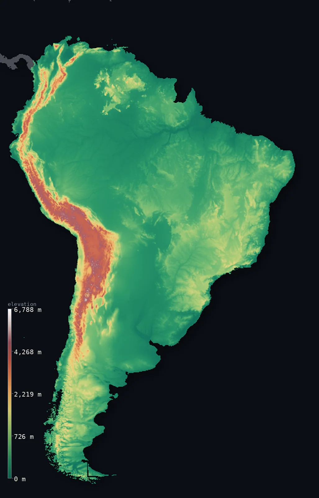
South America’s highest point is Aconcagua at 22,838 ft (6,961 m); its lowest is Laguna del Carbón at −344 ft (−105 m); the mean elevation is 1,906 ft (581 m).
- Highest point📚
- 22,838 ft6,961 m
- South America's highest point is Aconcagua at 22,838 ft (6,961 m), in the Andes of western Argentina, near the Chilean border - the highest mountain in the Americas and the highest anywhere outside Asia. It is a great peak of the high Andes, the mountain chain that runs unbroken down the entire western edge of the continent, and Aconcagua is its summit - the roof of the Western Hemisphere.
- Lowest point📚
- −344 ft−105 m
- South America's lowest point is Laguna del Carbón, in the Gran Bajo de San Julián of southern Argentine Patagonia, at about 344 ft (105 m) below sea level - a dry salt basin, the lowest point in the Americas and in the Southern Hemisphere. It lies far from the great mountains, in the arid steppe of Patagonia; from it the land rises west toward the Andes and east to the Atlantic.
- Mean elevation⚙
- 1,906 ft581 m
- Computed from the GLO-30 model, South America's mean elevation is 1,906 ft (581 m) - lifted by the high Andes along its western edge. But the typical point is far lower: half of South America lies below about 827 ft (252 m). The vast Amazon basin, the largest river basin and rainforest on Earth, and the low Brazilian and Guiana shields make up the broad, low body of the continent; the Andes, though the highest mountains outside Asia, are a narrow western minority that lifts the average high above it.
- Median elevation⚙
- 827 ft252 m
- Half of South America lies below about 827 ft (252 m) - far below the mean, because the continent's great height is a narrow band on its western edge. The Andes rise high, but they are a thin strip; the overwhelming body of South America is low - the vast Amazon basin sprawling across the center and north, the low plateaus of the Brazilian and Guiana shields, the plains of the Orinoco and the Paraná. The high Andes lift the average; the low lowlands set the typical point far beneath it.
- Elevation range📚
- 23,182 ft7,066 m
- From Laguna del Carbón at 105 m below sea level to the summit of Aconcagua at 6,961 m, South America spans about 23,182 ft - from the lowest salt basin in the Americas up to the highest peak in the Western Hemisphere, both of them, remarkably, in Argentina.
- Above 1,000 m (3,281 ft)⚙
- 13%
- About 13% of South America rises above 1,000 m (3,281 ft) - chiefly the Andes along the western edge, with the high plateaus (the Altiplano) and the higher parts of the Brazilian and Guiana highlands. The vast Amazon basin and the eastern and central lowlands lie well below.
- Above 2,000 m (6,562 ft)⚙
- 7%
- Roughly 7% of South America stands above 2,000 m (6,562 ft) - the high Andes and the Altiplano, the vast high plateau of the central Andes shared by Peru, Bolivia, Chile, and Argentina. The high western spine of the continent, a narrow band of great height.
- Official area📚
- 6,888,060 mi²17,840,000 km²
- South America is the fourth-largest continent, covering about 6,888,060 sq mi (17,840,000 sq km) - from the Caribbean coast and the Equator in the north to the cold latitudes of Tierra del Fuego in the south. Its western edge is the great wall of the Andes (holding Aconcagua, the highest peak in the Americas); its vast body is the Amazon basin - the largest rainforest on Earth - flanked by the low Brazilian and Guiana shields and the southern plains, dropping to Laguna del Carbón in Patagonia, the lowest point in the Americas.
- Forest cover📚
- 47%
- About 47% of South America is forested - dominated by the Amazon rainforest, the largest tropical forest on Earth, spreading across the vast central basin, with the Atlantic forest of Brazil, the forests of the Andean slopes, and, to the south and in the rain shadow, the grasslands of the Pampas and the arid steppe of Patagonia.
South America at a glance
The Andes are the longest continental mountain range on Earth, running the full 7,000 km length of the continent.
source ↗Aconcagua is the highest mountain anywhere outside Asia.
source ↗Because Earth bulges at the Equator, Ecuador's Chimborazo - not Everest - is the point farthest from Earth's centre.
source ↗The Amazon basin is so flat it drops only a few dozen metres over thousands of kilometres to the sea.
source ↗Laguna del Carbón in Patagonia is the lowest point in the Southern and Western Hemispheres.
source ↗
Elevation profile of South America
The largest share of land, 72%, falls in the 0–500 m band, and 72% of the territory lies below 500 m (1,640 ft).
- below 500 m (1,640 ft)72%
- 500–1,000 m15%
- 1,000–2,000 m6%
- above 2,000 m (6,562 ft)7%
Highest and lowest points
The highest point of South America, Cerro Aconcagua, 6,961 m, in the Andes of western Argentina - the highest mountain anywhere outside Asia, and the highest in both the Southern and Western Hemispheres.
source ↗Highest peaks of South America
| Peak | Elevation | Range | Note |
|---|---|---|---|
| Aconcagua↗ | 22,838 ft6,961 m | Andes (Argentina) | Highest point of South America and of the Americas. |
| Ojos del Salado↗ | 22,615 ft6,893 m | Andes (Argentina-Chile) | The highest active volcano on Earth, on the Argentina-Chile border. |
| Monte Pissis↗ | 22,287 ft6,793 m | Andes (Argentina) | A giant volcano of the northwestern Argentine Andes. |
| Huascaran↗ | 22,205 ft6,768 m | Cordillera Blanca (Peru) | The highest peak of Peru and of the tropical Andes. |
| Chimborazo↗ | 20,548 ft6,263 m | Andes (Ecuador) | Its summit is the farthest point from Earth's centre, owing to the equatorial bulge. |
Terrain regions of South America
The Andes are the longest continental mountain range on Earth, running the full 7,000 km length of the continent. ↗
The Andes
↗The great mountain wall running the entire western length of the continent - the longest continental mountain range on Earth, from the Caribbean to Tierra del Fuego.
The Amazon and central lowlands
↗The vast, low, forested Amazon basin and the plains of the Orinoco and the Gran Chaco, draining the eastern flank of the Andes.
The eastern highlands and the south
↗The ancient Guiana and Brazilian shields of the east, and the dry Patagonian steppe and Pampas of the far south.
The Andes
the western edgeThe entire western edge of South America is the Andes, the longest continental mountain range on Earth, running some 7,000 km from the Caribbean coast to Cape Horn. In the central Andes the range broadens into the high Altiplano plateau, and it reaches its climax on the Argentine-Chilean border with Aconcagua (6,961 m), the highest mountain outside Asia, and Ojos del Salado, the world's highest volcano. Snowcapped and volcanic, the Andes wring the moisture from the Pacific winds.
The Amazon and central basins
the centre and northEast of the Andes lies the great interior lowland, most of it drained by the Amazon - the largest river by discharge on Earth and the largest rainforest on the planet, a nearly flat expanse below 200 m over an area the size of a continent in itself. North and south of it, the Orinoco Llanos and the Gran Chaco form further wide, low plains, all built from sediment shed off the Andes.
The eastern shields and the south
the east and southThe eastern side of the continent rises onto two ancient blocks of hard rock - the Guiana Shield in the north, with its flat-topped tepuis, and the Brazilian Highlands, a broad worn plateau. Toward the far south the land dries into the Pampas grasslands and the wind-scoured Patagonian steppe, stepping down to the Atlantic and holding Laguna del Carbón, at 105 m below sea level the lowest point in the Southern and Western Hemispheres.
City elevations in South America
| City | Population | Elevation |
|---|---|---|
| São Paulo | 12,400,232 | 2,493 ft760 m |
| Limacapital | 7,737,002 | 509 ft155 m |
| Bogotácapital | 7,674,366 | 8,478 ft2,584 m |
| Rio de Janeiro | 6,747,815 | 39 ft12 m |
| Santiagocapital | 4,837,295 | 1,801 ft549 m |
| Caracascapital | 3,000,000 | 2,913 ft888 m |
| Quitocapital | 2,781,641 | 9,383 ft2,860 m |
| Guayaquil | 2,723,665 | 36 ft11 m |
| Belo Horizonte | 2,721,564 | 2,831 ft863 m |
| Salvador | 2,711,840 | 184 ft56 m |
Elevation sampled at each city centre from the Copernicus GLO-30 model. Cities and population from GeoNames (CC-BY 4.0).
South America in comparison
South America's terrain rises 23,182 ft (7,066 m) from Laguna del Carbón, 344 ft (105 m) below sea level to Aconcagua — about 80% of the height of Mount Everest, the world's highest point at 29,032 ft (8,849 m).
- World's mean elevation is 2,628 ft — 722 ft higher; its high point, Mount Everest, reaches 29,032 ft (8,849 m), 6,194 ft above. World elevation map →
- North America's mean elevation is 2,064 ft — 157 ft higher; its high point, Denali, reaches 20,308 ft (6,190 m), 2,530 ft below. North America elevation map →
- Africa's mean elevation is 2,054 ft — 148 ft higher; its high point, Mount Kilimanjaro, reaches 19,341 ft (5,895 m), 3,497 ft below. Africa elevation map →
Frequently asked questions
What is the highest point in South America?
- Aconcagua, 22,838 ft (6,961 m), in the Andes of Argentina - the highest peak in the Americas and the highest outside Asia.
What is the lowest point in South America?
- Laguna del Carbón in Patagonian Argentina, about 344 ft (105 m) below sea level - the lowest point in the Americas and the Southern Hemisphere.
What is the average elevation of South America?
- Computed from the GLO-30 model, about 1,906 ft (581 m) - lifted by the Andes, though half the continent lies below about 827 ft (252 m), since the Andes are a narrow western strip over the vast low Amazon basin.
How long are the Andes?
- About 7,000 km - the longest continental mountain range on Earth, running the full western length of the continent.
Where is the highest ground in South America?
- All along the western Andes - the central Argentine-Chilean Andes hold Aconcagua and the highest volcanoes; the east and centre are low.
Is this a topographic, relief, contour, or elevation map of South America?
- They describe the same thing - terrain height. This page renders South America's actual elevation surface in interactive 3D (a relief or topographic view) and reports the statistics computed from it; a contour map shows the same data as lines of equal height.
About this map
The terrain is rendered from the Copernicus GLO-30 digital elevation model (ESA), masked to the CONTINENT-SOUTH-AMERICA boundary from geoBoundaries (gbOpen). Elevation statistics are computed directly from the model; peak names and researched facts are sourced and cited. See the methodology for the full pipeline.
This map renders 17,587,047 km² across 472 landmasses of South America. 23 smaller outlying parts — 7,796 km² in total — lie beyond the area shown here. Area statistics above count the full territory.
Because South America covers 17,587,047 km², its 3D terrain surface is rendered at roughly 4.0 km per pixel rather than the model’s native 30 m — the full-resolution grid exceeds the render budget for an area this large. The high point and every elevation figure on this page are still measured at native 30 m resolution; only the rendered surface detail is coarsened.
Our area-weighted mean, computed from the Copernicus GLO-30 model, is 1,906 ft (581 m); no authority publishes a mean elevation (no single authoritative continental mean). South America's height is a narrow band on one edge. Its mean elevation, 1,906 ft (581 m), is lifted by the Andes - the great mountain chain that runs unbroken down the entire western side of the continent, holding Aconcagua (the highest point in the Americas). But the Andes are a thin western strip, and the body of the continent is low: half of South America lies below about 827 ft (252 m). The vast Amazon basin - the largest river basin and rainforest on Earth - sprawls across the center and north; the low tablelands of the Brazilian and Guiana shields and the great plains of the Orinoco and Paraná spread east and south, dropping in Patagonia to Laguna del Carbón, the lowest point in the Americas. So the continent is a wall of high mountains on the west and a vast lowland everywhere else - the Andes lifting the average far above the low, typical ground. (No single authoritative figure for the mean elevation of a whole continent is published; the value here is computed directly from the GLO-30 elevation surface.)
Surveyed national figures: official area · forest cover · high point.
Rendered from Copernicus GLO-30 (ESA, 2021 release), boundaries from geoBoundaries. Generated 2026-07-16.
Countries in South America · 12
Every country in South America on the same elevation scale — open any one for its full 3D map and statistics.