Guyana Elevation Map — Topographic & 3D Terrain
Explore the terrain of Guyana in interactive 3D, built from Copernicus GLO-30 satellite elevation data — a low Atlantic coast rising to the forested highlands and tepuis of the Guiana Shield. Drag to rotate, scroll to zoom, and tap any point to read its elevation.
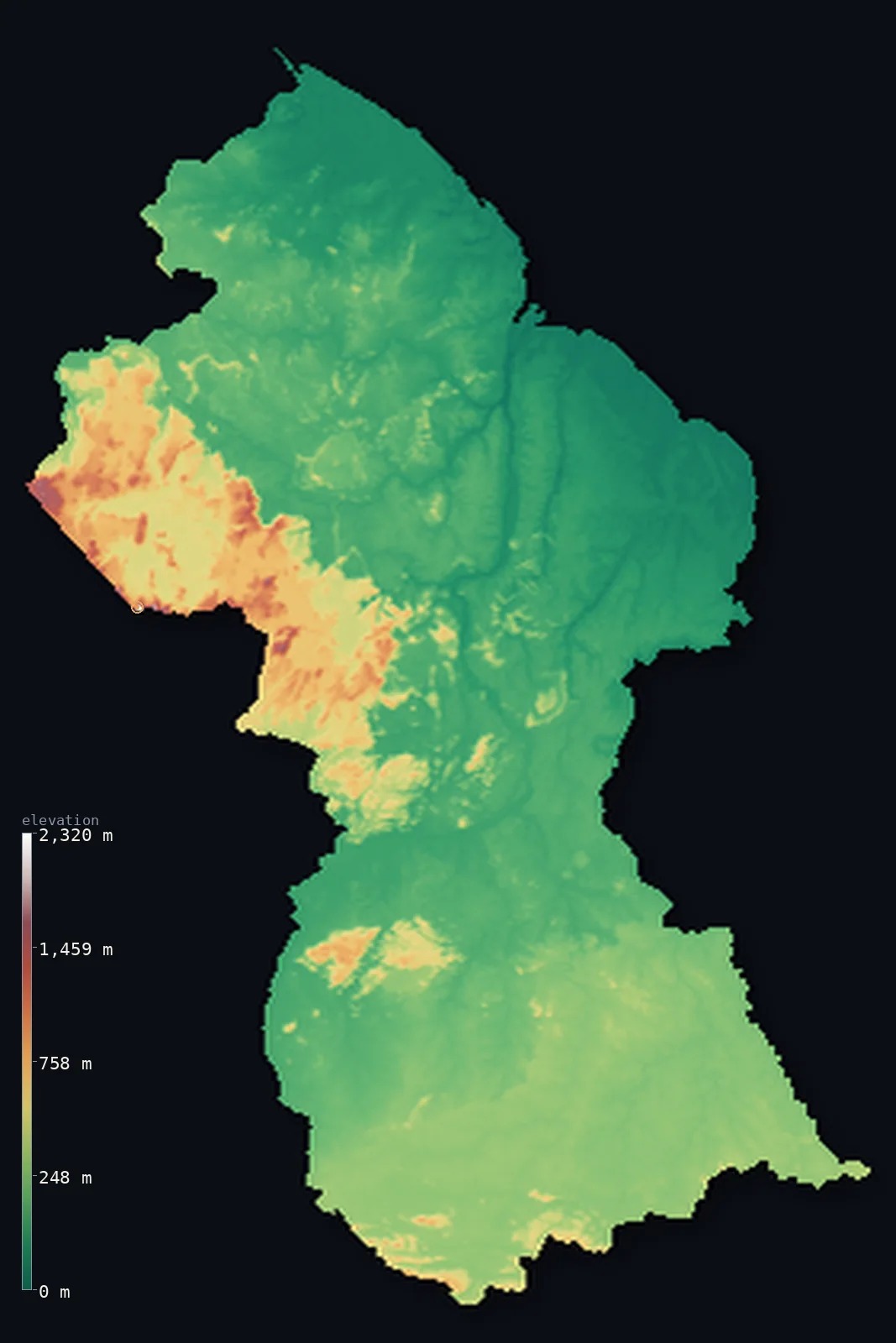
Guyana’s highest point is Mount Roraima (Guyana point) at 9,094 ft (2,772 m); its lowest is Atlantic Ocean at 0 ft (0 m); the mean elevation is 712 ft (217 m).
Guyana is a country of a low coast and a high, wild interior. Almost all its people live on a narrow Atlantic coastal plain in the north — flat, fertile, and so low that much of it lies at or below the level of the high tide, kept dry by a system of sea walls and canals built in the Dutch era. Inland, the land rises through dense rainforest — Guyana is one of the most forested countries on Earth — to the highlands of the Guiana Shield: rolling forested uplands, savannas, and, in the west, the dramatic flat-topped tepuis, including Mount Roraima, whose summit plateau at 9,094 ft (2,772 m) is the highest point in Guyana. So while the interior rises high, most people live at sea level: half the country lies below about 440 ft, in the coastal plain and the forested lowlands.
- Highest point📚
- 9,094 ft2,772 m
- Guyana's highest point is Mount Roraima, whose vast summit plateau reaches 9,094 ft (2,772 m) in the far west, where Guyana meets Venezuela and Brazil — one of the greatest of the tepuis, the great flat-topped sandstone table mountains of the Guiana Shield. Roraima is a sheer-walled island of rock rising above the forest and savanna, its top a strange, cloud-wrapped world of bare stone and endemic plants; the tripoint of the three countries lies on its summit, but the peak is Guyana's highest ground. (On the elevation model, the flat tepui rim reads a little lower than the surveyed summit, topping about 7,690 ft/2,344 m.)
- Lowest point📚
- 0 ft0 m
- Guyana's lowest point is the Atlantic coast at sea level — but much of the coastal plain where most Guyanese live actually lies below the level of the high tide, protected from the sea by walls and drained by canals. It is one of the few inhabited coasts that sits, in places, below the daily reach of the ocean.
- Mean elevation⚙
- 712 ft217 m
- Computed from the GLO-30 model, Guyana's mean elevation is 712 ft (217 m) — but the mean is lifted by the high interior highlands, for half the country lies below about 436 ft (133 m): the low coastal plain and the vast forested lowlands of the interior cover most of Guyana, while the tepuis and the highlands of the west and south, though high, are a minority of the land.
- Median elevation⚙
- 436 ft133 m
- Half of Guyana lies below about 436 ft (133 m) — a low figure, because the country is mostly low: the narrow coastal plain and, above all, the vast forested lowlands of the interior make up most of it, with the Guiana Shield highlands and the tepuis rising high only in the west and south.
- Elevation range📚
- 9,094 ft2,772 m
- From the Atlantic coast to the summit plateau of Mount Roraima at 2,772 m, Guyana's terrain climbs about 9,094 ft — from a coast that lies partly below the tide, across vast rainforest, to the sheer-walled tepuis of the Guiana Shield on the Venezuelan and Brazilian border.
- Above 1,000 m (3,281 ft)⚙
- 1%
- About 1% of Guyana rises above 1,000 m (3,281 ft) — only the higher parts of the Guiana Shield in the west and south, the tepuis and the Pakaraima and Kanuku mountains. The coastal plain and the vast forested interior lowlands lie far below.
- Official area📚
- 83,000 mi²214,969 km²
- Guyana covers about 83,000 sq mi (214,969 sq km) — a country on the northeast shoulder of South America, of a low Atlantic coastal plain (much of it below the tide) rising through vast rainforest to the highlands and tepuis of the Guiana Shield, including Mount Roraima on the Venezuelan and Brazilian border.
- Forest cover📚
- 93.6%
- About 94% of Guyana is forested — one of the most heavily forested countries on Earth, with dense tropical rainforest covering the vast interior, part of the great Guiana Shield forest, from the coastal lowlands to the slopes of the tepuis.
Highest and lowest points
Guyana's highest point is Mount Roraima, whose immense summit plateau reaches 9,094 ft (2,772 m) in the far west, at the point where Guyana, Venezuela, and Brazil meet. Roraima is the most famous of the tepuis — the flat-topped sandstone table mountains that rise sheer from the forests and savannas of the Guiana Shield, remnants of an ancient plateau worn away over hundreds of millions of years. Its vertical cliffs climb hundreds of metres to a bare, rain-lashed summit plateau of strange rock formations and plants found nowhere else, often wrapped in cloud — a landscape so otherworldly it inspired 'The Lost World.' The tripoint of the three countries lies on Roraima's summit, and while Venezuela's side of the massif holds even higher ground beyond the border, Roraima's plateau is the highest point within Guyana. (The flat tepui rim reads a little lower on the coarse elevation model than the surveyed summit — topping about 7,690 ft/2,344 m.) Elsewhere the Guiana Shield rises in the Pakaraima and Kanuku mountains, but Roraima is Guyana's roof.
source ↗Guyana's lowest point is the Atlantic Ocean at sea level — but the story of Guyana's coast is that much of it lies below the sea. The narrow coastal plain in the north, where the great majority of Guyanese live and farm, sits at or below the level of the high tide; it is kept dry only by a long system of sea walls, dikes, and drainage canals, first built when the Dutch controlled the coast, and still vital today. The capital, Georgetown, is among the coastal settlements that lie below high water. Inland from this low, protected coast, the land rises — gradually at first, through the vast rainforest that covers most of the country, and then, in the west and south, sharply, to the highlands of the Guiana Shield: the Pakaraima Mountains and the tepuis in the west, the Kanuku Mountains and the Rupununi savanna in the south. Guyana is a low country with a high, wild edge.
source ↗Guyana at a glance
Much of Guyana's coastal plain - where most of the population lives - lies below the level of the high tide, kept dry by sea walls and canals built in the Dutch era.
source ↗Guyana's highest point, Mount Roraima (2,772 m), is a giant flat-topped tepui on the Venezuela-Brazil border - its summit a sheer-walled world of bare rock and endemic plants that inspired 'The Lost World.'
source ↗Guyana is one of the most forested countries on Earth - dense rainforest of the Guiana Shield covers the vast interior.
source ↗Despite its high tepuis, most of Guyana is low - half the country lies below about 440 ft, in the coastal plain and the forested lowlands.
source ↗Kaieteur Falls, in central Guyana, is one of the world's most powerful single-drop waterfalls - plunging some 226 m in a single sheet in the heart of the rainforest.
source ↗The name 'Guyana' means 'land of many waters' - a country of great rivers (the Essequibo, Demerara, Berbice) flowing north from the highlands to the Atlantic.
source ↗
Elevation profile of Guyana
The largest share of land, 62%, falls in the 0–200 m band, and 88% of the territory lies below 500 m (1,640 ft).
- below 500 m (1,640 ft)88%
- 500–1,000 m11%
- 1,000–2,000 m1%
- above 2,000 m (6,562 ft)<1%
Highest peaks of Guyana
| Peak | Elevation | Range | Note |
|---|---|---|---|
| Mount Roraima (Guyana point)↗ | 9,094 ft2,772 m | Pakaraima Mountains (tripoint) | Highest point of Guyana, the northern corner of the Roraima tepui at the Venezuela-Brazil tripoint. |
| Mount Ayanganna↗ | 6,699 ft2,042 m | Pakaraima Mountains | A tepui in the Pakaraima range and one of Guyana's most prominent isolated tepuis. |
| Mount Wokomung↗ | 5,682 ft1,732 m | Pakaraima Mountains | A large tepui massif in the Pakaraima range of western Guyana. |
| Kanuku Mountains (high point)↗ | 3,281 ft1,000 m | Kanuku Mountains (south-central) | A forested range that bisects the Rupununi savanna in the south, reaching about 1,000 m. |
| Acarai Mountains (high point)↗ | 2,001 ft610 m | Acarai Mountains (Brazil border) | A low range along the southern border with Brazil, the divide toward the Amazon basin. |
Guyana: the coastal plain, the forested lowlands, and the highlands and tepuis
The coastal plain
A narrow strip of low, flat, fertile land along the Atlantic in the north — much of it at or below the level of the high tide, protected by sea walls and canals — where the great majority of Guyanese live and farm, including in the capital, Georgetown. The country's low, populous, sea-defended edge.
The forested lowlands and hills
Behind the coast, dense tropical rainforest covers most of the country — the vast interior of the Guiana Shield, rolling lowland and hill forest drained by great rivers. Low, green, and thinly peopled, it is the bulk of Guyana's area.
The highlands and tepuis (the west and south)
In the west and south the land rises to the highlands of the Guiana Shield — the Pakaraima Mountains and the great flat-topped tepuis (including Mount Roraima, the high point) in the west, and the Kanuku Mountains and Rupununi savanna in the south. The country's high, dramatic, wild interior edge.
How to read this map
Color shows elevation; the raised relief shows real terrain. On this map Guyana reads as a low country rising to a high western edge — the low green of the narrow coastal plain and the vast forested interior filling most of it, rising in the west and south to the browns of the Guiana Shield highlands, with the flat-topped tepuis (highest at Mount Roraima on the Venezuela-Brazil border) standing sheer above the forest.
The 3D relief is the actual GLO-30 elevation data, exaggerated vertically so the low lowlands and the high tepuis both show; the ×N relief slider controls how much. Tap anywhere to read that point's exact elevation.
City elevations in Guyana
Guyana's towns lie almost entirely on the coast — Georgetown, the capital, at the mouth of the Demerara on the Atlantic, and others like New Amsterdam and Linden along the coast and the lower rivers. Nearly everyone lives on the low coastal plain; the vast interior is almost empty.
| City | Population | Elevation |
|---|---|---|
| Georgetowncapitalthe capital, on the Atlantic coast at the Demerara mouth - below the high-tide line ↗ | 235,017 | 10 ft3 m |
| Lindenon the Demerara River inland ↗ | 44,690 | 3 ft1 m |
| New Amsterdamon the Berbice River, on the coast ↗ | 35,039 | 10 ft3 m |
| Anna Reginaon the Essequibo Coast, west of Georgetown ↗ | 12,448 | 7 ft2 m |
| Mabarumain the far northwest, near the Venezuelan border ↗ | 6,366 | 115 ft35 m |
| Mahdiaa mining town in the interior highlands ↗ | 4,200 | 282 ft86 m |
Elevation sampled at each city centre from the Copernicus GLO-30 model. Cities and population from GeoNames (CC-BY 4.0).
Guyana in comparison
Guyana's terrain rises 9,094 ft (2,772 m) from sea level to Mount Roraima (Guyana point) — about 31% of the height of Mount Everest, the world's highest point at 29,032 ft (8,849 m).
- Suriname's mean elevation is 515 ft — 197 ft lower; its high point, Julianatop, reaches 4,199 ft (1,280 m), 4,895 ft below. Suriname elevation map →
- Venezuela's mean elevation is 1,142 ft — 430 ft higher; its high point, Pico Bolívar, reaches 16,332 ft (4,978 m), 7,238 ft above. Venezuela elevation map →
- Brazil's mean elevation is 1,050 ft — 338 ft higher; its high point, Pico da Neblina, reaches 9,826 ft (2,995 m), 732 ft above. Brazil elevation map →
Frequently asked questions
What is the highest point in Guyana?
- Mount Roraima, whose summit plateau reaches 9,094 ft (2,772 m) on the Venezuela-Brazil border - one of the greatest of the tepuis, the great flat-topped table mountains of the Guiana Shield.
What is the lowest point in Guyana?
- The Atlantic coast at sea level - and much of the coastal plain, where most people live, actually lies below the high-tide line, kept dry by sea walls and canals.
What is the average elevation of Guyana?
- Computed from the Copernicus GLO-30 model, the area-weighted mean is 712 ft (217 m) - but this is lifted by the interior highlands; half the country lies below about 436 ft (133 m), in the low coastal plain and the forested lowlands.
Does Guyana lie below sea level?
- Much of its coastal plain does, in effect - it sits at or below the level of the high tide, protected by sea walls and drainage canals built in the Dutch era. That coast is where most of the population lives, including the capital, Georgetown.
What are the tepuis?
- Giant flat-topped sandstone table mountains of the Guiana Shield, rising sheer from the forest - Guyana's highest, Mount Roraima (2,772 m), is one of the greatest, a cloud-wrapped world of bare rock and unique plants.
Is this a topographic, relief, contour, or elevation map of Guyana?
- They describe the same thing - terrain height. This page renders the country's actual elevation surface in interactive 3D and reports the statistics computed from it.
About this map
The terrain is rendered from the Copernicus GLO-30 digital elevation model (ESA), masked to the GUY-ADM0 boundary from geoBoundaries (gbOpen). Elevation statistics are computed directly from the model; peak names and researched facts are sourced and cited. See the methodology for the full pipeline.
Our area-weighted mean, computed from the Copernicus GLO-30 model, is 712 ft (217 m); no authority publishes a mean elevation (the CIA World Factbook). Guyana's high country is in the interior — the tepuis and the Guiana Shield highlands of the west and south. But it is a minority of the land. Most of Guyana is low: the narrow coastal plain where nearly everyone lives, and the vast forested lowlands behind it, which cover the bulk of the country. So half of Guyana lies below about 436 ft (133 m). The high tepuis lift the average; the low forest is the country's true floor.
Surveyed national figures: official area · forest cover · high point.
Rendered from Copernicus GLO-30 (ESA, 2021 release), boundaries from geoBoundaries. Generated 2026-06-23.
Bordering countries · 3
Guyana shares a land border with these countries — open any one to compare its terrain and highest point.