Venezuela Elevation Map — Topographic & 3D Terrain
Explore the terrain of Venezuela in interactive 3D, built from Copernicus GLO-30 satellite elevation data — the tail of the Andes, the vast Orinoco plains, and the ancient table-mountains of the Guiana Highlands. Drag to rotate, scroll to zoom, and tap any point to read its elevation.
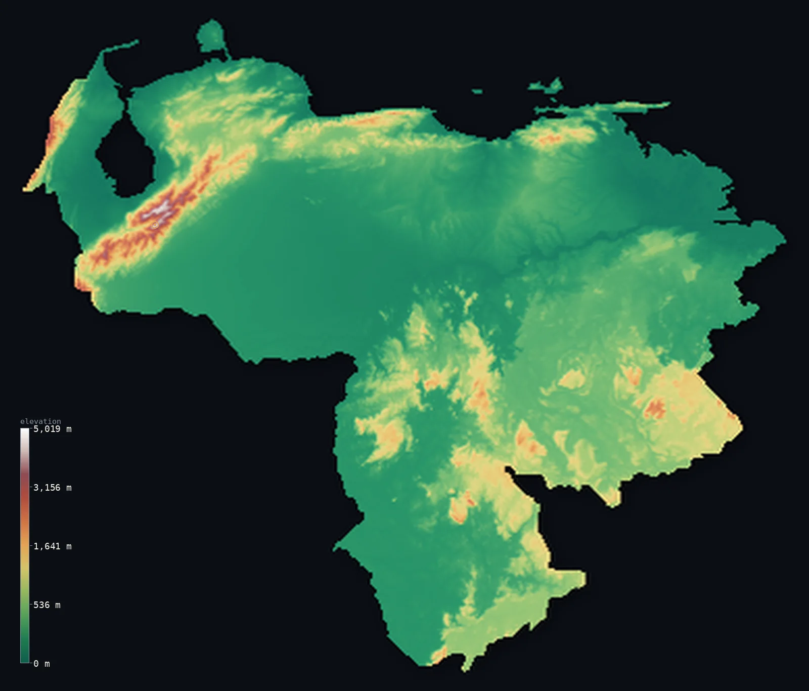
Venezuela’s highest point is Pico Bolívar at 16,332 ft (4,978 m); its lowest is Caribbean Sea at 0 ft (0 m); the mean elevation is 1,142 ft (348 m).
Venezuela packs three landscapes into one country. In the northwest the Andes make their final rise, carrying Pico Bolívar to 16,332 ft (4,978 m); across the centre spread the Llanos, the flat grassland plains of the Orinoco; and in the southeast lie the Guiana Highlands, where sheer-sided table mountains — the tepuis — stand above the jungle, one of them the source of the world's highest waterfall. Most of the country is low: about half lies below 522 ft (159 m).
- Highest point📚
- 16,332 ft4,978 m
- Venezuela's highest point is Pico Bolívar at 16,332 ft (4,978 m), in the Cordillera de Mérida — the final northeastern spur of the Andes before they sink into the Caribbean. It carried Venezuela's last glaciers until they vanished entirely in 2024, making Venezuela the first Andean country in modern times to lose all its glacial ice.
- Lowest point📚
- 0 ft0 m
- Venezuela's lowest point is the Caribbean Sea at sea level, along the northern coast — the low, hot shoreline of a country whose interior rises both to the Andes in the west and the ancient highlands of the south.
- Mean elevation⚙
- 1,142 ft348 m
- Computed from the GLO-30 model, Venezuela's mean elevation is 1,142 ft (348 m) — a modest figure, because most of the country is low: the Orinoco Llanos and the Maracaibo lowlands cover vast areas, with the height concentrated in the Andean northwest and the Guiana Highlands of the south.
- Median elevation⚙
- 522 ft159 m
- Half of Venezuela lies below 522 ft (159 m) — well under the mean, the signature of a country dominated by lowland: the flat Llanos of the Orinoco and the coastal plains make up most of it, while the Andes and the tepui highlands, though dramatic, cover a minority of the land.
- Elevation range📚
- 16,332 ft4,978 m
- From the Caribbean coast to the summit of Pico Bolívar, Venezuela spans about 16,330 ft — from sea-level shore through grassland plain and jungle to a glacierless Andean summit, with the tepuis of the south rising as a separate world of cliffs in between.
- Above 1,000 m (3,281 ft)⚙
- 8%
- About 8% of Venezuela rises above 1,000 m (3,281 ft) — the Cordillera de Mérida in the northwest, the coastal ranges near Caracas, and the higher tepuis of the Guiana Highlands. The great plains of the Orinoco between them are far lower.
- Above 2,000 m (6,562 ft)⚙
- 1%
- Roughly 1% of Venezuela stands above 2,000 m (6,562 ft) — the higher Cordillera de Mérida around Pico Bolívar and the loftier tepui summits of the Guiana Highlands.
- Official area📚
- 352,144 mi²912,050 km²
- Venezuela covers about 352,000 sq mi (912,050 sq km) — from the Andes and Lake Maracaibo in the northwest, across the Orinoco Llanos, to the Guiana Highlands of the south and east.
- Forest cover📚
- 52.6%
- About 52.6% of Venezuela is forested — extensive, from the rainforests of the Guiana Highlands and the Amazon south to the gallery forests threading the Llanos; the dry northwest and the open plains carry less.
Highest and lowest points
Venezuela's highest point is Pico Bolívar, 16,332 ft (4,978 m), in the Cordillera de Mérida — the last high spur of the Andes as they curve east into Venezuela before descending to the Caribbean. Until recently it held small glaciers, the last in the country; they disappeared entirely in 2024, and Venezuela became the first Andean country in modern times to lose all its glacial ice. The peak is named for Simón Bolívar and crowned with a bust of him, and rises above the city of Mérida in the Andean northwest.
source ↗Venezuela's lowest point is the Caribbean Sea at sea level, along a northern coast of beaches, headlands, and the great inlet of Lake Maracaibo — a large brackish lake connected to the sea, ringed by the country's oil fields, and lying in a hot lowland basin enclosed by mountains on three sides. The coast is the low edge of a country that rises sharply behind it, to the Andes in the west and the coastal cordillera above Caracas.
source ↗Venezuela at a glance
By 2024 Venezuela had lost its last glacier, becoming the first Andean country in modern times with no glaciers at all.
source ↗The Guiana Highlands of southeastern Venezuela hold the tepuis — sheer-sided table mountains of ancient sandstone, among the oldest exposed rock formations on Earth.
source ↗Angel Falls, dropping from the Auyán-tepui in the Guiana Highlands, is the highest uninterrupted waterfall in the world, falling about 979 m.
source ↗The Llanos — the vast flat grasslands of the Orinoco basin — cover much of central Venezuela, flooding in the wet season and drying to savanna in the dry.
source ↗Mount Roraima, the largest of the tepuis, is a tripoint where Venezuela, Brazil, and Guyana meet, its flat summit standing above the surrounding jungle.
source ↗Lake Maracaibo in the northwest, connected to the Caribbean, is one of the largest lakes in South America and lies in a hot lowland basin ringed by mountains.
source ↗
Elevation profile of Venezuela
The largest share of land, 77%, falls in the 0–500 m band, and 78% of the territory lies below 500 m (1,640 ft).
- below 500 m (1,640 ft)78%
- 500–1,000 m14%
- 1,000–2,000 m7%
- above 2,000 m (6,562 ft)1%
Highest peaks of Venezuela
| Peak | Elevation | Range | Note |
|---|---|---|---|
| Pico Bolívar↗ | 16,332 ft4,978 m | Cordillera de Merida (Andes) | Highest point of Venezuela, in the Sierra Nevada de Merida. |
| Pico Humboldt↗ | 16,207 ft4,940 m | Cordillera de Merida (Andes) | The second-highest peak in Venezuela; its Humboldt Glacier, the country's last, vanished in 2024. |
| Pico La Concha↗ | 16,142 ft4,920 m | Cordillera de Merida (Andes) | The third-highest of the Merida peaks, beside Bolivar and Humboldt. |
| Pico Bonpland↗ | 16,020 ft4,883 m | Cordillera de Merida (Andes) | A high summit of the Sierra Nevada de Merida, near Pico Humboldt. |
| Mount Roraima↗ | 9,219 ft2,810 m | Guiana Highlands (tepui) | The most famous tepui, a flat-topped table mountain at the triple border with Brazil and Guyana. |
The Andes, the Llanos, and the tepui highlands
The Venezuelan Andes and the northwest
In the northwest the Andes make their final rise as the Cordillera de Mérida, carrying Pico Bolívar, the country's high point. Beyond them lies the Maracaibo basin — a hot lowland around the great lake, enclosed by mountains and rich in oil — and the dry ranges reaching toward the Caribbean.
The Llanos (Orinoco plains)
Across the centre of the country spread the Llanos — immense flat grasslands drained by the Orinoco and its tributaries, flooding in the rains and baking in the dry season. Low, level, and open, they are the country's agricultural heart and much of its statistical bulk.
The Guiana Highlands and the tepuis
South and east of the Orinoco rise the Guiana Highlands — an ancient plateau of some of the oldest rock on Earth, from which the tepuis stand up as sheer-walled table mountains. Auyán-tepui launches Angel Falls, the world's highest waterfall; Roraima marks the Brazil-Guyana border. A landscape of cliffs, jungle, and isolation.
The Caribbean coast and coastal range
Along the north, a coastal mountain range rises steeply just inland from the Caribbean, holding Caracas in its valleys — the most densely settled part of the country — above a shore of beaches and headlands.
How to read this map
Color shows elevation; the raised relief shows real terrain. On this map Venezuela reads in three parts — the high brown-and-white Andes gathered in the northwest, the broad low green of the Orinoco Llanos across the centre, and the raised, cliff-edged plateau of the Guiana Highlands in the south and east where the tepuis stand.
The 3D relief is the actual GLO-30 elevation data, exaggerated vertically so the Andes, the plains, and the table-mountains all show; the ×N relief slider controls how much. Tap anywhere to read that point's exact elevation.
City elevations in Venezuela
Venezuela's cities cluster in the north — Caracas in the coastal range, Maracaibo and Valencia in the northwestern lowlands, Barquisimeto toward the Andes — with Ciudad Guayana on the Orinoco at the edge of the highlands. The southern highlands and the Llanos hold few large cities.
| City | Population | Elevation |
|---|---|---|
| Caracascapitalthe capital, in a valley of the coastal range near the Caribbean ↗ | 3,000,000 | 2,913 ft888 m |
| Maracaiboon the strait of Lake Maracaibo in the northwestern lowlands, centre of the oil industry ↗ | 1,752,602 | 20 ft6 m |
| Valencia | 1,619,470 | 1,496 ft456 m |
| Barquisimeto | 1,240,714 | 1,969 ft600 m |
| Ciudad Guayanaon the Orinoco in the southeast, at the edge of the Guiana Highlands ↗ | 978,202 | 335 ft102 m |
| Barcelona | 815,141 | 16 ft5 m |
| Maturín | 647,459 | 226 ft69 m |
| Barinas | 397,279 | 636 ft194 m |
| San Cristóbal | 289,852 | 2,684 ft818 m |
| Coro | 246,657 | 72 ft22 m |
Elevation sampled at each city centre from the Copernicus GLO-30 model. Cities and population from GeoNames (CC-BY 4.0).
Venezuela in comparison
Venezuela's terrain rises 16,332 ft (4,978 m) from sea level to Pico Bolívar — about 56% of the height of Mount Everest, the world's highest point at 29,032 ft (8,849 m).
- Colombia's mean elevation is 1,834 ft — 692 ft higher; its high point, Pico Cristóbal Colón, reaches 18,947 ft (5,775 m), 2,615 ft above. Colombia elevation map →
- Guyana's mean elevation is 712 ft — 430 ft lower; its high point, Mount Roraima (Guyana point), reaches 9,094 ft (2,772 m), 7,238 ft below. Guyana elevation map →
- Brazil's mean elevation is 1,050 ft — 92 ft lower; its high point, Pico da Neblina, reaches 9,826 ft (2,995 m), 6,506 ft below. Brazil elevation map →
Frequently asked questions
What is the highest point in Venezuela?
- Pico Bolívar, 16,332 ft (4,978 m), in the Cordillera de Mérida of the northwestern Andes — it held the country's last glaciers until they vanished in 2024.
What is the lowest point in Venezuela?
- The Caribbean Sea at sea level, along the northern coast.
What is the average elevation of Venezuela?
- Computed from the Copernicus GLO-30 model, the area-weighted mean is 1,142 ft (348 m) — modest, because the Orinoco Llanos and the coastal lowlands cover most of the country, with the height in the Andes and the southern highlands.
What are the tepuis?
- The sheer-sided table mountains of the Guiana Highlands in southeastern Venezuela — ancient sandstone plateaus rising abruptly above the jungle. Auyán-tepui is the source of Angel Falls, the world's highest waterfall, and Roraima marks the Brazil-Guyana border.
Does Venezuela have glaciers?
- No longer — the last glaciers, on Pico Bolívar, disappeared in 2024, making Venezuela the first Andean country in modern times to lose all its glacial ice.
Is this a topographic, relief, contour, or elevation map of Venezuela?
- They describe the same thing — terrain height. This page renders the country's actual elevation surface in interactive 3D and reports the statistics computed from it.
About this map
The terrain is rendered from the Copernicus GLO-30 digital elevation model (ESA), masked to the VEN-ADM0 boundary from geoBoundaries (gbOpen). Elevation statistics are computed directly from the model; peak names and researched facts are sourced and cited. See the methodology for the full pipeline.
Our area-weighted mean, computed from the Copernicus GLO-30 model, is 1,142 ft (348 m); the figure commonly cited elsewhere is 1,476 ft (450 m) (CIA World Factbook). Venezuela mixes very high and very low ground - the Andes and the Guiana Highlands against the vast low Llanos and the Maracaibo basin - giving a moderate mean; the page reports the area-weighted figure computed from the Copernicus GLO-30 model.
Surveyed national figures: official area · forest cover · high point.
Rendered from Copernicus GLO-30 (ESA, 2021 release), boundaries from geoBoundaries. Generated 2026-07-08.
Bordering countries · 3
Venezuela shares a land border with these countries — open any one to compare its terrain and highest point.