Colombia Elevation Map — Topographic & 3D Terrain
Explore the terrain of Colombia in interactive 3D, built from Copernicus GLO-30 satellite elevation data — where the Andes split into three ranges and the highest peak stands by the sea. Drag to rotate, scroll to zoom, and tap any point to read its elevation.
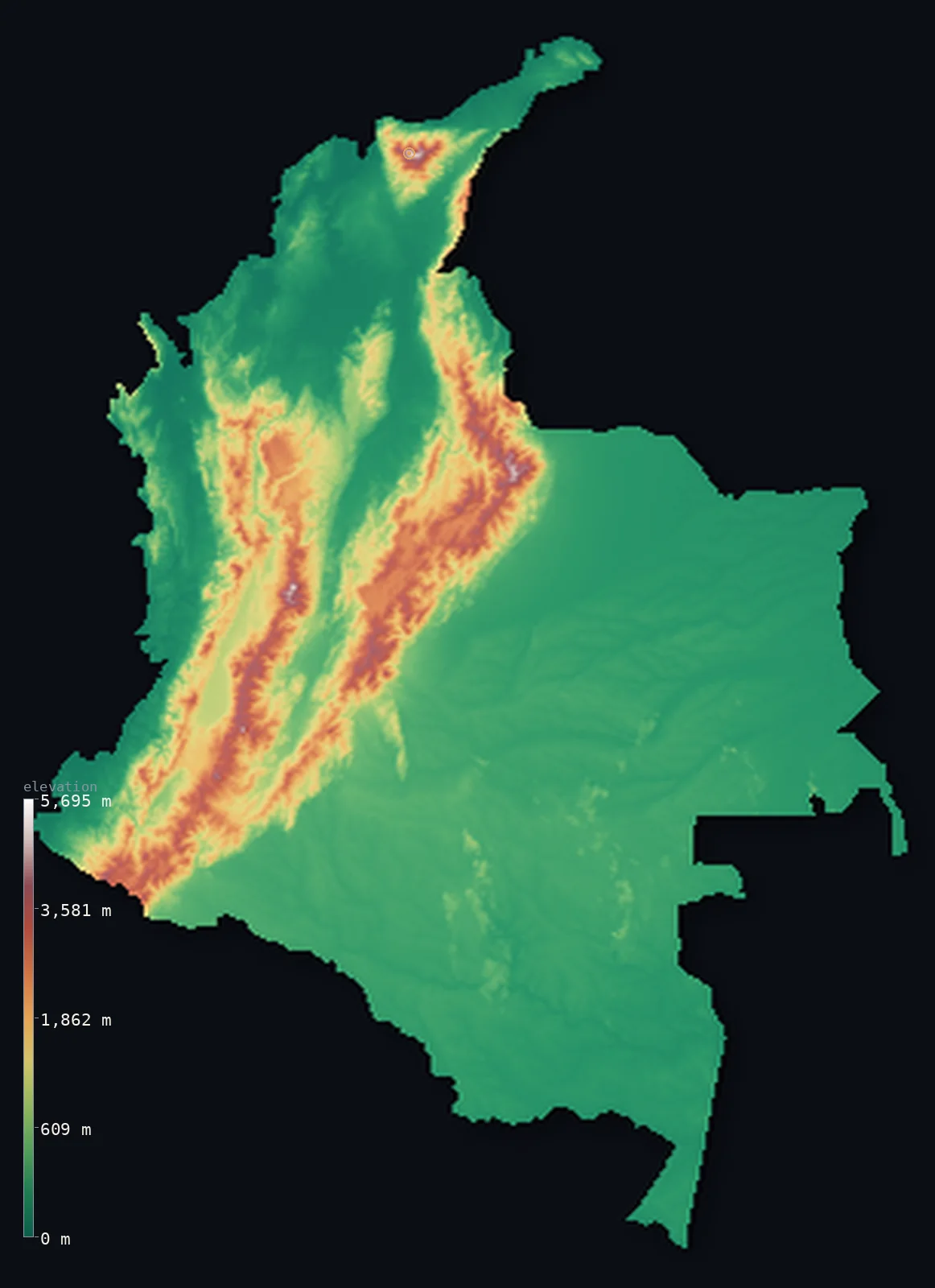
Colombia’s highest point is Pico Cristóbal Colón at 18,947 ft (5,775 m); its lowest is Pacific Ocean / Caribbean Sea at 0 ft (0 m); the mean elevation is 1,834 ft (559 m).
Colombia is where the Andes come apart. Entering from the south as a single range, the mountains split into three separate cordilleras running north with broad river valleys between them — and then, oddly, the country's highest peak stands somewhere else entirely: Pico Cristóbal Colón, 18,947 ft (5,775 m), rises from the Caribbean coast in an isolated massif that is not part of the Andes at all. Beyond the mountains, three-quarters of Colombia is low: the Llanos and the Amazon fill the east.
- Highest point📚
- 18,947 ft5,775 m
- Colombia's highest point is Pico Cristóbal Colón at 18,947 ft (5,775 m) — and it is not in the Andes. It stands in the Sierra Nevada de Santa Marta, an isolated pyramid of a massif rising straight from the Caribbean shore, among the highest coastal mountains on Earth.
- Lowest point📚
- 0 ft0 m
- Colombia's lowest point is sea level — and uniquely in South America, it reaches two oceans, with coastlines on both the Caribbean and the Pacific.
- Mean elevation⚙
- 1,834 ft559 m
- Colombia's mean elevation computed from the GLO-30 model is 1,834 ft (559 m) — the lowest of the Andean countries, because the mountains occupy only the country's western third while the vast Llanos and Amazon lowlands fill everything east of them.
- Median elevation⚙
- 643 ft196 m
- Half of Colombia lies below just 643 ft (196 m) — remarkably low for a country with 5,000-metre peaks, and the plainest measure of its shape: three mountain ranges packed into the west, and an enormous flat expanse of plain and rainforest making up the rest.
- Elevation range📚
- 18,947 ft5,775 m
- From sea level to Pico Cristóbal Colón, Colombia spans about 18,900 ft — and the whole climb happens twice, once in the Andean west and again, abruptly, in the coastal massif that carries the summit.
- Above 1,000 m (3,281 ft)⚙
- 18%
- Only about 18% of Colombia rises above 1,000 m (3,281 ft) — the three cordilleras and the Santa Marta massif. Everything else, three-quarters of the country, lies below 500 m.
- Above 2,000 m (6,562 ft)⚙
- 9%
- Roughly 9% of Colombia stands above 2,000 m (6,562 ft), and under 3% above 3,000 m — a small share of the land, but it holds Bogotá and much of the population, farming and living on the high plateaus between the ranges.
- Official area📚
- 440,831 mi²1,141,748 km²
- Colombia covers about 440,831 sq mi (1,141,748 sq km) — the only South American country with coasts on both the Caribbean and the Pacific, spanning three Andean ranges, two great river valleys, and a share of both the Llanos and the Amazon.
- Forest cover📚
- 52.7%
- About 53% of Colombia is forested — Amazon rainforest across the southeast, cloud forest on the cordillera slopes, and the extraordinarily wet forests of the Chocó along the Pacific coast, among the rainiest places on Earth.
Highest and lowest points
Colombia's highest point is Pico Cristóbal Colón, 18,947 ft (5,775 m), and its location is the surprise: it is not in the Andes but in the Sierra Nevada de Santa Marta, an isolated triangular massif on the Caribbean coast that rises from sea level to snow within about 45 km — among the highest coastal mountain ranges anywhere. Its twin summit, Pico Simón Bolívar, is essentially the same height. On this elevation model the glaciated crest reads slightly lower than the surveyed figure shown above.
source ↗Colombia's lowest point is sea level, and it is the only country in South America to reach two oceans — the Caribbean in the north and the Pacific in the west. The two coasts could hardly be more different: the Caribbean shore is dry and populous, backed by the abrupt Santa Marta massif, while the Pacific Chocó is dense, roadless rainforest and one of the wettest places on the planet.
source ↗Colombia at a glance
Colombia's highest peak, Pico Cristóbal Colón (5,775 m), is not in the Andes - it rises from the Caribbean coast in the isolated Sierra Nevada de Santa Marta, going from sea level to snow in about 45 km.
source ↗The Andes split into three separate cordilleras as they enter Colombia, with the broad Cauca and Magdalena river valleys running between them.
source ↗Colombia is the only South American country with coastline on both the Caribbean Sea and the Pacific Ocean.
source ↗Three-quarters of Colombia lies below 500 m - the Llanos grasslands and the Amazon rainforest fill the entire east of the country.
source ↗Bogotá sits at about 2,580 m on a high Andean plateau, one of the highest capital cities in the world.
source ↗The Chocó region on Colombia's Pacific coast is one of the wettest places on Earth, receiving many metres of rain a year.
source ↗
Elevation profile of Colombia
The largest share of land, 75%, falls in the 0–500 m band, and 75% of the territory lies below 500 m (1,640 ft).
- below 500 m (1,640 ft)75%
- 500–1,000 m6%
- 1,000–2,000 m9%
- above 2,000 m (6,562 ft)9%
Highest peaks of Colombia
| Peak | Elevation | Range | Note |
|---|---|---|---|
| Pico Cristóbal Colón↗ | 18,947 ft5,775 m | Sierra Nevada de Santa Marta | Highest point of Colombia, an isolated snowcapped massif on the Caribbean coast — not part of the Andes. |
| Pico Simón Bolívar↗ | 18,947 ft5,775 m | Sierra Nevada de Santa Marta | The near-twin of Cristóbal Colón, almost exactly equal in height; the two are Colombia's highest summits. |
| Pico Santander (Cordillera Oriental)↗ | 18,278 ft5,571 m | Cordillera Oriental (Andes) | A high glaciated peak of the Sierra Nevada del Cocuy in the eastern cordillera. |
| Nevado del Huila↗ | 17,598 ft5,364 m | Cordillera Central (Andes) | The highest peak of the Colombian Andes and the country's highest volcano, in the central cordillera. |
| Nevado del Ruiz↗ | 17,425 ft5,311 m | Cordillera Central (Andes) | An active glacier-capped volcano of the central cordillera, whose 1985 eruption was one of the deadliest of the 20th century. |
Colombia's four landscapes
The three cordilleras
The Andes enter Colombia from the south and immediately split into three parallel ranges — the Cordillera Occidental, Central, and Oriental — running north with the deep Cauca and Magdalena valleys between them. The Central is the highest and volcanic; the Oriental carries the plateau where Bogotá stands.
The Sierra Nevada de Santa Marta
Separate from the Andes entirely, this isolated massif rises on the Caribbean coast to Pico Cristóbal Colón, Colombia's highest point — climbing from tropical beach to permanent snow in about 45 km, one of the steepest coastal rises on Earth.
The two coasts
Colombia meets both the Caribbean and the Pacific. The northern coast is drier and holds the country's great port cities; the Pacific side, the Chocó, is dense rainforest and among the rainiest regions in the world.
The Llanos and the Amazon
East of the mountains, three-quarters of Colombia is lowland — the flat Llanos grasslands along the Orinoco in the northeast, and the Amazon rainforest in the south. Vast, low, and thinly populated, they make up most of the country's area.
How to read this map
Color shows elevation; the raised relief shows real terrain. On this map Colombia reads as three parallel brown ridges in the west, an isolated white peak on the Caribbean shore, and a great flat green expanse filling the east.
The 3D relief is the actual GLO-30 elevation data, exaggerated vertically so the split cordilleras and the coastal massif both stand out; the ×N relief slider controls how much. Tap anywhere to read that point's exact elevation.
City elevations in Colombia
Colombia's cities sit high in the mountains or low on the coast, with little in between — Bogotá on its Andean plateau at about 8,500 ft, and the Caribbean ports at sea level. The pattern follows the cordilleras: most of the population lives up in the western third of the country.
| City | Population | Elevation |
|---|---|---|
| Bogotácapitalthe capital, on a high plateau of the Cordillera Oriental at about 2,580 m ↗ | 7,674,366 | 8,478 ft2,584 m |
| Cali | 2,392,877 | 3,156 ft962 m |
| Medellín | 1,999,979 | 4,836 ft1,474 m |
| Barranquilla | 1,206,319 | 62 ft19 m |
| Cúcuta | 777,106 | 991 ft302 m |
| Ibagué | 529,635 | 3,720 ft1,134 m |
| Montería | 490,935 | 59 ft18 m |
| Valledupar | 490,075 | 561 ft171 m |
| Pasto | 392,930 | 8,314 ft2,534 m |
| Neiva | 357,392 | 1,503 ft458 m |
Elevation sampled at each city centre from the Copernicus GLO-30 model. Cities and population from GeoNames (CC-BY 4.0).
Colombia in comparison
Colombia's terrain rises 18,947 ft (5,775 m) from sea level to Pico Cristóbal Colón — about 65% of the height of Mount Everest, the world's highest point at 29,032 ft (8,849 m).
- Ecuador's mean elevation is 3,530 ft — 1,696 ft higher; its high point, Chimborazo, reaches 20,548 ft (6,263 m), 1,601 ft above. Ecuador elevation map →
- Venezuela's mean elevation is 1,142 ft — 692 ft lower; its high point, Pico Bolívar, reaches 16,332 ft (4,978 m), 2,615 ft below. Venezuela elevation map →
- Peru's mean elevation is 4,810 ft — 2,976 ft higher; its high point, Huascaran, reaches 22,205 ft (6,768 m), 3,258 ft above. Peru elevation map →
Frequently asked questions
What is the highest point in Colombia?
- Pico Cristóbal Colón, 18,947 ft (5,775 m) - and it is not in the Andes. It stands in the isolated Sierra Nevada de Santa Marta on the Caribbean coast.
What is the lowest point in Colombia?
- Sea level - Colombia is the only South American country with coastline on both the Caribbean and the Pacific.
What is the average elevation of Colombia?
- Computed from the Copernicus GLO-30 model, the area-weighted mean is 1,834 ft (559 m) - the lowest of the Andean countries, since three-quarters of Colombia is eastern lowland.
Why does Colombia have three mountain ranges?
- The Andes split as they enter Colombia from the south into three separate cordilleras - Occidental, Central, and Oriental - divided by the Cauca and Magdalena river valleys.
How high is Bogotá?
- About 2,580 m on a plateau of the Cordillera Oriental, making it one of the highest capital cities in the world.
Is this a topographic, relief, contour, or elevation map of Colombia?
- They describe the same thing - terrain height. This page renders the country's actual elevation surface in interactive 3D and reports the statistics computed from it.
About this map
The terrain is rendered from the Copernicus GLO-30 digital elevation model (ESA), masked to the COL-ADM0 boundary from geoBoundaries (gbOpen). Elevation statistics are computed directly from the model; peak names and researched facts are sourced and cited. See the methodology for the full pipeline.
Our area-weighted mean, computed from the Copernicus GLO-30 model, is 1,834 ft (559 m); the figure commonly cited elsewhere is 1,946 ft (593 m) (CIA World Factbook). Colombia splits between the high Andes and the snowcapped Sierra Nevada in the west and north and the vast low plains of the Orinoco and Amazon in the east and south, so the mean elevation is moderate even though its peaks exceed 5,700 m; the page reports the area-weighted figure computed from the Copernicus GLO-30 model.
Surveyed national figures: official area · forest cover · high point.
Rendered from Copernicus GLO-30 (ESA, 2021 release), boundaries from geoBoundaries. Generated 2026-06-22.
Bordering countries · 5
Colombia shares a land border with these countries — open any one to compare its terrain and highest point.