Ecuador Elevation Map — Topographic & 3D Terrain
Explore the terrain of Ecuador in interactive 3D, built from Copernicus GLO-30 satellite elevation data — the volcanic Andes between the Pacific coast and the Amazon, on the equator. Drag to rotate, scroll to zoom, and tap any point to read its elevation.
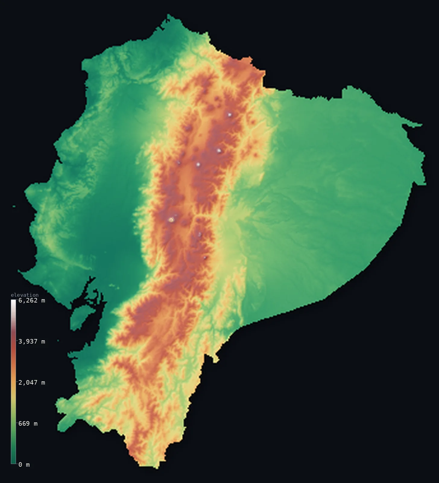
Ecuador’s highest point is Chimborazo at 20,548 ft (6,263 m); its lowest is Pacific Ocean at 0 ft (0 m); the mean elevation is 3,530 ft (1,076 m).
Ecuador is a small country of three worlds, split by the Andes on the equator. Down its centre run two great volcanic ranges of the Andes — the Sierra — a double row of high peaks and volcanoes enclosing a string of high basins, including some of the highest active volcanoes on Earth: Cotopaxi, and Chimborazo, which at 20,548 ft (6,263 m) is the highest point in Ecuador. But the high Andes are a central band: to the west lies the Costa, a low, hot Pacific coastal lowland, and to the east the Oriente, the vast, low Amazon rainforest — and together these lowlands make up most of the country. So while the volcanic Sierra holds much of the population and all of Ecuador's great peaks, more than half the country lies below about 1,250 ft, in the coastal and Amazon lowlands. (Ecuador's Galápagos Islands lie far offshore in the Pacific and are mapped separately.)
- Highest point📚
- 20,548 ft6,263 m
- Ecuador's highest point is Chimborazo at 20,548 ft (6,263 m), a giant dormant volcano in the western range of the Andes. Because the Earth bulges at the equator, and Chimborazo sits almost on the equator, its summit is the farthest point on the Earth's surface from the planet's centre — farther out than the peak of Everest. It is the highest of Ecuador's many great volcanoes, rising far above the high basins of the Sierra, and its top carries permanent snow and ice despite lying in the tropics.
- Lowest point📚
- 0 ft0 m
- Ecuador's lowest point is the Pacific Ocean at sea level, along the Costa — the low, hot western coastal lowland of plains, rivers, and mangroves. From this coast the land rises eastward into the high Andes, then falls again into the Amazon.
- Mean elevation⚙
- 3,530 ft1,076 m
- Computed from the GLO-30 model, Ecuador's mean elevation is 3,530 ft (1,076 m) — but Ecuador is three worlds, and two of them are low: the Pacific Costa in the west and the Amazon Oriente in the east cover most of the country and set the median at 1,250 ft (381 m), far below the mean. Only the volcanic Sierra down the centre stands high, and it is the mean, not the median, that its great peaks inflate.
- Median elevation⚙
- 1,250 ft381 m
- Half of Ecuador lies below about 1,250 ft (381 m) — low, because the country's two great lowlands, the Pacific coast and the Amazon, cover more ground than the Andes between them. The high Sierra holds the volcanoes and much of the population, but it is a band down the middle, not the bulk of Ecuador.
- Elevation range📚
- 20,548 ft6,263 m
- From the Pacific coast to the summit of Chimborazo at 6,263 m, Ecuador's terrain climbs about 20,548 ft — the full sweep from a tropical sea-level coast, up through the volcanic Andes to the farthest point from the Earth's centre, and down again to the Amazon: three worlds in one small country.
- Above 1,000 m (3,281 ft)⚙
- 36%
- About 36% of Ecuador rises above 1,000 m (3,281 ft) — the high Andes down the centre, the double range of the Sierra with its volcanoes and high basins. The Pacific Costa in the west and the Amazon Oriente in the east lie below.
- Above 2,000 m (6,562 ft)⚙
- 23%
- Roughly 23% of Ecuador stands above 2,000 m (6,562 ft) — the high Sierra, the volcanic ranges and the high inter-Andean basins, the country's high, populous heart.
- Official area📚
- 109,483 mi²283,561 km²
- Ecuador covers about 109,500 sq mi (283,561 sq km) — a small equatorial country of three regions: the low Pacific Costa in the west, the high volcanic Andes (the Sierra, holding Chimborazo, the farthest point from the Earth's centre) down the middle, and the low Amazon Oriente in the east — with the Galápagos Islands far offshore in the Pacific.
- Forest cover📚
- 50.5%
- About 51% of Ecuador is forested — vast Amazon rainforest across the eastern Oriente, tropical forest and drier plains on the western coast, and páramo grassland and cloud forest on the high Andean slopes.
Highest and lowest points
Ecuador's highest point is Chimborazo, 20,548 ft (6,263 m), a massive dormant volcano in the western range of the Ecuadorean Andes. It holds a singular distinction: because the Earth is not a perfect sphere but bulges at the equator, and because Chimborazo stands almost on the equator, the summit of Chimborazo is the point on the Earth's surface farthest from the centre of the planet — farther from the Earth's core than the summit of Mount Everest, even though Everest is far higher above sea level. Chimborazo is the greatest of Ecuador's volcanoes, which run in a double file down the Sierra — the 'Avenue of the Volcanoes' — including the perfect cone of Cotopaxi, one of the highest active volcanoes in the world, and Tungurahua and others, several of them active. Chimborazo itself is snow-capped and dormant, rising high above the inter-Andean basins where much of Ecuador's population lives.
source ↗Ecuador's lowest point is the Pacific Ocean at sea level, along the Costa — the low, hot, fertile coastal lowland that runs the length of the country's western side, a land of banana and cacao plantations, broad rivers, and mangroves, holding the great port of Guayaquil. From this coast the land climbs eastward, and fast, into the Andes — the Sierra, a double row of high volcanic ranges enclosing a chain of high basins, the 'Avenue of the Volcanoes.' Beyond the mountains the land falls away again, eastward, into the Oriente: the vast, low, wet Amazon rainforest, drained by the headwaters of the Amazon River, stretching toward Peru and Brazil. And far out in the Pacific, some 1,000 km west of the mainland, lie the Galápagos Islands — Ecuadorean, volcanic, and mapped separately from the country's mainland shown here. Three worlds, split by the mountains.
source ↗Ecuador at a glance
The summit of Chimborazo (6,263 m) in Ecuador is the farthest point on the Earth's surface from the planet's centre - farther out than Everest - because the Earth bulges at the equator, where Chimborazo stands.
source ↗Ecuador is a country of three worlds - the low Pacific Costa, the high volcanic Andes (the Sierra), and the low Amazon Oriente - split by the mountains on the equator.
source ↗Despite its Andes, Ecuador is mostly low - more than half the country lies below about 1,250 ft, in the coastal and Amazon lowlands, with the high Sierra a densely populated central band.
source ↗Ecuador's Sierra is called the 'Avenue of the Volcanoes' - a double row of high volcanic peaks, including Cotopaxi, one of the highest active volcanoes on Earth.
source ↗The Galápagos Islands, about 1,000 km west of the mainland in the Pacific, are part of Ecuador - volcanic islands famous for the wildlife that inspired Darwin.
source ↗Ecuador takes its name from the equator, which crosses the country just north of the capital, Quito - the second-highest capital city in the world.
source ↗
Elevation profile of Ecuador
The largest share of land, 55%, falls in the 0–500 m band, with the land split almost evenly above and below 500 m (1,640 ft).
- below 500 m (1,640 ft)55%
- 500–1,000 m9%
- 1,000–2,000 m14%
- above 2,000 m (6,562 ft)23%
Highest peaks of Ecuador
| Peak | Elevation | Range | Note |
|---|---|---|---|
| Chimborazo↗ | 20,548 ft6,263 m | Cordillera Occidental (Andes) | Highest point of Ecuador and the farthest point on Earth's surface from the planet's centre. |
| Cotopaxi↗ | 19,347 ft5,897 m | Cordillera Oriental (Andes) | One of the world's highest active volcanoes, a near-perfect cone visible from Quito. |
| Cayambe↗ | 18,996 ft5,790 m | Cordillera Oriental (Andes) | The only point on the Equator covered in snow and glacier ice. |
| Antisana↗ | 18,714 ft5,704 m | Cordillera Oriental (Andes) | A glaciated volcano east of Quito, feeding much of the capital's water supply. |
| Tungurahua↗ | 16,480 ft5,023 m | Cordillera Oriental (Andes) | An active volcano above the town of Banos, long in frequent eruption. |
Ecuador: the Pacific Costa, the volcanic Sierra, and the Amazon Oriente
The Costa (the Pacific lowland)
Western Ecuador is the Costa — a low, hot coastal lowland of plains, broad rivers, plantations, and mangroves, holding the great port of Guayaquil. Low, fertile, and populous, it is one of the country's two great lowlands.
The Sierra (the volcanic Andes)
Down the centre run the Andes — the Sierra, a double row of high volcanic ranges enclosing a chain of high basins (the 'Avenue of the Volcanoes'), holding Chimborazo (the high point and farthest point from the Earth's centre), Cotopaxi, and the capital, Quito. High, volcanic, and densely settled, it is the country's central spine.
The Oriente (the Amazon)
Eastern Ecuador is the Oriente — the vast, low, wet Amazon rainforest, drained by the headwaters of the Amazon and stretching toward Peru and Brazil. Low, green, and thinly peopled, it is the country's largest and wildest region.
How to read this map
Color shows elevation; the raised relief shows real terrain. On this map Ecuador reads as three bands — the low green of the Pacific Costa in the west, rising sharply to the high browns and whites of the volcanic Andes down the centre (the double range of the Sierra, highest at Chimborazo, with the line of great volcanoes), and falling again to the low green of the Amazon Oriente in the east. (The Galápagos, far offshore, are mapped separately.)
The 3D relief is the actual GLO-30 elevation data, exaggerated vertically so the low lowlands and the high volcanoes both show; the ×N relief slider controls how much. Tap anywhere to read that point's exact elevation.
City elevations in Ecuador
Ecuador's cities split between the coast and the mountains — Guayaquil, the largest, a port on the Pacific lowland, Quito, the capital, high in an Andean basin (the second-highest capital in the world), Cuenca in the southern Sierra, and others. The coast and the highlands each hold great cities.
| City | Population | Elevation |
|---|---|---|
| Quitocapitalthe capital, high in an Andean basin - the second-highest capital in the world ↗ | 2,781,641 | 9,383 ft2,860 m |
| Guayaquilthe largest city, a Pacific port on the coastal lowland ↗ | 2,723,665 | 36 ft11 m |
| Cuencain the southern Andean highlands ↗ | 636,996 | 8,310 ft2,533 m |
| Santo Domingo de los Coloradosin the western foothills, toward the coast ↗ | 458,580 | 1,801 ft549 m |
| Ambatoin the central Andean Sierra ↗ | 387,309 | 8,530 ft2,600 m |
| Portoviejoon the coastal plain (Manabí) ↗ | 321,800 | 138 ft42 m |
| Machalaa Pacific port in the south, in banana country ↗ | 289,141 | 46 ft14 m |
| Lojain the far southern Andean highlands ↗ | 274,112 | 6,762 ft2,061 m |
| Ibarrain the northern Andean highlands ↗ | 221,149 | 7,238 ft2,206 m |
| Esmeraldasa Pacific port on the north coast ↗ | 218,727 | 52 ft16 m |
Elevation sampled at each city centre from the Copernicus GLO-30 model. Cities and population from GeoNames (CC-BY 4.0).
Ecuador in comparison
Ecuador's terrain rises 20,548 ft (6,263 m) from sea level to Chimborazo — about 71% of the height of Mount Everest, the world's highest point at 29,032 ft (8,849 m).
- Colombia's mean elevation is 1,834 ft — 1,696 ft lower; its high point, Pico Cristóbal Colón, reaches 18,947 ft (5,775 m), 1,601 ft below. Colombia elevation map →
- Peru's mean elevation is 4,810 ft — 1,280 ft higher; its high point, Huascaran, reaches 22,205 ft (6,768 m), 1,657 ft above. Peru elevation map →
- Bolivia's mean elevation is 4,042 ft — 512 ft higher; its high point, Nevado Sajama, reaches 21,463 ft (6,542 m), 915 ft above. Bolivia elevation map →
- Venezuela's mean elevation is 1,142 ft — 2,388 ft lower; its high point, Pico Bolívar, reaches 16,332 ft (4,978 m), 4,216 ft below. Venezuela elevation map →
Frequently asked questions
What is the highest point in Ecuador?
- Chimborazo, 20,548 ft (6,263 m), a dormant volcano in the Andes - and, because the Earth bulges at the equator, the farthest point on the Earth's surface from the planet's centre, farther out than Everest.
What is the lowest point in Ecuador?
- The Pacific Ocean at sea level, along the low, hot western coastal lowland (the Costa).
What is the average elevation of Ecuador?
- Computed from the Copernicus GLO-30 model, the area-weighted mean is 3,530 ft (1,076 m) - but that mean is a Sierra figure: Ecuador is three worlds, and two of them are low, so more than half the country lies below about 1,250 ft (381 m), in the Pacific Costa and the Amazon Oriente.
What is the farthest point from the center of the Earth?
- The summit of Chimborazo in Ecuador - because the Earth bulges at the equator, where Chimborazo stands, its top is farther from the planet's centre than any other point on the surface, including Everest (which is higher above sea level, but farther from the core).
Is Ecuador mostly mountainous?
- No - though the high volcanic Andes run down its centre and hold most of the population, more than half of Ecuador is low: the Pacific coast (the Costa) in the west and the vast Amazon (the Oriente) in the east. The Andes are a central band, not the bulk of the land.
Is this a topographic, relief, contour, or elevation map of Ecuador?
- They describe the same thing - terrain height. This page renders the country's actual elevation surface in interactive 3D and reports the statistics computed from it. (The Galápagos Islands are mapped separately, offshore.)
About this map
The terrain is rendered from the Copernicus GLO-30 digital elevation model (ESA), masked to the ECU-ADM0 boundary from geoBoundaries (gbOpen). Elevation statistics are computed directly from the model; peak names and researched facts are sourced and cited. See the methodology for the full pipeline.
Our area-weighted mean, computed from the Copernicus GLO-30 model, is 3,530 ft (1,076 m); no authority publishes a mean elevation (the CIA World Factbook). The high volcanic Andes — the Sierra — run down the centre of Ecuador and hold much of the population, but they are a central band, not the bulk of the land. To the west lies the low Pacific coast, to the east the vast Amazon; together these lowlands cover more of the country than the mountains do, so more than half of Ecuador lies below about 1,250 ft (381 m). The mean belongs to the volcanic Sierra down the centre, not to the two great lowlands that make up most of Ecuador.
Surveyed national figures: official area · forest cover · high point.
Rendered from Copernicus GLO-30 (ESA, 2021 release), boundaries from geoBoundaries. Generated 2026-06-22.
Bordering countries · 2
Ecuador shares a land border with these countries — open any one to compare its terrain and highest point.