Peru Elevation Map — Topographic & 3D Terrain
Explore the terrain of Peru in interactive 3D, built from Copernicus GLO-30 satellite elevation data — desert coast, high Andes, and Amazon rainforest in three parallel bands. Drag to rotate, scroll to zoom, and tap any point to read its elevation.
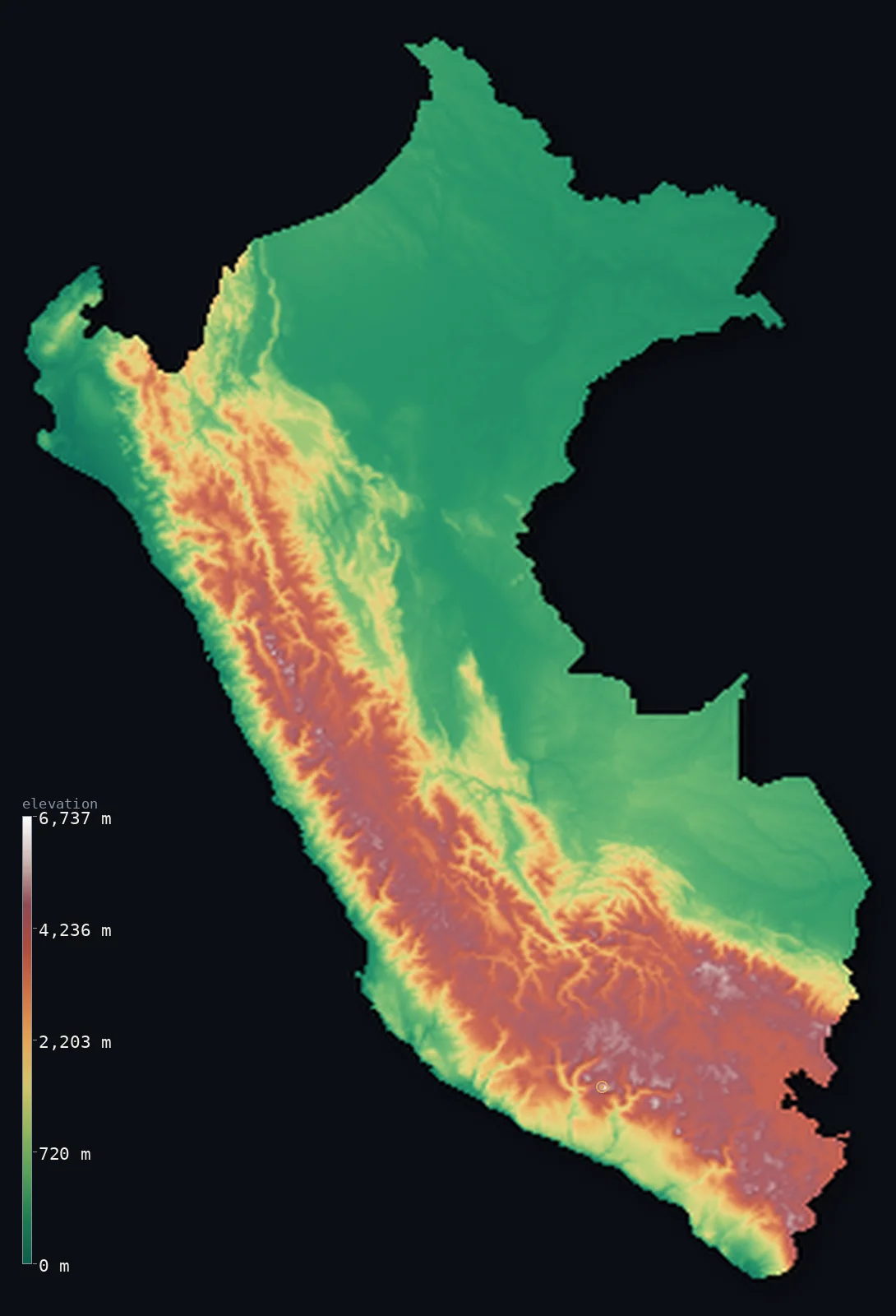
Peru’s highest point is Huascaran at 22,205 ft (6,768 m); its lowest is Pacific Ocean at 0 ft (0 m); the mean elevation is 4,810 ft (1,466 m).
Peru is three countries laid side by side. A narrow desert coast runs along the Pacific; behind it the Andes rise to over 6,000 m; and beyond the mountains the land falls away into Amazon rainforest that covers more than half the country. The split shows in the numbers: half of Peru lies below 1,509 ft (460 m), yet its mean elevation is 4,810 ft (1,466 m) — three times higher, because the Andean third stands so far above the rest.
- Highest point📚
- 22,205 ft6,768 m
- Peru's highest point is Huascarán at 22,205 ft (6,768 m), in the Cordillera Blanca — the highest peak in Peru and the crown of the most heavily glaciated tropical mountain range on Earth.
- Lowest point📚
- 0 ft0 m
- Peru's lowest point is the Pacific at sea level, along a coastal desert so dry that the strip between the ocean and the Andean foothills is almost entirely rainless.
- Mean elevation⚙
- 4,810 ft1,466 m
- Peru's mean elevation computed from the GLO-30 model is 4,810 ft (1,466 m) — but that average describes almost nowhere in Peru: it is the arithmetic midpoint between a vast low rainforest and a narrow band of very high mountains, not a typical height.
- Median elevation⚙
- 1,509 ft460 m
- Half of Peru lies below 1,509 ft (460 m) — barely a third of the mean, the widest such gap of any Andean country, and the clearest possible statement that most of Peru is not mountain at all but low Amazon lowland east of the range.
- Elevation range📚
- 22,205 ft6,768 m
- From the Pacific shore to Huascarán's summit, Peru spans about 22,200 ft — and it crosses that range twice over in cross-section, rising from desert coast to Andean crest and falling again into the Amazon basin.
- Above 1,000 m (3,281 ft)⚙
- 41%
- About 41% of Peru lies above 1,000 m (3,281 ft) — essentially the Andean belt through the middle of the country, where the great majority of Peruvians outside Lima live.
- Above 2,000 m (6,562 ft)⚙
- 31%
- Roughly 31% of Peru stands above 2,000 m (6,562 ft), with about 24% above 3,000 m — a high-altitude share that includes the altiplano, the mining towns, and cities like Huancayo living permanently above 10,000 ft.
- Official area📚
- 496,224 mi²1,285,216 km²
- Peru covers about 496,224 sq mi (1,285,216 sq km) — the third-largest country in South America, holding a desert coast, a full width of the Andes, and a share of the Amazon basin all at once.
- Forest cover📚
- 57.7%
- About 58% of Peru is forested — a striking figure for a country famous for mountains, and a reminder that the Amazon lowland east of the Andes makes up more of Peru than the range itself.
Highest and lowest points
Peru's highest point is Huascarán, 22,205 ft (6,768 m), in the Cordillera Blanca of central Peru — the highest summit in the country and in the most glaciated tropical mountain range in the world. Its glaciers have been retreating fast, and the mountain has a violent history: a 1970 earthquake shook loose a rock-and-ice avalanche from its slopes that buried the town of Yungay below. Unusually for a great Andean peak, it stands well inside Peru rather than on a border.
source ↗Peru's lowest point is the Pacific at sea level, but the coast is remarkable for what is missing: rain. A cold offshore current and the Andean rain shadow make this one of the driest coastlines on Earth — Lima, a city of over ten million, sits in near-desert and receives only a few millimetres of rain a year, watered instead by rivers running down from the mountains behind it.
source ↗Peru at a glance
Huascarán, 6,768 m, is the highest mountain in Peru and the high point of the Cordillera Blanca - the most heavily glaciated tropical mountain range on Earth.
source ↗Peru divides into three parallel bands - the desert Costa, the Andean Sierra, and the Amazonian Selva - and the Selva alone covers more than half the country.
source ↗Half of Peru lies below about 460 m even though its mean elevation is 1,466 m - the gap is the Amazon lowland set against the narrow Andean spine.
source ↗Lima, one of the largest cities in the Americas, sits in coastal desert and receives only a few millimetres of rain a year.
source ↗Lake Titicaca, on the Peru-Bolivia border at about 3,810 m, is the highest large navigable lake in the world.
source ↗Peru's Andes carry more tropical glaciers than any other country, though they have lost a large share of their ice in recent decades.
source ↗
Elevation profile of Peru
The largest share of land, 51%, falls in the 0–500 m band, with the land split almost evenly above and below 500 m (1,640 ft).
- below 500 m (1,640 ft)51%
- 500–1,000 m7%
- 1,000–2,000 m10%
- above 2,000 m (6,562 ft)31%
Highest peaks of Peru
| Peak | Elevation | Range | Note |
|---|---|---|---|
| Huascaran↗ | 22,205 ft6,768 m | Cordillera Blanca (Ancash) | Highest point of Peru and the highest mountain in the tropics, a glaciated peak in the Cordillera Blanca. |
| Yerupaja↗ | 21,768 ft6,635 m | Cordillera Huayhuash | The second-highest peak in Peru, in the compact Cordillera Huayhuash south of the Blanca. |
| Coropuna↗ | 21,079 ft6,425 m | Cordillera Ampato (Arequipa) | A massive ice-capped volcano in the southern Andes, the highest in Peru's volcanic zone. |
| Ausangate↗ | 20,945 ft6,384 m | Cordillera Vilcanota (Cusco) | A glaciated peak in the southern Andes near Cusco, beside the Rainbow Mountain. |
| El Misti↗ | 19,101 ft5,822 m | Volcanic cordillera (Arequipa) | The iconic symmetrical volcano rising above the city of Arequipa. |
The three bands of Peru
La Costa (the desert coast)
A narrow strip of desert runs the length of Peru's Pacific shore — almost rainless, crossed by short rivers that carry Andean meltwater to the sea. Despite being one of the driest coastlines on Earth, it holds Lima and much of the country's population, clustered in the river oases.
La Sierra (the Andes)
Behind the coast the Andes rise abruptly into several parallel cordilleras, carrying Huascarán and a crowd of peaks above 6,000 m, with high plateaus and basins between them. This is where highland Peru lives, in valleys and towns often above 3,000 m, up to the altiplano and Lake Titicaca on the Bolivian border.
La Selva (the Amazon)
East of the mountains the land drops into the Amazon basin, and keeps dropping — the forested lowland covers more than half of Peru's area while holding a small share of its people. Rivers rising in the Andes gather here into the headwaters of the Amazon itself.
How to read this map
Color shows elevation; the raised relief shows real terrain. On this map Peru reads as three stripes — a thin dry coastal edge, a broad white-and-brown Andean band through the middle, and a vast flat green expanse of Amazon lowland to the east.
The 3D relief is the actual GLO-30 elevation data, exaggerated vertically so the mountain band and the lowland both show; the ×N relief slider controls how much. Tap anywhere to read that point's exact elevation.
City elevations in Peru
Peru's cities show the country's three bands plainly. Lima sits on the desert coast just above sea level, while Arequipa stands at over 7,600 ft and Huancayo above 10,600 ft in the Andes — everyday life carried on at altitudes most countries never reach.
| City | Population | Elevation |
|---|---|---|
| Limacapitalthe capital, on the near-rainless desert coast just above sea level ↗ | 7,737,002 | 509 ft155 m |
| Arequipain a southern Andean valley at about 2,340 m, beneath the volcano El Misti ↗ | 1,008,290 | 7,677 ft2,340 m |
| Trujillo | 919,899 | 95 ft29 m |
| Chiclayo | 552,508 | 89 ft27 m |
| Piura | 484,475 | 125 ft38 m |
| Huancayohigh in the central Andes at about 3,250 m, in the Mantaro valley ↗ | 456,250 | 10,676 ft3,254 m |
| Cusco | 428,450 | 10,945 ft3,336 m |
| Iquitos | 377,609 | 308 ft94 m |
| Pucallpa | 326,040 | 518 ft158 m |
| Tacna | 286,240 | 1,824 ft556 m |
Elevation sampled at each city centre from the Copernicus GLO-30 model. Cities and population from GeoNames (CC-BY 4.0).
Peru in comparison
Peru's terrain rises 22,205 ft (6,768 m) from sea level to Huascaran — about 76% of the height of Mount Everest, the world's highest point at 29,032 ft (8,849 m).
- Bolivia's mean elevation is 4,042 ft — 768 ft lower; its high point, Nevado Sajama, reaches 21,463 ft (6,542 m), 741 ft below. Bolivia elevation map →
- Ecuador's mean elevation is 3,530 ft — 1,280 ft lower; its high point, Chimborazo, reaches 20,548 ft (6,263 m), 1,657 ft below. Ecuador elevation map →
- Chile's mean elevation is 4,341 ft — 469 ft lower; its high point, Ojos del Salado, reaches 22,615 ft (6,893 m), 410 ft above. Chile elevation map →
Frequently asked questions
What is the highest point in Peru?
- Huascarán, 22,205 ft (6,768 m), in the Cordillera Blanca - the highest peak in Peru and the crown of the world's most glaciated tropical range.
What is the lowest point in Peru?
- The Pacific coast at sea level - a desert shoreline that receives almost no rain.
What is the average elevation of Peru?
- Computed from the Copernicus GLO-30 model, the area-weighted mean is 4,810 ft (1,466 m) - but half the country lies below about 460 m, since the low Amazon covers more of Peru than the mountains do.
What are Peru's three regions?
- The Costa, a narrow desert coast; the Sierra, the high Andes through the middle; and the Selva, the Amazon rainforest that covers more than half the country.
How much of Peru is Amazon rainforest?
- More than half its area - the Selva east of the Andes is the largest of Peru's three regions, though far fewer people live there than on the coast or in the highlands.
Is this a topographic, relief, contour, or elevation map of Peru?
- They describe the same thing - terrain height. This page renders the country's actual elevation surface in interactive 3D and reports the statistics computed from it.
About this map
The terrain is rendered from the Copernicus GLO-30 digital elevation model (ESA), masked to the PER-ADM0 boundary from geoBoundaries (gbOpen). Elevation statistics are computed directly from the model; peak names and researched facts are sourced and cited. See the methodology for the full pipeline.
Our area-weighted mean, computed from the Copernicus GLO-30 model, is 4,810 ft (1,466 m); the figure commonly cited elsewhere is 5,102 ft (1,555 m) (CIA World Factbook). Peru rises from a narrow Pacific desert coast across the high Andes to the vast Amazon lowlands, so its terrain spans an enormous range and its mean elevation is moderately high; the page reports the area-weighted figure computed from the Copernicus GLO-30 model.
Surveyed national figures: official area · forest cover · high point.
Rendered from Copernicus GLO-30 (ESA, 2021 release), boundaries from geoBoundaries. Generated 2026-06-21.
Bordering countries · 5
Peru shares a land border with these countries — open any one to compare its terrain and highest point.