Brazil Elevation Map — Topographic & 3D Terrain
Explore the terrain of Brazil in interactive 3D, built from Copernicus GLO-30 satellite elevation data — a vast country of ancient worn highlands and the world's greatest lowland rainforest. Drag to rotate, scroll to zoom, and tap any point to read its elevation.
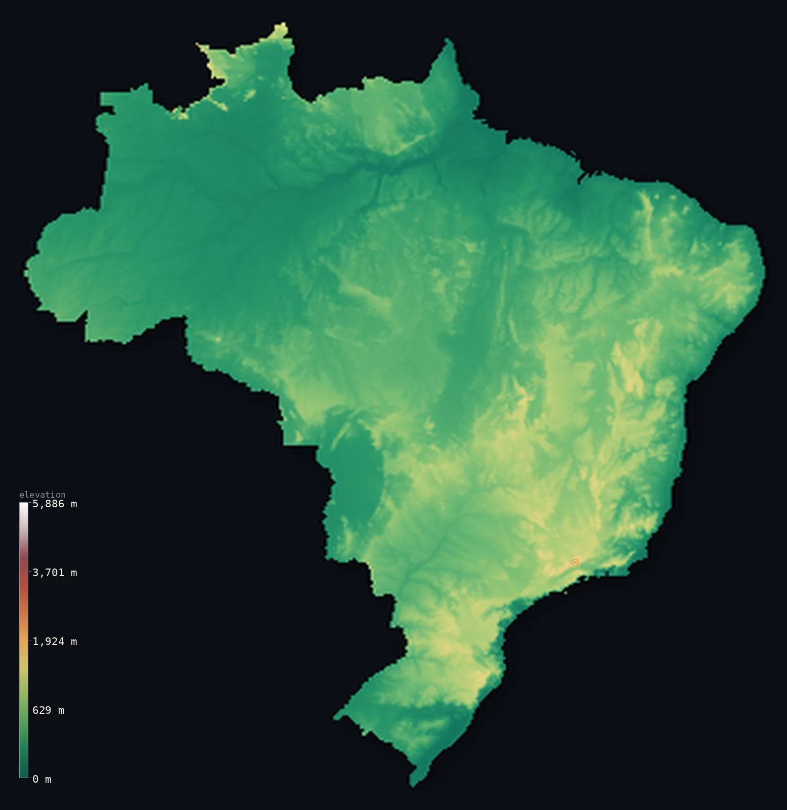
Brazil’s highest point is Pico da Neblina at 9,826 ft (2,995 m); its lowest is Atlantic Ocean at 0 ft (0 m); the mean elevation is 1,050 ft (320 m).
Brazil is enormous and, for its size, remarkably low. Nearly four-fifths of the country lies below 500 m (1,640 ft), split between the flat Amazon basin in the north and the rolling Brazilian Highlands to the south — an ancient, worn-down plateau whose 'mountains' barely reach 3,000 m. Its highest point, Pico da Neblina at 9,826 ft (2,995 m), hides in the far north on the Venezuelan border, far from the populated coast.
- Highest point📚
- 9,826 ft2,995 m
- Brazil's highest point is Pico da Neblina at 9,826 ft (2,995 m), a sheer sandstone tower in the remote Amazon rainforest on the Venezuelan border — so cloud-wrapped (its name means 'peak of the mist') and so isolated that it was not even confirmed as the country's summit until the 1960s.
- Lowest point📚
- 0 ft0 m
- Brazil's lowest point is the Atlantic coast at sea level — a long, low shoreline where the highlands drop to the ocean, and where most of the country's people and cities are gathered.
- Mean elevation⚙
- 1,050 ft320 m
- Brazil's mean elevation computed from the GLO-30 model is just 1,050 ft (320 m) — strikingly low for so vast a country, because Brazil has no great mountain range at all: only the flat Amazon lowland and the low, ancient plateau of the highlands.
- Median elevation⚙
- 827 ft252 m
- Half of Brazil lies below 827 ft (252 m), which captures the country's essential flatness — an old, eroded landmass worn down over hundreds of millions of years, with no young mountains to lift it.
- Elevation range📚
- 9,826 ft2,995 m
- From the Atlantic shore to Pico da Neblina, Brazil's entire vertical range is under 10,000 ft — modest for a country this large, and a sign that its terrain is all lowland and worn upland, never true high mountain.
- Above 1,000 m (3,281 ft)⚙
- 2%
- Only about 2% of Brazil rises above 1,000 m (3,281 ft) — scattered high points of the Brazilian Highlands and the remote northern peaks. The overwhelming majority of the country is low.
- Official area📚
- 3,287,955 mi²8,515,767 km²
- Brazil covers about 3.3 million sq mi (8.5 million sq km), the fifth-largest country on Earth — and holds within it the greater part of the Amazon, the world's largest tropical rainforest, spread across a lowland basin so flat that rivers wander for thousands of miles at a gentle fall.
- Forest cover📚
- 59.4%
- About 59% of Brazil is forested — a huge share driven by the Amazon, the largest rainforest on the planet, though its extent has been shrinking under deforestation along the agricultural frontier.
Highest and lowest points
Brazil's highest point is Pico da Neblina, 9,826 ft (2,995 m), a sandstone peak deep in the Amazon rainforest on the border with Venezuela. Its name means 'peak of the mist' — it is almost perpetually shrouded in cloud, and so remote that its status as Brazil's highest was only established in the mid-20th century. On this elevation model the peak's sharp summit reads lower than its surveyed height, and the highest point visible on the map is in fact a different mountain, Pico da Bandeira in the southeast; the figure above is Neblina's surveyed elevation.
source ↗Brazil's lowest point is simply the Atlantic Ocean at sea level, along a coastline that runs more than 7,000 km. It is here, where the Brazilian Highlands drop toward the sea, that most of the country lives — the great coastal cities of Rio de Janeiro, São Paulo's port at Santos, Salvador, and Recife strung along the shore.
source ↗Pico da Neblina's surveyed summit sits just outside the generalized Brazil boundary, so the highest fully in-territory land pixel in the model is 9,423 ft (2,872 m). The headline figure above is the surveyed elevation of the recognised national high point.
Brazil at a glance
Brazil's highest point, Pico da Neblina (2,995 m), sits in remote Amazon rainforest on the Venezuelan border and was only confirmed as the country's summit in the 1960s.
source ↗Nearly four-fifths of Brazil lies below 500 m — it has no major mountain range, only the flat Amazon basin and the low, ancient Brazilian Highlands.
source ↗Brazil holds the largest share of the Amazon, the world's biggest tropical rainforest, in a lowland basin so flat that its rivers fall only a few centimetres per kilometre.
source ↗The Brazilian Highlands are among the oldest land surfaces on Earth, worn down over hundreds of millions of years to gentle plateaus and rounded ranges.
source ↗The capital, Brasília, was built from scratch in the 1950s on the high central plateau at about 1,100 m, far inland from the crowded coast.
source ↗Most Brazilians live within a few hundred kilometres of the Atlantic, where the highlands meet the sea along a coastline over 7,000 km long.
source ↗
Elevation profile of Brazil
The largest share of land, 42%, falls in the 0–200 m band, and 79% of the territory lies below 500 m (1,640 ft).
- below 500 m (1,640 ft)79%
- 500–1,000 m20%
- 1,000–2,000 m2%
- above 2,000 m (6,562 ft)<1%
Highest peaks of Brazil
| Peak | Elevation | Range | Note |
|---|---|---|---|
| Pico da Neblina↗ | 9,826 ft2,995 m | Serra do Imeri (Guiana Highlands) | Highest point of Brazil, in the far north at the Venezuelan border. |
| Pico 31 de Marco↗ | 9,757 ft2,974 m | Serra do Imeri (Guiana Highlands) | Brazil's second-highest peak, on the international border beside Neblina. |
| Pico da Bandeira↗ | 9,488 ft2,892 m | Serra do Caparao (Mantiqueira) | The highest peak of the populated southeast, long thought to be Brazil's highest before Neblina. |
| Pedra da Mina↗ | 9,180 ft2,798 m | Serra da Mantiqueira | A high summit of the Mantiqueira range between Minas Gerais and Sao Paulo. |
| Pico das Agulhas Negras↗ | 9,157 ft2,791 m | Serra da Mantiqueira (Itatiaia) | A landmark peak of Itatiaia National Park in the southeastern highlands. |
The two faces of Brazil
The Amazon basin (north)
The northern half of Brazil is the vast, flat lowland of the Amazon — a basin so level that the great river and its tributaries meander for thousands of kilometres at a barely perceptible fall, under the largest rainforest on Earth.
The Brazilian Highlands (centre and south)
South of the Amazon the land rises into the Brazilian Highlands, an ancient, worn plateau of rolling uplands rarely above 1,200 m. Deeply eroded over eons, it holds most of the country's people, farmland, and inland cities, including the planned capital of Brasília.
The northern peaks and the coast
Brazil's few true high points stand in the remote north — Pico da Neblina and its neighbours on the Guiana Shield — while in the southeast the highlands break off sharply at the Serra do Mar, dropping to the narrow Atlantic coastal strip where the great cities lie.
How to read this map
Color shows elevation; the raised relief shows real terrain. On this map Brazil reads mostly green and low — the flat Amazon in the north, the gently raised browns of the highlands to the south, with only faint high points.
The 3D relief is the actual GLO-30 elevation data, exaggerated vertically so the low plateau and its edges show any shape at all; the ×N relief slider controls how much. Tap anywhere to read that point's exact elevation.
City elevations in Brazil
Brazil's cities split between the low Atlantic coast and the higher inland plateau. Rio de Janeiro and the great port cities sit at sea level along the shore, while São Paulo and the planned capital, Brasília, stand high on the Brazilian Highlands.
| City | Population | Elevation |
|---|---|---|
| São Pauloon the highlands just inland from the coast, at about 760 m - Brazil's largest city ↗ | 12,400,232 | 2,493 ft760 m |
| Rio de Janeiroon the Atlantic coast at sea level, hemmed in by steep coastal peaks ↗ | 6,747,815 | 39 ft12 m |
| Belo Horizonte | 2,721,564 | 2,831 ft863 m |
| Salvador | 2,711,840 | 184 ft56 m |
| Fortaleza | 2,400,000 | 46 ft14 m |
| Manaus | 2,219,580 | 98 ft30 m |
| Brasíliacapitalthe capital, built in the 1950s on the high central plateau at about 1,100 m ↗ | 2,207,718 | 3,727 ft1,136 m |
| Curitiba | 1,948,626 | 3,002 ft915 m |
| Recife | 1,653,461 | 16 ft5 m |
| Goiânia | 1,536,097 | 2,487 ft758 m |
Elevation sampled at each city centre from the Copernicus GLO-30 model. Cities and population from GeoNames (CC-BY 4.0).
Brazil in comparison
Brazil's terrain rises 9,826 ft (2,995 m) from sea level to Pico da Neblina — about 34% of the height of Mount Everest, the world's highest point at 29,032 ft (8,849 m).
- Argentina's mean elevation is 2,323 ft — 1,273 ft higher; its high point, Cerro Aconcagua, reaches 22,838 ft (6,961 m), 13,012 ft above. Argentina elevation map →
- Venezuela's mean elevation is 1,142 ft — 92 ft higher; its high point, Pico Bolívar, reaches 16,332 ft (4,978 m), 6,506 ft above. Venezuela elevation map →
- Colombia's mean elevation is 1,834 ft — 784 ft higher; its high point, Pico Cristóbal Colón, reaches 18,947 ft (5,775 m), 9,121 ft above. Colombia elevation map →
Frequently asked questions
What is the highest point in Brazil?
- Pico da Neblina, 9,826 ft (2,995 m), a sandstone peak in remote Amazon rainforest on the Venezuelan border - the highest point in the country.
What is the lowest point in Brazil?
- The Atlantic coast at sea level, along a shoreline more than 7,000 km long where most Brazilians live.
Why is Brazil so flat?
- Brazil has no major mountain range - it is made of the flat Amazon lowland and the ancient, deeply eroded Brazilian Highlands, so nearly four-fifths of it lies below 500 m.
Where is the Amazon rainforest in Brazil?
- Across the vast, flat northern basin of the country - Brazil holds the largest part of the Amazon, the world's biggest tropical rainforest.
What is the average elevation of Brazil?
- Computed from the GLO-30 model, Brazil's area-weighted mean is 1,050 ft (320 m) - strikingly low for so vast a country, which has no great mountain range, only lowland and worn plateau.
Is this a topographic, relief, contour, or elevation map of Brazil?
- They describe the same thing - terrain height. This page renders the country's actual elevation surface in interactive 3D and reports the statistics computed from it.
About this map
The terrain is rendered from the Copernicus GLO-30 digital elevation model (ESA), masked to the BRA-ADM0 boundary from geoBoundaries (gbOpen). Elevation statistics are computed directly from the model; peak names and researched facts are sourced and cited. See the methodology for the full pipeline.
This map renders 8,510,224 km² across 163 landmasses of Brazil. 4 smaller outlying parts — 28 km² in total — lie beyond the area shown here. Area statistics above count the full territory.
Because Brazil covers 8,510,224 km², its 3D terrain surface is rendered at roughly 2.3 km per pixel rather than the model’s native 30 m — the full-resolution grid exceeds the render budget for an area this large. The high point and every elevation figure on this page are still measured at native 30 m resolution; only the rendered surface detail is coarsened.
Our area-weighted mean, computed from the Copernicus GLO-30 model, is 1,050 ft (320 m); the figure commonly cited elsewhere is 1,050 ft (320 m) (CIA World Factbook). Brazil is mostly low - the vast Amazon basin and the coastal plains - with higher ground confined to the southeastern highlands and the northern shield, giving a low mean; the page reports the area-weighted figure computed from the Copernicus GLO-30 model, shown at reduced surface resolution for a country this large.
Surveyed national figures: official area · forest cover · high point.
Rendered from Copernicus GLO-30 (ESA, 2021 release), boundaries from geoBoundaries. Generated 2026-07-12.
Bordering countries · 9
Brazil shares a land border with these countries — open any one to compare its terrain and highest point.