Suriname Elevation Map — Topographic & 3D Terrain
Explore the terrain of Suriname in interactive 3D, built from Copernicus GLO-30 satellite elevation data — a low, densely forested country of the Guiana Shield, from a below-sea coast to interior highlands. Drag to rotate, scroll to zoom, and tap any point to read its elevation.
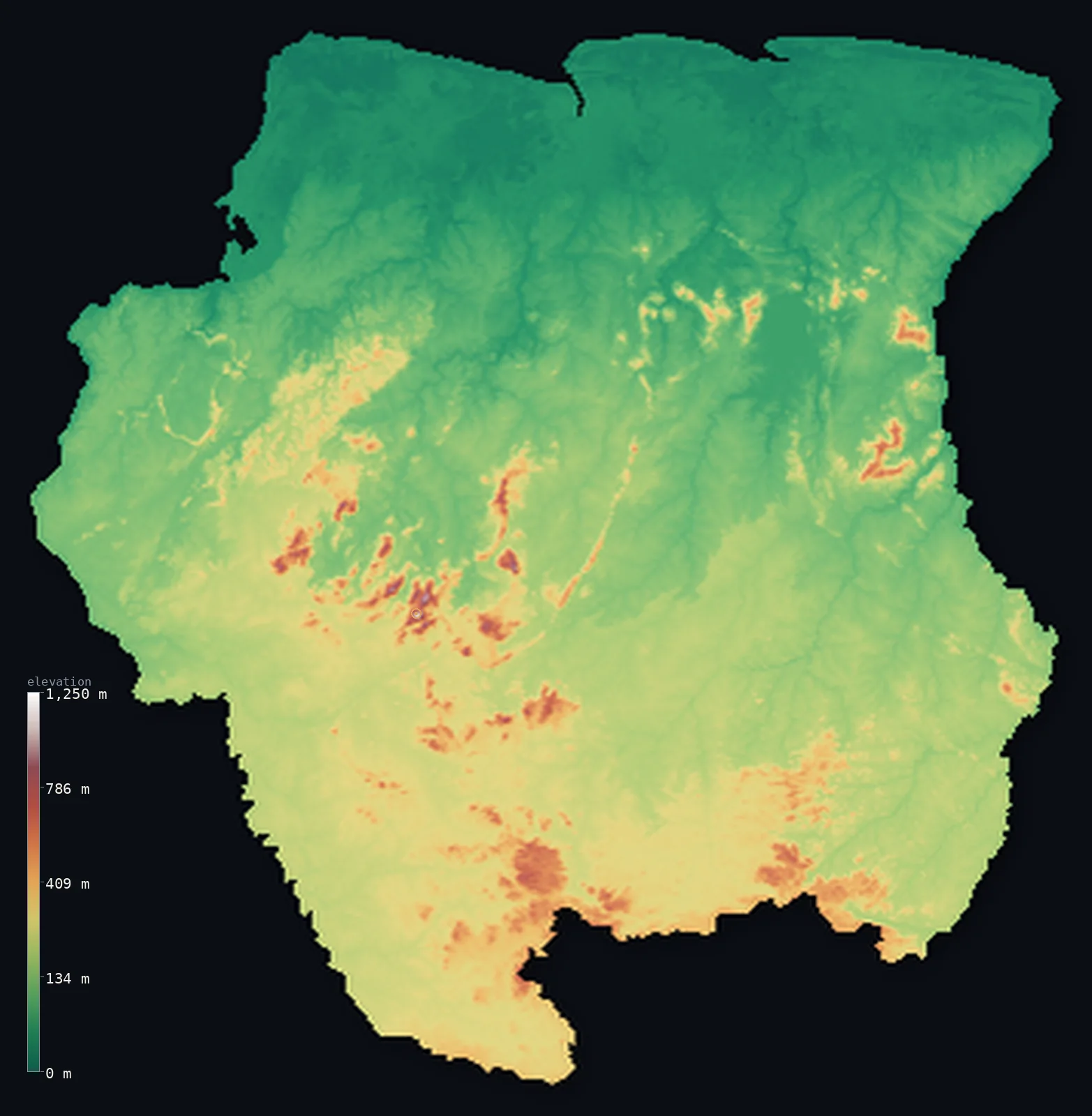
Suriname’s highest point is Julianatop at 4,199 ft (1,280 m); its lowest is Coastal plain at −7 ft (−2 m); the mean elevation is 515 ft (157 m).
Suriname is a low, green country — among the most forested on Earth, almost entirely covered in the rainforest of the Guiana Shield. Its people live almost all on a narrow northern coastal plain along the Atlantic, low and flat, parts of which lie below sea level and are protected, in the Dutch manner, by dikes and drainage. Behind the coast, unbroken rainforest stretches south across the vast interior — a low, rolling, thinly peopled land of the Guiana Shield, rising gently to modest interior highlands and, at its highest, Julianatop, at 4,199 ft (1,280 m). Suriname is low and even: there are no great mountains, only endless forest rising slowly inland.
- Highest point📚
- 4,199 ft1,280 m
- Suriname's highest point is Julianatop at 4,199 ft (1,280 m), a forested summit in the interior highlands of the Guiana Shield, deep in the country's rainforest heart — the highest of a low, rolling upland of the shield, not a great peak but the crown of an even, forested land. Much of Suriname lies far lower, in the vast rainforest and the coastal plain.
- Lowest point📚
- −7 ft−2 m
- Suriname's lowest point is on the Atlantic coast, where parts of the low northern coastal plain lie below sea level — about 7 ft (2 m) below at the lowest — protected from the sea, in the Dutch tradition, by dikes and drainage. It is a low, wet coast of the kind the Netherlands made famous.
- Mean elevation⚙
- 515 ft157 m
- Computed from the GLO-30 model, Suriname's mean elevation is 515 ft (157 m) — a low figure, and a fitting one for a country that is low and even throughout: unbroken rainforest of the Guiana Shield covers almost all of it, rising only gently from the below-sea coast to modest interior highlands, with no great heights to raise the average.
- Median elevation⚙
- 453 ft138 m
- Half of Suriname lies below about 453 ft (138 m) — close to the mean, because the country is so uniformly low: the vast forested lowlands of the shield, rising only gradually inland, make up nearly all of it, with only the modest interior highlands standing somewhat higher.
- Elevation range📚
- 4,206 ft1,282 m
- From the below-sea coast to the summit of Julianatop at 1,280 m, Suriname's terrain spans about 4,210 ft — a modest range, since Suriname is a low, even, forested land, its highlands gentle and its coast below the level of the sea.
- Above 1,000 m (3,281 ft)⚙
- <1%
- Barely any of Suriname rises above 1,000 m (<1%) — only the highest of the modest interior highlands of the Guiana Shield, deep in the country's south and centre; even 500 m is cleared by only 2% of the country. The vast forested lowlands and the coastal plain lie far below.
- Official area📚
- 63,251 mi²163,820 km²
- Suriname covers about 63,251 sq mi (163,820 sq km) — a small, low country on the northeast coast of South America, among the most heavily forested on Earth, of a below-sea Atlantic coastal plain and vast Guiana Shield rainforest rising gently to modest interior highlands.
- Forest cover📚
- 97.4%
- About 97% of Suriname is forested — among the highest proportions of any country on Earth, an almost unbroken cover of tropical rainforest across the Guiana Shield, from the coastal lowlands to the interior highlands, one of the most pristine great forests anywhere.
Highest and lowest points
Suriname's highest point is Julianatop, 4,199 ft (1,280 m), a forested summit deep in the interior highlands of the Guiana Shield, near the centre of the country. It is the highest of the Wilhelmina Mountains and the other modest ranges that rise from the vast rainforest of Suriname's interior — low, rounded, forest-covered highlands rather than any great peak. In a country that is low and even throughout, almost entirely covered in unbroken rainforest, Julianatop is simply the highest of the gentle interior rises. Much of Suriname lies far lower, in the endless forested lowlands and the below-sea coastal plain, and there are no true mountains here — only the quiet, green crown of the shield.
source ↗Suriname's lowest point is on the Atlantic coast, where parts of the low northern coastal plain lie below sea level — about 7 ft (2 m) below at the lowest point. As in the neighbouring Guyana, and in the Netherlands that once ruled here, this low, wet coast is protected from the sea by dikes and drained by canals, and it is where nearly all Surinamese live, including in the capital, Paramaribo, on the Suriname River. Behind this narrow coastal strip, the land is almost entirely rainforest: the vast, low, rolling interior of the Guiana Shield, thinly peopled and rising only gradually southward to modest highlands. Suriname is a low and even country — among the most forested on Earth — with no great relief, only endless forest between a below-sea coast and gentle interior hills.
source ↗Suriname at a glance
Suriname is among the most forested countries on Earth - about 97% of it is covered in the unbroken rainforest of the Guiana Shield.
source ↗Parts of Suriname's low northern coastal plain lie below sea level - protected, in the Dutch tradition, by dikes and drainage, where nearly all the population lives.
source ↗Suriname is low and even - unbroken rainforest rising only gently from a below-sea coast to modest interior highlands, with no great mountains; its highest point, Julianatop, is only 1,280 m.
source ↗The vast interior of Suriname is one of the most pristine stretches of rainforest on Earth - thinly peopled, largely roadless, and protected in part by the huge Central Suriname Nature Reserve.
source ↗Suriname was a Dutch colony until 1975 - and its low coast, dikes, and drainage recall the Netherlands, as does the capital, Paramaribo, with its Dutch colonial architecture.
source ↗The great rivers of Suriname - the Suriname, the Marowijne, the Corantijn - flow north from the interior highlands through the forest to the Atlantic.
source ↗
Elevation profile of Suriname
The largest share of land, 37%, falls in the 0–100 m band, and 98% of the territory lies below 500 m (1,640 ft).
- below 500 m (1,640 ft)98%
- 500–1,000 m2%
- 1,000–2,000 m<1%
Highest peaks of Suriname
| Peak | Elevation | Range | Note |
|---|---|---|---|
| Julianatop↗ | 4,199 ft1,280 m | Wilhelmina Mountains | Highest point of Suriname, a remote rainforest summit in the interior Wilhelmina Mountains. |
| Tafelberg↗ | 3,366 ft1,026 m | Wilhelmina Mountains area | A flat-topped sandstone tepui in the Central Suriname Nature Reserve, one of the country's best-known peaks. |
Suriname: the coastal plain, the forested lowlands, and the interior highlands
The below-sea coastal plain
Suriname's northern edge is a low, wet strip along the Atlantic — parts of it beneath sea level, held back by dikes and canals in the Dutch manner — where nearly all Surinamese live, above all in Paramaribo on the Suriname River. The country's populous, sea-defended fringe.
The rainforest interior
Behind the coast, unbroken rainforest cloaks almost the entire country — the low, rolling Guiana Shield interior, thinly peopled and threaded by the Suriname, Marowijne, and Corantijn rivers running north to the sea. Pristine and green, it is the overwhelming bulk of Suriname.
The interior highlands
Deep in the south and centre, the land rises to modest forested highlands — the Wilhelmina Mountains and other low ranges of the shield, holding Julianatop (the high point). Gentle, rounded, and forest-covered, they are the country's highest but never mountainous ground.
How to read this map
Color shows elevation; the raised relief shows real terrain. On this map Suriname reads as a low, even, green country — a broad expanse of low tone covering nearly all of it, the vast Guiana Shield rainforest, rising only gently to slightly higher ground in the interior highlands (highest at Julianatop) and dipping to the below-sea coast in the north.
With so little relief, the 3D exaggeration is what makes the gentle rise inland visible; the ×N relief slider controls how much. Tap anywhere to read that point's exact elevation.
City elevations in Suriname
Suriname's towns lie almost entirely on the northern coast — Paramaribo, the capital, on the Suriname River near the Atlantic, holds most of the country's people, with a few smaller coastal and river towns. The vast forested interior is nearly empty.
| City | Population | Elevation |
|---|---|---|
| Paramaribocapitalthe capital, on the Suriname River near the Atlantic coast ↗ | 223,757 | 13 ft4 m |
| Brokopondoin the interior, at the Brokopondo Reservoir ↗ | 14,662 | 69 ft21 m |
| Nieuw Nickerieon the west coast, near the Guyanese border ↗ | 12,818 | 16 ft5 m |
| Moengoa bauxite town in the northeast, on the Cottica River ↗ | 10,834 | 33 ft10 m |
| Totnesson the west-central coast (Coronie) ↗ | 2,150 | 23 ft7 m |
| Powakkain the interior, south of Paramaribo ↗ | 1,920 | 66 ft20 m |
Elevation sampled at each city centre from the Copernicus GLO-30 model. Cities and population from GeoNames (CC-BY 4.0).
Suriname in comparison
Suriname's terrain rises 4,206 ft (1,282 m) from Coastal plain, 7 ft (2 m) below sea level to Julianatop — about 14% of the height of Mount Everest, the world's highest point at 29,032 ft (8,849 m).
- Guyana's mean elevation is 712 ft — 197 ft higher; its high point, Mount Roraima (Guyana point), reaches 9,094 ft (2,772 m), 4,895 ft above. Guyana elevation map →
- Venezuela's mean elevation is 1,142 ft — 627 ft higher; its high point, Pico Bolívar, reaches 16,332 ft (4,978 m), 12,133 ft above. Venezuela elevation map →
- Brazil's mean elevation is 1,050 ft — 535 ft higher; its high point, Pico da Neblina, reaches 9,826 ft (2,995 m), 5,627 ft above. Brazil elevation map →
Frequently asked questions
What is the highest point in Suriname?
- Julianatop, 4,199 ft (1,280 m), a forested summit in the interior highlands of the Guiana Shield - the highest of a low, rolling, forested upland, not a great peak.
What is the lowest point in Suriname?
- The Atlantic coast, where parts of the low northern plain lie below sea level - about 7 ft (2 m) below - protected, in the Dutch manner, by dikes and drainage.
What is the average elevation of Suriname?
- Computed from the Copernicus GLO-30 model, the area-weighted mean is 515 ft (157 m) - low, and close to the median, because Suriname is low and even throughout, almost entirely covered in rainforest with no great heights.
How forested is Suriname?
- It is among the most forested countries on Earth - about 97% of it is covered in the unbroken rainforest of the Guiana Shield, one of the most pristine great forests anywhere.
Does Suriname lie below sea level?
- Parts of its low northern coastal plain do - about 2 m below at the lowest - protected, in the Dutch tradition, by dikes and drainage, where nearly all the population lives.
Is this a topographic, relief, contour, or elevation map of Suriname?
- They describe the same thing - terrain height. This page renders the country's actual elevation surface in interactive 3D and reports the statistics computed from it.
About this map
The terrain is rendered from the Copernicus GLO-30 digital elevation model (ESA), masked to the SUR-ADM0 boundary from geoBoundaries (gbOpen). Elevation statistics are computed directly from the model; peak names and researched facts are sourced and cited. See the methodology for the full pipeline.
Our area-weighted mean, computed from the Copernicus GLO-30 model, is 515 ft (157 m); the figure commonly cited elsewhere is 807 ft (246 m) (CIA World Factbook). Suriname is not a country of high ground and low ground, but of low ground almost everywhere. Unbroken rainforest of the Guiana Shield covers nearly the whole country, rising only gently from a below-sea coast to modest interior highlands — no great mountains, no high plateau. So the mean and the median are close, and both low: half of Suriname lies below about 453 ft (138 m), well under the higher average sometimes cited elsewhere, and the typical point is low forest. It is a land defined by its evenness and its trees.
Surveyed national figures: official area · forest cover · high point.
Rendered from Copernicus GLO-30 (ESA, 2021 release), boundaries from geoBoundaries. Generated 2026-07-07.
Bordering countries · 2
Suriname shares a land border with these countries — open any one to compare its terrain and highest point.