Uruguay Elevation Map — Topographic & 3D Terrain
Explore the terrain of Uruguay in interactive 3D, built from Copernicus GLO-30 satellite elevation data — a low country of gently rolling grassland between the River Plate and the Atlantic. Drag to rotate, scroll to zoom, and tap any point to read its elevation.
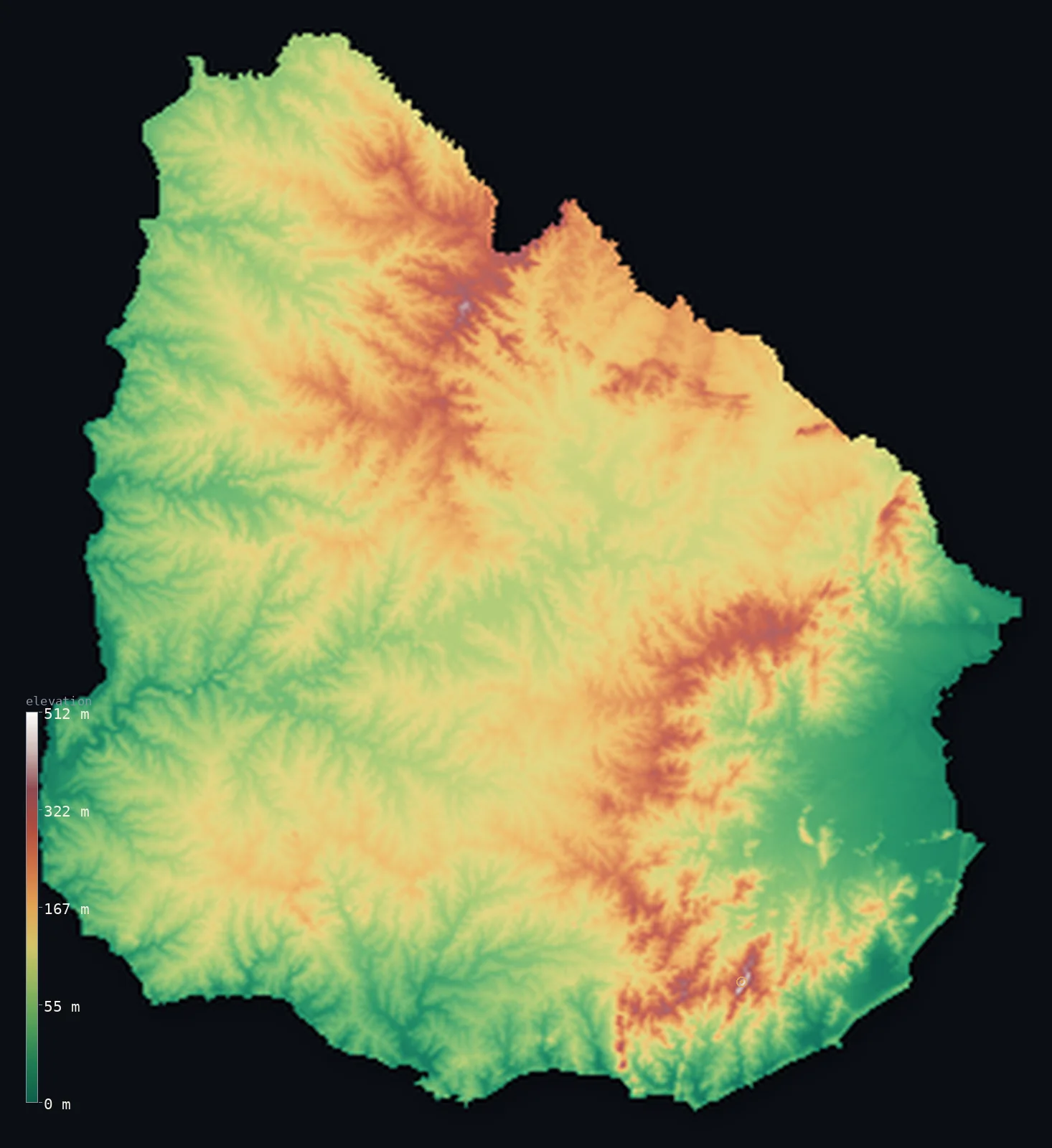
Uruguay’s highest point is Cerro Catedral at 1,686 ft (514 m); its lowest is Atlantic Ocean at 0 ft (0 m); the mean elevation is 361 ft (110 m).
Uruguay is a low, gently rolling country — one of the flattest in South America, though not quite flat. It has no mountains and no true lowland plains either, but a landscape of low, rolling ridges called cuchillas, running across the country between broad river valleys, nowhere rising very high: the highest point, Cerro Catedral, reaches just 1,686 ft (514 m). The land slopes gently toward the great waters that border it — the Río de la Plata and the Uruguay River in the south and west, the Atlantic in the east — and is covered largely in the rich grassland of the Pampas. It is an even country: half of it lies below about 340 ft, and the rest not far above.
- Highest point📚
- 1,686 ft514 m
- Uruguay's highest point is Cerro Catedral at 1,686 ft (514 m), a modest summit in the Sierra Carapé of the southeast — the highest of the low, rolling ridges (the cuchillas) that cross the country. Uruguay has no mountains; even its highest point is a low hill, and the land as a whole is gently rolling grassland, rarely far from this modest height or far below it.
- Lowest point📚
- 0 ft0 m
- Uruguay's lowest point is the Atlantic Ocean at sea level, along the country's eastern and southern shores — the coast of the Atlantic and the great estuary of the Río de la Plata. The land slopes gently down to these waters from the low interior ridges, never from any real height.
- Mean elevation⚙
- 361 ft110 m
- Computed from the GLO-30 model, Uruguay's mean elevation is 361 ft (110 m) — a low figure, and one that describes the whole country well: Uruguay is remarkably even, a land of gently rolling grassland and low ridges with no mountains and no deep lowlands, so the typical point sits close to the average, and half the country lies below about 341 ft (104 m).
- Median elevation⚙
- 341 ft104 m
- Half of Uruguay lies below about 341 ft (104 m) — and, tellingly, this figure sits close to the mean, because Uruguay is so even a country: gently rolling grassland and low ridges, without the high mountains or deep lowlands that pull a country's mean and median apart. The land is nearly all of a modest, rolling height.
- Elevation range📚
- 1,686 ft514 m
- From the Atlantic coast to the summit of Cerro Catedral at 514 m, Uruguay's terrain spans only about 1,686 ft — one of the smallest ranges of any country, because Uruguay is low and even throughout: rolling grassland and low ridges, with no mountains and no great depths.
- Official area📚
- 68,037 mi²176,215 km²
- Uruguay covers about 68,000 sq mi (176,215 sq km) — a low, gently rolling South American country between the Río de la Plata and the Atlantic, of grassland and low ridges (the cuchillas), one of the flattest and most even countries on the continent, with no mountains and no great lowlands.
- Forest cover📚
- 11%
- About 11% of Uruguay is forested — a lightly wooded country, mostly open grassland (the Pampas), with native forest along the rivers and watercourses and planted forestry blocks, but no great woodlands.
Highest and lowest points
Uruguay's highest point is Cerro Catedral, 1,686 ft (514 m), a low summit in the Sierra Carapé in the southeast of the country. It is the highest of the cuchillas — the low, rolling ridges of grassland and rock that cross Uruguay — but it is no mountain: a modest hill, the tallest point in one of the flattest countries on the continent. Uruguay has no mountain ranges at all; its landscape is a gentle roll of grassy hills and ridges, nowhere rising far above the surrounding land, and Cerro Catedral is simply the highest of these low rises. From it, the country slopes away in every direction as rolling grassland toward the rivers and the sea.
source ↗Uruguay's lowest point is the Atlantic Ocean at sea level, along its eastern and southern coasts — the open Atlantic in the east and the vast estuary of the Río de la Plata in the south, where the Uruguay and Paraná rivers meet the sea and where the capital, Montevideo, sits. Uruguay slopes gently down to these great waters, but never from any height: the country is low and rolling throughout, a landscape of grassy hills and ridges — the cuchillas — running between broad, shallow river valleys. There are no mountains, and no true lowland plains either; Uruguay is remarkably even, one of the flattest countries in South America, its whole surface a gentle roll of Pampas grassland between modest heights and the bordering waters.
source ↗Uruguay at a glance
Uruguay is one of the flattest countries in South America - a land of gently rolling grassland and low ridges (the cuchillas), with no mountains; its highest point, Cerro Catedral, is just 514 m.
source ↗Uruguay is remarkably even - with no high mountains or deep lowlands, its mean and median elevations sit close together, both low.
source ↗Most of Uruguay is covered in the rich grassland of the Pampas - open, rolling pasture that makes the country one of the great cattle-raising lands of South America.
source ↗Uruguay is bordered by great waters - the Uruguay River in the west, the vast Río de la Plata estuary in the south, and the Atlantic in the east - toward which its gentle land slopes.
source ↗The low ridges that cross Uruguay are called cuchillas - 'knives' - long, low spines of higher ground between the country's broad, shallow river valleys.
source ↗Uruguay has no point higher than about 514 m and little truly low ground either - one of the most even countries in the world by elevation.
source ↗
Elevation profile of Uruguay
The largest share of land, 28%, falls in the 100–150 m band, and 100% of the territory lies below 500 m (1,640 ft).
- below 500 m (1,640 ft)100%
Highest peaks of Uruguay
Uruguay: the rolling cuchillas, the river lowlands, and the Atlantic coast
The rolling interior — the cuchillas
Most of Uruguay is gently rolling country — low ridges of grassland and rock (the cuchillas) running between broad, shallow river valleys, rising here and there to modest heights like Cerro Catedral (the high point). The even, grassy heart of the country.
The river lowlands — the west and south
Along the Uruguay River in the west and the Río de la Plata in the south lie broad, low river valleys and plains, sloping gently to the great waters and holding the capital, Montevideo. The low, watered margins of the country.
The Atlantic coast — the east
In the east, the land slopes to the Atlantic — a coast of beaches, dunes, lagoons, and low grassland. The country's gentle ocean edge.
How to read this map
Color shows elevation; the raised relief shows real terrain. On this map Uruguay reads as a low, even, gently rolling country — a soft, uniform low-to-middle tone across nearly all of it, the rolling grassland and low ridges (the cuchillas), rising only slightly to modest high points like Cerro Catedral in the southeast and sloping gently to the rivers and the Atlantic.
With so little relief, the 3D exaggeration is what makes the gentle roll visible at all; the ×N relief slider controls how much. Tap anywhere to read that point's exact elevation.
City elevations in Uruguay
Uruguay's cities cluster on the southern coast — Montevideo, the capital, on the Río de la Plata, holds nearly half the country's people, with others like Salto and Paysandú on the Uruguay River and coastal towns to the east. Most of the population lives low, near the water.
| City | Population | Elevation |
|---|---|---|
| Montevideocapitalthe capital, on the Río de la Plata ↗ | 1,270,737 | 112 ft34 m |
| Saltoon the Uruguay River in the northwest ↗ | 114,084 | 161 ft49 m |
| Maldonadonear the Atlantic coast in the southeast ↗ | 102,000 | 95 ft29 m |
| Riveraon the northern border with Brazil ↗ | 84,775 | 636 ft194 m |
| Paysandúon the Uruguay River ↗ | 81,550 | 135 ft41 m |
| Tacuarembóin the north-central interior ↗ | 60,586 | 433 ft132 m |
| Meloin the eastern interior ↗ | 56,013 | 348 ft106 m |
| Artigasin the far northwest, on the border with Brazil ↗ | 43,897 | 420 ft128 m |
| Mercedeson the Río Negro in the west ↗ | 43,543 | 95 ft29 m |
| Duraznoin the central interior ↗ | 40,279 | 308 ft94 m |
Elevation sampled at each city centre from the Copernicus GLO-30 model. Cities and population from GeoNames (CC-BY 4.0).
Uruguay in comparison
Uruguay's terrain rises 1,686 ft (514 m) from sea level to Cerro Catedral — about 6% of the height of Mount Everest, the world's highest point at 29,032 ft (8,849 m).
- Argentina's mean elevation is 2,323 ft — 1,962 ft higher; its high point, Cerro Aconcagua, reaches 22,838 ft (6,961 m), 21,152 ft above. Argentina elevation map →
- Brazil's mean elevation is 1,050 ft — 689 ft higher; its high point, Pico da Neblina, reaches 9,826 ft (2,995 m), 8,140 ft above. Brazil elevation map →
- Paraguay's mean elevation is 535 ft — 174 ft higher; its high point, Cerro Tres Kandu, reaches 2,762 ft (842 m), 1,076 ft above. Paraguay elevation map →
Frequently asked questions
What is the highest point in Uruguay?
- Cerro Catedral, 1,686 ft (514 m), a low hill in the southeastern Sierra Carapé - the highest of the cuchillas (the rolling ridges); Uruguay has no mountains.
What is the lowest point in Uruguay?
- The Atlantic Ocean at sea level, along the eastern and southern coasts - the Atlantic and the great Río de la Plata estuary.
What is the average elevation of Uruguay?
- Computed from the Copernicus GLO-30 model, the area-weighted mean is 361 ft (110 m) - low, and close to the median, because Uruguay is remarkably even: rolling grassland and low ridges with no mountains or deep lowlands.
Is Uruguay flat?
- Nearly - it is one of the flattest countries in South America, a land of gently rolling grassland and low ridges (the cuchillas) with no mountains. But it is not a flat plain: it rolls gently, rising to a highest point of 514 m.
Why are Uruguay's mean and median elevations so close?
- Because the country is so even - with no high mountains to pull the mean up or deep lowlands to pull it down, most of Uruguay sits at a similar modest height, so the average and the midpoint nearly coincide.
Is this a topographic, relief, contour, or elevation map of Uruguay?
- They describe the same thing - terrain height. This page renders the country's actual elevation surface in interactive 3D and reports the statistics computed from it.
About this map
The terrain is rendered from the Copernicus GLO-30 digital elevation model (ESA), masked to the URY-ADM0 boundary from geoBoundaries (gbOpen). Elevation statistics are computed directly from the model; peak names and researched facts are sourced and cited. See the methodology for the full pipeline.
Our area-weighted mean, computed from the Copernicus GLO-30 model, is 361 ft (110 m); the figure commonly cited elsewhere is 358 ft (109 m) (CIA World Factbook). Uruguay is one of the most even countries anywhere. It has no mountains — its highest point is a 514 m hill — and no deep lowland plains; instead, gently rolling grassland and low ridges (the cuchillas) cover the whole country, sloping softly toward the rivers and the sea. Because there are no great heights or depths, the mean and the median sit close together, both low: half of Uruguay lies below about 341 ft (104 m). It is a land almost without extremes of elevation.
Surveyed national figures: official area · forest cover · high point.
Rendered from Copernicus GLO-30 (ESA, 2021 release), boundaries from geoBoundaries. Generated 2026-07-08.
Bordering countries · 2
Uruguay shares a land border with these countries — open any one to compare its terrain and highest point.