Paraguay Elevation Map — Topographic & 3D Terrain
Explore the terrain of Paraguay in interactive 3D, built from Copernicus GLO-30 satellite elevation data — a low, landlocked country split by its great river into a wet east and a dry Chaco west. Drag to rotate, scroll to zoom, and tap any point to read its elevation.
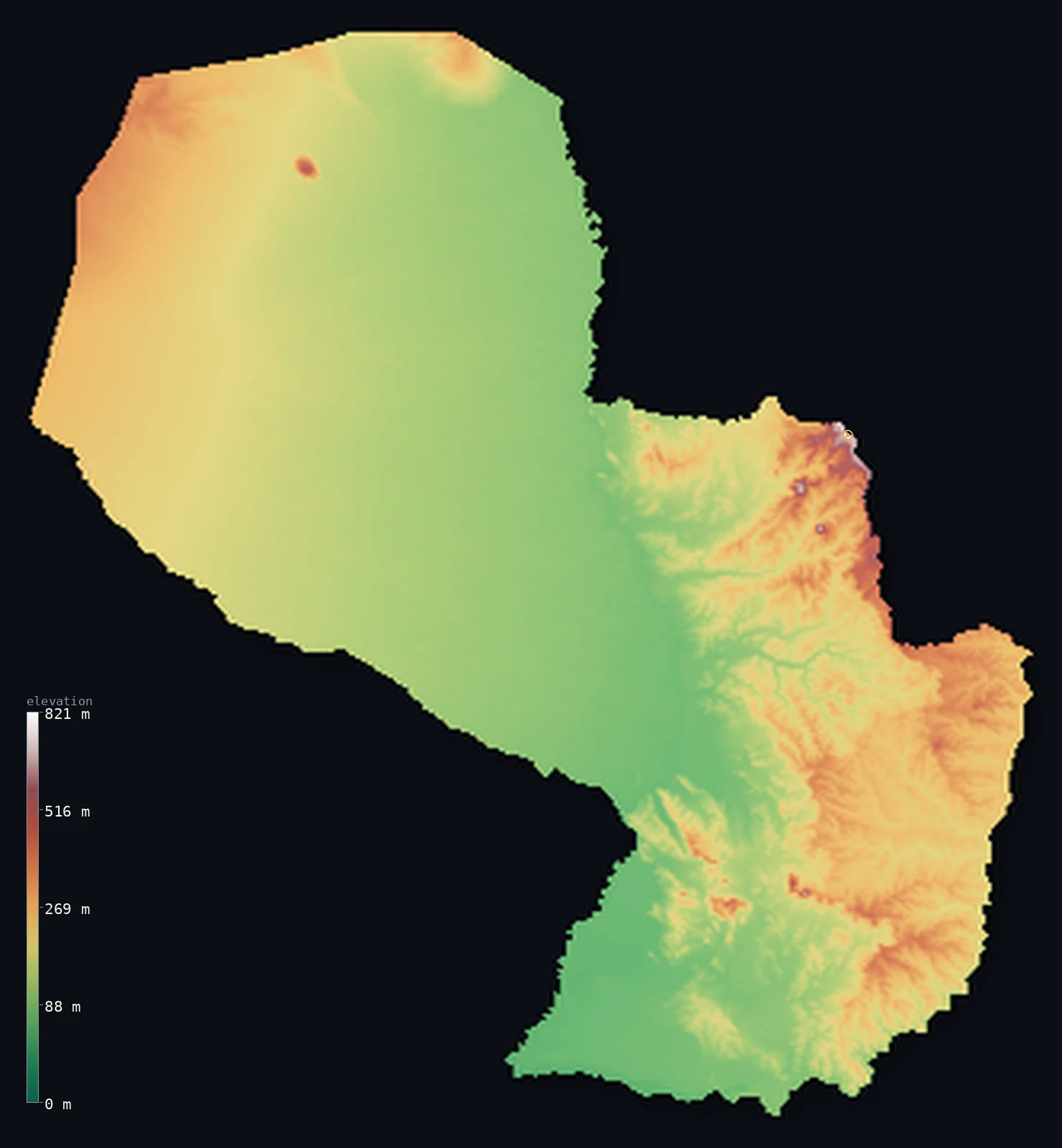
Paraguay’s highest point is Cerro Tres Kandu at 2,762 ft (842 m); its lowest is confluence of Rio Paraguay and Rio Parana at 151 ft (46 m); the mean elevation is 535 ft (163 m).
Paraguay is a low, landlocked country in the heart of South America, split in two by the Paraguay River. To the east lie low hills and fertile plains — the Paraná plateau country, greener and more populated, where nearly all Paraguayans live, rising to the country's modest high ground. To the west spreads the Gran Chaco: a vast, flat, dry lowland of scrub and marsh, thinly peopled, covering more than half the country. Paraguay has no mountains of any real height — its highest point, Cerro Peró, reaches only 2,762 ft (842 m) — and half the country lies below about 460 ft, in the Chaco and the river lowlands.
- Highest point📚
- 2,762 ft842 m
- Paraguay's highest point is Cerro Peró (also called Cerro Tres Kandú) at 2,762 ft (842 m), a hill in the Cordillera de Ybytyruzú of the eastern region — the modest high ground of the greener, hillier east, where the land rises gently above the surrounding plains. Paraguay has no true mountains: even its highest point is a low hill, and most of the country is lower still.
- Lowest point📚
- 151 ft46 m
- Paraguay's lowest point is at the confluence of the Paraguay and Paraná rivers in the far south, at about 151 ft (46 m) above sea level — where the country's great rivers, having gathered its waters, flow out toward the sea through Argentina. Landlocked Paraguay is low throughout, and its lowest ground is where the rivers leave it.
- Mean elevation⚙
- 535 ft163 m
- Computed from the GLO-30 model, Paraguay's mean elevation is 535 ft (163 m) — a low figure, for Paraguay is a low country: the vast, flat Chaco in the west and the river lowlands cover most of it, and even the hillier east rises only modestly, so half the country lies below about 459 ft (140 m), with no great heights to lift the average far.
- Median elevation⚙
- 459 ft140 m
- Half of Paraguay lies below about 459 ft (140 m) — a low figure, close to the mean, because the country is low and mostly flat: the great Chaco plain in the west and the river lowlands make up much of it, and the eastern hills, though a little higher, never rise to real mountains.
- Elevation range📚
- 2,612 ft796 m
- From the river confluence in the south to the hill of Cerro Peró at 842 m, Paraguay's terrain spans only about 2,600 ft — a small range for a large country, because Paraguay is low throughout: a flat Chaco west and a gently rolling east, with no mountains and little high ground.
- Official area📚
- 157,048 mi²406,752 km²
- Paraguay covers about 157,000 sq mi (406,752 sq km) — a low, landlocked South American country split by the Paraguay River into the greener, hillier east (where most people live) and the vast, flat, dry Gran Chaco of the west, with no mountains of real height.
- Forest cover📚
- 38.6%
- About 39% of Paraguay is forested — Atlantic forest remnants and farmland in the wetter east, and dry scrub and thorn forest across the Chaco in the west, much of it cleared for cattle.
Highest and lowest points
Paraguay's highest point is Cerro Peró — also known as Cerro Tres Kandú — at 2,762 ft (842 m), a forested hill in the Cordillera de Ybytyruzú in the eastern region. It is the high point of the low ranges of eastern Paraguay, where the land rises gently above the plains: not a mountain, but a hill, the tallest of the modest rises of the greener, more populated east. Paraguay has no true mountains at all — the vast Chaco of the west is flat lowland, and even the eastern hill country, the highest part of the nation, tops out at Cerro Peró's modest height. It is among the lowest-lying of South America's countries, a land of plains and rivers rather than peaks.
source ↗Paraguay's lowest point is at the confluence of the Paraguay and Paraná rivers in the far south, at about 151 ft (46 m) above sea level. Landlocked in the centre of South America, Paraguay is defined by these two great rivers, and above all by the Paraguay River, which runs north to south through the country and divides it in two. To the west lies the Gran Chaco — a vast, flat, dry lowland of scrub, thorn forest, and seasonal marsh, covering more than half the country but holding only a small share of its people. To the east lies the greener, more populated region: low hills and fertile plains, part of the Paraná plateau country, rising to Paraguay's modest high ground and holding the capital, Asunción, on the Paraguay River. There are no mountains of any real height anywhere in Paraguay; it is a low, riverine country, and its lowest point is where its rivers gather and flow out toward the distant sea.
source ↗Paraguay at a glance
Paraguay is split in two by the Paraguay River - the greener, hillier, populated east, and the vast, flat, dry Gran Chaco of the west, which covers more than half the country but holds few people.
source ↗Paraguay has no mountains of real height - its highest point, Cerro Peró, reaches only 842 m, and the country is low and mostly flat throughout.
source ↗The Gran Chaco of western Paraguay is one of South America's great wildernesses - a vast, hot, flat plain of scrub and thorn forest, shared with Bolivia and Argentina.
source ↗Landlocked Paraguay is defined by its rivers - the Paraguay and the Paraná - which gather its waters and carry them south toward the sea through Argentina.
source ↗Nearly all Paraguayans live in the eastern third of the country - the greener, hillier region east of the Paraguay River - while the vast Chaco west is nearly empty.
source ↗The Itaipú Dam on the Paraná River, on Paraguay's border with Brazil, is one of the largest hydroelectric plants in the world.
source ↗
Elevation profile of Paraguay
The largest share of land, 27%, falls in the 50–100 m band, and >99% of the territory lies below 500 m (1,640 ft).
- below 500 m (1,640 ft)>99%
- 500–1,000 m<1%
Highest peaks of Paraguay
| Peak | Elevation | Range | Note |
|---|---|---|---|
| Cerro Tres Kandu↗ | 2,762 ft842 m | Ybytyruzu (Guaira, southeast) | Highest point of Paraguay, a forested hill in the southeastern Ybytyruzu range. |
| Cerro de Acati↗ | 2,362 ft720 m | Eastern hills | One of the higher hills of eastern Paraguay. |
| Cerro Ponta Pora↗ | 2,297 ft700 m | Cordillera de Amambay (northeast, Brazil border) | A high point of the Amambay range on the northeastern border. |
Paraguay: the eastern hills, the Gran Chaco, and the rivers
The eastern region — hills and plains
East of the Paraguay River lies the greener, more populated part of the country — low hills and fertile plains, part of the Paraná plateau country, rising to Paraguay's modest high ground (Cerro Peró) and holding the capital, Asunción. The country's higher, wetter, populous side.
The Gran Chaco — the west
West of the river spreads the Gran Chaco — a vast, flat, dry lowland of scrub, thorn forest, and seasonal marsh, covering more than half of Paraguay but holding few people. The great empty plain of the west, shared with Bolivia and Argentina.
The rivers
The Paraguay River runs north–south through the country, dividing it, joined in the south by the Paraná along the Argentine border; together they gather Paraguay's waters and drain them south. The low riverine spine of a landlocked land.
How to read this map
Color shows elevation; the raised relief shows real terrain. On this map Paraguay reads as a low, mostly flat country — broad low tone across nearly all of it, the vast flat Gran Chaco in the west and the river lowlands, rising only gently to the low hills of the east (highest at Cerro Peró, and even that only a hill).
With so little relief, the 3D exaggeration is what makes the gentle eastern rise visible; the ×N relief slider controls how much. Tap anywhere to read that point's exact elevation.
City elevations in Paraguay
Paraguay's cities lie almost all in the eastern region — Asunción, the capital, on the Paraguay River, with Ciudad del Este on the Paraná at the Brazilian border and others across the greener east. The vast Chaco west holds only a few small, remote towns.
| City | Population | Elevation |
|---|---|---|
| Asuncióncapitalthe capital, on the Paraguay River ↗ | 1,482,200 | 351 ft107 m |
| Ciudad del Esteon the Paraná River at the Brazilian border ↗ | 301,815 | 640 ft195 m |
| Encarnaciónon the Paraná River in the south, at the Argentine border ↗ | 74,983 | 387 ft118 m |
| Caaguazúin the eastern interior ↗ | 54,808 | 1,089 ft332 m |
| Concepciónon the Paraguay River in the north ↗ | 48,123 | 262 ft80 m |
| Pilaron the Paraguay River in the far south ↗ | 32,810 | 187 ft57 m |
| Yby Yaúin the northeastern interior ↗ | 31,290 | 597 ft182 m |
| Caazapáin the southeastern hill country ↗ | 23,996 | 489 ft149 m |
Elevation sampled at each city centre from the Copernicus GLO-30 model. Cities and population from GeoNames (CC-BY 4.0).
Paraguay in comparison
Paraguay's terrain rises 2,612 ft (796 m) from confluence of Rio Paraguay and Rio Parana (151 ft (46 m)) to Cerro Tres Kandu — about 9% of the height of Mount Everest, the world's highest point at 29,032 ft (8,849 m).
- Argentina's mean elevation is 2,323 ft — 1,788 ft higher; its high point, Cerro Aconcagua, reaches 22,838 ft (6,961 m), 20,075 ft above. Argentina elevation map →
- Bolivia's mean elevation is 4,042 ft — 3,507 ft higher; its high point, Nevado Sajama, reaches 21,463 ft (6,542 m), 18,701 ft above. Bolivia elevation map →
- Brazil's mean elevation is 1,050 ft — 515 ft higher; its high point, Pico da Neblina, reaches 9,826 ft (2,995 m), 7,064 ft above. Brazil elevation map →
- Uruguay's mean elevation is 361 ft — 174 ft lower; its high point, Cerro Catedral, reaches 1,686 ft (514 m), 1,076 ft below. Uruguay elevation map →
Frequently asked questions
What is the highest point in Paraguay?
- Cerro Peró (Cerro Tres Kandú), 2,762 ft (842 m), a hill in the eastern Cordillera de Ybytyruzú - not a mountain; Paraguay has no true mountains.
What is the lowest point in Paraguay?
- The confluence of the Paraguay and Paraná rivers in the far south, about 151 ft (46 m) above sea level - where the country's rivers flow out toward the sea.
What is the average elevation of Paraguay?
- Computed from the Copernicus GLO-30 model, the area-weighted mean is 535 ft (163 m) - low, because Paraguay is a low country: the flat Chaco and the river lowlands cover most of it, with no mountains to lift the average.
Is Paraguay flat?
- Mostly - the vast Gran Chaco of the west is flat, dry lowland, and the river lowlands are low; only the eastern region has hills, and even its highest point is just an 842 m hill. Paraguay has no true mountains.
Is this a topographic, relief, contour, or elevation map of Paraguay?
- They describe the same thing - terrain height. This page renders the country's actual elevation surface in interactive 3D and reports the statistics computed from it.
About this map
The terrain is rendered from the Copernicus GLO-30 digital elevation model (ESA), masked to the PRY-ADM0 boundary from geoBoundaries (gbOpen). Elevation statistics are computed directly from the model; peak names and researched facts are sourced and cited. See the methodology for the full pipeline.
Our area-weighted mean, computed from the Copernicus GLO-30 model, is 535 ft (163 m); the figure commonly cited elsewhere is 584 ft (178 m) (CIA World Factbook). Paraguay is a low country with no real high ground. The vast Gran Chaco — flat, dry lowland — fills the western more-than-half of it, and the river lowlands run through the rest; even the greener eastern hills, where nearly everyone lives, rise only modestly, to a highest point of just 842 m. So the mean and median are both low and close together: half the country lies below about 459 ft (140 m). There is no mountain range here to lift the average — only plains, marsh, and low hills.
Surveyed national figures: official area · forest cover · high point.
Rendered from Copernicus GLO-30 (ESA, 2021 release), boundaries from geoBoundaries. Generated 2026-06-26.
Bordering countries · 3
Paraguay shares a land border with these countries — open any one to compare its terrain and highest point.