Panama Elevation Map — Topographic & 3D Terrain
Explore the terrain of Panama in interactive 3D, built from Copernicus GLO-30 satellite elevation data — the low, S-shaped isthmus linking two continents, crossed by the Canal. Drag to rotate, scroll to zoom, and tap any point to read its elevation.
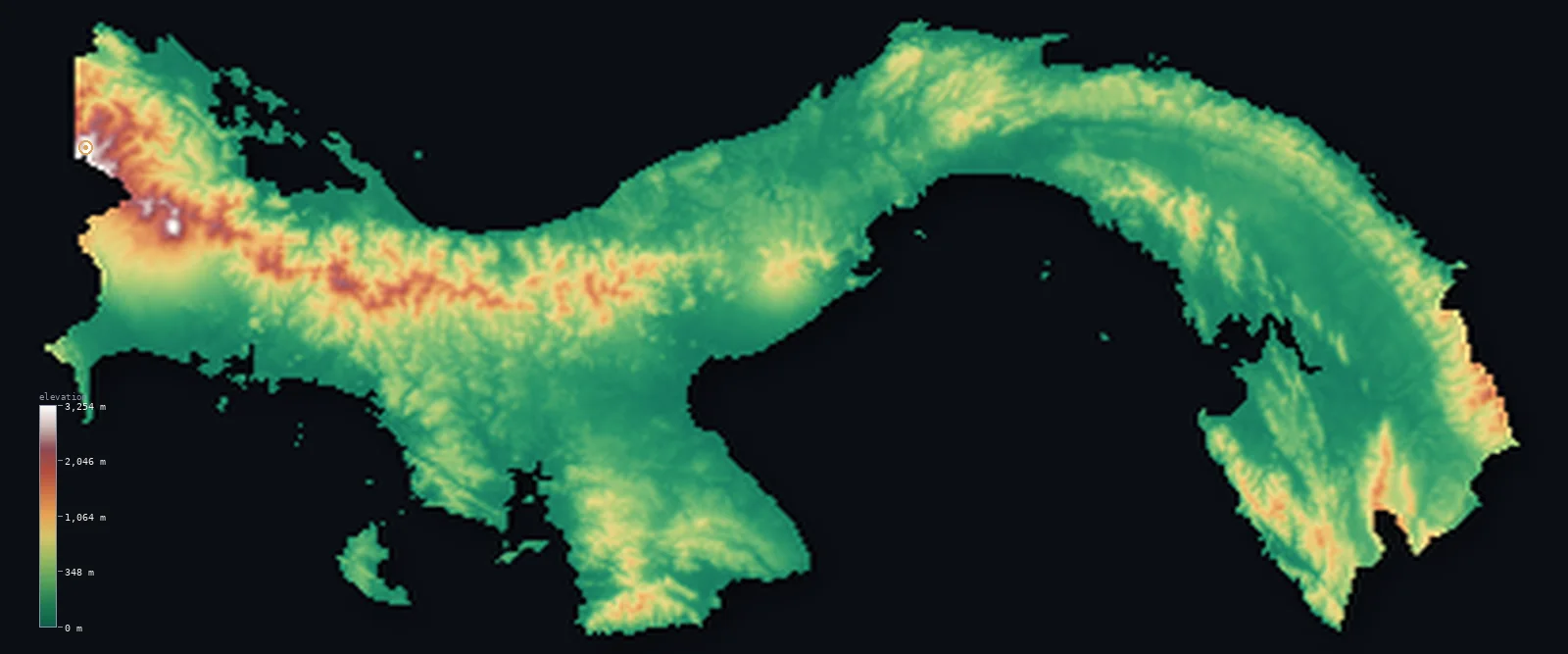
Panama’s highest point is Volcan Baru at 11,401 ft (3,475 m); its lowest is Pacific Ocean at 0 ft (0 m); the mean elevation is 1,017 ft (310 m).
Panama is the narrow, S-shaped isthmus that links Central and South America and divides the Atlantic from the Pacific. It is mostly low: a spine of hills and mountains runs along its length, but broad, low coastal lowlands lie on both the Caribbean and Pacific sides, and about half the country lies below about 500 ft. The central spine dips low enough near the middle for the Panama Canal to cross the continental divide — one of the lowest points in the entire mountain chain of the Americas. The high ground is at the two ends: in the west, near Costa Rica, the volcano Barú rises to 11,401 ft (3,475 m), the country's highest point; in the east lies the roadless jungle of the Darién.
- Highest point📚
- 11,401 ft3,475 m
- Panama's highest point is the Volcán Barú at 11,401 ft (3,475 m), in the western highlands near the Costa Rican border — a dormant volcano and the highest ground in the country, rising above the coffee highlands of Chiriquí. From its summit, on a rare clear day, both the Caribbean and the Pacific can be seen. The rest of Panama is far lower: a low isthmus of hills and coastal plains.
- Lowest point📚
- 0 ft0 m
- Panama's lowest point is the sea at sea level, on both coasts — the Caribbean to the north and the Pacific to the south, which along Panama's S-shaped isthmus lie surprisingly close together. Much of the country is low coastal lowland on one side or the other of the central spine.
- Mean elevation⚙
- 1,017 ft310 m
- Computed from the GLO-30 model, Panama's mean elevation is 1,017 ft (310 m) — low, and well above the median of 495 ft (151 m): the country is mostly low coastal lowland and hills, and only the western highlands around Volcán Barú stand high enough to pull the average up.
- Median elevation⚙
- 495 ft151 m
- Half of Panama lies below about 495 ft (151 m) — a very low figure, reflecting a country that is mostly low: broad coastal lowlands on both seas and low interior hills make up most of it, with only the western highlands around Volcán Barú standing high.
- Elevation range📚
- 11,401 ft3,475 m
- From either coast to the summit of Volcán Barú at 3,475 m, Panama's terrain climbs about 11,401 ft — but the country is mostly low: the rise is concentrated in the far western highlands, above a low isthmus of coastal plains and hills where the Canal crosses a low continental divide.
- Above 1,000 m (3,281 ft)⚙
- 7%
- About 7% of Panama rises above 1,000 m (3,281 ft) — chiefly the western highlands around Volcán Barú and the higher interior ranges; even 500 m (1,640 ft) is cleared by only 19% of the country. Most of Panama — the broad coastal lowlands on both seas — lies well below.
- Official area📚
- 29,119 mi²75,417 km²
- Panama covers about 29,100 sq mi (75,417 sq km) — the low, S-shaped isthmus linking Central and South America, mostly low coastal lowlands and hills, crossed near its centre by the Panama Canal at a low continental divide, rising to the volcano Barú in the west and holding the roadless Darién jungle in the east.
- Forest cover📚
- 43.6%
- About 44% of Panama is forested — extensive tropical rainforest, densest in the roadless Darién of the east and along the Caribbean coast, with the interior and the Pacific side more cleared and farmed.
Highest and lowest points
Panama's highest point is the Volcán Barú, 11,401 ft (3,475 m), a dormant volcano in the western province of Chiriquí, near the border with Costa Rica. It stands high above the low country around it — a solitary volcano rising over the cool coffee-growing highlands of the west. Elsewhere Panama is low: a central spine of hills and low mountains runs the length of the isthmus, all of it far lower, and near the middle the spine sinks low enough for the Panama Canal to cross the continental divide. The far east, the Darién, is low, wet, roadless jungle. So Barú, in the far west, is the country's greatest height.
source ↗Panama's lowest point is the sea at sea level, and much of the country lies close to it, on one coast or the other. Panama is the S-shaped isthmus joining Central and South America — a narrow land between the Caribbean to the north and the Pacific to the south, the two oceans lying close together across it. A spine of hills and low mountains runs along its length, but it is mostly low: broad coastal lowlands spread on both sides. Near the middle, the central spine dips low enough that the Panama Canal, opened in 1914, crosses the continental divide through it — cutting between the Atlantic and Pacific at one of the lowest points in the entire mountain chain of the Americas. Only at the country's western and eastern ends does it rise or thicken: the volcanic highlands by Costa Rica, and the dense roadless Darién jungle toward Colombia.
source ↗Panama at a glance
Panama is the low, S-shaped isthmus linking Central and South America - mostly low coastal lowlands and hills, with the Panama Canal crossing a low point in the continental divide near its centre.
source ↗Panama's highest point, the Volcán Barú (3,475 m), is a dormant volcano in the west - from its summit, on a clear day, both the Caribbean and the Pacific can be seen.
source ↗The Panama Canal crosses the continental divide at one of the lowest points in the entire mountain chain of the Americas - low enough to link the Atlantic and Pacific by water.
source ↗Because of Panama's S-shape, the sun rises over the Pacific and sets over the Caribbean along parts of the isthmus - the country runs more east-west than north-south.
source ↗The Darién, in eastern Panama toward Colombia, is a vast roadless jungle - the only break in the Pan-American Highway, the famous 'Darién Gap.'
source ↗About half of Panama lies below about 150 m - a mostly low country, its one great height the western volcano Barú.
source ↗
Elevation profile of Panama
The largest share of land, 63%, falls in the 0–250 m band, and 81% of the territory lies below 500 m (1,640 ft).
- below 500 m (1,640 ft)81%
- 500–1,000 m12%
- 1,000–2,000 m6%
- above 2,000 m (6,562 ft)1%
Highest peaks of Panama
| Peak | Elevation | Range | Note |
|---|---|---|---|
| Volcan Baru↗ | 11,401 ft3,475 m | Cordillera de Talamanca (west, Chiriqui) | Highest point of Panama, a dormant stratovolcano with views of both oceans. |
| Cerro Fabrega↗ | 10,945 ft3,336 m | Cordillera de Talamanca (west, La Amistad) | A high peak of the Talamanca near the Costa Rican border in La Amistad park. |
| Cerro Santiago↗ | 9,272 ft2,826 m | Serrania de Tabasara (central-west) | The high point of the Tabasara range in the Ngabe-Bugle highlands. |
| Cerro Tacarcuna↗ | 6,152 ft1,875 m | Serrania del Darien (east, Colombia border) | The highest peak of eastern Panama, in the Darien on the Colombian border. |
| Cerro Hoya↗ | 5,115 ft1,559 m | Azuero Peninsula (south) | The high point of the southern Azuero Peninsula. |
Panama: the central spine and the Canal, the coastal lowlands, and the western highlands and eastern Darién
The central spine and the Canal
A spine of hills and low mountains runs the length of the isthmus — the Cordillera Central and lower ranges — but dips near the middle, where the Panama Canal crosses the continental divide at a low saddle. The country's low mountainous backbone, cut by the Canal.
The coastal lowlands
Broad low lowlands lie on both coasts — the Caribbean to the north and the Pacific to the south (the more populated side, holding Panama City) — close together across the narrow isthmus. The low, warm margins that make up much of the country.
The western highlands and the eastern Darién
At the two ends the country rises or thickens — in the west, the volcanic highlands of Chiriquí around Volcán Barú (the high point); in the east, the vast roadless jungle of the Darién toward Colombia. The high western volcano and the wild eastern forest, at the isthmus's ends.
How to read this map
Color shows elevation; the raised relief shows real terrain. On this map Panama reads as a low, narrow, S-shaped isthmus — broad low green along both coasts and across much of the interior, a low central spine of hills running its length (dipping where the Canal crosses near the middle), rising sharply only in the far west to the brown cone of Volcán Barú (the high point), with the low forested Darién filling the east.
The 3D relief is the actual GLO-30 elevation data, exaggerated vertically so the low isthmus and the western volcano both show; the ×N relief slider controls how much. Tap anywhere to read that point's exact elevation.
City elevations in Panama
Panama's cities cluster on the Pacific side and along the Canal — Panama City, the capital, at the Pacific end of the Canal, Colón at its Caribbean end, and David in the west toward Costa Rica. Most of the population lies low, near the Canal and the Pacific coast.
| City | Population | Elevation |
|---|---|---|
| Panama Citycapitalthe capital, at the Pacific end of the Panama Canal ↗ | 408,168 | 49 ft15 m |
| Davidthe main western city, in Chiriquí toward Costa Rica ↗ | 82,907 | 151 ft46 m |
| Colónat the Caribbean end of the Canal ↗ | 78,000 | 13 ft4 m |
| Santiago de Veraguasin the central interior (Veraguas) ↗ | 45,355 | 322 ft98 m |
| Changuinolain the northwest (Bocas del Toro), near the Caribbean ↗ | 17,997 | 36 ft11 m |
| Penonoméin the central Pacific lowlands (Coclé) ↗ | 16,250 | 292 ft89 m |
| Chepoeast of Panama City, toward the Darién ↗ | 12,912 | 62 ft19 m |
| San Juan Bautistaon the Azuero Peninsula, on the Pacific side ↗ | 11,798 | 85 ft26 m |
| Puerto Armuelleson the far western Pacific coast, near Costa Rica ↗ | 11,743 | 36 ft11 m |
| Volcánin the western highlands, on the slopes of Volcán Barú ↗ | 10,286 | 4,623 ft1,409 m |
Elevation sampled at each city centre from the Copernicus GLO-30 model. Cities and population from GeoNames (CC-BY 4.0).
Panama in comparison
Panama's terrain rises 11,401 ft (3,475 m) from sea level to Volcan Baru — about 39% of the height of Mount Everest, the world's highest point at 29,032 ft (8,849 m).
- Costa Rica's mean elevation is 1,844 ft — 827 ft higher; its high point, Cerro Chirripó, reaches 12,536 ft (3,821 m), 1,135 ft above. Costa Rica elevation map →
- Colombia's mean elevation is 1,834 ft — 817 ft higher; its high point, Pico Cristóbal Colón, reaches 18,947 ft (5,775 m), 7,546 ft above. Colombia elevation map →
- Nicaragua's mean elevation is 728 ft — 289 ft lower; its high point, Mogoton, reaches 6,913 ft (2,107 m), 4,488 ft below. Nicaragua elevation map →
- Mexico's mean elevation is 3,415 ft — 2,398 ft higher; its high point, Pico de Orizaba (Citlaltepetl), reaches 18,491 ft (5,636 m), 7,090 ft above. Mexico elevation map →
Frequently asked questions
What is the highest point in Panama?
- The Volcán Barú, 11,401 ft (3,475 m), a dormant volcano in the western highlands near Costa Rica - the one great height in a mostly low country.
What is the lowest point in Panama?
- Sea level, on both coasts - the Caribbean and the Pacific, which lie close together across the narrow S-shaped isthmus.
What is the average elevation of Panama?
- Computed from the Copernicus GLO-30 model, the area-weighted mean is 1,017 ft (310 m) - low, and higher than the typical point; about half of Panama lies below about 495 ft (151 m), since the country is mostly low coastal lowland and hills.
How does the Panama Canal cross the mountains?
- The central spine of the isthmus dips low near the middle of the country, and the Canal crosses the continental divide there - at one of the lowest points in the entire mountain chain of the Americas.
Is Panama flat?
- Mostly low, not flat - broad coastal lowlands and low interior hills make up much of it, but a central spine of hills runs its length and the volcano Barú rises to 3,475 m in the west. Half the country lies below about 150 m.
Is this a topographic, relief, contour, or elevation map of Panama?
- They describe the same thing - terrain height. This page renders the country's actual elevation surface in interactive 3D and reports the statistics computed from it.
About this map
The terrain is rendered from the Copernicus GLO-30 digital elevation model (ESA), masked to the PAN-ADM0 boundary from geoBoundaries (gbOpen). Elevation statistics are computed directly from the model; peak names and researched facts are sourced and cited. See the methodology for the full pipeline.
Our area-weighted mean, computed from the Copernicus GLO-30 model, is 1,017 ft (310 m); the figure commonly cited elsewhere is 1,181 ft (360 m) (CIA World Factbook). Panama is a low, narrow isthmus — a central spine of hills, dipping to a low saddle at the Canal, between broad coastal lowlands on both seas — so it is mostly low: half the country lies below about 495 ft (151 m). The area-weighted mean computed here from GLO-30 sits a little below the figure commonly cited, and well above the median, lifted by the one western volcano, Barú.
Surveyed national figures: official area · forest cover · high point.
Rendered from Copernicus GLO-30 (ESA, 2021 release), boundaries from geoBoundaries. Generated 2026-06-26.
Bordering countries · 2
Panama shares a land border with these countries — open any one to compare its terrain and highest point.