Mexico Elevation Map — Topographic & 3D Terrain
Explore the terrain of Mexico in interactive 3D, built from Copernicus GLO-30 satellite elevation data — a raised volcanic table between two mountain ranges. Drag to rotate, scroll to zoom, and tap any point to read its elevation.
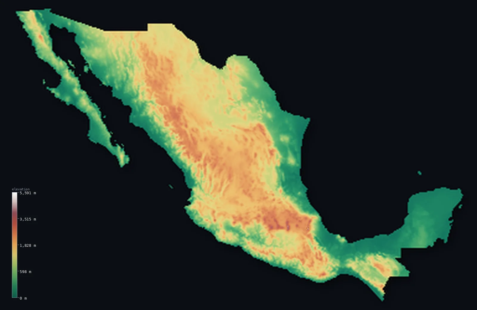
Mexico’s highest point is Pico de Orizaba (Citlaltepetl) at 18,491 ft (5,636 m); its lowest is Laguna Salada at −33 ft (−10 m); the mean elevation is 3,415 ft (1,041 m).
Mexico lives high. Its heart is the Mexican Plateau, a vast raised table held between the two Sierra Madre ranges, and it sits high enough that the country's median elevation — 3,409 ft (1,039 m) — is almost identical to its mean: this is not a land of extremes averaging out, but a country genuinely lifted. Across its southern edge runs a belt of great volcanoes, crowned by Pico de Orizaba at 18,491 ft (5,636 m).
- Highest point📚
- 18,491 ft5,636 m
- Mexico's highest point is Pico de Orizaba (Citlaltépetl) at 18,491 ft (5,636 m), a snow-capped stratovolcano rising from the eastern end of the volcanic belt — the third-highest peak in North America, and high enough to carry glaciers at tropical latitude.
- Lowest point📚
- −33 ft−10 m
- Mexico's lowest point is the Laguna Salada basin in Baja California, about 33 ft (10 m) below sea level — a dry lake bed in the desert near the Colorado River delta that fills only rarely.
- Mean elevation⚙
- 3,415 ft1,041 m
- Mexico's mean elevation computed from the GLO-30 model is 3,415 ft (1,041 m) — high, and the direct product of the Mexican Plateau, which fills the country's interior at between 1,000 and 2,000 m.
- Median elevation⚙
- 3,409 ft1,039 m
- Half of Mexico lies above 3,409 ft (1,039 m) — almost exactly the mean, which is unusual and revealing: rather than balancing high peaks against low plains, Mexico simply sits up on a plateau, with the typical point in the country already a kilometre above the sea.
- Elevation range📚
- 18,524 ft5,646 m
- From the Laguna Salada below sea level to the summit of Pico de Orizaba, Mexico spans about 18,520 ft — the sweep from Sonoran desert floor to a glaciated volcanic cone standing above the tropics.
- Above 1,000 m (3,281 ft)⚙
- 51%
- About 51% of Mexico lies above 1,000 m (3,281 ft) — more than half the country, essentially the whole plateau interior and the flanking Sierra Madre ranges, leaving only the coastal plains and the Yucatán below.
- Above 2,000 m (6,562 ft)⚙
- 16%
- Roughly 16% of Mexico stands above 2,000 m (6,562 ft) — the higher plateau and the volcanic belt across the country's waist, where Mexico City itself sits at more than 2,200 m.
- Official area📚
- 758,449 mi²1,964,375 km²
- Mexico covers about 758,000 sq mi (1.96 million sq km) — from the deserts of the north through the raised plateau to the tropical isthmus and the flat limestone shelf of the Yucatán.
- Forest cover📚
- 33%
- About 33% of Mexico is forested — pine and oak on the cool slopes of the Sierra Madre, tropical forest in the humid south, and almost nothing across the northern deserts.
Highest and lowest points
Mexico's highest point is Pico de Orizaba, also called Citlaltépetl, at 18,491 ft (5,636 m) — a dormant stratovolcano at the eastern end of the Trans-Mexican Volcanic Belt and the third-highest mountain in North America. It is high enough to hold glaciers despite sitting at tropical latitude, and its cone is visible from the Gulf coast far below. Published heights differ slightly: Mexican and other sources cite about 5,610 m, while the figure shown here is the commonly published 5,636 m.
source ↗Mexico's lowest point is the Laguna Salada in Baja California, a dry lake bed lying about 33 ft (10 m) below sea level near the mouth of the Colorado River. For most of the time it is a flat, salt-crusted desert floor; only in rare wet years does water reach it and turn it briefly into a lake. On this elevation model the basin reads shallower than its surveyed depth; the figure shown is the surveyed value.
source ↗Mexico at a glance
Pico de Orizaba, 5,636 m, is the third-highest peak in North America and carries glaciers despite standing at tropical latitude.
source ↗More than half of Mexico lies above 1,000 m - the country's interior is the Mexican Plateau, a raised table held between the Sierra Madre Occidental and Oriental.
source ↗Mexico City sits at more than 2,200 m in a high basin of the volcanic belt, one of the highest large cities in the world.
source ↗The Trans-Mexican Volcanic Belt runs across the country's waist and carries its highest peaks, including Popocatépetl, which remains active.
source ↗The Yucatán Peninsula is a flat limestone shelf with almost no surface rivers - its water runs underground through caves and cenotes.
source ↗Mexico's lowest point, the Laguna Salada in Baja California, is a desert lake bed about 10 m below sea level that is usually dry.
source ↗
Elevation profile of Mexico
The largest share of land, 36%, falls in the 0–500 m band, and 64% of the territory lies above 500 m (1,640 ft).
- below 500 m (1,640 ft)36%
- 500–1,000 m13%
- 1,000–2,000 m35%
- above 2,000 m (6,562 ft)16%
Highest peaks of Mexico
| Peak | Elevation | Range | Note |
|---|---|---|---|
| Pico de Orizaba (Citlaltepetl)↗ | 18,491 ft5,636 m | Trans-Mexican Volcanic Belt (Veracruz/Puebla) | Highest point of Mexico and the highest volcano in North America, glacier-capped. |
| Popocatepetl↗ | 17,694 ft5,393 m | Trans-Mexican Volcanic Belt (central) | An active volcano southeast of Mexico City, the country's second-highest peak. |
| Iztaccihuatl↗ | 17,159 ft5,230 m | Trans-Mexican Volcanic Belt (central) | A dormant volcano beside Popocatepetl, third-highest in Mexico. |
| Nevado de Toluca (Xinantecatl)↗ | 15,354 ft4,680 m | Trans-Mexican Volcanic Belt (Mexico State) | A volcano west of Mexico City with a crater holding two lakes. |
| La Malinche (Matlalcueitl)↗ | 14,636 ft4,461 m | Trans-Mexican Volcanic Belt (Tlaxcala/Puebla) | A dormant volcano rising alone from the plateau between Puebla and Tlaxcala. |
The shape of Mexico
The Mexican Plateau and the Sierra Madre
The interior of Mexico is a single vast raised plateau, tilting up from north to south between two great ranges — the Sierra Madre Occidental on the west and the Sierra Madre Oriental on the east. This is where most Mexicans live, a kilometre or more above the sea, and it is what makes the country high on average.
The Trans-Mexican Volcanic Belt
Across the waist of the country runs a belt of great volcanoes — Orizaba, Popocatépetl, Iztaccíhuatl, Nevado de Toluca — carrying every one of Mexico's highest summits. Mexico City lies in a high basin among them, ringed by cones.
The coasts, the isthmus and Yucatán
Below the plateau lie narrow coastal plains on the Pacific and the Gulf, widening in the south toward the tropical isthmus. Farther east the Yucatán Peninsula spreads out as a low, flat limestone shelf — the one large piece of Mexico with no relief at all.
How to read this map
Color shows elevation; the raised relief shows real terrain. On this map Mexico reads as a raised brown interior between two darker mountain walls, with the sharp white points of the volcanoes across its middle and flat green at the coasts and Yucatán.
The 3D relief is the actual GLO-30 elevation data, exaggerated vertically so the plateau and the volcanic cones both show; the ×N relief slider controls how much. Tap anywhere to read that point's exact elevation.
City elevations in Mexico
Mexican cities sit high because the country does. Mexico City stands at more than 7,300 ft in a basin of the volcanic belt, and Querétaro and the other plateau cities are not far below — while Mérida on the flat Yucatán and the coastal ports sit barely above the sea.
| City | Population | Elevation |
|---|---|---|
| Mexico Citycapitalthe capital, in a high basin of the volcanic belt at about 2,240 m, ringed by volcanoes ↗ | 12,294,193 | 7,323 ft2,232 m |
| Tijuana | 1,922,523 | 315 ft96 m |
| Santiago de Querétaroon the central plateau at about 1,820 m, in the heart of the raised interior ↗ | 1,594,212 | 5,984 ft1,824 m |
| León de los Aldama | 1,579,803 | 5,932 ft1,808 m |
| Ciudad Juárez | 1,512,450 | 3,707 ft1,130 m |
| Zapopan | 1,476,491 | 5,144 ft1,568 m |
| Méridaon the flat limestone shelf of the Yucatán, barely above sea level ↗ | 1,201,000 | 49 ft15 m |
| Monterrey | 1,135,512 | 1,778 ft542 m |
| Mexicali | 1,032,686 | 16 ft5 m |
| Chihuahua | 925,762 | 4,718 ft1,438 m |
Elevation sampled at each city centre from the Copernicus GLO-30 model. Cities and population from GeoNames (CC-BY 4.0).
Mexico in comparison
Mexico's terrain rises 18,524 ft (5,646 m) from Laguna Salada, 33 ft (10 m) below sea level to Pico de Orizaba (Citlaltepetl) — about 64% of the height of Mount Everest, the world's highest point at 29,032 ft (8,849 m).
- United States's mean elevation is 2,569 ft — 846 ft lower; its high point, Denali, reaches 20,308 ft (6,190 m), 1,818 ft above. United States elevation map →
- Guatemala's mean elevation is 2,444 ft — 971 ft lower; its high point, Volcan Tajumulco, reaches 13,845 ft (4,220 m), 4,646 ft below. Guatemala elevation map →
- Belize's mean elevation is 539 ft — 2,876 ft lower; its high point, Doyle's Delight, reaches 3,688 ft (1,124 m), 14,803 ft below. Belize elevation map →
Frequently asked questions
What is the highest point in Mexico?
- Pico de Orizaba (Citlaltépetl), 18,491 ft (5,636 m), a glaciated volcano at the eastern end of the volcanic belt - the third-highest peak in North America. Some Mexican sources cite about 5,610 m.
What is the lowest point in Mexico?
- The Laguna Salada in Baja California, a usually-dry desert lake bed about 33 ft (10 m) below sea level.
What is the average elevation of Mexico?
- Computed from the Copernicus GLO-30 model, the area-weighted mean is 3,415 ft (1,041 m) - high, because the Mexican Plateau fills the country's interior above 1,000 m.
Why is Mexico City so high?
- It sits in a basin of the Trans-Mexican Volcanic Belt at more than 2,200 m, ringed by volcanoes - one of the highest large cities in the world.
Is Mexico mountainous or flat?
- Both, but mostly high: about half the country lies above 1,000 m on the plateau and the Sierra Madre, while the coastal plains and the Yucatán Peninsula are low and flat.
Is this a topographic, relief, contour, or elevation map of Mexico?
- They describe the same thing - terrain height. This page renders the country's actual elevation surface in interactive 3D and reports the statistics computed from it.
About this map
The terrain is rendered from the Copernicus GLO-30 digital elevation model (ESA), masked to the MEX-ADM0 boundary from geoBoundaries (gbOpen). Elevation statistics are computed directly from the model; peak names and researched facts are sourced and cited. See the methodology for the full pipeline.
Our area-weighted mean, computed from the Copernicus GLO-30 model, is 3,415 ft (1,041 m); the figure commonly cited elsewhere is 3,645 ft (1,111 m) (CIA World Factbook). Mexico is dominated by a high central plateau (the Altiplano) flanked by the Sierra Madre ranges, with coastal plains and the volcanic belt rising far higher, so its mean elevation is high; the page reports the area-weighted figure computed from the Copernicus GLO-30 model.
Surveyed national figures: official area · forest cover · high point.
Rendered from Copernicus GLO-30 (ESA, 2021 release), boundaries from geoBoundaries. Generated 2026-06-24.
Bordering countries · 3
Mexico shares a land border with these countries — open any one to compare its terrain and highest point.