Guatemala Elevation Map — Topographic & 3D Terrain
Explore the terrain of Guatemala in interactive 3D, built from Copernicus GLO-30 satellite elevation data — a country of volcanic highlands between two coastal lowlands, crowned by the highest peak in Central America. Drag to rotate, scroll to zoom, and tap any point to read its elevation.
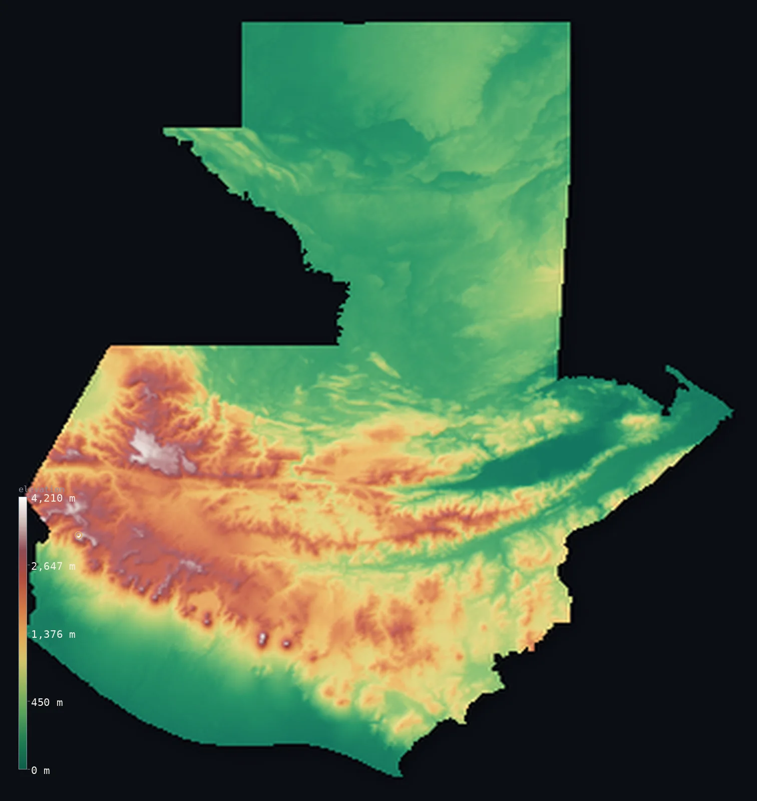
Guatemala’s highest point is Volcan Tajumulco at 13,845 ft (4,220 m); its lowest is Pacific Ocean at 0 ft (0 m); the mean elevation is 2,444 ft (745 m).
Guatemala holds the highest summit in Central America, yet most of the country is low-lying. A spine of volcanic highlands — the Sierra Madre and the central cordillera — runs across its southern half, a chain of steep ridges and great volcanoes that includes Tajumulco, at 13,845 ft (4,220 m) the highest peak in all of Central America. But most of the country is lower: the broad, flat limestone lowlands of the Petén spread across the north toward the Maya ruins and the Yucatán, and a hot plain runs along the Pacific coast in the south, with a shorter Caribbean lowland in the east. So while the volcanic highlands hold most of the people and the country's great peaks, half of Guatemala lies below about 1,100 ft — a highland minority above a lowland majority.
- Highest point📚
- 13,845 ft4,220 m
- Guatemala's highest point is Tajumulco at 13,845 ft (4,220 m), a volcano in the Sierra Madre of the western highlands — and the highest peak in all of Central America. It rises above a region of great volcanoes, several of them active, including nearby Tacaná on the Mexican border and, further southeast, the constantly erupting Fuego above the old colonial city of Antigua. Tajumulco is the tallest of them all, and the high point of the isthmus between Mexico and Panama.
- Lowest point📚
- 0 ft0 m
- Guatemala's lowest point is the Pacific Ocean at sea level, along the hot, fertile plain of the country's southern coast — with the Caribbean Sea, reached through the Gulf of Honduras in the east, the other sea-level low. From both coasts the land rises toward the volcanic highlands of the interior.
- Mean elevation⚙
- 2,444 ft745 m
- Computed from the GLO-30 model, Guatemala's mean elevation is 2,444 ft (745 m) — but the mean is misleading here, lifted by the high volcanic peaks: half the country actually lies below about 1,099 ft (335 m), because the broad Petén lowlands in the north and the coastal plains are low, and it is the volcanic highlands of the south that, though they hold most of the people, are the high minority raising the average.
- Median elevation⚙
- 1,099 ft335 m
- Half of Guatemala lies below about 1,099 ft (335 m) — a figure well below the mean, and the truer measure of the country: the low limestone lowlands of the Petén and the two coastal plains cover much of it, while the volcanic highlands of the south, high and steep, are a minority of the area that lifts the mean above the median.
- Elevation range📚
- 13,845 ft4,220 m
- From the Pacific coast to the summit of Tajumulco at 4,220 m, Guatemala's terrain climbs about 13,845 ft — the full sweep from a tropical sea-level coast to the highest volcanic summit in Central America, across a country that is mostly low but crowned by a high volcanic spine.
- Above 1,000 m (3,281 ft)⚙
- 30%
- About 30% of Guatemala rises above 1,000 m (3,281 ft) — the volcanic highlands of the south and west, the Sierra Madre and the central cordillera, where most Guatemalans live. The Petén lowlands of the north and the coastal plains lie well below.
- Above 2,000 m (6,562 ft)⚙
- 10%
- Roughly 10% of Guatemala stands above 2,000 m (6,562 ft) — the higher volcanic highlands, the great peaks and high basins around the western Sierra Madre, the country's highest and most densely settled ground.
- Official area📚
- 42,042 mi²108,889 km²
- Guatemala covers about 42,000 sq mi (108,889 sq km) — a Central American country between the Pacific and the Caribbean, of volcanic highlands (holding Tajumulco, the highest peak in Central America) across the south, the broad low Petén limestone lowlands in the north, and coastal plains on both seas.
- Forest cover📚
- 33%
- About 33% of Guatemala is forested — tropical rainforest across the low Petén in the north (part of the great Maya Forest), cloud forest on the highland slopes, and drier woodland and farmland through the volcanic highlands and the Pacific piedmont.
Highest and lowest points
Guatemala's highest point is Tajumulco, 13,845 ft (4,220 m), a volcano in the Sierra Madre of the far western highlands, near the Mexican border — and the highest mountain in all of Central America, higher than any peak from Guatemala to Panama. It is one of a chain of great volcanoes that runs across southern Guatemala, several of them active: Tacaná, on the Mexican frontier, is nearly as high; Fuego, near Antigua, is one of the most active volcanoes in the Americas, erupting almost constantly; and Atitlán rises above the famous lake of the same name. Tajumulco itself is dormant. The western highlands around it are the highest and most densely populated part of the country, a region of high volcanic basins and steep ridges — the heart of Guatemala's Maya highlands. Nothing between Mexico and the Andes stands higher.
source ↗Guatemala's lowest point is the Pacific Ocean at sea level, along the hot, fertile volcanic-soil plain of the south coast, where much of the country's coffee, sugar, and bananas grow. The country also reaches the Caribbean Sea in the east, through the Gulf of Honduras, giving it two coasts. Between them rises the volcanic highland spine that defines Guatemala — the Sierra Madre and the central cordillera, a chain of steep mountains and great volcanoes running from the Mexican border southeast toward El Salvador. North of the highlands the land falls away entirely into the Petén: a vast, low, flat expanse of limestone, forest, and Maya ruins, stretching toward Mexico and Belize. So the land drops both ways from the highlands — south to the Pacific, north to the Petén and the Caribbean.
source ↗Guatemala at a glance
Guatemala's Tajumulco (4,220 m) is the highest peak in all of Central America - a volcano in the western Sierra Madre, higher than any mountain from Guatemala to Panama.
source ↗Guatemala is mostly lower than its volcanic peaks suggest - half the country lies below about 1,100 ft (335 m), with the high volcanic highlands a densely populated minority above the low Petén and coastal lowlands.
source ↗The Volcán de Fuego, near the old capital of Antigua, is one of the most active volcanoes in the Americas - erupting almost continuously.
source ↗Northern Guatemala is the Petén - a vast, low, flat limestone lowland of rainforest and Maya ruins, including the great ancient city of Tikal.
source ↗Guatemala has two coasts - a hot Pacific plain in the south and a shorter Caribbean coast in the east, reached through the Gulf of Honduras.
source ↗Lake Atitlán, ringed by volcanoes in the western highlands, fills an ancient volcanic caldera - one of the most spectacular lakes in Central America.
source ↗
Elevation profile of Guatemala
The largest share of land, 57%, falls in the 0–500 m band, and 57% of the territory lies below 500 m (1,640 ft).
- below 500 m (1,640 ft)57%
- 500–1,000 m13%
- 1,000–2,000 m20%
- above 2,000 m (6,562 ft)10%
Highest peaks of Guatemala
| Peak | Elevation | Range | Note |
|---|---|---|---|
| Volcan Tajumulco↗ | 13,845 ft4,220 m | Sierra Madre (San Marcos) | Highest point of Guatemala and all of Central America, a stratovolcano in the western Sierra Madre. |
| Volcan Tacana↗ | 13,320 ft4,060 m | Sierra Madre (Mexico border) | The second-highest peak, a stratovolcano right on the Mexico-Guatemala border, with historic eruptions. |
| Acatenango↗ | 13,045 ft3,976 m | Sierra Madre (near Antigua) | A twin-peaked volcano joined to the active Volcan de Fuego, near Antigua in the central highlands. |
| Sierra de los Cuchumatanes (high point)↗ | 12,589 ft3,837 m | Cuchumatanes (northwest) | One of the highest non-volcanic ranges in Central America, a vast limestone massif in northwestern Guatemala. |
| Volcan de Fuego↗ | 12,346 ft3,763 m | Sierra Madre (near Antigua) | One of Central America's most active volcanoes, in near-constant eruption near Antigua. |
Guatemala: the volcanic highlands, the Petén lowlands, and the coastal plains
The volcanic highlands
Across southern Guatemala runs a spine of volcanic highlands — the Sierra Madre and the central cordillera, a chain of steep ridges, high basins, and great volcanoes (Tajumulco, the high point and Central America's highest, Tacaná, Fuego, Atitlán). High, steep, and densely settled, it is the heart of the country though a minority of its area.
The Petén lowlands
Northern Guatemala is the Petén — a vast, low, flat limestone plain of tropical rainforest, wetlands, and Maya ruins (Tikal), stretching toward Mexico and Belize. Broad, low, and thinly peopled, it is a large part of the country's area.
The coastal plains
Along the Pacific in the south runs a hot, fertile lowland of volcanic soils and plantations, and in the east a shorter Caribbean coastal lowland reaches the Gulf of Honduras. The low, warm seaward margins on both sides of the highlands.
How to read this map
Color shows elevation; the raised relief shows real terrain. On this map Guatemala reads as a low country crossed by a high volcanic spine — the broad low green of the Petén lowlands filling the north, rising sharply to the browns and whites of the volcanic highlands across the south (highest at Tajumulco, with the chain of great volcanoes), and dropping to the low Pacific plain in the south and the Caribbean lowland in the east.
The 3D relief is the actual GLO-30 elevation data, exaggerated vertically so the low lowlands and the high volcanoes both show; the ×N relief slider controls how much. Tap anywhere to read that point's exact elevation.
City elevations in Guatemala
Guatemala's cities cluster in the volcanic highlands — Guatemala City, the capital, in a high central basin, Quetzaltenango in the western highlands, and others across the high country — with lower towns like Escuintla on the Pacific plain and Puerto Barrios on the Caribbean. Most of the largest lie high.
| City | Population | Elevation |
|---|---|---|
| Guatemala Citycapitalthe capital, in a high volcanic basin ↗ | 994,938 | 4,931 ft1,503 m |
| Cobánin the highlands of the north-centre, toward the Petén ↗ | 212,047 | 4,337 ft1,322 m |
| Quetzaltenangoin the western highlands, below Tajumulco ↗ | 180,706 | 7,740 ft2,359 m |
| Jalapain the eastern highlands ↗ | 159,840 | 4,508 ft1,374 m |
| Escuintlaon the Pacific coastal plain ↗ | 156,313 | 1,112 ft339 m |
| Jutiapain the southeast, toward El Salvador ↗ | 145,880 | 2,897 ft883 m |
| Chichicastenangoin the western highlands ↗ | 141,567 | 6,811 ft2,076 m |
| Chiquimulain the dry east, toward Honduras ↗ | 111,505 | 1,398 ft426 m |
| Puerto Barrioson the Caribbean coast ↗ | 100,593 | 16 ft5 m |
| Malacatánin the far west near the Mexican border, below the volcanoes ↗ | 92,816 | 1,283 ft391 m |
Elevation sampled at each city centre from the Copernicus GLO-30 model. Cities and population from GeoNames (CC-BY 4.0).
Guatemala in comparison
Guatemala's terrain rises 13,845 ft (4,220 m) from sea level to Volcan Tajumulco — about 48% of the height of Mount Everest, the world's highest point at 29,032 ft (8,849 m).
- Mexico's mean elevation is 3,415 ft — 971 ft higher; its high point, Pico de Orizaba (Citlaltepetl), reaches 18,491 ft (5,636 m), 4,646 ft above. Mexico elevation map →
- Honduras's mean elevation is 2,060 ft — 384 ft lower; its high point, Cerro Las Minas (Pico Celaque), reaches 9,416 ft (2,870 m), 4,429 ft below. Honduras elevation map →
- El Salvador's mean elevation is 1,184 ft — 1,260 ft lower; its high point, Cerro El Pital, reaches 8,957 ft (2,730 m), 4,888 ft below. El Salvador elevation map →
- Belize's mean elevation is 539 ft — 1,905 ft lower; its high point, Doyle's Delight, reaches 3,688 ft (1,124 m), 10,157 ft below. Belize elevation map →
Frequently asked questions
Is Guatemala mostly highland?
- No - that's a common misconception. A spine of volcanic highlands crosses the south and holds Tajumulco (Central America's highest peak) and most of the population, but much of Guatemala is low: the broad Petén limestone lowlands fill the north, and hot plains run along both coasts. Half the country lies below about 1,100 ft (335 m) - the volcanic highlands are the high, densely settled minority, not the bulk of the land.
What is the highest point in Guatemala?
- Tajumulco, 13,845 ft (4,220 m), a volcano in the western Sierra Madre - and the highest peak in all of Central America, higher than any mountain from Guatemala to Panama.
What is the average elevation of Guatemala?
- Computed from the Copernicus GLO-30 model, the area-weighted mean is 2,444 ft (745 m) - but this is pulled up by the high volcanic highlands of the south. Half the country actually lies below about 1,099 ft (335 m), because the broad Petén lowlands and the coastal plains are low; the mean reflects a high, densely settled minority, not the bulk of the land.
What is the lowest point in Guatemala?
- Sea level, on both coasts - the Pacific in the south and the Caribbean (through the Gulf of Honduras) in the east.
Is Guatemala mountainous?
- In part - a spine of volcanic highlands crosses the south, holding Tajumulco (Central America's highest peak) and most of the population, but much of the country is low: the broad Petén lowlands in the north and the coastal plains. Half of it lies below about 1,100 ft (335 m).
What is the highest volcano in Central America?
- Tajumulco in Guatemala, at 13,845 ft (4,220 m) - a dormant volcano in the western Sierra Madre, the highest peak in the whole region.
Is this a topographic, relief, contour, or elevation map of Guatemala?
- They describe the same thing - terrain height. This page renders the country's actual elevation surface in interactive 3D and reports the statistics computed from it.
About this map
The terrain is rendered from the Copernicus GLO-30 digital elevation model (ESA), masked to the GTM-ADM0 boundary from geoBoundaries (gbOpen). Elevation statistics are computed directly from the model; peak names and researched facts are sourced and cited. See the methodology for the full pipeline.
Our area-weighted mean, computed from the Copernicus GLO-30 model, is 2,444 ft (745 m); the figure commonly cited elsewhere is 2,490 ft (759 m) (CIA World Factbook). A high volcanic spine — the Sierra Madre and the Cuchumatanes — crosses southern Guatemala and holds most of the population, but it is a minority of the country's area. The broad Petén limestone lowlands fill the north and hot plains run along both coasts, so half of Guatemala lies below about 1,099 ft (335 m). The computed mean is lifted by the steep, densely settled highlands, not by the bulk of the land.
Surveyed national figures: official area · forest cover · high point.
Rendered from Copernicus GLO-30 (ESA, 2021 release), boundaries from geoBoundaries. Generated 2026-06-23.
Bordering countries · 4
Guatemala shares a land border with these countries — open any one to compare its terrain and highest point.