Honduras Elevation Map — Topographic & 3D Terrain
Explore the terrain of Honduras in interactive 3D, built from Copernicus GLO-30 satellite elevation data — a mountainous Central American country of rugged interior highlands between two coasts. Drag to rotate, scroll to zoom, and tap any point to read its elevation.
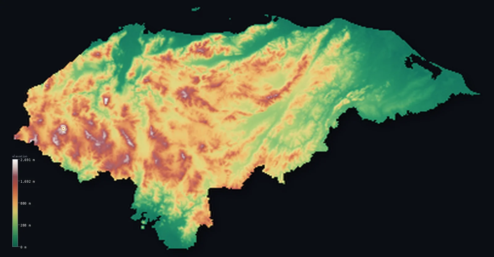
Honduras’s highest point is Cerro Las Minas (Pico Celaque) at 9,416 ft (2,870 m); its lowest is Caribbean Sea at 0 ft (0 m); the mean elevation is 2,060 ft (628 m).
Honduras is the most mountainous country in Central America — and, unusually for the region, it is high throughout, not just along a volcanic spine. Rugged interior highlands, a maze of steep ranges and high valleys, cover most of the country, so that half of Honduras lies above about 2,000 ft. These are fold mountains rather than volcanoes: alone among the Central American republics, Honduras has no active volcanoes. The highlands drop to a broad Caribbean coastal plain in the north — the Mosquito Coast reaching east into the wild, wet Mosquitia — and to a short Pacific outlet on the Gulf of Fonseca in the south. The highest point, Cerro Las Minas, reaches 9,416 ft (2,870 m).
- Highest point📚
- 9,416 ft2,870 m
- Honduras's highest point is Cerro Las Minas at 9,416 ft (2,870 m), in the Celaque massif of the rugged western highlands, near the Guatemalan border — the highest of the many fold-mountain ranges that cover the country's interior. It stands amid cloud forest, high above the surrounding valleys, in a country whose high ground is not volcanic but the folded, eroded rock of Central America's mountainous heart.
- Lowest point📚
- 0 ft0 m
- Honduras's lowest point is the Caribbean Sea at sea level, along the broad northern coastal plain — with a short Pacific outlet on the Gulf of Fonseca in the south the other sea-level low. From both coasts, but especially from the long Caribbean lowland, the land rises quickly into the mountainous interior.
- Mean elevation⚙
- 2,060 ft628 m
- Computed from the GLO-30 model, Honduras's mean elevation is 2,060 ft (628 m) — and, unusually for Central America, the median sits close to the mean: Honduras is genuinely mountainous throughout, not a low country with a few high peaks but a land of rugged highlands where the typical point is high, with the coastal plains the main low ground.
- Median elevation⚙
- 1,955 ft596 m
- Half of Honduras lies above about 1,955 ft (596 m) — a high figure, close to the mean, and the sign of a genuinely mountainous country: the interior highlands cover so much of Honduras that the typical point is high upland, with only the Caribbean coastal plain and the river valleys standing lower. It is the most consistently high country in Central America.
- Elevation range📚
- 9,416 ft2,870 m
- From the Caribbean coast to the summit of Cerro Las Minas at 2,870 m, Honduras's terrain spans about 9,416 ft — from a sea-level coast up into rugged interior highlands that make up most of the country, a land high throughout rather than crowned by a single volcanic spine.
- Above 1,000 m (3,281 ft)⚙
- 22%
- About 22% of Honduras rises above 1,000 m (3,281 ft) — much of the mountainous interior, the many highland ranges and valleys that cover the heart of the country. The Caribbean coastal plain in the north and the Pacific lowland in the south lie below.
- Official area📚
- 43,433 mi²112,492 km²
- Honduras covers about 43,400 sq mi (112,492 sq km) — the most mountainous country in Central America, high throughout, of rugged interior fold-mountain highlands between a broad Caribbean coastal plain in the north and a short Pacific outlet on the Gulf of Fonseca in the south, with no active volcanoes.
- Forest cover📚
- 40%
- About 40% of Honduras is forested — pine and cloud forest across the mountainous interior, tropical rainforest in the wet Mosquitia of the east, and mangroves and wetlands along the Caribbean coast.
Highest and lowest points
Honduras's highest point is Cerro Las Minas, 9,416 ft (2,870 m), in the Celaque massif of the rugged western highlands, near the Guatemalan border. Celaque is a great block of cloud-forested mountains rising above the surrounding country, and Las Minas is its summit — the highest point in Honduras. What is notable is what it is not: a volcano. Honduras's mountains are folded, eroded ranges — part of the ancient highland core of the isthmus rather than the volcanic arc that runs down the Pacific side of the region — and, alone among the Central American countries, Honduras has no active volcanoes at all, and has seen no eruption in thousands of years. And unlike its neighbours, Honduras is mountainous throughout: not a low country spiked by volcanoes, but a genuinely high land of ranges and valleys, of which Las Minas is simply the highest.
source ↗Honduras's lowest point is the Caribbean Sea at sea level, along a broad northern coastal plain that runs the length of the country and widens eastward into the Mosquitia — a vast, wet, thinly settled wilderness of rainforest, swamp, and lagoon, one of the largest such lowlands in Central America. The country also has a short Pacific coast in the south, on the Gulf of Fonseca. But Honduras is defined by what lies between: a rugged, mountainous interior, a tangle of steep ranges and high valleys covering most of the country. Unusually for Central America, these are fold mountains, not volcanoes — alone among the region's countries, Honduras has no active volcanoes, and has seen no eruption in thousands of years. Rivers like the Ulúa and the Patuca drain the highlands north to the Caribbean through the coastal lowlands.
source ↗Honduras at a glance
Honduras is the most mountainous country in Central America - and high throughout, its rugged interior highlands covering most of the land, with half the country above about 600 m.
source ↗Alone among the Central American countries, Honduras has no active volcanoes - its mountains are folded, eroded ranges rather than the volcanic arc that runs through its neighbours.
source ↗Honduras's highest point, Cerro Las Minas (2,870 m), rises in the cloud-forested Celaque massif of the western highlands - a fold mountain, not a volcano.
source ↗Eastern Honduras holds the Mosquitia - a vast, wet, roadless wilderness of rainforest and lagoon on the Caribbean coast, one of the largest such lowlands in Central America.
source ↗The Bay Islands off Honduras's Caribbean coast lie along the Mesoamerican Barrier Reef, the second-largest coral reef in the world.
source ↗Honduras has a long Caribbean coast but only a short Pacific outlet - a narrow frontage on the Gulf of Fonseca, shared with El Salvador and Nicaragua.
source ↗
Elevation profile of Honduras
The largest share of land, 26%, falls in the 0–200 m band, and 56% of the territory lies above 500 m (1,640 ft).
- below 500 m (1,640 ft)44%
- 500–1,000 m35%
- 1,000–2,000 m21%
- above 2,000 m (6,562 ft)1%
Highest peaks of Honduras
| Peak | Elevation | Range | Note |
|---|---|---|---|
| Cerro Las Minas (Pico Celaque)↗ | 9,416 ft2,870 m | Cordillera de Celaque (west) | Highest point of Honduras, the summit of the Celaque massif in the western interior. |
| Cerro Santa Barbara↗ | 9,003 ft2,744 m | Central highlands (near Lake Yojoa) | The second-highest peak in Honduras, above Lake Yojoa in the centre of the country. |
| Cerro El Pital↗ | 8,957 ft2,730 m | Sierra del Merendon (El Salvador border) | On the Honduras-El Salvador border; it is also the highest point of El Salvador. |
| Pico Bonito↗ | 7,989 ft2,435 m | Cordillera Nombre de Dios (Caribbean coast) | A steep coastal peak rising almost from sea level near La Ceiba on the Caribbean coast. |
| Cerro Montecristo↗ | 7,933 ft2,418 m | Sierra del Merendon (tripoint) | At the El Salvador-Guatemala-Honduras tripoint, in a shared transboundary cloud-forest reserve. |
Honduras: the mountainous interior, the Caribbean coast and the Mosquitia, and the Pacific south
The mountainous interior
Most of Honduras is rugged highland — a tangle of steep fold-mountain ranges and high valleys covering the heart of the country, high throughout, holding the capital, Tegucigalpa, and much of the population, and rising to Cerro Las Minas (the high point) in the west. Not volcanic but folded and eroded, it is the mountainous core that defines Honduras.
The Caribbean coast and the Mosquitia
Along the north runs a broad Caribbean coastal plain, widening eastward into the Mosquitia — a vast, wet, roadless wilderness of rainforest, swamp, and lagoon. The country's low, wet, tropical northern edge, drained by rivers from the highlands.
The Pacific south (the Gulf of Fonseca)
In the south, a short stretch of lowland reaches the Pacific at the Gulf of Fonseca — Honduras's only Pacific frontage, a small, hot coastal plain shared with El Salvador and Nicaragua. The country's brief southern outlet to the Pacific.
How to read this map
Color shows elevation; the raised relief shows real terrain. On this map Honduras reads as a mountainous country high throughout — a broad texture of mid-to-high browns covering most of it, the rugged interior highlands and valleys (highest at Cerro Las Minas in the west), dropping to the low green of the broad Caribbean coastal plain and the Mosquitia in the north and east, and the short Pacific lowland in the south. Unlike its neighbours, no single volcanic spine stands out — the height is spread across the whole interior.
The 3D relief is the actual GLO-30 elevation data, exaggerated vertically; the ×N relief slider controls how much. Tap anywhere to read that point's exact elevation.
City elevations in Honduras
Honduras's cities include Tegucigalpa, the capital, high in the mountainous interior, San Pedro Sula in the northern Ulúa valley toward the Caribbean, La Ceiba on the Caribbean coast, and Choluteca in the south. The capital lies high; the industrial and coastal cities lie lower.
| City | Population | Elevation |
|---|---|---|
| Tegucigalpacapitalthe capital, high in the interior highlands ↗ | 850,848 | 3,091 ft942 m |
| San Pedro Sulain the northern Ulúa valley, toward the Caribbean ↗ | 801,259 | 285 ft87 m |
| Danlíin the eastern highlands, toward Nicaragua ↗ | 233,789 | 2,493 ft760 m |
| La Ceibaon the Caribbean coast ↗ | 222,055 | 46 ft14 m |
| Catacamasin the eastern interior, toward the Mosquitia ↗ | 140,548 | 1,467 ft447 m |
| Siguatepequein the central highlands ↗ | 127,468 | 3,540 ft1,079 m |
| Tocoaon the Caribbean coastal plain in the northeast ↗ | 111,972 | 138 ft42 m |
| Ciudad Cholutecain the southern lowlands, toward the Gulf of Fonseca ↗ | 75,872 | 161 ft49 m |
| San Pedro de Copánin the western highlands, near the Guatemalan border ↗ | 63,829 | 2,710 ft826 m |
| Macuelizoin the northwest, near Guatemala ↗ | 34,401 | 856 ft261 m |
Elevation sampled at each city centre from the Copernicus GLO-30 model. Cities and population from GeoNames (CC-BY 4.0).
Honduras in comparison
Honduras's terrain rises 9,416 ft (2,870 m) from sea level to Cerro Las Minas (Pico Celaque) — about 32% of the height of Mount Everest, the world's highest point at 29,032 ft (8,849 m).
- Guatemala's mean elevation is 2,444 ft — 384 ft higher; its high point, Volcan Tajumulco, reaches 13,845 ft (4,220 m), 4,429 ft above. Guatemala elevation map →
- Nicaragua's mean elevation is 728 ft — 1,332 ft lower; its high point, Mogoton, reaches 6,913 ft (2,107 m), 2,503 ft below. Nicaragua elevation map →
- El Salvador's mean elevation is 1,184 ft — 876 ft lower; its high point, Cerro El Pital, reaches 8,957 ft (2,730 m), 459 ft below. El Salvador elevation map →
- Mexico's mean elevation is 3,415 ft — 1,355 ft higher; its high point, Pico de Orizaba (Citlaltepetl), reaches 18,491 ft (5,636 m), 9,075 ft above. Mexico elevation map →
Frequently asked questions
What is the highest point in Honduras?
- Cerro Las Minas, 9,416 ft (2,870 m), in the Celaque massif of the western highlands - a fold mountain, not a volcano, the highest of the country's rugged interior ranges.
What is the lowest point in Honduras?
- Sea level, on both coasts - the broad Caribbean coast in the north and a short Pacific outlet on the Gulf of Fonseca in the south.
What is the average elevation of Honduras?
- Computed from the Copernicus GLO-30 model, the area-weighted mean is 2,060 ft (628 m) - and unusually for Central America the median is close to it, because Honduras is genuinely mountainous throughout, not a low country with a few high peaks.
Does Honduras have volcanoes?
- No active ones - alone among the Central American countries, Honduras has no active volcanoes and has seen no eruption in thousands of years. Its mountains are folded, eroded ranges, not the volcanic arc of its neighbours.
Is Honduras mountainous?
- Yes - the most mountainous country in Central America, high throughout, its rugged interior highlands covering most of the land. Half the country lies above about 600 m.
Is this a topographic, relief, contour, or elevation map of Honduras?
- They describe the same thing - terrain height. This page renders the country's actual elevation surface in interactive 3D and reports the statistics computed from it.
About this map
The terrain is rendered from the Copernicus GLO-30 digital elevation model (ESA), masked to the HND-ADM0 boundary from geoBoundaries (gbOpen). Elevation statistics are computed directly from the model; peak names and researched facts are sourced and cited. See the methodology for the full pipeline.
Our area-weighted mean, computed from the Copernicus GLO-30 model, is 2,060 ft (628 m); the figure commonly cited elsewhere is 2,244 ft (684 m) (CIA World Factbook). About four-fifths of Honduras is mountainous interior, with lowlands only on the broad Caribbean coast and the narrow Pacific strip, giving a fairly high mean elevation; the page reports the area-weighted figure computed from the Copernicus GLO-30 model.
Surveyed national figures: official area · forest cover · high point.
Rendered from Copernicus GLO-30 (ESA, 2021 release), boundaries from geoBoundaries. Generated 2026-06-23.
Bordering countries · 3
Honduras shares a land border with these countries — open any one to compare its terrain and highest point.