Nicaragua Elevation Map — Topographic & 3D Terrain
Explore the terrain of Nicaragua in interactive 3D, built from Copernicus GLO-30 satellite elevation data — a low country of great lakes and Pacific volcanoes, with a vast Caribbean lowland. Drag to rotate, scroll to zoom, and tap any point to read its elevation.
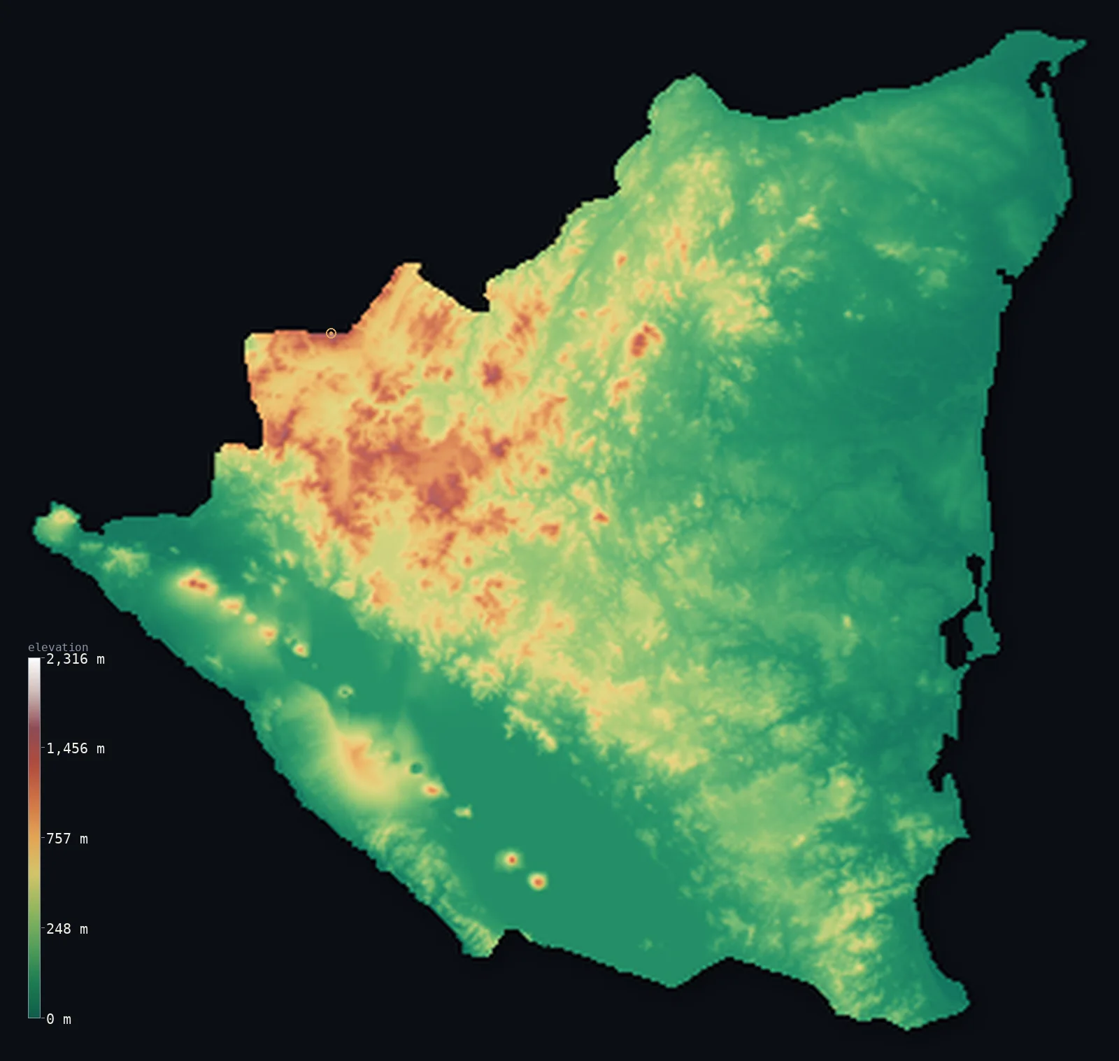
Nicaragua’s highest point is Mogoton at 6,913 ft (2,107 m); its lowest is Pacific Ocean at 0 ft (0 m); the mean elevation is 728 ft (222 m).
Nicaragua is the largest country in Central America, and one of the lowest-lying. Most of it is lowland — a vast, wet Caribbean plain, the Mosquito Coast, spreading across the whole eastern half of the country, and a lowland trough in the west holding the two great lakes, Lake Nicaragua and Lake Managua. Along the Pacific, a chain of volcanoes rises from the lowlands — the Maribios range, with cones like Momotombo above the lakes. The higher ground is in the north-centre, cooler highlands rising toward the Honduran border and the country's highest point, Mogotón, at 6,913 ft (2,107 m). Half of Nicaragua lies below about 350 ft — a low country, with volcanoes and highlands rising from broad plains.
- Highest point📚
- 6,913 ft2,107 m
- Nicaragua's highest point is Mogotón at 6,913 ft (2,107 m), in the northern highlands on the border with Honduras — the highest of the cooler central-northern uplands that rise toward Honduras, well above the lowlands and volcanoes that make up most of the country. Its summit sits right on the frontier; the highest ground within Nicaragua itself reaches a little lower.
- Lowest point📚
- 0 ft0 m
- Nicaragua's lowest point is the sea at sea level, on both coasts — the vast Caribbean lowland of the Mosquito Coast in the east, and the Pacific in the west. Much of the country lies only a little above the sea: the great lakes in the western trough sit low, and the eastern half is a broad, low coastal plain.
- Mean elevation⚙
- 728 ft222 m
- Computed from the GLO-30 model, Nicaragua's mean elevation is 728 ft (222 m) — a low figure, and the lowest mean in Central America, reflecting a country that is mostly lowland: the vast Caribbean plain in the east and the lake-filled trough in the west lie low, with the Pacific volcanoes and the northern highlands the higher ground rising from them.
- Median elevation⚙
- 351 ft107 m
- Half of Nicaragua lies below about 351 ft (107 m) — a low figure, lower even than the mean, because the huge Caribbean lowland and the western lake basins cover so much of the country: the typical point is low plain, with only the volcanoes and the northern highlands rising well above.
- Elevation range📚
- 6,913 ft2,107 m
- From the sea to the summit of Mogotón at 2,107 m, Nicaragua's terrain spans about 6,913 ft — but most of the country is low: the rise is held in the Pacific volcanoes and, higher still, the northern highlands on the Honduran border, above a broad lowland majority.
- Above 1,000 m (3,281 ft)⚙
- 2%
- About 2% of Nicaragua rises above 1,000 m (3,281 ft) — just the higher volcanic cones and the northern highlands rising toward Honduras; even 500 m (1,640 ft) is cleared by only 14% of the country. The vast Caribbean lowland in the east and the lake trough in the west lie well below.
- Official area📚
- 50,337 mi²130,373 km²
- Nicaragua covers about 50,300 sq mi (130,373 sq km) — the largest Central American country, and one of the lowest, of a vast Caribbean lowland (the Mosquito Coast) in the east, a western trough holding Lakes Nicaragua and Managua, a chain of Pacific volcanoes, and cooler highlands in the north rising to Mogotón.
- Forest cover📚
- 25.3%
- About 25% of Nicaragua is forested — vast tropical rainforest across the wet Caribbean lowlands of the east (among the largest in Central America), with pine and cloud forest in the northern highlands and drier woodland on the Pacific side.
Highest and lowest points
Nicaragua's highest point is Mogotón, 6,913 ft (2,107 m), in the northern highlands on the border with Honduras. It stands in the cooler, forested uplands of north-central Nicaragua — the Cordillera Isabelia and the ranges toward Honduras — which are the highest ground in the country, well above the lowlands and the volcanoes that define most of it. Mogotón's summit lies right on the Honduran frontier: it is Nicaragua's highest point, though not Honduras's, which rises higher still to the west. (The peak itself sits on the border, so the highest ground fully within Nicaragua is a little lower than the summit figure.) Notably, Nicaragua's high point is not one of its famous volcanoes — those, like Momotombo and San Cristóbal along the Pacific, are lower, rising from the lake trough — but the quieter northern highlands, the eroded uplands shared with Honduras.
source ↗Nicaragua's lowest point is the sea at sea level, and much of the country lies close to it. The whole eastern half is the Mosquito Coast — a vast, wet, thinly peopled Caribbean lowland of rainforest, savanna, swamp, and lagoon, one of the largest such wildernesses in Central America. In the west, a broad structural lowland — the Nicaraguan Depression — holds the two great lakes, Lake Nicaragua (the largest lake in Central America) and Lake Managua, sitting low between the Pacific and the interior. Along the Pacific edge of this trough rises a chain of volcanoes, the Maribios, their cones standing dramatically above the lakes and plains. Only in the north-centre does the land rise into cooler, higher highlands, toward the Honduran border. So Nicaragua is mostly low — lowland east and west — with volcanoes and northern highlands rising from the plains.
source ↗Mogoton is a border summit: its peak lies about 1 km outside the generalized Nicaragua boundary, so the highest fully in-territory land pixel in the model is 6,129 ft (1,868 m). The headline figure above is the surveyed elevation of the recognised national high point.
Nicaragua at a glance
Lake Nicaragua is the largest lake in Central America - a vast freshwater lake in the western lowland trough, dotted with islands and even its own freshwater sharks.
source ↗Nicaragua is the largest Central American country and one of the lowest - half of it lies below about 100 m, with a vast Caribbean lowland and a lake-filled western trough.
source ↗A chain of Pacific volcanoes, the Maribios, rises from Nicaragua's western lowlands - including Momotombo, above Lake Managua, and the island volcanoes of Lake Nicaragua.
source ↗Eastern Nicaragua is the Mosquito Coast - a vast, wet, thinly settled Caribbean lowland of rainforest and lagoon, one of the largest wildernesses in Central America.
source ↗Nicaragua's highest point, Mogotón (2,107 m), is not a volcano but a peak in the northern highlands on the Honduran border.
source ↗Ometepe, an island in Lake Nicaragua formed by two volcanoes, rises straight from the lake - one of the most striking landscapes in Central America.
source ↗
Elevation profile of Nicaragua
The largest share of land, 65%, falls in the 0–200 m band, and 86% of the territory lies below 500 m (1,640 ft).
- below 500 m (1,640 ft)86%
- 500–1,000 m12%
- 1,000–2,000 m2%
Highest peaks of Nicaragua
| Peak | Elevation | Range | Note |
|---|---|---|---|
| Mogoton↗ | 6,913 ft2,107 m | Cordillera de Dipilto (north, Honduras border) | Highest point of Nicaragua, a border summit in the northern highlands. |
| San Cristobal (Volcan)↗ | 5,725 ft1,745 m | Cordillera Los Maribios (northwest) | Nicaragua's highest and most prominent volcano, an active cone near the Gulf of Fonseca. |
| Concepcion (Volcan)↗ | 5,282 ft1,610 m | Ometepe Island (Lake Nicaragua) | An active stratovolcano forming the larger half of Ometepe Island in Lake Nicaragua. |
| Mombacho (Volcan)↗ | 4,409 ft1,344 m | Cordillera Los Maribios (near Granada) | A cloud-forested volcano rising above Granada and Lake Nicaragua. |
| Momotombo (Volcan)↗ | 4,255 ft1,297 m | Cordillera Los Maribios (Lake Managua) | A landmark cone rising dramatically from the shore of Lake Managua. |
Nicaragua: the Caribbean lowlands, the western lakes and volcanoes, and the northern highlands
The Caribbean lowlands (the Mosquito Coast)
The whole eastern half of Nicaragua is low Caribbean plain — the Mosquito Coast, a vast, wet wilderness of rainforest, savanna, swamp, and lagoon, thinly peopled and drained by rivers from the interior. Broad, low, and green, it is the largest part of the country's area.
The western lakes and volcanoes
In the west, a structural lowland trough — the Nicaraguan Depression — holds the great lakes, Nicaragua and Managua, with a chain of Pacific volcanoes (the Maribios, Momotombo) rising along its edge. Low, lake-filled, and volcanic, it holds most of the population.
The northern highlands
In the north-centre the land rises into cooler, forested highlands — the Cordillera Isabelia and ranges toward Honduras, holding Mogotón (the high point). The country's highest, coolest ground, well above the lowlands.
How to read this map
Color shows elevation; the raised relief shows real terrain. On this map Nicaragua reads as a low country with volcanoes and northern highlands rising from it — the broad low green of the Caribbean Mosquito Coast filling the east, the dark sheets of Lakes Nicaragua and Managua in the low western trough, the volcanic cones of the Maribios standing sharply along the Pacific, and the higher browns of the northern highlands toward Honduras (highest at Mogotón).
The 3D relief is the actual GLO-30 elevation data, exaggerated vertically so the low plains, the volcanoes, and the highlands all show; the ×N relief slider controls how much. Tap anywhere to read that point's exact elevation.
City elevations in Nicaragua
Nicaragua's cities cluster in the western lake-and-volcano lowland and the northern highlands — Managua, the capital, on the shore of Lake Managua, León toward the Pacific volcanoes, Estelí and Matagalpa in the northern highlands, and Bluefields and Puerto Cabezas on the thinly-settled Caribbean coast. Most of the largest lie low, in the west.
| City | Population | Elevation |
|---|---|---|
| Managuacapitalthe capital, on the shore of Lake Managua ↗ | 973,087 | 348 ft106 m |
| Leónin the west, below the Maribios volcanoes ↗ | 144,538 | 335 ft102 m |
| Matagalpain the north-central highlands ↗ | 109,089 | 2,238 ft682 m |
| Estelíin the northern highlands ↗ | 96,422 | 2,759 ft841 m |
| Nueva Guineain the southeastern interior, toward the Caribbean lowlands ↗ | 52,929 | 679 ft207 m |
| Juigalpain the centre, east of Lake Nicaragua ↗ | 50,000 | 387 ft118 m |
| Bluefieldson the Caribbean coast ↗ | 44,373 | 59 ft18 m |
| Ocotalin the far north, near Mogotón and the Honduran border ↗ | 33,928 | 2,005 ft611 m |
| Puerto Cabezason the Caribbean Mosquito Coast in the northeast ↗ | 33,635 | 36 ft11 m |
| Rivason the isthmus between Lake Nicaragua and the Pacific ↗ | 30,000 | 203 ft62 m |
Elevation sampled at each city centre from the Copernicus GLO-30 model. Cities and population from GeoNames (CC-BY 4.0).
Nicaragua in comparison
Nicaragua's terrain rises 6,913 ft (2,107 m) from sea level to Mogoton — about 24% of the height of Mount Everest, the world's highest point at 29,032 ft (8,849 m).
- Honduras's mean elevation is 2,060 ft — 1,332 ft higher; its high point, Cerro Las Minas (Pico Celaque), reaches 9,416 ft (2,870 m), 2,503 ft above. Honduras elevation map →
- Costa Rica's mean elevation is 1,844 ft — 1,115 ft higher; its high point, Cerro Chirripó, reaches 12,536 ft (3,821 m), 5,623 ft above. Costa Rica elevation map →
- El Salvador's mean elevation is 1,184 ft — 456 ft higher; its high point, Cerro El Pital, reaches 8,957 ft (2,730 m), 2,044 ft above. El Salvador elevation map →
- Guatemala's mean elevation is 2,444 ft — 1,716 ft higher; its high point, Volcan Tajumulco, reaches 13,845 ft (4,220 m), 6,932 ft above. Guatemala elevation map →
Frequently asked questions
What is the highest point in Nicaragua?
- Mogotón, 6,913 ft (2,107 m), in the northern highlands on the Honduran border - a peak, not a volcano; its summit sits on the frontier, with Nicaragua's highest ground reaching a little lower.
What is the lowest point in Nicaragua?
- Sea level, on both coasts - the vast Caribbean Mosquito Coast in the east and the Pacific in the west; much of the country lies only a little above the sea.
What is the average elevation of Nicaragua?
- Computed from the Copernicus GLO-30 model, the area-weighted mean is 728 ft (222 m) - the lowest in Central America, because Nicaragua is mostly lowland, with volcanoes and northern highlands rising from broad plains.
What is the largest lake in Central America?
- Lake Nicaragua, in Nicaragua's western lowland trough - a vast freshwater lake with islands, volcanoes, and even freshwater sharks.
Is Nicaragua flat?
- Mostly low, not entirely flat - a vast low Caribbean plain and a lake-filled western trough make up much of it, but Pacific volcanoes and northern highlands (rising to Mogotón, 2,107 m) stand above the lowlands. Half the country lies below about 100 m.
Is this a topographic, relief, contour, or elevation map of Nicaragua?
- They describe the same thing - terrain height. This page renders the country's actual elevation surface in interactive 3D and reports the statistics computed from it.
About this map
The terrain is rendered from the Copernicus GLO-30 digital elevation model (ESA), masked to the NIC-ADM0 boundary from geoBoundaries (gbOpen). Elevation statistics are computed directly from the model; peak names and researched facts are sourced and cited. See the methodology for the full pipeline.
Our area-weighted mean, computed from the Copernicus GLO-30 model, is 728 ft (222 m); the figure commonly cited elsewhere is 978 ft (298 m) (CIA World Factbook). Nicaragua has the lowest mean elevation in Central America — a vast Caribbean lowland in the east and the lake-filled western trough cover most of the country, with the Pacific volcanoes and the northern highlands its only substantial high ground. The computed figure runs below the mean sometimes cited elsewhere because so much of Nicaragua is low: half the country lies below about 351 ft (107 m).
Surveyed national figures: official area · forest cover · high point.
Rendered from Copernicus GLO-30 (ESA, 2021 release), boundaries from geoBoundaries. Generated 2026-06-25.
Bordering countries · 2
Nicaragua shares a land border with these countries — open any one to compare its terrain and highest point.