Costa Rica Elevation Map — Topographic & 3D Terrain
Explore the terrain of Costa Rica in interactive 3D, built from Copernicus GLO-30 satellite elevation data — a volcanic cordillera and the high Talamanca between two coasts. Drag to rotate, scroll to zoom, and tap any point to read its elevation.
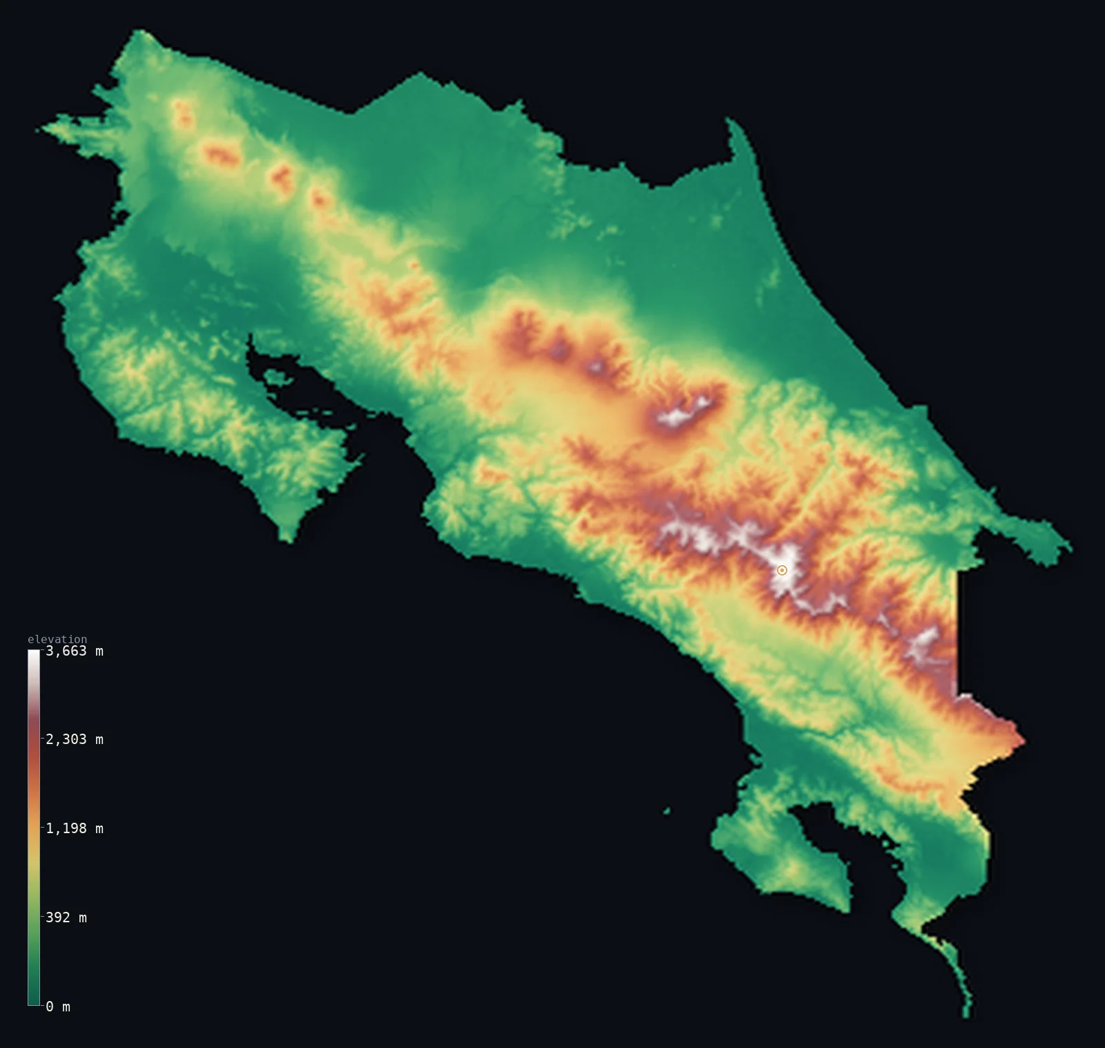
Costa Rica’s highest point is Cerro Chirripó at 12,536 ft (3,821 m); its lowest is Pacific Ocean / Caribbean Sea at 0 ft (0 m); the mean elevation is 1,844 ft (562 m).
Costa Rica is a mountainous country between the Pacific and the Caribbean, its spine a chain of highlands running the length of the isthmus. Volcanic ranges cross the north and centre — the Cordillera Central, with the active volcanoes Poás, Irazú, and Arenal, ringing the high Central Valley where most Costa Ricans live — while in the south rises the Cordillera de Talamanca, a high, non-volcanic massif holding the country's highest point, Cerro Chirripó, at 12,536 ft (3,821 m), the second-highest peak in Central America. But the mountains are a central band: broad lowlands fall away to both coasts — the Caribbean plain in the east, the Pacific with its peninsulas and gulfs in the west — so about half the country lies below about 840 ft.
- Highest point📚
- 12,536 ft3,821 m
- Costa Rica's highest point is Cerro Chirripó at 12,536 ft (3,821 m), in the Cordillera de Talamanca of the south — the second-highest peak in Central America, after Guatemala's Tajumulco. Unlike the active volcanoes of the country's central ranges, Chirripó is a non-volcanic summit, the high point of the great Talamanca massif, rising to a bare, cold, glacially-sculpted top high above the surrounding cloud forest.
- Lowest point📚
- 0 ft0 m
- Costa Rica's lowest point is the sea at sea level, on both coasts — the Caribbean in the east and the Pacific in the west, the latter deeply indented with peninsulas and gulfs (Nicoya, Osa). From both shores the land rises toward the mountainous interior.
- Mean elevation⚙
- 1,844 ft562 m
- Computed from the GLO-30 model, Costa Rica's mean elevation is 1,844 ft (562 m) — but its height is concentrated in a central mountain band: the volcanic cordilleras and the high Talamanca hold most of the relief and the people, while the broad coastal lowlands on both seas keep the typical point far lower, at a median of 840 ft (256 m).
- Median elevation⚙
- 840 ft256 m
- Half of Costa Rica lies below about 840 ft (256 m) — below the mean, because the country's mountains, though high, are a central band: the Caribbean and Pacific lowlands make up much of the area, while the volcanic ranges and the Talamanca are the high minority that lifts the average.
- Elevation range📚
- 12,536 ft3,821 m
- From either coast to the summit of Cerro Chirripó at 3,821 m, Costa Rica's terrain climbs about 12,536 ft — from tropical sea-level coasts to the second-highest peak in Central America, across a country of high volcanic ranges and the Talamanca massif rising between two low coastal plains.
- Above 1,000 m (3,281 ft)⚙
- 21%
- About 21% of Costa Rica rises above 1,000 m (3,281 ft) — the volcanic Cordillera Central and its Central Valley, and the high Cordillera de Talamanca in the south. The Caribbean and Pacific coastal lowlands lie below.
- Above 2,000 m (6,562 ft)⚙
- 6%
- Roughly 6% of Costa Rica stands above 2,000 m (6,562 ft) — the higher volcanic peaks and, above all, the high Talamanca massif around Cerro Chirripó, the country's highest ground.
- Official area📚
- 19,730 mi²51,100 km²
- Costa Rica covers about 19,700 sq mi (51,100 sq km) — a mountainous Central American country between the Caribbean and the Pacific, of volcanic cordilleras (the active Poás, Irazú, Arenal) ringing the high Central Valley, and the high non-volcanic Talamanca massif (holding Cerro Chirripó, Central America's second-highest peak) in the south, between two coastal lowlands.
- Forest cover📚
- 53.5%
- About 54% of Costa Rica is forested — famously green, with tropical rainforest on both coasts, cloud forest on the high mountain slopes (Monteverde), and much of the country under protection in an extensive national-park system.
Highest and lowest points
Costa Rica's highest point is Cerro Chirripó, 12,536 ft (3,821 m), in the Cordillera de Talamanca of southern Costa Rica — the second-highest peak in all of Central America, after Guatemala's Tajumulco. Unlike the volcanoes that make Costa Rica famous, Chirripó is not volcanic: it is the high point of the Talamanca, a massive block of ancient uplifted rock, its summit bare, cold, and marked by the lakes and scoured rock of past glaciation — from the top, on a clear day, one can see both the Caribbean and the Pacific. The volcanic ranges to the north — the Cordillera Central, with the active Poás, Irazú, and Arenal — are lower, ringing the Central Valley. So Costa Rica's highest ground is not one of its volcanoes but the great Talamanca massif, and Chirripó is its crown.
source ↗Costa Rica's lowest point is the sea at sea level, on both of its coasts — the Caribbean in the east, a straight, wet lowland shore, and the Pacific in the west, a coast deeply cut by the Gulfs of Nicoya and Dulce and the Nicoya and Osa peninsulas. Between the two seas rises the mountainous backbone of the country: in the north and centre, volcanic ranges — the Cordillera de Guanacaste, Tilarán, and Central — including the active volcanoes Arenal, Poás, and Irazú, ringing the high Central Valley (the Valle Central) where the capital, San José, and most of the population sit. In the south rises the higher, non-volcanic Cordillera de Talamanca, the greatest massif in the country. From this central spine the land falls to the coastal lowlands on either side.
source ↗Costa Rica at a glance
Costa Rica's highest point, Cerro Chirripó (3,821 m), is the second-highest peak in Central America - and, unlike the country's famous volcanoes, it is a non-volcanic summit in the Talamanca massif.
source ↗Costa Rica's Cordillera Central holds active volcanoes - Poás, Irazú, and Arenal - ringing the high Central Valley where most of the population lives.
source ↗From the summit of Cerro Chirripó, on a clear day, both the Caribbean Sea and the Pacific Ocean can be seen.
source ↗Costa Rica is mostly lower than its mountains suggest - about half the country lies below about 250 m, with the high cordilleras a central band between broad coastal lowlands.
source ↗Costa Rica protects a remarkable share of its land in national parks and reserves - among the most extensive protected-area systems in the world for its size.
source ↗The high Talamanca massif shows signs of past glaciation - lakes and scoured rock near Chirripó's summit, rare evidence of ice age glaciers so near the equator.
source ↗
Elevation profile of Costa Rica
The largest share of land, 50%, falls in the 0–250 m band, and 63% of the territory lies below 500 m (1,640 ft).
- below 500 m (1,640 ft)63%
- 500–1,000 m16%
- 1,000–2,000 m16%
- above 2,000 m (6,562 ft)6%
Highest peaks of Costa Rica
| Peak | Elevation | Range | Note |
|---|---|---|---|
| Cerro Chirripó↗ | 12,536 ft3,821 m | Cordillera de Talamanca | Highest point of Costa Rica and second-highest in Central America, in the non-volcanic Talamanca range. |
| Cerro Ventisqueros↗ | 12,507 ft3,812 m | Cordillera de Talamanca | The second-highest peak in Costa Rica, close to Chirripó, named for its cold 'glacial winds'. |
| Irazú Volcano↗ | 11,260 ft3,432 m | Cordillera Volcánica Central | The highest volcano in Costa Rica, an active stratovolcano overlooking the Central Valley near San José. |
| Turrialba Volcano↗ | 10,958 ft3,340 m | Cordillera Volcánica Central | An active volcano of the central cordillera with persistent fumarolic activity, near Irazú. |
| Poás Volcano↗ | 8,885 ft2,708 m | Cordillera Volcánica Central | An active volcano with one of the world's largest acidic crater lakes, on the northern rim of the Central Valley. |
Costa Rica: the volcanic cordilleras and the Central Valley, the high Talamanca, and the coastal lowlands
The volcanic cordilleras and the Central Valley
Across the north and centre run volcanic ranges — the Cordilleras de Guanacaste, Tilarán, and Central, with active volcanoes (Arenal, Poás, Irazú) — ringing the high Central Valley, the fertile volcanic basin where the capital and most Costa Ricans live. The country's volcanic, populous heart.
The Cordillera de Talamanca
In the south rises the Cordillera de Talamanca — a high, rugged, non-volcanic massif, the greatest in the country, holding Cerro Chirripó (the high point and Central America's second-highest peak) and remnants of past glaciation, and continuing east across the border into western Panama. The highest, wildest ground in Costa Rica.
The coastal lowlands
Broad lowlands fall to both seas — the Caribbean plain in the east, wet and straight, and the Pacific coast in the west, deeply cut by the Nicoya and Osa peninsulas and their gulfs. The low, tropical margins on either side of the mountains.
How to read this map
Color shows elevation; the raised relief shows real terrain. On this map Costa Rica reads as a mountainous central spine between two low coasts — the browns of the volcanic Cordillera Central (its cones ringing the Central Valley) across the centre-north, rising to the high Talamanca massif in the south (highest at Cerro Chirripó), and dropping to the low green of the Caribbean plain in the east and the peninsula-cut Pacific coast in the west.
The 3D relief is the actual GLO-30 elevation data, exaggerated vertically so the high ranges and the low coasts both show; the ×N relief slider controls how much. Tap anywhere to read that point's exact elevation. (Cocos Island, far offshore in the Pacific, is mapped separately and not shown here.)
City elevations in Costa Rica
Costa Rica's cities cluster in and around the high Central Valley — San José, the capital, in the high volcanic basin, with Turrialba on its eastern edge — and lower towns spread to the coasts: Limón on the Caribbean, Puntarenas and Liberia toward the Pacific, and San Isidro in the southern valleys below the Talamanca. Most of the population lies high, in the valley.
| City | Population | Elevation |
|---|---|---|
| San Josécapitalthe capital, in the high Central Valley ↗ | 335,007 | 3,766 ft1,148 m |
| Limónon the Caribbean coast ↗ | 63,081 | 85 ft26 m |
| Liberiain the northwest (Guanacaste), toward the Pacific ↗ | 45,380 | 482 ft147 m |
| Puntarenason the central Pacific coast ↗ | 35,650 | 16 ft5 m |
| San Isidroin the southern General valley, below the Talamanca ↗ | 34,877 | 2,343 ft714 m |
| Turrialbaon the eastern edge of the Central Valley ↗ | 28,955 | 2,110 ft643 m |
| Quesadain the northern lowlands (San Carlos) ↗ | 27,310 | 2,077 ft633 m |
| Cañasin the northwestern Guanacaste lowlands ↗ | 20,306 | 279 ft85 m |
| Guápileson the Caribbean lowland slope ↗ | 19,092 | 823 ft251 m |
| Nicoyaon the Nicoya Peninsula, on the Pacific ↗ | 15,313 | 400 ft122 m |
Elevation sampled at each city centre from the Copernicus GLO-30 model. Cities and population from GeoNames (CC-BY 4.0).
Costa Rica in comparison
Costa Rica's terrain rises 12,536 ft (3,821 m) from sea level to Cerro Chirripó — about 43% of the height of Mount Everest, the world's highest point at 29,032 ft (8,849 m).
- Panama's mean elevation is 1,017 ft — 827 ft lower; its high point, Volcan Baru, reaches 11,401 ft (3,475 m), 1,135 ft below. Panama elevation map →
- Nicaragua's mean elevation is 728 ft — 1,115 ft lower; its high point, Mogoton, reaches 6,913 ft (2,107 m), 5,623 ft below. Nicaragua elevation map →
- Guatemala's mean elevation is 2,444 ft — 600 ft higher; its high point, Volcan Tajumulco, reaches 13,845 ft (4,220 m), 1,309 ft above. Guatemala elevation map →
- Mexico's mean elevation is 3,415 ft — 1,572 ft higher; its high point, Pico de Orizaba (Citlaltepetl), reaches 18,491 ft (5,636 m), 5,955 ft above. Mexico elevation map →
Frequently asked questions
What is the highest point in Costa Rica?
- Cerro Chirripó, 12,536 ft (3,821 m), in the Cordillera de Talamanca - the second-highest peak in Central America, and, unlike the country's famous volcanoes, a non-volcanic summit.
What is the lowest point in Costa Rica?
- Sea level, on both coasts - the Caribbean in the east and the Pacific (deeply cut by peninsulas and gulfs) in the west.
What is the average elevation of Costa Rica?
- Computed from the Copernicus GLO-30 model, the area-weighted mean is 1,844 ft (562 m) - lifted by the high central mountains; about half the country lies below about 840 ft (256 m), as the coastal lowlands are low and the cordilleras are the high minority.
Does Costa Rica have volcanoes?
- Yes - active ones, in the Cordillera Central (Poás, Irazú, Arenal), ringing the high Central Valley. But the country's highest point, Cerro Chirripó, is not a volcano - it is in the non-volcanic Talamanca massif to the south.
What is the second-highest mountain in Central America?
- Cerro Chirripó in Costa Rica, at 12,536 ft (3,821 m) - in the Talamanca massif, after Guatemala's Tajumulco (4,220 m).
Is this a topographic, relief, contour, or elevation map of Costa Rica?
- They describe the same thing - terrain height. This page renders the country's actual elevation surface in interactive 3D and reports the statistics computed from it.
About this map
The terrain is rendered from the Copernicus GLO-30 digital elevation model (ESA), masked to the CRI-ADM0 boundary from geoBoundaries (gbOpen). Elevation statistics are computed directly from the model; peak names and researched facts are sourced and cited. See the methodology for the full pipeline.
Our area-weighted mean, computed from the Copernicus GLO-30 model, is 1,844 ft (562 m); the figure commonly cited elsewhere is 2,448 ft (746 m) (CIA World Factbook). Costa Rica's mountains — the volcanic cordilleras and the high Talamanca — are a central band between two low coastal lowlands, so the country is lower than its peaks suggest: half of it lies below about 840 ft (256 m). The area-weighted mean computed here from GLO-30 runs well below the figure commonly cited, because the broad Caribbean and Pacific lowlands pull the average down.
Surveyed national figures: official area · forest cover · high point.
Rendered from Copernicus GLO-30 (ESA, 2021 release), boundaries from geoBoundaries. Generated 2026-06-22.
Bordering countries · 2
Costa Rica shares a land border with these countries — open any one to compare its terrain and highest point.