North America Elevation Map
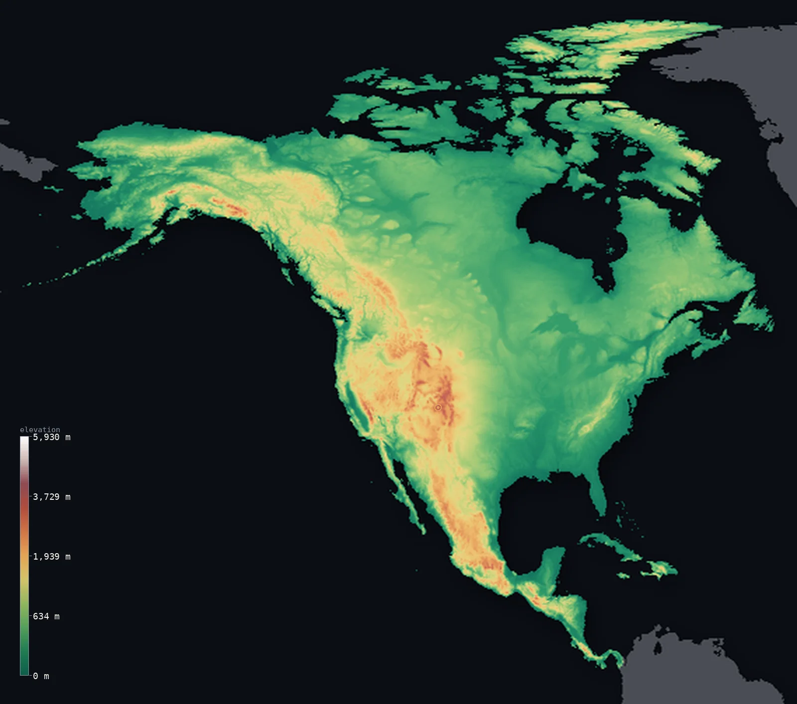
North America’s highest point is Denali at 20,308 ft (6,190 m); its lowest is Badwater Basin, Death Valley at −282 ft (−86 m); the mean elevation is 2,064 ft (629 m).
- Highest point📚
- 20,308 ft6,190 m
- North America's highest point is Denali at 20,308 ft (6,190 m), in the Alaska Range - the highest peak in North America, standing far above the surrounding Alaskan lowlands (by the rise from its base, one of the most dramatic mountains on Earth). It is the great summit of the Western Cordillera, the mountain system that runs the whole length of the continent's western side, from Alaska through the Rocky Mountains to Mexico.
- Lowest point📚
- −282 ft−86 m
- North America's lowest point is Badwater Basin in Death Valley, California, at about 282 ft (86 m) below sea level - the lowest, hottest, driest place in North America, a salt flat in the rain shadow of the Sierra Nevada. From this deep desert basin the land rises east across the deserts and the Great Plains, and west over the Sierra to the Pacific.
- Mean elevation⚙
- 2,064 ft629 m
- Computed from the GLO-30 model, North America's mean elevation is 2,064 ft (629 m) - lifted by the great Western Cordillera, the mountain system down the continent's western side. But the typical point is lower: half of North America lies below about 1,283 ft (391 m). The Great Plains, the Canadian Shield, the eastern lowlands and the Appalachians make up the broad, lower body of the continent; the high mountains are the western minority that lifts the average above it.
- Median elevation⚙
- 1,283 ft391 m
- Half of North America lies below about 1,283 ft (391 m) - well below the mean, because the continent's height is concentrated in the west. The Western Cordillera - the Rockies, the Sierra, the ranges of Alaska and Mexico - is high, but it is a minority of the area; the vast Great Plains, the low Canadian Shield, and the eastern lowlands are the broad low body of the continent, setting the typical point beneath the mountain-lifted average.
- Elevation range📚
- 20,591 ft6,276 m
- From Badwater Basin at 86 m below sea level to the summit of Denali at 6,190 m, North America spans about 20,591 ft - from the lowest desert basin on the continent up to the high, glaciated crown of the Alaska Range.
- Above 1,000 m (3,281 ft)⚙
- 22%
- About 22% of North America rises above 1,000 m (3,281 ft) - chiefly the Western Cordillera: the Rocky Mountains, the high plateaus and basins of the west, the Sierra ranges, and the mountains of Alaska and Mexico. The Great Plains rise gradually toward them, but the eastern and northern lowlands lie well below.
- Above 2,000 m (6,562 ft)⚙
- 5%
- Roughly 5% of North America stands above 2,000 m (6,562 ft) - the high country of the west: the Rocky Mountains, the Colorado Plateau and the Great Basin, the Sierra Nevada and the Mexican highlands, and the high ranges of Alaska. The elevated western spine of the continent.
- Official area📚
- 9,540,580 mi²24,710,000 km²
- North America is the third-largest continent, covering about 9,540,580 sq mi (24,710,000 sq km) - from the Arctic islands of Canada to the tropics of Central America, and from the Atlantic in the east to the Pacific in the west. Its western side is the great Western Cordillera (the Rockies, the Sierra, the Alaska ranges, holding Denali); its center and east are the vast Great Plains, the low Canadian Shield, the eastern lowlands, and the old Appalachian mountains, dropping to Death Valley, the lowest point.
- Forest cover📚
- 35%
- About 35% of North America is forested - from the vast boreal forest of Canada and Alaska (one of the largest on Earth), through the temperate forests of the east and the Pacific coast, to the tropical forests of Central America, with great grasslands on the Great Plains and deserts in the southwest and the Mexican north.
North America at a glance
Denali's rise from base to summit is among the largest of any mountain on land, thanks to its low-lying surroundings.
source ↗Death Valley's Badwater Basin, the continent's lowest point, sits only about 135 km from Mount Whitney, the highest in the contiguous US.
source ↗The ten highest peaks in the United States are all in Alaska, in the continent's northwestern corner.
source ↗The Canadian Shield around Hudson Bay is some of the oldest exposed rock on Earth.
source ↗Central America is a narrow volcanic land bridge that only fully connected the two Americas a few million years ago.
source ↗
Elevation profile of North America
The largest share of land, 59%, falls in the 0–500 m band, and 59% of the territory lies below 500 m (1,640 ft).
- below 500 m (1,640 ft)59%
- 500–1,000 m18%
- 1,000–2,000 m17%
- above 2,000 m (6,562 ft)5%
Highest and lowest points
The highest point of North America, Denali, 6,190 m, the crown of the Alaska Range in interior Alaska. Because of Earth's shape and its high-latitude base, its rise from foot to summit is among the greatest of any mountain on land.
source ↗Highest peaks of North America
| Peak | Elevation | Range | Note |
|---|---|---|---|
| Denali↗ | 20,308 ft6,190 m | Alaska Range | Highest point of North America, in interior Alaska. |
| Mount Logan↗ | 19,551 ft5,959 m | Saint Elias Mountains (Canada) | The second-highest peak in North America, in the Yukon. |
| Pico de Orizaba↗ | 18,491 ft5,636 m | Trans-Mexican Volcanic Belt | The highest peak of Mexico and the highest volcano in North America. |
| Mount Saint Elias↗ | 18,009 ft5,489 m | Saint Elias Mountains | A great peak on the Alaska-Yukon border. |
| Mount Whitney↗ | 14,505 ft4,421 m | Sierra Nevada | The highest point in the contiguous United States. |
Terrain regions of North America
Denali's rise from base to summit is among the largest of any mountain on land, thanks to its low-lying surroundings. ↗
The western Cordillera
↗The broad belt of western mountains - the Rockies, the Sierra and Cascade ranges, the Alaska Range and the Mexican sierras - holding all the continent's highest ground.
The Great Plains and interior
↗The vast central lowlands - the Canadian Shield, the Great Plains and the Mississippi basin - between the western mountains and the eastern uplands.
The eastern uplands and the south
↗The ancient, worn Appalachians and eastern coastal plains, and the isthmus of Central America narrowing toward South America.
The western Cordillera
the westAll of North America's high ground lies in the west, in a wide belt of mountains running from Alaska to Mexico. It includes the Rocky Mountains, the Sierra Nevada and Cascades, the coastal ranges, and in the far northwest the Alaska Range, whose Denali (6,190 m) is the continent's summit. In the south the belt continues as the Mexican sierras and the volcanoes of the Trans-Mexican Volcanic Belt, crowned by Pico de Orizaba. Between the ranges lie high deserts and plateaus, including Death Valley, the lowest point on the continent.
The interior plains and shield
the centreEast of the mountains spreads the great interior lowland. In the north the Canadian Shield, an expanse of ancient rock, lakes and boreal forest, wraps around Hudson Bay. Southward stretch the Great Plains, rising gently toward the Rockies, and the broad Mississippi-Missouri basin that drains the heart of the continent to the Gulf of Mexico. This is flat to gently rolling country, the agricultural core of the continent.
The eastern uplands and Central America
the east and southThe eastern side of the continent rises into the Appalachian Mountains, an old, worn range running from Alabama to Newfoundland, fronted by coastal plains along the Atlantic and Gulf. To the south, the continent narrows through Mexico into the mountainous, volcanic isthmus of Central America, a tapering land bridge of highlands and coastal lowlands linking North to South America.
City elevations in North America
| City | Population | Elevation |
|---|---|---|
| Mexico Citycapital | 12,294,193 | 7,323 ft2,232 m |
| New York City | 8,804,190 | 118 ft36 m |
| Los Angeles | 3,820,914 | 302 ft92 m |
| Toronto | 2,794,356 | 535 ft163 m |
| Chicago | 2,664,452 | 587 ft179 m |
| Houston | 2,314,157 | 46 ft14 m |
| Santo Domingocapital | 2,201,941 | 72 ft22 m |
| Havanacapital | 2,163,824 | 121 ft37 m |
| Tijuana | 1,922,523 | 315 ft96 m |
| Montréal | 1,762,949 | 722 ft220 m |
Elevation sampled at each city centre from the Copernicus GLO-30 model. Cities and population from GeoNames (CC-BY 4.0).
North America in comparison
North America's terrain rises 20,591 ft (6,276 m) from Badwater Basin, Death Valley, 282 ft (86 m) below sea level to Denali — about 71% of the height of Mount Everest, the world's highest point at 29,032 ft (8,849 m).
- World's mean elevation is 2,628 ft — 564 ft higher; its high point, Mount Everest, reaches 29,032 ft (8,849 m), 8,724 ft above. World elevation map →
- South America's mean elevation is 1,906 ft — 157 ft lower; its high point, Aconcagua, reaches 22,838 ft (6,961 m), 2,530 ft above. South America elevation map →
- Asia's mean elevation is 2,631 ft — 568 ft higher; its high point, Mount Everest, reaches 29,032 ft (8,849 m), 8,724 ft above. Asia elevation map →
Frequently asked questions
What is the highest point in North America?
- Denali, 20,308 ft (6,190 m), in the Alaska Range - the highest peak in North America.
What is the lowest point in North America?
- Badwater Basin in Death Valley, California, about 282 ft (86 m) below sea level - the lowest, hottest, driest place on the continent.
What is the average elevation of North America?
- Computed from the GLO-30 model, about 2,064 ft (629 m) - lifted by the Western Cordillera, though half the continent lies below about 1,283 ft (391 m), since the high mountains are a western minority over the vast Great Plains and eastern lowlands.
Where are North America's highest mountains?
- In the western Cordillera - especially the Alaska Range (Denali) and the Saint Elias Mountains (Logan) in the far northwest.
Does this map include Central America and the Caribbean?
- Yes - North America tapers south through Mexico into the Central American isthmus; some far Caribbean and Arctic islands may render as separate panels.
Is this a topographic, relief, contour, or elevation map of North America?
- They describe the same thing - terrain height. This page renders North America's actual elevation surface in interactive 3D (a relief or topographic view) and reports the statistics computed from it; a contour map shows the same data as lines of equal height.
About this map
The terrain is rendered from the Copernicus GLO-30 digital elevation model (ESA), masked to the CONTINENT-NORTH-AMERICA boundary from geoBoundaries (gbOpen). Elevation statistics are computed directly from the model; peak names and researched facts are sourced and cited. See the methodology for the full pipeline.
This map renders 21,870,277 km² across 8716 landmasses of North America. 497 smaller outlying parts — 73,507 km² in total — lie beyond the area shown here. Area statistics above count the full territory.
Because North America covers 21,870,277 km², its 3D terrain surface is rendered at roughly 5.8 km per pixel rather than the model’s native 30 m — the full-resolution grid exceeds the render budget for an area this large. The high point and every elevation figure on this page are still measured at native 30 m resolution; only the rendered surface detail is coarsened.
Our area-weighted mean, computed from the Copernicus GLO-30 model, is 2,064 ft (629 m); no authority publishes a mean elevation (no single authoritative continental mean). North America's height is gathered on one side. Its mean elevation, 2,064 ft (629 m), is lifted by the great Western Cordillera - the chain of mountains that runs the length of the continent's western edge, from the Alaska Range (holding Denali, the highest point) through the Rocky Mountains to the highlands of Mexico. But this is a western spine, not a general height: half of North America lies below about 1,283 ft (391 m). The broad body of the continent is lower - the vast Great Plains sloping east from the Rockies, the ancient low Canadian Shield across the north, the eastern lowlands and the worn Appalachian mountains, dropping in the southwest to Death Valley, the lowest point in North America. So the continent is high in the west and low across its center and east, the mountains lifting the average well above the typical, lower ground. (No single authoritative figure for the mean elevation of a whole continent is published; the value here is computed directly from the GLO-30 elevation surface.)
Surveyed national figures: official area · forest cover · high point.
Rendered from Copernicus GLO-30 (ESA, 2021 release), boundaries from geoBoundaries. Generated 2026-07-16.
Countries in North America · 23
Every country in North America on the same elevation scale — open any one for its full 3D map and statistics.