Saint Kitts and Nevis Elevation Map
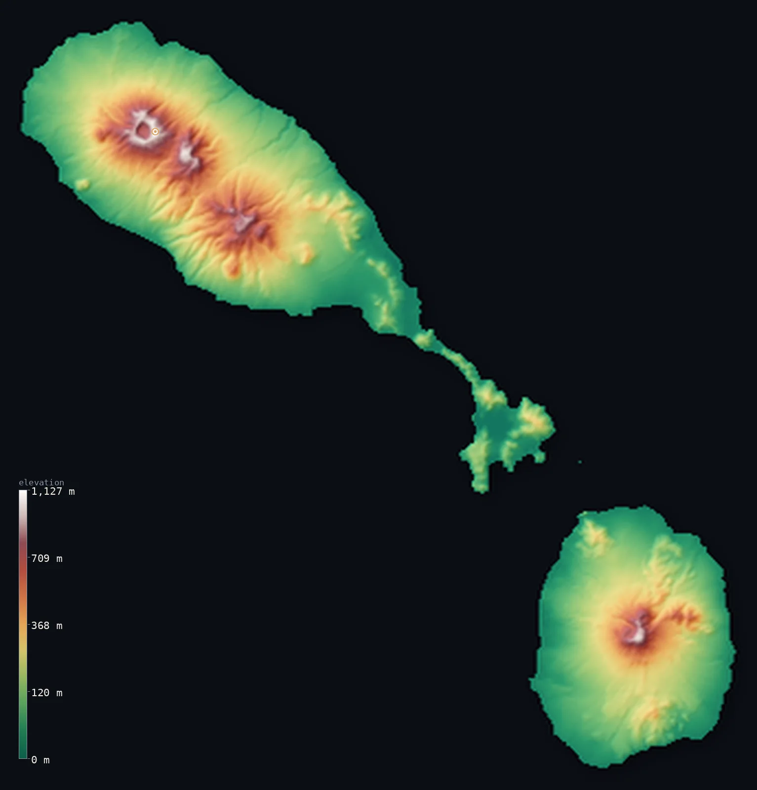
Saint Kitts and Nevis’s highest point is Mount Liamuiga at 3,793 ft (1,156 m); its lowest is Caribbean Sea at 0 ft (0 m); the mean elevation is 636 ft (194 m).
- Highest point📚
- 3,793 ft1,156 m
- Mount Liamuiga, the volcano at the northwest of Saint Kitts.
- Lowest point📚
- 0 ft0 m
- Sea level around both islands.
- Mean elevation⚙
- 636 ft194 m
- Computed from the GLO-30 surface model across the two islands.
- Median elevation⚙
- 410 ft125 m
- Half of Saint Kitts and Nevis lies below this height.
- Elevation range📚
- 3,793 ft1,156 m
- From the sea to Mount Liamuiga's 1,156 m.
- Above 1,000 m (3,281 ft)⚙
- <1%
- The volcanic spine of Saint Kitts and the cone of Nevis.
- Official area📚
- 101 mi²261 km²
- A small two-island federation of volcanic peaks in the Leeward Islands.
- Forest cover📚
- 42.3%
- Well over a third forested, dense on the upper volcanic slopes.
Highest and lowest points
The highest point of Saint Kitts and Nevis, Mount Liamuiga, 1,156 m, a forested stratovolcano forming the northwestern part of Saint Kitts, topped by a wide crater with a lake. It is the highest peak in the British Leeward Islands. Formerly called Mount Misery, it was renamed at independence in 1983; its last verified eruption was about 1,800 years ago.
source ↗Saint Kitts and Nevis at a glance
Mount Liamuiga is the highest peak in the entire British Leeward Islands, not just this federation.
source ↗The volcano was called Mount Misery until the country renamed it at independence in 1983.
source ↗The whole island of Nevis is effectively one volcanic cone rising straight from the sea.
source ↗Liamuiga's summit crater held a lake that drained in 1959 and had re-formed by 2006.
source ↗Saint Kitts and Nevis is the smallest country in the Americas by both area and population.
source ↗
Elevation profile of Saint Kitts and Nevis
The largest share of land, 43%, falls in the 0–100 m band, and 90% of the territory lies below 500 m (1,640 ft).
- below 500 m (1,640 ft)90%
- 500–1,000 m10%
- 1,000–2,000 m<1%
Highest peaks of Saint Kitts and Nevis
Terrain regions of Saint Kitts and Nevis
Mount Liamuiga is the highest peak in the entire British Leeward Islands, not just this federation. ↗
Saint Kitts
↗The larger island, a chain of volcanic peaks led by Mount Liamuiga, tailing southeast into a low peninsula of salt ponds and beaches.
Nevis
↗The near-circular sister island a few kilometres southeast, essentially one forested volcanic cone, Nevis Peak, ringed by coastal flats.
The coasts and lowlands
↗The coastal plains and black-sand beaches ringing both islands, once planted in sugar, where nearly all the population lives.
The volcanic range of Saint Kitts
the main islandThe larger island is built of three volcanic groups running northwest to southeast, the highest being Mount Liamuiga (1,156 m) at the northwestern end, a classic cone with a crater lake. Its steep upper slopes are wrapped in rainforest, falling to cultivated middle slopes and a long, low southeastern peninsula of dry scrub, salt ponds and beaches.
The cone of Nevis
the sister islandA few kilometres to the southeast across a shallow channel lies Nevis, an almost circular island that is essentially a single volcano, Nevis Peak (985 m), rising steeply from a narrow coastal apron. Cloud usually caps the forested summit, and hot springs on its flanks recall its volcanic nature.
The coasts and former sugar lands
the coastal fringeAround both islands the volcanic slopes give way to coastal plains of volcanic soil, once covered in sugar estates and now the site of most towns and roads. The beaches are largely black volcanic sand, and the low southeastern tip of Saint Kitts holds the islands' only real dry lowland.
City elevations in Saint Kitts and Nevis
| City | Population | Elevation |
|---|---|---|
| BasseterrecapitalBasseterre, the capital, lies on the south coast of Saint Kitts below the volcanic range. ↗ | 12,920 | 30 ft9 m |
| Fig Tree | 2,922 | 367 ft112 m |
| Saint Paul’s | 2,460 | 213 ft65 m |
Elevation sampled at each city centre from the Copernicus GLO-30 model. Cities and population from GeoNames (CC-BY 4.0).
Saint Kitts and Nevis in comparison
Saint Kitts and Nevis's terrain rises 3,793 ft (1,156 m) from sea level to Mount Liamuiga — about 13% of the height of Mount Everest, the world's highest point at 29,032 ft (8,849 m).
- Antigua and Barbuda's mean elevation is 91 ft — 546 ft lower; its high point, Boggy Peak (Mount Obama), reaches 1,319 ft (402 m), 2,474 ft below. Antigua and Barbuda elevation map →
- Dominica's mean elevation is 1,165 ft — 528 ft higher; its high point, Morne Diablotins, reaches 4,747 ft (1,447 m), 955 ft above. Dominica elevation map →
- Grenada's mean elevation is 666 ft — 30 ft higher; its high point, Mount St. Catherine, reaches 2,756 ft (840 m), 1,037 ft below. Grenada elevation map →
Frequently asked questions
What is the highest point in Saint Kitts and Nevis?
- Mount Liamuiga, 3,793 ft (1,156 m), a volcano at the northwestern end of Saint Kitts.
What is the average elevation of Saint Kitts and Nevis?
- No standard source publishes one, so this page reports the mean computed from the Copernicus GLO-30 model, 636 ft (194 m), across the two islands.
What is the lowest point in Saint Kitts and Nevis?
- Sea level - the Caribbean surrounds both islands.
How high is Nevis Peak?
- About 985 m; the island of Nevis is essentially this single volcanic cone.
Is Mount Liamuiga an active volcano?
- It is dormant - its last verified eruption was roughly 1,800 years ago - but it remains a geologically young stratovolcano with a crater lake.
Is this a topographic, relief, contour, or elevation map of Saint Kitts and Nevis?
- They describe the same thing - terrain height. This page renders the islands' actual elevation surface in interactive 3D (a relief or topographic view) and reports the statistics computed from it; a contour map shows the same data as lines of equal height.
About this map
The terrain is rendered from the Copernicus GLO-30 digital elevation model (ESA), masked to the KNA-ADM0 boundary from geoBoundaries (gbOpen). Elevation statistics are computed directly from the model; peak names and researched facts are sourced and cited. See the methodology for the full pipeline.
Our area-weighted mean, computed from the Copernicus GLO-30 model, is 636 ft (194 m); no authority publishes a mean elevation (No authoritative published mean elevation). No standard source publishes a mean elevation for this small two-island federation of volcanic peaks and coastal plains. The page reports the area-weighted figure computed from the Copernicus GLO-30 model.
Surveyed national figures: official area · forest cover · high point.
Rendered from Copernicus GLO-30 (ESA, 2021 release), boundaries from geoBoundaries. Generated 2026-07-09.