Dominica Elevation Map
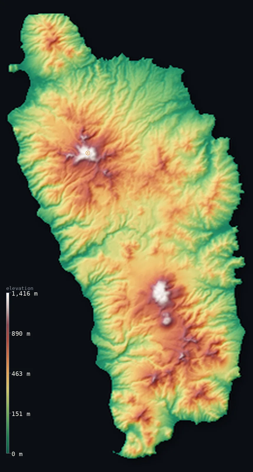
Dominica’s highest point is Morne Diablotins at 4,747 ft (1,447 m); its lowest is Caribbean Sea at 0 ft (0 m); the mean elevation is 1,165 ft (355 m).
- Highest point📚
- 4,747 ft1,447 m
- Morne Diablotins, a volcano in the northern interior.
- Lowest point📚
- 0 ft0 m
- Sea level along the island's cliffed coast.
- Mean elevation⚙
- 1,165 ft355 m
- Computed from the GLO-30 surface model across the island.
- Median elevation⚙
- 1,043 ft318 m
- Half of Dominica lies below this height.
- Elevation range📚
- 4,747 ft1,447 m
- From the sea to Morne Diablotins' 1,447 m, over a span of barely 30 km.
- Above 1,000 m (3,281 ft)⚙
- 1%
- The steep central volcanic spine running northwest–southeast.
- Official area📚
- 290 mi²750 km²
- A small, exceptionally steep volcanic island in the Lesser Antilles — 'The Nature Island'.
- Forest cover📚
- 64.3%
- Most of Dominica is rainforest — among the most heavily forested countries in the Caribbean.
Highest and lowest points
The highest point of Dominica at 1,447 m — Morne Diablotins, the island's largest volcano, in its northern interior, and the second-highest mountain in the Lesser Antilles. Its last eruption was about 30,000 years ago; it is named after the diablotin (black-capped petrel) and lies within Morne Diablotin National Park.
source ↗Dominica at a glance
Dominica is the most mountainous island in the Lesser Antilles — an island a bit bigger than Martha's Vineyard with peaks approaching 1,500 m.
source ↗It holds the world's second-largest hot spring — the Boiling Lake, a flooded fumarole of bubbling grey-blue water about 60 m across, wrapped in vapour.
source ↗Dominica is the youngest island in the Lesser Antilles, formed only about 26 million years ago and still being shaped by geothermal and volcanic activity.
source ↗It is nicknamed 'The Nature Island of the Caribbean' — largely rainforest, with an extensive park system protecting unusually rich flora and fauna.
source ↗The southwestern tip of the island, at Scotts Head, is the exposed rim of a collapsed submarine volcanic caldera.
source ↗Don't confuse it with the Dominican Republic — Dominica is a small volcanic island in the Lesser Antilles, about 1,000 km southeast of the much larger Dominican Republic on Hispaniola.
source ↗
Elevation profile of Dominica
The largest share of land, 16%, falls in the 200–300 m band, and 76% of the territory lies below 500 m (1,640 ft).
- below 500 m (1,640 ft)76%
- 500–1,000 m23%
- 1,000–2,000 m1%
Highest peaks of Dominica
| Peak | Elevation | Range | Note |
|---|---|---|---|
| Morne Diablotins↗ | 4,747 ft1,447 m | central volcanic spine (north) | Highest point of Dominica and second-highest in the Lesser Antilles, in Morne Diablotin National Park. |
| Morne Trois Pitons↗ | 4,669 ft1,423 m | central volcanic spine (south) | The 'mountain of three peaks', namesake of the UNESCO World Heritage national park with the Boiling Lake and Valley of Desolation on nearby slopes. |
| Watt Mountain↗ | 4,016 ft1,224 m | central volcanic spine (south) | Volcano whose slopes hold the Valley of Desolation and Boiling Lake — the world's second-largest hot spring. |
| Morne aux Diables↗ | 2,825 ft861 m | northern tip | A volcanic cone forming the far northern end of the island, above the Cabrits and Prince Rupert Bay. |
Terrain regions of Dominica
Dominica is the most mountainous island in the Lesser Antilles — an island a bit bigger than Martha's Vineyard with peaks approaching 1,500 m. ↗
Central volcanic spine
↗A northwest–southeast axis of steep volcanic peaks, lava-crater cones and deep gorges — Morne aux Diables, Morne Diablotins (1,447 m), Morne Trois Pitons and Morne Anglais — generally 300–1,400 m high, the backbone of the most mountainous island in the Lesser Antilles.
Morne Trois Pitons geothermal area (south)
↗The volcanic south, protected as a UNESCO World Heritage national park, holding the Boiling Lake (the world's second-largest hot spring), the Valley of Desolation's boiling mud and fumaroles, Titou Gorge and Emerald Pool.
Coasts and gorges
↗A narrow coastal plain studded with sea cliffs, ringing the island in level strips rarely wider than 2 km; the southwestern tip at Scotts Head is the exposed rim of a collapsed submarine caldera. Swift rivers cascade through deep gorges to both coasts.
The volcanic spine
the island's interior backboneDominica is essentially one continuous mountain range — a steep northwest–southeast volcanic spine of lava-crater cones and deep gorges, mostly 300–1,400 m high. It is the most mountainous island in the Lesser Antilles and the youngest, formed only about 26 million years ago and still volcanically alive. Morne Diablotins (1,447 m) crowns the north; Morne Trois Pitons and others rise to the south.
Geothermal south and Morne Trois Pitons park
southern volcanic highlandsThe south is intensely geothermal, protected within Morne Trois Pitons National Park, a UNESCO World Heritage Site. Here lie the Boiling Lake — a flooded fumarole of bubbling grey-blue water, the world's second-largest hot spring — the steaming Valley of Desolation, Titou Gorge and Emerald Pool. Sulphur springs and steam vents are scattered across the central and southern island, though lava eruptions ceased thousands of years ago.
Coasts, cliffs and rivers
narrow coastal fringeThe mountains drop quickly to a narrow coastal plain of sea cliffs and short level strips. Black, grey and white volcanic-sand beaches line the shore; Scotts Head at the southwest tip is the rim of a collapsed undersea caldera. Dominica is water-rich, with many swift, non-navigable rivers — the Layou and Roseau running west to the Caribbean, the Toulaman east to the Atlantic — cascading through gorges as waterfalls like Trafalgar Falls.
City elevations in Dominica
| City | Population | Elevation |
|---|---|---|
| RoseaucapitalRoseau, the capital and main port, sits on the sheltered southwestern coast at the mouth of the Roseau River, backed almost immediately by steep volcanic slopes. ↗ | 16,571 | 26 ft8 m |
| Portsmouth | 3,633 | 98 ft30 m |
| Marigot | 2,669 | 269 ft82 m |
| Salisbury | 1,413 | 135 ft41 m |
| La Plaine | 1,332 | 302 ft92 m |
Elevation sampled at each city centre from the Copernicus GLO-30 model. Cities and population from GeoNames (CC-BY 4.0).
Dominica in comparison
Dominica's terrain rises 4,747 ft (1,447 m) from sea level to Morne Diablotins — about 16% of the height of Mount Everest, the world's highest point at 29,032 ft (8,849 m).
- Dominican Republic's mean elevation is 1,309 ft — 144 ft higher; its high point, Pico Duarte, reaches 10,164 ft (3,098 m), 5,417 ft above. Dominican Republic elevation map →
- Saint Lucia's mean elevation is 541 ft — 623 ft lower; its high point, Mount Gimie, reaches 3,117 ft (950 m), 1,631 ft below. Saint Lucia elevation map →
- Grenada's mean elevation is 666 ft — 499 ft lower; its high point, Mount St. Catherine, reaches 2,756 ft (840 m), 1,991 ft below. Grenada elevation map →
Frequently asked questions
What is the highest point in Dominica?
- Morne Diablotins, 4,747 ft (1,447 m), a volcano in the northern interior — the second-highest mountain in the Lesser Antilles.
What is the average elevation of Dominica?
- The island is a steep volcanic spine with almost no flat land, so no single published mean represents it well; this page reports the area-weighted mean of 1,165 ft (355 m) computed from the Copernicus GLO-30 model.
Is Dominica volcanic?
- Very — it is the youngest island in the Lesser Antilles volcanic arc, with a spine of volcanic cones and active geothermal features like the Boiling Lake and Valley of Desolation, though lava eruptions ceased thousands of years ago.
What is the lowest point in Dominica?
- Sea level, along the island's narrow, cliff-lined coast on the Caribbean and Atlantic.
What is the Boiling Lake?
- A flooded fumarole in Morne Trois Pitons National Park — the world's second-largest hot spring, a cauldron of bubbling grey-blue water about 60 m across, usually shrouded in vapour.
How is Dominica different from the Dominican Republic?
- They are entirely separate countries. Dominica is a small volcanic island in the Lesser Antilles; the Dominican Republic is a much larger country about 1,000 km northwest, sharing the island of Hispaniola with Haiti.
Why is Dominica called the Nature Island?
- For its lush rainforest, rivers and waterfalls and exceptional biodiversity, protected by an extensive national park system across its volcanic terrain.
Is this a topographic, relief, contour, or elevation map of Dominica?
- They describe the same thing — terrain height. This page renders Dominica's actual elevation surface in interactive 3D (a relief or topographic view) and reports the elevation statistics computed from it; a contour map shows the same data as lines of equal height.
About this map
The terrain is rendered from the Copernicus GLO-30 digital elevation model (ESA), masked to the DMA-ADM0 boundary from geoBoundaries (gbOpen). Elevation statistics are computed directly from the model; peak names and researched facts are sourced and cited. See the methodology for the full pipeline.
Our area-weighted mean, computed from the Copernicus GLO-30 model, is 1,165 ft (355 m); no authority publishes a mean elevation (no authoritative published mean). Dominica is a small, steep volcanic island whose central spine runs from the coast to nearly 1,500 m with almost no flat land, so there is no single representative published mean elevation; the page reports the area-weighted figure computed from the Copernicus GLO-30 model.
Surveyed national figures: official area · forest cover · high point.
Rendered from Copernicus GLO-30 (ESA, 2021 release), boundaries from geoBoundaries. Generated 2026-06-22.