Saint Lucia Elevation Map
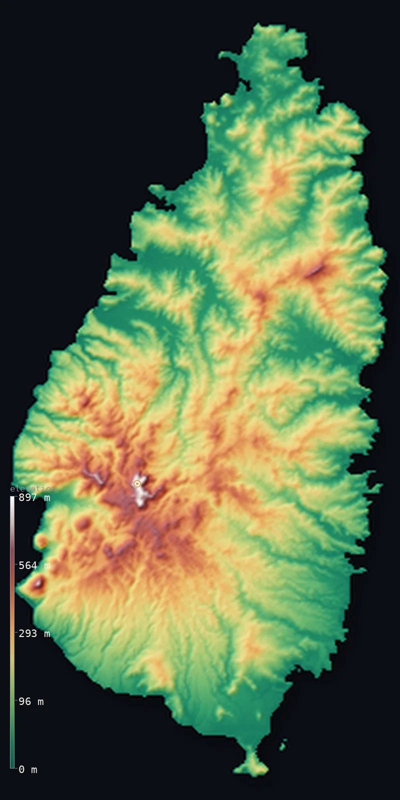
Saint Lucia’s highest point is Mount Gimie at 3,117 ft (950 m); its lowest is Caribbean Sea at 0 ft (0 m); the mean elevation is 541 ft (165 m).
- Highest point📚
- 3,117 ft950 m
- Mount Gimie, in the forested interior.
- Lowest point📚
- 0 ft0 m
- Sea level around the island.
- Mean elevation⚙
- 541 ft165 m
- Computed from the GLO-30 surface model across the island.
- Median elevation⚙
- 443 ft135 m
- Half of Saint Lucia lies below this height.
- Elevation range📚
- 3,117 ft950 m
- From the sea to Mount Gimie's 950 m.
- Official area📚
- 238 mi²616 km²
- A small, rugged volcanic island of the Lesser Antilles.
- Forest cover📚
- 33.3%
- About a third forested, dense across the mountainous core.
Highest and lowest points
The highest point of Saint Lucia, Mount Gimie, 950 m, deep in the island's interior within the Central Forest Reserve. It is a dormant, eroded volcanic peak belonging to the same volcanic complex as the famous Pitons, forming part of the rainforested spine that runs down the island. An interior summit.
source ↗Saint Lucia at a glance
The twin Pitons, though lower than Mount Gimie, are the island's emblem and a UNESCO World Heritage Site.
source ↗At Soufriere a geothermal field billed as a drive-in volcano lets visitors approach steaming vents by road.
source ↗Almost the entire island is volcanic and mountainous, with very little flat land.
source ↗Mount Gimie belongs to the same volcanic complex that produced the far more famous Pitons.
source ↗Saint Lucia changed hands between Britain and France fourteen times before becoming British.
source ↗
Elevation profile of Saint Lucia
The largest share of land, 40%, falls in the 0–100 m band, and 98% of the territory lies below 500 m (1,640 ft).
- below 500 m (1,640 ft)98%
- 500–1,000 m2%
Highest peaks of Saint Lucia
| Peak | Elevation | Range | Note |
|---|---|---|---|
| Mount Gimie↗ | 3,117 ft950 m | Central volcanic spine | Highest point of Saint Lucia, in the interior Central Forest Reserve. |
| Gros Piton↗ | 2,530 ft771 m | The Pitons | The larger of the two Pitons, a sheer volcanic plug on the southwest coast and a UNESCO World Heritage landmark. |
| Petit Piton↗ | 2,438 ft743 m | The Pitons | The slenderer of the twin Pitons, rising almost vertically from the sea beside Soufriere. |
Terrain regions of Saint Lucia
The twin Pitons, though lower than Mount Gimie, are the island's emblem and a UNESCO World Heritage Site. ↗
The volcanic interior
↗The rainforested central spine of the island, rising to Mount Gimie and protected largely within the Central Forest Reserve.
The Soufriere volcanic centre and Pitons
↗The southwest, where the twin Pitons rise sheer from the sea beside the town of Soufriere and the Sulphur Springs, the island's still-warm volcanic heart.
The coasts and valleys
↗The coastal lowlands, bays and river valleys ringing the island, holding Castries and most of the towns and farmland.
The volcanic interior
the mountainous coreSaint Lucia is a wholly volcanic island whose rugged core rises to Mount Gimie (950 m) amid the rainforest of the Central Forest Reserve. From this high, cloud-wrapped spine a tangle of steep ridges and deep valleys radiates outward, so that little of the island is truly flat. The interior is dormant but geologically young, deeply eroded rather than extinct.
The Soufriere volcanic centre and the Pitons
the southwestOn the southwest coast stands the island's most striking scenery - the twin Pitons, Gros Piton (771 m) and Petit Piton (743 m), sheer volcanic plugs rising almost vertically from the sea and listed as a UNESCO World Heritage Site. Beside them, the Sulphur Springs at Soufriere vent steam and hot mud, the surface expression of a still-warm volcanic system often called a drive-in volcano.
The coasts and valleys
the coastal fringeRinging the mountains is a fringe of coastal lowland, bays and river valleys where nearly all the towns, roads and farmland lie. The northwest holds the capital, Castries, on a deep natural harbour, while banana plantations fill the wider valleys. The coast alternates between calm western bays and a more exposed Atlantic east.
City elevations in Saint Lucia
| City | Population | Elevation |
|---|---|---|
| CastriescapitalCastries, the capital, lies on a sheltered harbour on the northwest coast below the hills. ↗ | 20,000 | 344 ft105 m |
| Dennery | 12,589 | 102 ft31 m |
| Laborie | 6,701 | 89 ft27 m |
Elevation sampled at each city centre from the Copernicus GLO-30 model. Cities and population from GeoNames (CC-BY 4.0).
Saint Lucia in comparison
Saint Lucia's terrain rises 3,117 ft (950 m) from sea level to Mount Gimie — about 11% of the height of Mount Everest, the world's highest point at 29,032 ft (8,849 m).
- Dominica's mean elevation is 1,165 ft — 623 ft higher; its high point, Morne Diablotins, reaches 4,747 ft (1,447 m), 1,631 ft above. Dominica elevation map →
- Saint Vincent and the Grenadines's mean elevation is 1,053 ft — 512 ft higher; its high point, La Soufriere, reaches 4,049 ft (1,234 m), 932 ft above. Saint Vincent and the Grenadines elevation map →
- Grenada's mean elevation is 666 ft — 125 ft higher; its high point, Mount St. Catherine, reaches 2,756 ft (840 m), 361 ft below. Grenada elevation map →
Frequently asked questions
What is the highest point in Saint Lucia?
- Mount Gimie, 3,117 ft (950 m), in the forested interior of the island.
What is the average elevation of Saint Lucia?
- No standard source publishes one, so this page reports the mean computed from the Copernicus GLO-30 model, 541 ft (165 m), across the island.
What is the lowest point in Saint Lucia?
- Sea level, along the Caribbean and Atlantic coasts.
How tall are the Pitons?
- Gros Piton is about 771 m and Petit Piton about 743 m - lower than Mount Gimie, but far more famous as sheer plugs rising straight from the sea.
Is Saint Lucia volcanic?
- Entirely - the island is built of volcanic rock, and the Soufriere area still vents steam and hot mud from a dormant but warm system.
Is this a topographic, relief, contour, or elevation map of Saint Lucia?
- They describe the same thing - terrain height. This page renders Saint Lucia's actual elevation surface in interactive 3D (a relief or topographic view) and reports the statistics computed from it; a contour map shows the same data as lines of equal height.
About this map
The terrain is rendered from the Copernicus GLO-30 digital elevation model (ESA), masked to the LCA-ADM0 boundary from geoBoundaries (gbOpen). Elevation statistics are computed directly from the model; peak names and researched facts are sourced and cited. See the methodology for the full pipeline.
Our area-weighted mean, computed from the Copernicus GLO-30 model, is 541 ft (165 m); no authority publishes a mean elevation (No authoritative published mean elevation). No standard source publishes a mean elevation for Saint Lucia, a small, wholly volcanic and mountainous island. The page reports the area-weighted figure computed from the Copernicus GLO-30 model.
Surveyed national figures: official area · forest cover · high point.
Rendered from Copernicus GLO-30 (ESA, 2021 release), boundaries from geoBoundaries. Generated 2026-07-09.