Saint Vincent and the Grenadines Elevation Map
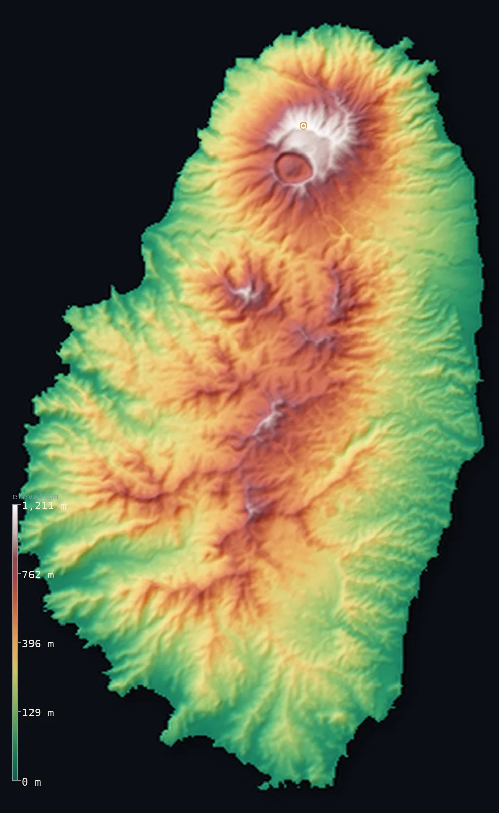
Saint Vincent and the Grenadines’s highest point is La Soufriere at 4,049 ft (1,234 m); its lowest is Caribbean Sea at 0 ft (0 m); the mean elevation is 1,053 ft (321 m).
- Highest point📚
- 4,049 ft1,234 m
- La Soufriere volcano, at the north of Saint Vincent.
- Lowest point📚
- 0 ft0 m
- Sea level around the islands.
- Mean elevation⚙
- 1,053 ft321 m
- Computed from the GLO-30 surface model across the islands.
- Median elevation⚙
- 876 ft267 m
- Half of Saint Vincent and the Grenadines lies below this height.
- Elevation range📚
- 4,049 ft1,234 m
- From the sea to La Soufriere's 1,234 m.
- Above 1,000 m (3,281 ft)⚙
- 1%
- The volcanic ranges of Saint Vincent.
- Official area📚
- 150 mi²389 km²
- A volcanic main island with a chain of small southern isles.
- Forest cover📚
- 68.7%
- Heavily forested, over two-thirds, across the mountainous main island.
Highest and lowest points
The highest point of Saint Vincent and the Grenadines, La Soufriere, 1,234 m, an active volcano occupying the northern end of the main island of Saint Vincent. It is the southernmost 1,000 m summit in the Caribbean and erupted as recently as 2021. An interior summit on the largest island.
source ↗Saint Vincent and the Grenadines at a glance
La Soufriere is an active volcano and erupted explosively as recently as April 2021.
source ↗It is the southernmost summit over 1,000 m anywhere in the Caribbean.
source ↗The country strings together one mountainous main island and dozens of small Grenadine isles to its south.
source ↗Over two-thirds of the land is forested, among the highest shares in the Caribbean.
source ↗The 1902 eruption of La Soufriere, days before Mont Pelee, killed some 1,600 people.
source ↗
Elevation profile of Saint Vincent and the Grenadines
The largest share of land, 21%, falls in the 0–100 m band, and 76% of the territory lies below 500 m (1,640 ft).
- below 500 m (1,640 ft)76%
- 500–1,000 m23%
- 1,000–2,000 m1%
Highest peaks of Saint Vincent and the Grenadines
| Peak | Elevation | Range | Note |
|---|---|---|---|
| La Soufriere↗ | 4,049 ft1,234 m | Saint Vincent volcanic range | Highest point of the country, an active volcano at the north of Saint Vincent; last erupted in 2021. |
| Richmond Peak↗ | 3,540 ft1,079 m | Saint Vincent volcanic range | The second-highest summit on Saint Vincent, on the forested ridge south of La Soufriere. |
Terrain regions of Saint Vincent and the Grenadines
La Soufriere is an active volcano and erupted explosively as recently as April 2021. ↗
The volcanic north of Saint Vincent
↗The high, forested northern half of the main island, dominated by the active La Soufriere volcano and its lava-scarred slopes.
The southern ranges and valleys
↗The lower southern half of Saint Vincent, a country of ridges and valleys holding Kingstown and most of the population and farmland.
The Grenadines
↗The chain of small, drier islands running south from Saint Vincent - Bequia, Mustique, Canouan, Union and others - low and hilly rather than mountainous.
The volcanic north of Saint Vincent
the north of the main islandThe northern half of the main island is a young, steep volcanic massif crowned by La Soufriere (1,234 m), an active volcano that erupted explosively as recently as April 2021. Its upper slopes are bare lava and ash, its lower flanks dense rainforest. This is the highest and wildest part of the country, largely uninhabited.
The southern ranges and valleys
the south of the main islandSouth of the volcano, Saint Vincent settles into a rugged landscape of forested ridges and deep valleys descending to the coast, reaching secondary summits such as Richmond Peak (1,079 m). The sheltered south coast holds the capital, Kingstown, and most of the island's people, roads and farmland, including its banana and arrowroot lands.
The Grenadines
the southern island chainTrailing south from Saint Vincent is a chain of small islands, the northern Grenadines - Bequia, Mustique, Canouan, Mayreau, Union Island and many islets. Unlike the towering main island these are low and hilly, drier, and fringed with reefs and white-sand beaches. They rise only a few hundred metres at most and sit far enough offshore to lie beyond the main island in this view.
City elevations in Saint Vincent and the Grenadines
Saint Vincent and the Grenadines in comparison
Saint Vincent and the Grenadines's terrain rises 4,049 ft (1,234 m) from sea level to La Soufriere — about 14% of the height of Mount Everest, the world's highest point at 29,032 ft (8,849 m).
- Saint Lucia's mean elevation is 541 ft — 512 ft lower; its high point, Mount Gimie, reaches 3,117 ft (950 m), 932 ft below. Saint Lucia elevation map →
- Grenada's mean elevation is 666 ft — 387 ft lower; its high point, Mount St. Catherine, reaches 2,756 ft (840 m), 1,293 ft below. Grenada elevation map →
- Dominica's mean elevation is 1,165 ft — 112 ft higher; its high point, Morne Diablotins, reaches 4,747 ft (1,447 m), 699 ft above. Dominica elevation map →
Frequently asked questions
What is the highest point in Saint Vincent and the Grenadines?
- La Soufriere, 4,049 ft (1,234 m), an active volcano at the north of the main island of Saint Vincent.
What is the average elevation of Saint Vincent and the Grenadines?
- No standard source publishes one, so this page reports the mean computed from the Copernicus GLO-30 model, 1,053 ft (321 m), across the islands.
What is the lowest point in Saint Vincent and the Grenadines?
- Sea level - the sea surrounds the main island and every Grenadine.
Is La Soufriere still active?
- Yes - it is an active volcano that erupted explosively in April 2021, and destructively in 1902 and 1979.
Are the Grenadines mountainous?
- No - unlike volcanic Saint Vincent, the Grenadines are low, dry, hilly islands rising only a few hundred metres.
Is this a topographic, relief, contour, or elevation map of Saint Vincent and the Grenadines?
- They describe the same thing - terrain height. This page renders the islands' actual elevation surface in interactive 3D (a relief or topographic view) and reports the statistics computed from it; a contour map shows the same data as lines of equal height.
About this map
The terrain is rendered from the Copernicus GLO-30 digital elevation model (ESA), masked to the VCT-ADM0 boundary from geoBoundaries (gbOpen). Elevation statistics are computed directly from the model; peak names and researched facts are sourced and cited. See the methodology for the full pipeline.
This map renders 345 km² of Saint Vincent and the Grenadines. 7 smaller outlying parts — 43 km² in total — lie beyond the area shown here. Area statistics above count the full territory.
Our area-weighted mean, computed from the Copernicus GLO-30 model, is 1,053 ft (321 m); no authority publishes a mean elevation (No authoritative published mean elevation). No standard source publishes a mean elevation for this volcanic main island and its chain of small southern islands. The page reports the area-weighted figure computed from the Copernicus GLO-30 model.
Surveyed national figures: official area · forest cover · high point.
Rendered from Copernicus GLO-30 (ESA, 2021 release), boundaries from geoBoundaries. Generated 2026-07-09.