Grenada Elevation Map
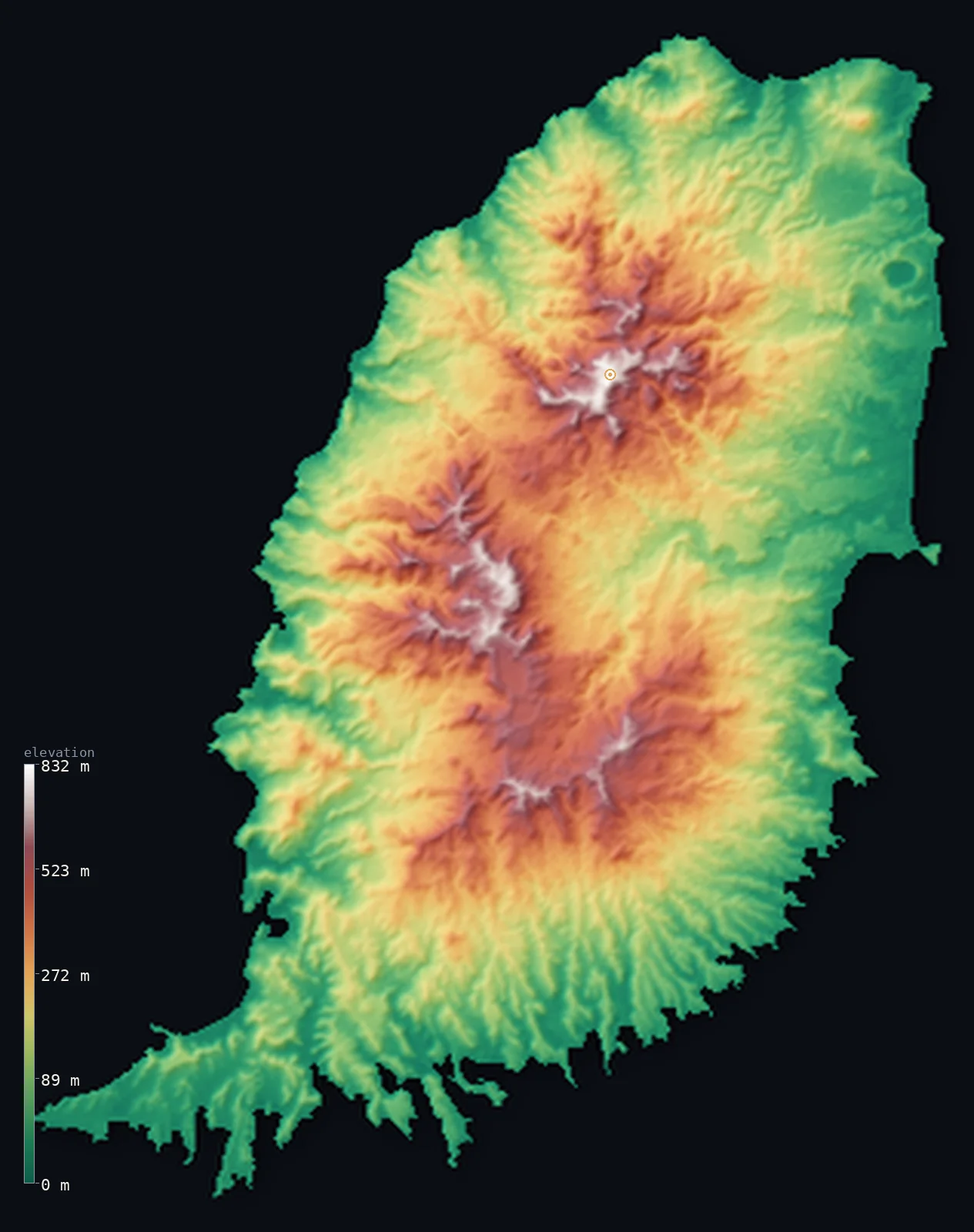
Grenada’s highest point is Mount St. Catherine at 2,756 ft (840 m); its lowest is Caribbean Sea / Atlantic Ocean at 0 ft (0 m); the mean elevation is 666 ft (203 m).
- Highest point📚
- 2,756 ft840 m
- Mount St. Catherine, a dormant volcano in the north-central interior.
- Lowest point📚
- 0 ft0 m
- Sea level along the Caribbean and Atlantic coasts.
- Mean elevation⚙
- 666 ft203 m
- Computed from the GLO-30 surface model across the islands.
- Median elevation⚙
- 515 ft157 m
- Half of Grenada lies below this height.
- Elevation range📚
- 2,756 ft840 m
- From the sea to Mount St. Catherine's 840 m.
- Official area📚
- 133 mi²344 km²
- A small volcanic island nation at the south end of the Windward Islands.
- Forest cover📚
- 53%
- About half is forest, dense rainforest cloaking the mountainous interior.
Highest and lowest points
The highest point of Grenada at 840 m - Mount St. Catherine, a dormant, weathered stratovolcano in the north-central interior of the main island and the youngest of the island's five volcanic centres. A national report gives 833 m. It is an interior summit on a single island.
source ↗Grenada at a glance
Grenada is entirely volcanic - the main island has five old volcanic centres and several crater lakes, and the highest, Mount St. Catherine, still has hot springs and fumaroles on its flanks.
source ↗About three-quarters of Grenada lies below 305 m, and only about 1.6% rises above 610 m - the high ground is concentrated in the island's volcanic spine.
source ↗The Grand Etang Lake, near the centre of the island, fills a volcanic crater more than 500 m above sea level, surrounded by rainforest.
source ↗Just north of Grenada lies Kick 'em Jenny, one of the most active submarine volcanoes in the Caribbean, which has erupted repeatedly underwater.
source ↗Known as the 'Island of Spice', Grenada is one of the world's leading producers of nutmeg and mace, grown on its fertile volcanic slopes.
source ↗Grenada is the southernmost of the Windward Islands, lying only about 140 km north of Venezuela and Trinidad.
source ↗
Elevation profile of Grenada
The largest share of land, 36%, falls in the 0–100 m band, and 92% of the territory lies below 500 m (1,640 ft).
- below 500 m (1,640 ft)92%
- 500–1,000 m8%
Highest peaks of Grenada
| Peak | Elevation | Range | Note |
|---|---|---|---|
| Mount St. Catherine↗ | 2,756 ft840 m | Grenada interior (volcanic) | Highest point of Grenada, a dormant stratovolcano with a horseshoe crater in the north-centre of the main island. |
| Fedon's Camp↗ | 2,516 ft767 m | Grand Etang highlands | A peak in the Grand Etang interior, a stronghold in Grenada's 1795-96 Fedon rebellion. |
| Mount Qua Qua↗ | 2,411 ft735 m | Grand Etang highlands | A popular hiking peak overlooking the Grand Etang crater lake in the island's interior. |
| Mount Sinai↗ | 2,300 ft701 m | Grand Etang highlands | One of the high peaks of the Grand Etang Forest Reserve in central Grenada. |
Terrain regions of Grenada
Grenada is entirely volcanic - the main island has five old volcanic centres and several crater lakes, and the highest, Mount St. Catherine, still has hot springs and fumaroles on its flanks. ↗
The main island of Grenada
↗The rugged volcanic main island - a north-south spine of ridges and narrow valleys rising to Mount St. Catherine (840 m), with crater lakes (Grand Etang, Lake Antoine) and dense rainforest, ringed by a narrow coastal plain.
Carriacou and Petite Martinique
↗The dependency islands at the south end of the Grenadines, about 30-40 km northeast - lower and drier, with Carriacou's High North reaching only about 291 m.
The volcanic interior
the mountainous core of the main islandThe main island of Grenada is of volcanic origin, with a mountainous interior running on a north-south axis of ridges and steep, narrow valleys. The highest point, Mount St. Catherine (840 m), is a dormant stratovolcano in the north-centre with a horseshoe-shaped crater. The Grand Etang highlands to the south hold a crater lake and several peaks above 700 m, all cloaked in rainforest.
The crater lakes and rainforest
the central uplandsThe high centre of the island is cloaked in rainforest and dotted with old volcanic craters. The best known is Grand Etang, a lake filling an extinct crater at around 530 m within the Grand Etang Forest Reserve, ringed by steep forested slopes. This wet, cool upland belt lies between the highest peaks and the farmed lower ground, feeding the short rivers that run down to the coast.
The coastal plain and the sister islands
the coastal margin and outlying islandsA narrow coastal plain rings the main island, cut by many short rivers descending the slopes - St. George's, the capital, sits on the southwest coast. To the northeast lie the dependency islands of Carriacou and Petite Martinique, the southern tip of the Grenadines chain - lower and less rugged, reaching only about 291 m.
City elevations in Grenada
| City | Population | Elevation |
|---|---|---|
| Saint George'scapital | 7,500 | 69 ft21 m |
| Grenville | 2,476 | 59 ft18 m |
Elevation sampled at each city centre from the Copernicus GLO-30 model. Cities and population from GeoNames (CC-BY 4.0).
Grenada in comparison
Grenada's terrain rises 2,756 ft (840 m) from sea level to Mount St. Catherine — about 9% of the height of Mount Everest, the world's highest point at 29,032 ft (8,849 m).
- Saint Vincent and the Grenadines's mean elevation is 1,053 ft — 387 ft higher; its high point, La Soufriere, reaches 4,049 ft (1,234 m), 1,293 ft above. Saint Vincent and the Grenadines elevation map →
- Barbados's mean elevation is 341 ft — 325 ft lower; its high point, Mount Hillaby, reaches 1,115 ft (340 m), 1,640 ft below. Barbados elevation map →
- Trinidad and Tobago's mean elevation is 273 ft — 393 ft lower; its high point, El Cerro del Aripo, reaches 3,084 ft (940 m), 328 ft above. Trinidad and Tobago elevation map →
Frequently asked questions
What is the highest point in Grenada?
- Mount St. Catherine, 2,756 ft (840 m), a dormant volcano in the north-central interior of the main island.
Is Mount St. Catherine a volcano?
- Yes - a dormant, weathered stratovolcano with a horseshoe-shaped crater, the youngest of the five volcanic centres that built the island, still showing hot springs and fumaroles.
What is the average elevation of Grenada?
- Computed from the Copernicus GLO-30 model, the area-weighted mean is 666 ft (203 m). Most of Grenada is low coastal land, so the mean is low.
What is the lowest point in Grenada?
- Sea level, along its Caribbean (west) and Atlantic (east) coasts.
How big is Grenada?
- About 344 km2 in all - the mountainous main island plus the smaller dependency islands of Carriacou and Petite Martinique to the northeast.
Is this a topographic, relief, contour, or elevation map of Grenada?
- They describe the same thing - terrain height. This page renders Grenada's actual elevation surface in interactive 3D (a relief or topographic view) and reports the elevation statistics computed from it; a contour map shows the same data as lines of equal height.
About this map
The terrain is rendered from the Copernicus GLO-30 digital elevation model (ESA), masked to the GRD-ADM0 boundary from geoBoundaries (gbOpen). Elevation statistics are computed directly from the model; peak names and researched facts are sourced and cited. See the methodology for the full pipeline.
Our area-weighted mean, computed from the Copernicus GLO-30 model, is 666 ft (203 m); no authority publishes a mean elevation (No authoritative published mean elevation). Grenada rises from a narrow coastal plain to a mountainous volcanic interior - about three-quarters of the land lies below 305 m and only a small fraction above 610 m - so the mean elevation is low; the page reports the area-weighted figure computed from the Copernicus GLO-30 model.
Surveyed national figures: official area · forest cover · high point.
Rendered from Copernicus GLO-30 (ESA, 2021 release), boundaries from geoBoundaries. Generated 2026-07-09.