Trinidad and Tobago Elevation Map — Topographic & 3D Terrain
Explore the terrain of Trinidad and Tobago in interactive 3D, built from Copernicus GLO-30 satellite elevation data — a low island off the coast of Venezuela, crossed by the Northern Range. Drag to rotate, scroll to zoom, and tap any point to read its elevation.
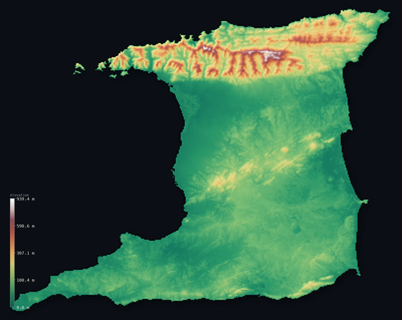
Trinidad and Tobago’s highest point is El Cerro del Aripo at 3,084 ft (940 m); its lowest is Caribbean Sea at 0 ft (0 m); the mean elevation is 273 ft (83.3 m).
Trinidad and Tobago is the southernmost country in the Caribbean, lying just off the coast of Venezuela — and geologically a piece of South America rather than a true Antillean island, cut off from the mainland only recently. Trinidad, the larger island, is mostly low: broad, flat central and southern plains of farmland and swamp, low and close to the sea. Along the north, though, runs the Northern Range — a steep, forested ridge, a continuation of the Venezuelan coastal mountains, holding the country's highest point, El Cerro del Aripo, at 3,084 ft (940 m). So the island is low with a high northern edge: about half of it lies below about 150 ft, in the central and southern plains. (Its smaller sister island, Tobago, lies to the northeast and is not shown in this view.)
- Highest point📚
- 3,084 ft940 m
- The country's highest point is El Cerro del Aripo at 3,084 ft (940 m), in the Northern Range of Trinidad — the steep, forested mountain ridge that runs along the island's north coast. The Northern Range is a continuation of the coastal cordillera of Venezuela, geologically part of the South American mainland, and Aripo is its highest summit, rising in dense rainforest above the low plains that make up most of the island.
- Lowest point📚
- 0 ft0 m
- The country's lowest point is the sea at sea level, around the coasts — and much of Trinidad lies only a little above it: broad, flat central and southern plains, some of it swamp and mangrove (the Caroni and Nariva wetlands), close to the sea. Only the Northern Range and lower central and southern hills rise much above the coastal lowlands.
- Mean elevation⚙
- 273 ft83.3 m
- Computed from the GLO-30 model, Trinidad's mean elevation is 273 ft (83.3 m) — a low figure, for the island is mostly low: broad central and southern plains, close to the sea, make up most of it, with the Northern Range along the north the one area of real height lifting the average. About half the island lies below about 154 ft (46.9 m).
- Median elevation⚙
- 154 ft46.9 m
- Half of Trinidad lies below about 154 ft (46.9 m) — a low figure, because the island is mostly low plains: the flat central and southern lowlands, some of them swamp, cover most of it, and only the Northern Range along the north coast, with lower central and southern hills, rises well above.
- Elevation range📚
- 3,084 ft940 m
- From the sea to the summit of El Cerro del Aripo at 940 m, Trinidad's terrain climbs about 3,084 ft — but the island is mostly low: the rise is concentrated in the Northern Range along the north coast, above the broad low plains that make up the rest of Trinidad.
- Above 50 m (164 ft)⚙
- 47%
- About 47% of Trinidad rises above 164 ft (50 m) — the Northern Range along the north and the lower central and southern hills. The broad central and southern coastal plains, much of the island, lie below.
- Official area📚
- 1,980 mi²5,128 km²
- Trinidad and Tobago covers about 1,980 sq mi (5,128 sq km) — the southernmost Caribbean country, off the coast of Venezuela: the larger island of Trinidad, mostly low central and southern plains with the steep Northern Range along its north coast (holding El Cerro del Aripo), and the smaller island of Tobago to the northeast.
- Forest cover📚
- 45.8%
- About 46% of Trinidad and Tobago is forested — dense rainforest on the steep Northern Range, mangrove and swamp forest in the coastal wetlands (the Caroni and Nariva), and much of the central and southern plains under farmland, with oil and gas fields in the south.
Highest and lowest points
The country's highest point is El Cerro del Aripo, 3,084 ft (940 m), in the Northern Range of Trinidad. The Northern Range is a steep, forested ridge running the length of the island's north coast — and geologically it is not an island mountain at all but a continuation of the coastal cordillera of Venezuela, for Trinidad sits on the South American continental shelf and was joined to the mainland until geologically recent times. Aripo is the range's highest summit, rising in dense rainforest above the low central and southern plains that make up most of Trinidad. Beyond the Northern Range, the island's central and southern hills are much lower. So the country's roof is a piece of the South American coastal mountains, standing along the northern edge of an otherwise low island. (The smaller island of Tobago, to the northeast, has its own low central ridge, and is not shown in this view.)
source ↗Trinidad's lowest point is the sea at sea level, and much of the island lies close to it. Unlike the volcanic and limestone islands of the rest of the Caribbean, Trinidad and Tobago sits on the continental shelf of South America — it is, geologically, a piece of the mainland, separated from Venezuela only in geologically recent times, and the Orinoco's waters still colour the sea around it. Most of Trinidad is low: broad, flat plains across the centre and south, including large wetlands — the Caroni Swamp on the west coast, the Nariva Swamp on the east — close to the sea. But along the north coast runs the Northern Range, a steep, forested mountain ridge that is a continuation of the coastal cordillera of Venezuela, holding El Cerro del Aripo (940 m, the country's highest point). Lower ranges of hills cross the centre and south. So Trinidad is mostly a low, plains-and-swamp island with a steep mountain wall along its northern edge. Its smaller sister island, Tobago, lies to the northeast, and is not shown in this view, which renders the Trinidad mainland.
source ↗Trinidad and Tobago at a glance
Trinidad and Tobago sits on the continental shelf of South America - geologically a piece of the mainland, separated from Venezuela only in geologically recent times, unlike the volcanic and limestone islands of the rest of the Caribbean.
source ↗Trinidad's highest point, El Cerro del Aripo (940 m), is in the Northern Range - a continuation of the coastal mountains of Venezuela, running along the island's north coast.
source ↗Most of Trinidad is low - broad, flat central and southern plains, including the great Caroni and Nariva wetlands, close to the sea.
source ↗The Pitch Lake in southwestern Trinidad is the largest natural deposit of asphalt in the world - a lake of tar, tied to the island's rich oil and gas geology.
source ↗Trinidad and Tobago is the southernmost country in the Caribbean - lying just off the coast of Venezuela, across the shallow Gulf of Paria.
source ↗The island's Caroni and Nariva swamps are great coastal wetlands - home to the scarlet ibis, the national bird, which roosts in the Caroni mangroves in flocks.
source ↗
Elevation profile of Trinidad and Tobago
The largest share of land, 79%, falls in the 0–100 m band, and 99% of the territory lies below 500 m (1,640 ft).
- 0–10 m (0–33 ft)10%
- 10–50 m (33–164 ft)43%
- above 50 m (164 ft)47%
Highest peaks of Trinidad and Tobago
| Peak | Elevation | Range | Note |
|---|---|---|---|
| El Cerro del Aripo↗ | 3,084 ft940 m | Northern Range (Trinidad) | Highest point of Trinidad and Tobago, a flat, cloud-forested summit in the Aripo Massif. |
| El Tucuche↗ | 3,071 ft936 m | Northern Range (Trinidad) | The country's second-highest peak, only 4 m below El Cerro del Aripo, also in the Northern Range. |
| Pigeon Peak↗ | 1,804 ft550 m | Main Ridge (Tobago) | The highest point of Tobago, on the forested Main Ridge that runs the length of the island. |
Trinidad: the Northern Range, the central and southern plains, and the interior hills
The Northern Range
Along Trinidad's north coast runs the Northern Range — a steep, forested mountain ridge, a continuation of the coastal cordillera of Venezuela, holding El Cerro del Aripo (the high point). The island's high, rainforested northern wall.
The central and southern plains
Most of Trinidad is low plains — broad, flat central and southern lowlands of farmland and swamp (the Caroni and Nariva wetlands), close to the sea, with the oil and gas country of the south. The low bulk of the island.
The central and southern hills
Lower ranges cross the centre and south — the Central Range and the Southern Range, low forested hills rising above the plains. The island's modest interior rises.
How to read this map
Color shows elevation; the raised relief shows real terrain. On this map Trinidad reads as a low island with a high northern edge — the browns of the steep Northern Range standing along the north coast (highest at El Cerro del Aripo), and the broad low green of the central and southern plains and swamps filling most of the island, with lower hills crossing the centre and south.
Because the island is largely low, the 3D exaggeration is what makes the northern range and the gentle central rises stand out; the ×N relief slider controls how much. Tap anywhere to read that point's exact elevation. (Tobago is not shown in this view.)
City elevations in Trinidad and Tobago
Trinidad's cities and towns cluster on the western side, along the Gulf of Paria — Port of Spain, the capital, at the foot of the Northern Range in the northwest, with Chaguanas on the central-western plain and the towns of the southern lowlands around San Fernando. Most of the population lives low, on the western lowlands below the northern mountains.
| City | Population | Elevation |
|---|---|---|
| Chaguanason the central-western plain ↗ | 67,433 | 49 ft15 m |
| Mon Reposin the south, in the San Fernando area, near the Gulf of Paria ↗ | 56,380 | 108 ft33 m |
| Port of Spaincapitalthe capital, at the foot of the Northern Range on the northwest coast ↗ | 49,031 | 56 ft17 m |
| Rio Claroin the southeastern interior ↗ | 35,650 | 154 ft47 m |
| Arimain the north, below the Northern Range ↗ | 35,000 | 197 ft60 m |
| Point Fortinon the southwestern coast, in the oil country ↗ | 19,056 | 30 ft9 m |
| Sangre Grandein the northeast ↗ | 15,968 | 46 ft14 m |
| Sipariain the far south ↗ | 8,568 | 197 ft60 m |
| Tabaquitein the central hills ↗ | 3,314 | 312 ft95 m |
Elevation sampled at each city centre from the Copernicus GLO-30 model. Cities and population from GeoNames (CC-BY 4.0).
Trinidad and Tobago in comparison
Trinidad and Tobago's terrain rises 3,084 ft (940 m) from sea level to El Cerro del Aripo — about 11% of the height of Mount Everest, the world's highest point at 29,032 ft (8,849 m).
- Venezuela's mean elevation is 1,142 ft — 868 ft higher; its high point, Pico Bolívar, reaches 16,332 ft (4,978 m), 13,248 ft above. Venezuela elevation map →
- Jamaica's mean elevation is 1,050 ft — 777 ft higher; its high point, Blue Mountain Peak, reaches 7,402 ft (2,256 m), 4,318 ft above. Jamaica elevation map →
- Cuba's mean elevation is 320 ft — 47 ft higher; its high point, Pico Turquino, reaches 6,476 ft (1,974 m), 3,392 ft above. Cuba elevation map →
Frequently asked questions
What is the highest point in Trinidad and Tobago?
- El Cerro del Aripo, 3,084 ft (940 m), in the Northern Range of Trinidad - a continuation of the coastal mountains of Venezuela, along the island's north coast.
What is the lowest point in Trinidad and Tobago?
- The sea at sea level, around the coasts - and much of Trinidad is low plains and swamp, close to the sea.
What is the average elevation of Trinidad?
- Computed from the Copernicus GLO-30 model, the area-weighted mean is 273 ft (83.3 m) - low, because most of Trinidad is low plains across the centre and south; only the Northern Range along the north coast climbs to real height. About half the island lies below about 154 ft (46.9 m), in those low plains.
Why is Trinidad geologically part of South America?
- It sits on the continental shelf of the mainland, joined to Venezuela until geologically recent times - so its Northern Range is a continuation of the Venezuelan coastal mountains, and its geology (and oil) is South American, not Antillean.
Is Trinidad flat?
- Mostly low, not entirely flat - broad central and southern plains and swamps, close to the sea, make up most of it, but the steep Northern Range along the north coast rises to El Cerro del Aripo (940 m).
Is this a topographic, relief, contour, or elevation map of Trinidad and Tobago?
- They describe the same thing - terrain height. This page renders the island's actual elevation surface in interactive 3D and reports the statistics computed from it. (Tobago is not shown in this view.)
About this map
The terrain is rendered from the Copernicus GLO-30 digital elevation model (ESA), masked to the TTO-ADM0 boundary from geoBoundaries (gbOpen). Elevation statistics are computed directly from the model; peak names and researched facts are sourced and cited. See the methodology for the full pipeline.
This map renders 4,839 km² across 4 landmasses of Trinidad and Tobago. One smaller outlying part — 300 km² in total — lies beyond the area shown here. Area statistics above count the full territory.
Our area-weighted mean, computed from the Copernicus GLO-30 model, is 273 ft (83.3 m); no authority publishes a mean elevation (No authoritative published mean elevation). Trinidad is a piece of South America — geologically part of the mainland, cut off only recently — and its terrain shows it. The Northern Range along the north coast is a continuation of the Venezuelan coastal mountains, steep and forested, holding the high point, El Cerro del Aripo. But most of the island is low: broad, flat central and southern plains, some of them swamp, close to the sea. These lowlands hold about half the island, so half of Trinidad lies below about 154 ft (46.9 m). Without the Northern Range the island would be lower still; the plains and swamps that form its bulk sit barely above the sea. (Tobago, the smaller island, lies to the northeast and is not shown in this view.)
Surveyed national figures: official area · forest cover · high point.
Rendered from Copernicus GLO-30 (ESA, 2021 release), boundaries from geoBoundaries. Generated 2026-07-09.