Cuba Elevation Map — Topographic & 3D Terrain
Explore the terrain of Cuba in interactive 3D, built from Copernicus GLO-30 satellite elevation data — the largest island in the Caribbean, low and green, with one mountain range in the southeast. Drag to rotate, scroll to zoom, and tap any point to read its elevation.
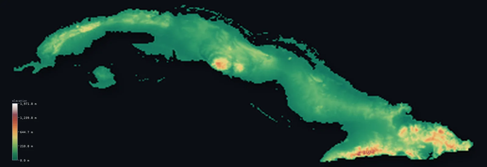
Cuba’s highest point is Pico Turquino at 6,476 ft (1,974 m); its lowest is Caribbean Sea at 0 ft (0 m); the mean elevation is 320 ft (97.6 m).
Cuba is the largest island in the Caribbean, and most of it is low — gentle limestone plains and low hills, with about 88% of the country lying below 656 ft (200 m). The one real exception is the southeast, where the Sierra Maestra rises abruptly along the coast to Pico Turquino at 6,476 ft (1,974 m), the island's only mountain country. The rest is a long, low, fertile land of sugar, tobacco, and karst.
- Highest point📚
- 6,476 ft1,974 m
- Cuba's highest point is Pico Turquino at 6,476 ft (1,974 m), in the Sierra Maestra along the southeastern coast — a steep coastal range that is the island's only true mountains, rising almost directly from the Caribbean shore.
- Lowest point📚
- 0 ft0 m
- Cuba's lowest point is the sea at sea level, around a long coastline of beaches, coral reef, and mangrove — fitting for a low island whose interior rarely rises far above it.
- Mean elevation⚙
- 320 ft97.6 m
- Computed from the GLO-30 model, Cuba's mean elevation is 320 ft (97.6 m) — very low, as befits a large island that is mostly plain and low hill, with its only mountains confined to the southeastern corner.
- Median elevation⚙
- 158 ft48.2 m
- Half of Cuba lies below 158 ft (48 m) — a very low median, and the plainest statement of the island's form: the great majority is low limestone plain and gentle hill country, with the Sierra Maestra a small, steep exception in the southeast.
- Elevation range📚
- 6,476 ft1,974 m
- From the sea to the summit of Pico Turquino, Cuba spans about 6,480 ft — but almost all of it is gained in the Sierra Maestra of the southeast; across the rest of the long island, the land stays low.
- Above 50 m (164 ft)⚙
- 49%
- About 49% of Cuba rises above 164 ft (50 m) — and not much higher: the island is low limestone plain and gentle hill, with only the Sierra Maestra in the southeast climbing above 1,000 m.
- Official area📚
- 42,426 mi²109,884 km²
- Cuba covers about 42,400 sq mi (109,884 sq km) — the largest island in the Caribbean, a long, narrow landmass stretching east to west across the mouth of the Gulf of Mexico, plus thousands of smaller cays.
- Forest cover📚
- 30.7%
- About 30.7% of Cuba is forested — regrown across much of the island, with pine and rainforest in the mountains of the east and mangrove along the coasts, amid the farmland of sugar and tobacco.
Highest and lowest points
Cuba's highest point is Pico Turquino, 6,476 ft (1,974 m), in the Sierra Maestra along the southeastern coast. The range rises sharply and directly from the Caribbean — the island's only genuine mountain country — and Turquino's forested summit carries a bust of José Martí. Though Cuba is the largest island in the Caribbean, it is not the highest: the mountains of Hispaniola, next door, rise well above it. The Sierra Maestra is a place apart from the low limestone plains that make up most of the country.
source ↗Cuba's lowest point is the sea at sea level, around a coastline more than 5,000 km long counting its bays and inlets — beaches, coral reef, mangrove swamp, and the flat cays that fringe the main island. Beyond the shore, Cuba's interior is mostly a low limestone platform, so the transition from sea to land is gentle almost everywhere except the southeastern mountains, where the Sierra Maestra meets the water steeply.
source ↗Cuba at a glance
Cuba is the largest island in the Caribbean, but not the highest — Hispaniola's mountains rise well above Cuba's Pico Turquino (1,974 m).
source ↗About 88% of Cuba lies below 200 m — the island is overwhelmingly low limestone plain and gentle hill.
source ↗Cuba's only true mountains, the Sierra Maestra, rise abruptly along the southeastern coast, carrying Pico Turquino directly above the Caribbean.
source ↗Much of Cuba is karst — limestone country of caves, sinkholes, and the distinctive steep-sided mogotes of the Viñales valley in the west.
source ↗Cuba is fringed by thousands of small cays and islets, and its second-largest island, the Isla de la Juventud, lies off the southwestern coast.
source ↗Cuba's largest wetland, the Zapata Swamp on the south coast, covers more than 4,520 km² — bigger than many small countries.
source ↗
Elevation profile of Cuba
The largest share of land, 88%, falls in the 0–200 m band, and 96% of the territory lies below 500 m (1,640 ft).
- 0–10 m (0–33 ft)22%
- 10–50 m (33–164 ft)29%
- above 50 m (164 ft)49%
Highest peaks of Cuba
| Peak | Elevation | Range | Note |
|---|---|---|---|
| Pico Turquino↗ | 6,476 ft1,974 m | Sierra Maestra | Highest point of Cuba, in the steep Sierra Maestra along the southeastern coast. |
| Pico Bayamesa↗ | 5,676 ft1,730 m | Sierra Maestra | One of the highest summits of the Sierra Maestra, west of Turquino. |
| Pico Cristal↗ | 4,039 ft1,231 m | Sierra Cristal / Nipe (southeast) | A high point of the Sierra Cristal in the southeast, site of Cuba's first national park (1930). |
| Pico San Juan↗ | 3,740 ft1,140 m | Escambray (Guamuhaya), central Cuba | The highest peak of the Escambray Mountains in central Cuba, near Trinidad. |
| Pan de Guajaibón↗ | 2,270 ft692 m | Sierra del Rosario (northwest) | The high point of the northwestern sierras (Guaniguanico), in the limestone country of Pinar del Río. |
The low limestone island and its one mountain range
The western and central lowlands
Most of Cuba — a long belt of low limestone plain and gentle hill running the length of the island, from the tobacco country and the mogotes of Viñales in the west through the great sugar plains of the centre. Fertile, low, and karst-riddled, this is the overwhelming bulk of the country.
The Sierra Maestra and the southeast
In the southeast the Sierra Maestra rises steeply from the Caribbean coast to Pico Turquino, the island's high point — a compact, forested range that is Cuba's only true mountain country, holding the city of Santiago de Cuba at its foot.
The Escambray and the coasts
Smaller upland groups punctuate the lowlands — notably the Escambray in the south-centre — while around the whole island run the coasts and their thousands of cays: reef, mangrove, and low sandy islets fringing the main landmass.
How to read this map
Color shows elevation; the raised relief shows real terrain. On this map Cuba reads as a long, low green island, gently hilly along its length, with a single concentration of brown-and-white mountains at the southeastern end — the Sierra Maestra above Santiago.
The 3D relief is the actual GLO-30 elevation data, exaggerated vertically so the low hills and the southeastern mountains both show; the ×N relief slider controls how much. Tap anywhere to read that point's exact elevation.
City elevations in Cuba
Cuba's cities line the coasts and the central plain — Havana in the northwest, Santiago de Cuba beneath the Sierra Maestra in the southeast, the others (Camagüey, Holguín, Santa Clara) across the low interior. Nearly all sit low, on plain or coast.
| City | Population | Elevation |
|---|---|---|
| Havanacapitalthe capital, on the northwestern coast, Cuba's largest city and main port ↗ | 2,163,824 | 121 ft37 m |
| Santiago de Cubain the southeast at the foot of the Sierra Maestra, the island's second city ↗ | 555,865 | 184 ft56 m |
| Camagüey | 347,562 | 328 ft100 m |
| Holguín | 319,102 | 463 ft141 m |
| Santa Clara | 250,512 | 417 ft127 m |
| Pinar del Río | 186,990 | 171 ft52 m |
| Matanzas | 146,733 | 23 ft7 m |
| Ciego de Ávila | 142,027 | 161 ft49 m |
| Manzanillo | 128,188 | 79 ft24 m |
| Moa | 92,852 | 92 ft28 m |
Elevation sampled at each city centre from the Copernicus GLO-30 model. Cities and population from GeoNames (CC-BY 4.0).
Cuba in comparison
Cuba's terrain rises 6,476 ft (1,974 m) from sea level to Pico Turquino — about 22% of the height of Mount Everest, the world's highest point at 29,032 ft (8,849 m).
- Jamaica's mean elevation is 1,050 ft — 730 ft higher; its high point, Blue Mountain Peak, reaches 7,402 ft (2,256 m), 925 ft above. Jamaica elevation map →
- Dominican Republic's mean elevation is 1,309 ft — 989 ft higher; its high point, Pico Duarte, reaches 10,164 ft (3,098 m), 3,688 ft above. Dominican Republic elevation map →
- Haiti's mean elevation is 1,332 ft — 1,012 ft higher; its high point, Pic la Selle, reaches 8,793 ft (2,680 m), 2,316 ft above. Haiti elevation map →
Frequently asked questions
What is the highest point in Cuba?
- Pico Turquino, 6,476 ft (1,974 m), in the Sierra Maestra along the southeastern coast — the island's only true mountains.
What is the lowest point in Cuba?
- The sea at sea level, around a long coastline of beaches, reef, and mangrove.
What is the average elevation of Cuba?
- Computed from the Copernicus GLO-30 model, the area-weighted mean is 320 ft (97.6 m) — very low, because the island is mostly limestone plain and hill, with mountains only in the southeast.
Is Cuba flat?
- Largely — about 88% lies below 200 m, low limestone plain and gentle hill. Its only real mountains, the Sierra Maestra, rise in the southeast to Pico Turquino.
Is Cuba the highest island in the Caribbean?
- No — it is the largest, but not the highest. The mountains of neighbouring Hispaniola rise well above Cuba's Pico Turquino.
Is this a topographic, relief, contour, or elevation map of Cuba?
- They describe the same thing — terrain height. This page renders the country's actual elevation surface in interactive 3D and reports the statistics computed from it.
About this map
The terrain is rendered from the Copernicus GLO-30 digital elevation model (ESA), masked to the CUB-ADM0 boundary from geoBoundaries (gbOpen). Elevation statistics are computed directly from the model; peak names and researched facts are sourced and cited. See the methodology for the full pipeline.
Our area-weighted mean, computed from the Copernicus GLO-30 model, is 320 ft (97.6 m); the figure commonly cited elsewhere is 354 ft (108 m) (CIA World Factbook). About two-thirds of Cuba is flat to rolling plain, with mountains covering only about a quarter of the island, mostly in the southeast — so the mean elevation is low; the page reports the area-weighted figure computed from the Copernicus GLO-30 model.
Surveyed national figures: official area · forest cover · high point.
Rendered from Copernicus GLO-30 (ESA, 2021 release), boundaries from geoBoundaries. Generated 2026-06-22.