Haiti Elevation Map
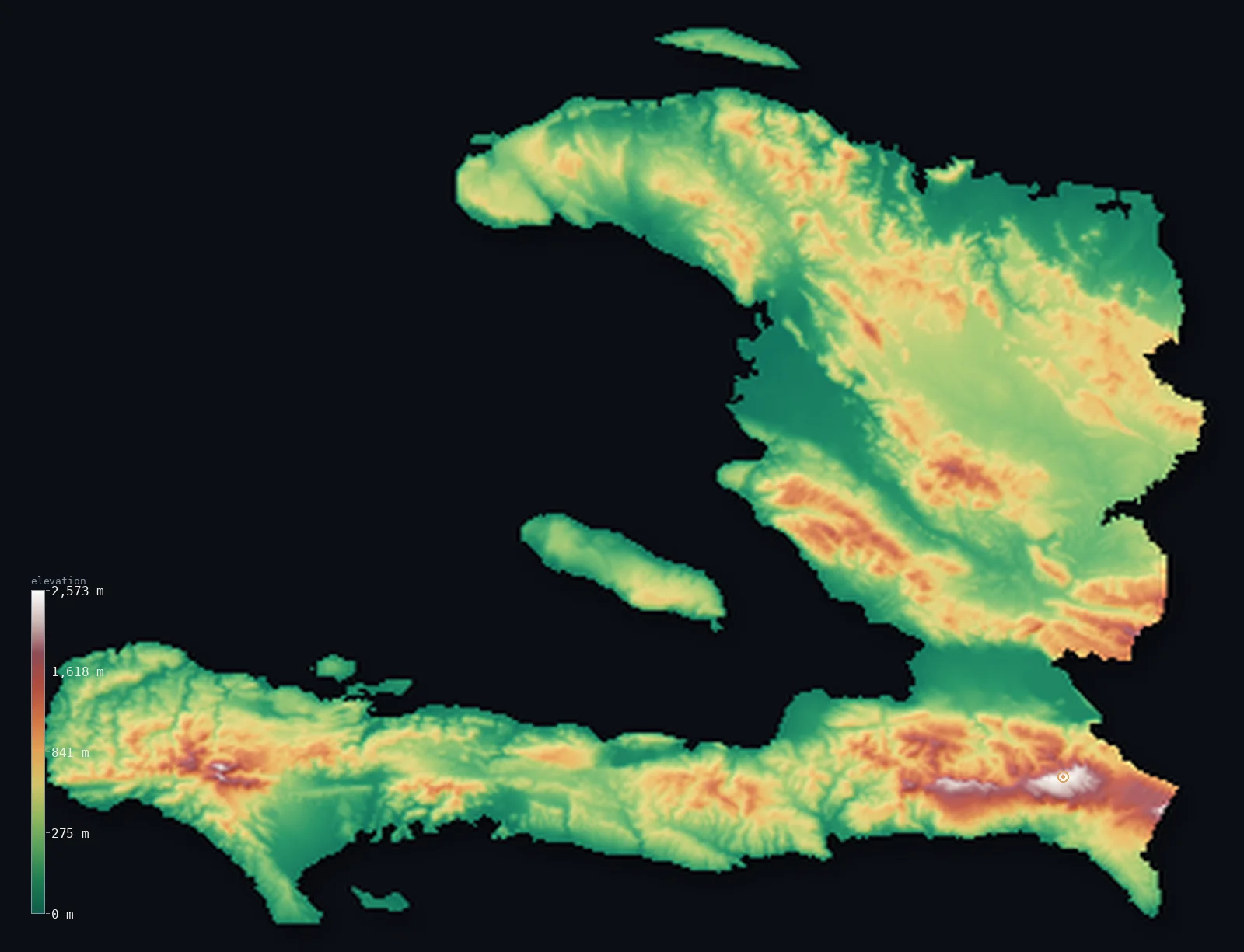
Haiti’s highest point is Pic la Selle at 8,793 ft (2,680 m); its lowest is Caribbean Sea at 0 ft (0 m); the mean elevation is 1,332 ft (406 m).
- Highest point📚
- 8,793 ft2,680 m
- Pic la Selle, in the southeastern Massif de la Selle.
- Lowest point📚
- 0 ft0 m
- Sea level along the Caribbean and Atlantic coasts.
- Mean elevation⚙
- 1,332 ft406 m
- Computed from the GLO-30 surface model across the whole country.
- Median elevation⚙
- 1,037 ft316 m
- Half of Haiti lies below this height.
- Elevation range📚
- 8,793 ft2,680 m
- From the sea to Pic la Selle's ~2,680 m.
- Above 1,000 m (3,281 ft)⚙
- 7%
- The Massif de la Selle and the Massif de la Hotte of the southern peninsula.
- Official area📚
- 10,714 mi²27,750 km²
- A rugged country occupying the western third of Hispaniola.
- Forest cover📚
- 3.5%
- Only a small fraction is forest now, after heavy deforestation.
Highest and lowest points
The highest point of Haiti at about 2,680 m - Pic la Selle, in the Massif de la Selle (Chaine de la Selle) of the southeastern peninsula. It lies near, but inside, the Dominican border; the range continues east into the Dominican Republic as the lower Sierra de Bahoruco. Britannica gives 2,674 m.
source ↗Haiti at a glance
Haiti's name comes from the Taino word 'Ayiti', meaning 'land of mountains' - and the country lives up to it, with rugged ranges across most of its territory.
source ↗Pic la Selle (2,680 m) is Haiti's high point and the highest peak in the Caribbean outside the Dominican Republic, sitting just inside the Dominican border.
source ↗Haiti shares the island of Hispaniola with the Dominican Republic, occupying the western third; the same mountain chains cross the border between them.
source ↗The Plaine du Cul-de-Sac near Port-au-Prince is a low depression holding saline lakes - part of the same rift that, just across the border, drops to Lake Enriquillo well below sea level.
source ↗Once heavily forested, Haiti now has only a small fraction of forest cover left, the result of long and severe deforestation.
source ↗The Artibonite, Haiti's largest river, rises in the Dominican Republic and flows across the country to the Gulf of Gonave, watering its most important farmland.
source ↗
Elevation profile of Haiti
The largest share of land, 34%, falls in the 0–200 m band, and 69% of the territory lies below 500 m (1,640 ft).
- below 500 m (1,640 ft)69%
- 500–1,000 m24%
- 1,000–2,000 m7%
- above 2,000 m (6,562 ft)<1%
Highest peaks of Haiti
| Peak | Elevation | Range | Note |
|---|---|---|---|
| Pic la Selle↗ | 8,793 ft2,680 m | Massif de la Selle (southeast) | Highest point of Haiti, in the southeastern Massif de la Selle near the Dominican border. |
| Pic Macaya↗ | 7,700 ft2,347 m | Massif de la Hotte (southwest) | The second-highest peak, crowning the Massif de la Hotte at the western tip of the southern peninsula. |
| Morne la Visite↗ | 7,119 ft2,170 m | Massif de la Selle (southeast) | A high point of the La Visite plateau in the Massif de la Selle, within a national park. |
Terrain regions of Haiti
Haiti's name comes from the Taino word 'Ayiti', meaning 'land of mountains' - and the country lives up to it, with rugged ranges across most of its territory. ↗
The northern region
↗The northern peninsula and the Plaine du Nord coastal plain along the Atlantic, backed by the Massif du Nord - the western continuation of the Dominican Republic's Cordillera Central.
The central region
↗The interior - the Plateau Central, the Montagnes Noires and Chaine des Matheux, and the broad Artibonite plain, drained by the Artibonite, Haiti's largest river, to the Gulf of Gonave.
The southern peninsula
↗The long Tiburon Peninsula - the Massif de la Selle in the east (with Pic la Selle, 2,680 m) and the Massif de la Hotte in the west (with Pic Macaya), plus the low Cul-de-Sac depression and its saline lakes near Port-au-Prince.
The southern peninsula and its massifs
the southern peninsulaHaiti's highest ground runs along the southern (Tiburon) peninsula. In the southeast, the Massif de la Selle rises to Pic la Selle (2,680 m), the country's summit, continuing east into the Dominican Republic as the Sierra de Bahoruco. Westward, the chain becomes the Massif de la Hotte, crowned by Pic Macaya (2,347 m). Between the peninsula and the mainland lies the low Plaine du Cul-de-Sac, a depression holding the saline Lake Azuei.
The central ranges and the Artibonite
the centreThe interior is a maze of mountains - the Plateau Central, the Montagnes Noires, and the Chaine des Matheux - that block east-west travel and feed the Artibonite River, whose broad valley is Haiti's largest and most productive farmland, draining to the Gulf of Gonave.
The north and the coasts
the north and coastal fringeIn the north, the Massif du Nord - the continuation of the Dominican Cordillera Central - runs behind the Atlantic coastal Plaine du Nord around Cap-Haitien. Narrow coastal plains ring much of the country, and several islands, chiefly Ile de la Gonave in the gulf of the same name, lie offshore.
City elevations in Haiti
| City | Population | Elevation |
|---|---|---|
| Port-au-PrincecapitalPort-au-Prince, the capital, sits on the Plaine du Cul-de-Sac at the head of the Gulf of Gonave, a lowland depression holding the saline Lake Azuei. ↗ | 1,234,742 | 69 ft21 m |
| Port-de-Paix | 306,217 | 20 ft6 m |
| Saint-Marc | 266,642 | 20 ft6 m |
| Dessalines | 181,903 | 72 ft22 m |
| Jacmel | 137,966 | 62 ft19 m |
| Cap-Haïtien | 134,815 | 16 ft5 m |
| Léogâne | 134,190 | 49 ft15 m |
| Arcahaie | 130,306 | 33 ft10 m |
| Les Cayes | 125,799 | 16 ft5 m |
| Tigwav | 117,504 | 39 ft12 m |
Elevation sampled at each city centre from the Copernicus GLO-30 model. Cities and population from GeoNames (CC-BY 4.0).
Haiti in comparison
Haiti's terrain rises 8,793 ft (2,680 m) from sea level to Pic la Selle — about 30% of the height of Mount Everest, the world's highest point at 29,032 ft (8,849 m).
- Dominican Republic's mean elevation is 1,309 ft — 23 ft lower; its high point, Pico Duarte, reaches 10,164 ft (3,098 m), 1,371 ft above. Dominican Republic elevation map →
- Jamaica's mean elevation is 1,050 ft — 282 ft lower; its high point, Blue Mountain Peak, reaches 7,402 ft (2,256 m), 1,391 ft below. Jamaica elevation map →
- Cuba's mean elevation is 320 ft — 1,012 ft lower; its high point, Pico Turquino, reaches 6,476 ft (1,974 m), 2,316 ft below. Cuba elevation map →
Frequently asked questions
What is the highest point in Haiti?
- Pic la Selle, about 8,793 ft (2,680 m), in the Massif de la Selle of the southeastern peninsula - the highest peak in the Caribbean outside the Dominican Republic.
Is Pic la Selle on the border with the Dominican Republic?
- It lies just inside Haiti, close to the border; the same range continues east into the Dominican Republic as the lower Sierra de Bahoruco.
What is the average elevation of Haiti?
- Computed from the Copernicus GLO-30 model, the area-weighted mean is 1,332 ft (406 m). Haiti is largely mountainous, so the mean is fairly high.
What is the lowest point in Haiti?
- Sea level, along its Caribbean and Atlantic coasts.
Does Haiti share its island?
- Yes - Haiti occupies the western third of Hispaniola, and the Dominican Republic the eastern two-thirds; the mountain ranges cross between them.
Where are the mountains in Haiti?
- Across most of the country - chiefly the Massif de la Selle and Massif de la Hotte on the southern peninsula, the central ranges, and the Massif du Nord.
Is this a topographic, relief, contour, or elevation map of Haiti?
- They describe the same thing - terrain height. This page renders Haiti's actual elevation surface in interactive 3D (a relief or topographic view) and reports the elevation statistics computed from it; a contour map shows the same data as lines of equal height.
About this map
The terrain is rendered from the Copernicus GLO-30 digital elevation model (ESA), masked to the HTI-ADM0 boundary from geoBoundaries (gbOpen). Elevation statistics are computed directly from the model; peak names and researched facts are sourced and cited. See the methodology for the full pipeline.
Our area-weighted mean, computed from the Copernicus GLO-30 model, is 1,332 ft (406 m); the figure commonly cited elsewhere is 1,542 ft (470 m) (CIA World Factbook). Haiti is famously mountainous - its name comes from a Taino word for 'land of mountains' - with rugged ranges across most of the country and only narrow coastal plains and a few interior valleys, giving a fairly high mean elevation; the page reports the area-weighted figure computed from the Copernicus GLO-30 model.
Surveyed national figures: official area · forest cover · high point.
Rendered from Copernicus GLO-30 (ESA, 2021 release), boundaries from geoBoundaries. Generated 2026-06-23.
Bordering countries · 1
Haiti shares a land border with these countries — open any one to compare its terrain and highest point.