Jamaica Elevation Map — Topographic & 3D Terrain
Explore the terrain of Jamaica in interactive 3D, built from Copernicus GLO-30 satellite elevation data — a mountainous Caribbean island rising from coastal plains to the Blue Mountains. Drag to rotate, scroll to zoom, and tap any point to read its elevation.
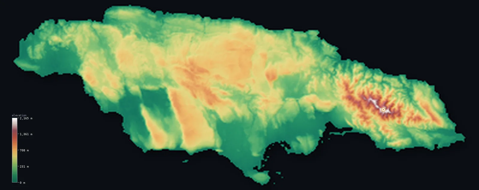
Jamaica’s highest point is Blue Mountain Peak at 7,402 ft (2,256 m); its lowest is Caribbean Sea at 0 ft (0 m); the mean elevation is 1,050 ft (320 m).
Jamaica is a mountainous Caribbean island — the third-largest in the Caribbean, and one of the highest. A mountainous spine runs the length of it, rising in the east to the Blue Mountains, whose summit, Blue Mountain Peak, reaches 7,402 ft (2,256 m), the highest point in Jamaica and the highest of any island in the Caribbean outside Hispaniola. West of the mountains lies a broad limestone plateau, much of it the strange, pitted karst of the Cockpit Country, and around the edges run coastal plains where most Jamaicans live and where the resort coasts lie. It is a green, rugged island: though the mountains and hills dominate, about half the country lies below about 870 ft — in the coastal plains and the lower valleys.
- Highest point📚
- 7,402 ft2,256 m
- Jamaica's highest point is Blue Mountain Peak at 7,402 ft (2,256 m), in the Blue Mountains of the island's east — the highest peak in Jamaica, and the highest on any Caribbean island outside Hispaniola (where the Dominican Republic's Pico Duarte and Haiti's summits stand higher). The Blue Mountains rise steeply and close to the sea, so that from their misty, forest-clad summit — famous for its coffee and, on a clear dawn, a view that is said to reach Cuba — the land falls fast to the coast.
- Lowest point📚
- 0 ft0 m
- Jamaica's lowest point is the Caribbean Sea at sea level, around the island's coasts — the low coastal plains, most extensive in the south around the capital, Kingston, and along the resort shores of the north. From these coastal lowlands the land rises quickly inland to the mountains and the high limestone plateau.
- Mean elevation⚙
- 1,050 ft320 m
- Computed from the GLO-30 model, Jamaica's mean elevation is 1,050 ft (320 m) — lifted by the island's mountains and high limestone plateau, though about half of Jamaica lies below about 873 ft (266 m): the coastal plains and lower valleys around the edges are low, while the Blue Mountains in the east and the interior plateau, rugged and high, raise the average above the typical point.
- Median elevation⚙
- 873 ft266 m
- Half of Jamaica lies below about 873 ft (266 m) — because, though the island is mountainous, its high ground is concentrated in the Blue Mountains of the east and the interior limestone plateau, while broad coastal plains and lower valleys ring the island. The mountains are high, but the low coastal margins hold much of the land and most of the people.
- Elevation range📚
- 7,402 ft2,256 m
- From the sea to the summit of Blue Mountain Peak at 2,256 m, Jamaica's terrain climbs about 7,402 ft — a great range for so small an island, from tropical coastal plains up to the highest island summit in the Caribbean outside Hispaniola, all within a short distance of the sea.
- Above 1,000 m (3,281 ft)⚙
- 2%
- About 2% of Jamaica rises above 1,000 m (3,281 ft) — chiefly the Blue Mountains in the east, the island's highest ground, with the John Crow Mountains beside them. The coastal plains and the lower interior lie well below.
- Official area📚
- 4,244 mi²10,991 km²
- Jamaica covers about 4,244 sq mi (10,991 sq km) — the third-largest island in the Caribbean, a mountainous land of the Blue Mountains in the east (holding Blue Mountain Peak, the highest island summit in the Caribbean outside Hispaniola), a broad interior limestone plateau (the karst Cockpit Country), and coastal plains around the edges.
- Forest cover📚
- 31%
- About 31% of Jamaica is forested — rainforest and cloud forest on the high, wet Blue Mountains and John Crow Mountains, drier woodland on the limestone plateau, and much of the coastal lowland cleared for farming, towns, and resorts.
Highest and lowest points
Jamaica's highest point is Blue Mountain Peak, 7,402 ft (2,256 m), in the Blue Mountains at the eastern end of the island. The Blue Mountains are a steep, high range rising close to the sea, cloaked in misty rainforest and cloud forest, and famous for the Blue Mountain coffee grown on their slopes; from the summit, on a clear dawn, it is said one can see across the sea to Cuba. Blue Mountain Peak is the highest point in Jamaica — and the highest summit of any Caribbean island except Hispaniola, whose greater mountains (the Dominican Republic's Pico Duarte and the peaks of Haiti) stand higher. Beside the Blue Mountains rise the wet John Crow Mountains, and west across the island stretches the high limestone plateau of the interior. So Jamaica's roof is its steep eastern range, rising from coast to summit in a short, dramatic sweep.
source ↗Jamaica's lowest point is the Caribbean Sea at sea level, and around the island's edges run coastal plains — broadest in the south, where the capital, Kingston, sits on a great natural harbour, and along the north coast, the resort shore of Montego Bay and Ocho Rios. But Jamaica is mostly high ground: from these coastal lowlands the land rises quickly. In the east stand the Blue Mountains, a steep, high, forest-clad range holding Blue Mountain Peak (2,256 m, the highest point in Jamaica and the highest island summit in the Caribbean outside Hispaniola) and, beside them, the wet John Crow Mountains. West of the mountains, most of the interior is a high limestone plateau — a rugged, pitted karst landscape, most dramatically in the Cockpit Country, a maze of steep conical hills and sinkholes that long sheltered the free Maroon communities. So the island rises from low coasts to a high, rough interior, and Jamaica's terrain is that of mountains and plateau far more than plains.
source ↗Jamaica at a glance
Jamaica's Blue Mountain Peak (2,256 m) is the highest summit of any Caribbean island outside Hispaniola - higher than any point on Cuba, Puerto Rico, or the rest of the Antilles.
source ↗The Blue Mountains rise steeply close to the sea - from the summit, on a clear dawn, it is said one can see across the water to Cuba.
source ↗Much of interior Jamaica is a high limestone plateau - including the Cockpit Country, a maze of steep conical karst hills and sinkholes that long sheltered the free Maroon communities.
source ↗World-famous Blue Mountain coffee is grown on the high, misty slopes of Jamaica's eastern mountains.
source ↗Jamaica is the third-largest island in the Caribbean - a mountainous land where the high ground rises quickly from coastal plains to the Blue Mountains and the interior plateau.
source ↗Though mountainous, about half of Jamaica lies low - in the coastal plains and valleys around the island's edges, where most of the population lives.
source ↗
Elevation profile of Jamaica
The largest share of land, 41%, falls in the 0–200 m band, and 75% of the territory lies below 500 m (1,640 ft).
- below 500 m (1,640 ft)75%
- 500–1,000 m23%
- 1,000–2,000 m2%
- above 2,000 m (6,562 ft)<1%
Highest peaks of Jamaica
| Peak | Elevation | Range | Note |
|---|---|---|---|
| Blue Mountain Peak↗ | 7,402 ft2,256 m | Blue Mountains (east) | Highest point of Jamaica and the highest peak in the Caribbean outside Hispaniola. |
| Catherine's Peak↗ | 5,059 ft1,542 m | Blue Mountains (east) | A prominent peak above Newcastle in the western Blue Mountains, near Kingston. |
| John Crow Mountains (high point)↗ | 3,740 ft1,140 m | John Crow Mountains (east) | A rugged limestone ridge east of the Blue Mountains, sharing the Blue and John Crow Mountains National Park. |
Jamaica: the Blue Mountains, the limestone plateau, and the coastal plains
The Blue Mountains and John Crow Mountains — the east
At the island's eastern end rise the Blue Mountains — a steep, high, forest-clad range holding Blue Mountain Peak (the high point and the Caribbean's highest island summit outside Hispaniola), with the wet John Crow Mountains beside them. Jamaica's highest, steepest, wettest ground.
The interior limestone plateau — the Cockpit Country
Most of the interior west of the mountains is a high limestone plateau — rugged karst country of conical hills, sinkholes, and caves, most dramatically the Cockpit Country. The island's rough, high, hollow heart.
The coastal plains
Around the island's edges run coastal plains — broadest in the south around Kingston and along the northern resort coast — low, warm, and holding most of the population. The island's low, populous rim.
How to read this map
Color shows elevation; the raised relief shows real terrain. On this map Jamaica reads as a high island rising from a low rim — the browns of the Blue Mountains standing sharply at the eastern end (highest at Blue Mountain Peak), the broad mid-tone of the high limestone plateau (the pitted Cockpit Country) filling much of the interior, and the low green of the coastal plains around the edges, widest in the south.
The 3D relief is the actual GLO-30 elevation data, exaggerated vertically so the eastern mountains and the low coasts both show; the ×N relief slider controls how much. Tap anywhere to read that point's exact elevation.
City elevations in Jamaica
Jamaica's cities lie mostly on the coasts — Kingston, the capital, on its great southern harbour, with Montego Bay on the northern resort coast and Spanish Town and May Pen on the southern plain. A few, like Mandeville, sit inland on the high limestone plateau. Most Jamaicans live low, on the coastal edges, below the mountainous interior.
| City | Population | Elevation |
|---|---|---|
| Kingstoncapitalthe capital, on the southern coast's great harbour, below the Blue Mountains ↗ | 937,700 | 203 ft62 m |
| Spanish Townon the southern plain, west of Kingston ↗ | 145,018 | 98 ft30 m |
| Montego Bayon the north coast ↗ | 82,867 | 39 ft12 m |
| Mandevilleinland, high on the interior limestone plateau ↗ | 47,115 | 2,011 ft613 m |
| May Penon the southern plain ↗ | 44,755 | 256 ft78 m |
| Linsteadin the interior, north of Spanish Town ↗ | 20,660 | 384 ft117 m |
| Savanna-la-Maron the southwest coast ↗ | 16,553 | 16 ft5 m |
| Port Antonioon the northeast coast, below the John Crow Mountains ↗ | 14,400 | 13 ft4 m |
| Saint Ann’s Bayon the north coast ↗ | 13,671 | 72 ft22 m |
| Barbican | 10,337 | 39 ft12 m |
Elevation sampled at each city centre from the Copernicus GLO-30 model. Cities and population from GeoNames (CC-BY 4.0).
Jamaica in comparison
Jamaica's terrain rises 7,402 ft (2,256 m) from sea level to Blue Mountain Peak — about 25% of the height of Mount Everest, the world's highest point at 29,032 ft (8,849 m).
- Cuba's mean elevation is 320 ft — 730 ft lower; its high point, Pico Turquino, reaches 6,476 ft (1,974 m), 925 ft below. Cuba elevation map →
- Dominican Republic's mean elevation is 1,309 ft — 259 ft higher; its high point, Pico Duarte, reaches 10,164 ft (3,098 m), 2,762 ft above. Dominican Republic elevation map →
- Haiti's mean elevation is 1,332 ft — 282 ft higher; its high point, Pic la Selle, reaches 8,793 ft (2,680 m), 1,391 ft above. Haiti elevation map →
Frequently asked questions
What is the highest point in Jamaica?
- Blue Mountain Peak, 7,402 ft (2,256 m), in the eastern Blue Mountains - the highest point in Jamaica and the highest summit of any Caribbean island outside Hispaniola.
What is the lowest point in Jamaica?
- The Caribbean Sea at sea level, around the coasts - the low coastal plains, broadest in the south around Kingston.
What is the average elevation of Jamaica?
- Computed from the Copernicus GLO-30 model, the area-weighted mean is 1,050 ft (320 m) - lifted by the mountains and the high limestone plateau; about half of Jamaica lies below about 873 ft (266 m), in the coastal plains and lower valleys.
What is the highest mountain in the Caribbean outside Hispaniola?
- Blue Mountain Peak in Jamaica, at 7,402 ft (2,256 m) - higher than any point on Cuba, Puerto Rico, or the rest of the Antilles, though lower than Hispaniola's peaks (the Dominican Republic's Pico Duarte and Haiti's summits).
What is the Cockpit Country?
- A rugged high limestone plateau in interior Jamaica - a maze of steep conical karst hills and sinkholes that long sheltered the island's free Maroon communities.
Is this a topographic, relief, contour, or elevation map of Jamaica?
- They describe the same thing - terrain height. This page renders the island's actual elevation surface in interactive 3D and reports the statistics computed from it.
About this map
The terrain is rendered from the Copernicus GLO-30 digital elevation model (ESA), masked to the JAM-ADM0 boundary from geoBoundaries (gbOpen). Elevation statistics are computed directly from the model; peak names and researched facts are sourced and cited. See the methodology for the full pipeline.
Our area-weighted mean, computed from the Copernicus GLO-30 model, is 1,050 ft (320 m); no authority publishes a mean elevation (no authoritative published mean). Jamaica is a mountainous island, but its heights are gathered at one end. The Blue Mountains rise steeply in the east, holding Blue Mountain Peak — the highest island summit in the Caribbean outside Hispaniola — and behind them stretches a high interior limestone plateau, the pitted karst of the Cockpit Country. But around the whole island run coastal plains, low and warm, where most Jamaicans live; and these lowlands, with the lower valleys, hold about half the land, so half of Jamaica lies below about 873 ft (266 m). In Jamaica, height is an eastern affair — the Blue Mountains and the plateau behind them hold nearly all of it, while the populous coasts stay low.
Surveyed national figures: official area · forest cover · high point.
Rendered from Copernicus GLO-30 (ESA, 2021 release), boundaries from geoBoundaries. Generated 2026-06-23.