Dominican Republic Elevation Map — Topographic & 3D Terrain
Explore the terrain of the Dominican Republic in interactive 3D, built from Copernicus GLO-30 satellite elevation data — the mountainous eastern two-thirds of Hispaniola, from the Caribbean's highest peak to a below-sea salt lake. Drag to rotate, scroll to zoom, and tap any point to read its elevation.
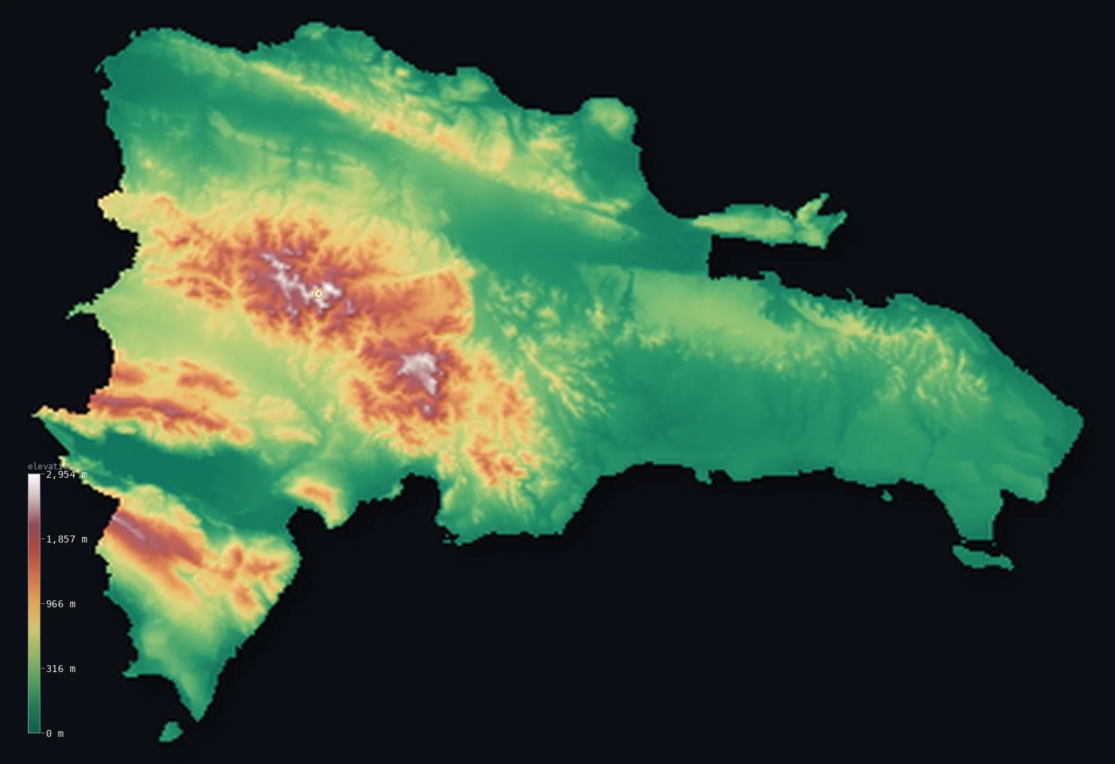
Dominican Republic’s highest point is Pico Duarte at 10,164 ft (3,098 m); its lowest is Lago Enriquillo at −151 ft (−46 m); the mean elevation is 1,309 ft (399 m).
The Dominican Republic occupies the eastern two-thirds of Hispaniola, the second-largest island in the Caribbean, which it shares with Haiti. It is a country of high mountains and broad valleys: several ranges cross it, above all the Cordillera Central, the great spine of the island, which rises to Pico Duarte at 10,164 ft (3,098 m) — the highest point not just in the Dominican Republic but in the entire Caribbean. Yet between and around the mountains lie wide lowlands — the fertile Cibao Valley, the eastern coastal plains, and, in the southwest, the Enriquillo Basin, which drops below sea level to a great salt lake. So while the ranges are high, about half the country lies below about 640 ft, in the valleys and coastal plains.
- Highest point📚
- 10,164 ft3,098 m
- The Dominican Republic's highest point is Pico Duarte at 10,164 ft (3,098 m), in the Cordillera Central — the great mountain spine of Hispaniola — and the highest peak in the entire Caribbean, higher than any mountain on Cuba, Jamaica, Puerto Rico, or elsewhere in the Antilles. It rises in a rugged, forested massif in the heart of the country, high above the surrounding valleys, its summit cool enough for frost.
- Lowest point📚
- −151 ft−46 m
- The Dominican Republic's lowest point is Lago Enriquillo, a large salt lake in the southwestern Enriquillo Basin, whose surface lies about 151 ft (46 m) below sea level — the lowest point in the entire Caribbean. This hypersaline lake, set in a hot, dry rift basin below the level of the sea, is a remnant of an ancient marine strait that once cut Hispaniola in two.
- Mean elevation⚙
- 1,309 ft399 m
- Computed from the GLO-30 model, the Dominican Republic's mean elevation is 1,309 ft (399 m) — a middling figure for a country of extremes, holding both the Caribbean's highest summit and its lowest, below-sea basin. Between those poles the land is mostly valley and plain, so the median sits at 636 ft (194 m), well below the mean.
- Median elevation⚙
- 636 ft194 m
- Half of the Dominican Republic lies below about 636 ft (194 m) — because the country's high ranges, though they reach the Caribbean's highest summit, are separated by wide lowlands: the fertile Cibao Valley in the north, the coastal plains in the east and south, and the below-sea Enriquillo Basin. The mountains are high, but the valleys and plains hold much of the land.
- Elevation range📚
- 10,315 ft3,144 m
- From the below-sea shore of Lago Enriquillo to the summit of Pico Duarte at 3,098 m, the Dominican Republic's terrain spans about 10,315 ft — a remarkable range for an island country, from the lowest point in the Caribbean to the highest, both within this one nation on Hispaniola.
- Above 1,000 m (3,281 ft)⚙
- 13%
- About 13% of the Dominican Republic rises above 1,000 m (3,281 ft) — the higher parts of the Cordillera Central and the other ranges; even 500 m (1,640 ft) is cleared by only 28% of the country. The Cibao Valley, the coastal plains, and the Enriquillo Basin lie below.
- Above 2,000 m (6,562 ft)⚙
- 1%
- Roughly 1% of the Dominican Republic stands above 2,000 m (6,562 ft) — the highest ground of the Cordillera Central around Pico Duarte, the Caribbean's roof.
- Official area📚
- 18,792 mi²48,671 km²
- The Dominican Republic covers about 18,800 sq mi (48,671 sq km) — the eastern two-thirds of Hispaniola, shared with Haiti: a mountainous country of several ranges (the Cordillera Central holding Pico Duarte, the Caribbean's highest peak) divided by broad valleys and coastal plains, with the below-sea Enriquillo Basin in the southwest.
- Forest cover📚
- 43.4%
- About 43% of the Dominican Republic is forested — pine forest on the high slopes of the Cordillera Central, tropical and moist forest on the wetter mountain sides and the east, and drier woodland and scrub in the rain-shadowed southwest around the Enriquillo Basin.
Highest and lowest points
The Dominican Republic's highest point is Pico Duarte, 10,164 ft (3,098 m), in the Cordillera Central — and the highest mountain in the entire Caribbean, higher than any peak in Cuba, Jamaica, Puerto Rico, or anywhere else in the Antilles. It stands in the rugged, pine-forested heart of the Cordillera Central, the great mountain backbone that runs across Hispaniola from Haiti into the Dominican Republic, and its summit — cool, and sometimes frosted — rises high above the tropical island around it. Several other ranges cross the country as well: the Cordillera Septentrional along the north coast, the Cordillera Oriental in the east, and the Sierra de Bahoruco in the southwest, beyond the Enriquillo Basin. But the Cordillera Central is the highest, and Pico Duarte its crown — the roof of the Caribbean.
source ↗The Dominican Republic's lowest point is Lago Enriquillo, in the southwest — a large, hypersaline salt lake whose surface lies about 151 ft (46 m) below sea level, the lowest point anywhere in the Caribbean — though the elevation model reads the basin floor a little shallower, to about −37 m. It sits in the Enriquillo Basin, a hot, dry rift valley below the level of the sea, which was once a marine strait connecting the Caribbean and the Atlantic across Hispaniola before tectonic movement closed its ends and left the lake behind; the salt water, and the crocodiles and marine fossils around it, recall that ancient sea. The rest of the country rises from here: the Dominican Republic is mountainous, crossed by several ranges — above all the Cordillera Central, the highest range in the Caribbean — divided by the fertile Cibao Valley in the north and bordered by coastal plains in the east and south. The country shares the island of Hispaniola with Haiti, which holds the western third.
source ↗Dominican Republic at a glance
Pico Duarte (3,098 m) in the Dominican Republic is the highest peak in the entire Caribbean - higher than any mountain on Cuba, Jamaica, Puerto Rico, or elsewhere in the Antilles.
source ↗The Dominican Republic holds both the highest and the lowest points in the Caribbean - Pico Duarte and the below-sea Lago Enriquillo, about 46 m below sea level.
source ↗Lago Enriquillo, the Caribbean's lowest point, is a hypersaline lake in a rift basin below sea level - once a marine strait across Hispaniola, and still home to crocodiles.
source ↗The Dominican Republic shares the island of Hispaniola with Haiti - the second-largest island in the Caribbean, of which the DR holds the eastern two-thirds.
source ↗The fertile Cibao Valley, between the Cordillera Central and the northern ranges, is one of the richest agricultural regions in the Caribbean.
source ↗Despite reaching the Caribbean's highest summit, about half of the Dominican Republic lies below about 640 ft - in the valleys and coastal plains between the ranges.
source ↗
Elevation profile of Dominican Republic
The largest share of land, 50%, falls in the 0–200 m band, and 72% of the territory lies below 500 m (1,640 ft).
- below 500 m (1,640 ft)72%
- 500–1,000 m15%
- 1,000–2,000 m11%
- above 2,000 m (6,562 ft)1%
Highest peaks of Dominican Republic
| Peak | Elevation | Range | Note |
|---|---|---|---|
| Pico Duarte↗ | 10,164 ft3,098 m | Cordillera Central | Highest point of the Dominican Republic and the whole Caribbean, in Jose Armando Bermudez National Park. |
| La Pelona↗ | 10,161 ft3,097 m | Cordillera Central | Pico Duarte's near-twin, only a few metres lower, across the Valle del Baito col about 1.5 km away. |
| La Rucilla↗ | 9,974 ft3,040 m | Cordillera Central | One of the three highest summits in the Caribbean, all clustered in the Cordillera Central. |
| Pico Yaque↗ | 9,055 ft2,760 m | Cordillera Central | A high peak of the range near the headwaters of the Yaque del Norte river. |
| Diego de Ocampo↗ | 4,098 ft1,249 m | Cordillera Septentrional | The high point of the northern coastal range, above Santiago and the Cibao Valley. |
The Dominican Republic: the mountain ranges, the valleys and coastal plains, and the below-sea Enriquillo Basin
The mountain ranges
Several ranges cross the Dominican Republic — above all the Cordillera Central, the great spine of Hispaniola holding Pico Duarte (the high point and the Caribbean's highest peak), with the Cordillera Septentrional along the north coast, the Cordillera Oriental in the east, and the Sierra de Bahoruco in the southwest. High, rugged, and forested, they are the country's highest ground.
The valleys and coastal plains
Between and around the ranges lie broad lowlands — the fertile Cibao Valley in the north (the country's agricultural heartland), and the coastal plains of the east and south, holding Santo Domingo. Low, warm, and productive, they hold much of the country's land and people.
The Enriquillo Basin (the southwest)
In the southwest lies the Enriquillo Basin — a hot, dry rift valley below sea level, holding the great salt lake of Lago Enriquillo (the country's and the Caribbean's lowest point), walled by the Sierra de Neiba and the Sierra de Bahoruco. The country's arid, below-sea corner.
How to read this map
Color shows elevation; the raised relief shows real terrain. On this map the Dominican Republic reads as high ranges divided by low valleys — the high browns and whites of the Cordillera Central rising through the centre and west (highest at Pico Duarte, the Caribbean's roof), with the other ranges along the north, east, and southwest, separated by the low green of the Cibao Valley, the eastern coastal plains, and the below-sea Enriquillo Basin in the southwest (shown at its below-sea low).
The 3D relief is the actual GLO-30 elevation data, exaggerated vertically so the high ranges and the low valleys both show; the ×N relief slider controls how much. Tap anywhere to read that point's exact elevation.
City elevations in Dominican Republic
The Dominican Republic's cities lie mostly on the coastal plains and in the valleys — Santo Domingo, the capital, on the southern Caribbean coast, Santiago in the fertile Cibao Valley, and others along the coasts. Most of the largest lie low, around the mountains.
| City | Population | Elevation |
|---|---|---|
| Santo Domingocapitalthe capital, on the southern Caribbean coast ↗ | 2,201,941 | 72 ft22 m |
| Santiago de los Caballerosin the fertile Cibao Valley ↗ | 1,200,000 | 699 ft213 m |
| San Pedro de Macoríson the southeastern coast ↗ | 217,899 | 16 ft5 m |
| La Romanaon the southeastern coast ↗ | 208,437 | 89 ft27 m |
| Puerto Plataon the north (Atlantic) coast ↗ | 146,000 | 95 ft29 m |
| San Francisco de Macorísin the eastern Cibao Valley ↗ | 124,763 | 354 ft108 m |
| Salvaleón de Higüeyin the far eastern interior, toward Punta Cana ↗ | 123,787 | 322 ft98 m |
| La Vegain the Cibao Valley, below the Cordillera Central ↗ | 102,426 | 331 ft101 m |
| Punta Canaat the far eastern tip, on the resort coast ↗ | 100,023 | 98 ft30 m |
| Santa Cruz de Barahonaon the southwestern coast, near the Enriquillo Basin ↗ | 77,160 | 115 ft35 m |
Elevation sampled at each city centre from the Copernicus GLO-30 model. Cities and population from GeoNames (CC-BY 4.0).
Dominican Republic in comparison
Dominican Republic's terrain rises 10,315 ft (3,144 m) from Lago Enriquillo, 151 ft (46 m) below sea level to Pico Duarte — about 36% of the height of Mount Everest, the world's highest point at 29,032 ft (8,849 m).
- Haiti's mean elevation is 1,332 ft — 23 ft higher; its high point, Pic la Selle, reaches 8,793 ft (2,680 m), 1,371 ft below. Haiti elevation map →
- Dominica's mean elevation is 1,165 ft — 144 ft lower; its high point, Morne Diablotins, reaches 4,747 ft (1,447 m), 5,417 ft below. Dominica elevation map →
- Cuba's mean elevation is 320 ft — 989 ft lower; its high point, Pico Turquino, reaches 6,476 ft (1,974 m), 3,688 ft below. Cuba elevation map →
Frequently asked questions
What is the highest point in the Dominican Republic?
- Pico Duarte, 10,164 ft (3,098 m), in the Cordillera Central - and the highest mountain in the entire Caribbean, higher than any peak in Cuba, Jamaica, Puerto Rico, or the rest of the Antilles.
What is the lowest point in the Dominican Republic?
- Lago Enriquillo, a salt lake in the southwest whose surface lies about 151 ft (46 m) below sea level - the lowest point in the entire Caribbean.
What is the average elevation of the Dominican Republic?
- Computed from the Copernicus GLO-30 model, the area-weighted mean is 1,309 ft (399 m) - but the country's high ranges are broken up by broad valleys and plains, so about half of it lies below about 636 ft (194 m), in the valleys and coastal plains.
Does the Dominican Republic have the highest and lowest points in the Caribbean?
- Yes - both are in the DR: Pico Duarte (3,098 m), the highest peak in the Caribbean, and Lago Enriquillo (about 46 m below sea level), the lowest point, a below-sea salt lake in the southwest.
What island is the Dominican Republic on?
- Hispaniola, the second-largest island in the Caribbean - the DR holds the eastern two-thirds, and Haiti the western third.
Is this a topographic, relief, contour, or elevation map of the Dominican Republic?
- They describe the same thing - terrain height. This page renders the country's actual elevation surface in interactive 3D and reports the statistics computed from it.
About this map
The terrain is rendered from the Copernicus GLO-30 digital elevation model (ESA), masked to the DOM-ADM0 boundary from geoBoundaries (gbOpen). Elevation statistics are computed directly from the model; peak names and researched facts are sourced and cited. See the methodology for the full pipeline.
Our area-weighted mean, computed from the Copernicus GLO-30 model, is 1,309 ft (399 m); no authority publishes a mean elevation (the CIA World Factbook). The Dominican Republic reaches the highest summit in the Caribbean, yet it is not, on the whole, a high country. Its mountain ranges — the Cordillera Central above all — are high and rugged, but they are separated by wide, low ground: the fertile Cibao Valley, the eastern and southern coastal plains, and the below-sea Enriquillo Basin. Between them, these lowlands hold about half the country, so half of it lies below about 636 ft (194 m). The mountains give the country its highest and lowest extremes; the valleys give it its typical ground.
Surveyed national figures: official area · forest cover · high point.
Rendered from Copernicus GLO-30 (ESA, 2021 release), boundaries from geoBoundaries. Generated 2026-06-22.
Bordering countries · 1
Dominican Republic shares a land border with these countries — open any one to compare its terrain and highest point.