Barbados Elevation Map
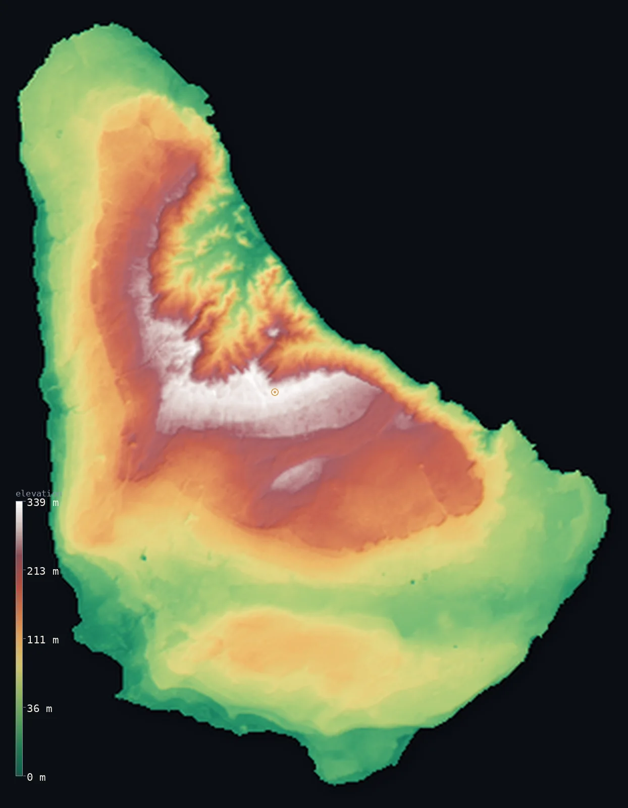
Barbados’s highest point is Mount Hillaby at 1,115 ft (340 m); its lowest is Atlantic Ocean at 0 ft (0 m); the mean elevation is 341 ft (104 m).
- Highest point📚
- 1,115 ft340 m
- Mount Hillaby, the apex of the island's terraced limestone interior.
- Lowest point📚
- 0 ft0 m
- Sea level along Barbados's coral-fringed coast.
- Mean elevation⚙
- 341 ft104 m
- Computed from the GLO-30 surface model across the island.
- Median elevation⚙
- 262 ft80 m
- Half of Barbados lies below this height.
- Elevation range📚
- 1,115 ft340 m
- From sea level to Mount Hillaby's ~340 m summit.
- Official area📚
- 166 mi²430 km²
- A small, low coral-limestone island — the easternmost of the Lesser Antilles.
- Forest cover📚
- 14.7%
- About 15% of the island is wooded; sugarcane historically covered most of the limestone surface.
Highest and lowest points
The highest point of Barbados, in the parish of Saint Andrew, overlooking the eroded Scotland District. Sources give 336–343 m (Britannica 336 m, Wikipedia 340 m); we use 340 m. Unlike most of the island's coral limestone, its summit is built of older sedimentary rock exposed by uplift.
source ↗Barbados at a glance
Barbados is one of the few coral-capped limestone islands in the eastern Caribbean — about 85% of its surface is coral limestone, not the volcanic rock of its neighbours.
source ↗The island's highest point, Mount Hillaby, is built of older sedimentary rock — and its Scotland District is the only place in the Caribbean where this submerged mountain range, an accretionary prism, rises above the sea.
source ↗Barbados has almost no surface rivers: rainwater sinks through the porous limestone into underground channels and caves, which also naturally filter the island's famously clean groundwater.
source ↗Barbados is the easternmost island of the Lesser Antilles, sitting about 160 km out into the Atlantic, off the main arc of the Caribbean islands.
source ↗The coral limestone cap has been arched into two broad anticlines and lifted over the past 600,000 years, giving the island its distinctive terraced, stepped profile.
source ↗Barbados's maritime zone is vast for its size — an exclusive economic zone of nearly 187,000 km², hundreds of times its land area, part of it set aside for offshore oil exploration.
source ↗The Atlantic east coast, around Bathsheba, is so rough with surf and currents that it contrasts sharply with the calm Caribbean beaches of the west — two very different coasts on one small island.
source ↗
Elevation profile of Barbados
The largest share of land, 20%, falls in the 25–50 m band, and 100% of the territory lies below 500 m (1,640 ft).
- below 500 m (1,640 ft)100%
Highest peaks of Barbados
| Peak | Elevation | Range | Note |
|---|---|---|---|
| Mount Hillaby↗ | 1,115 ft340 m | central limestone uplands | Highest point of Barbados, in Saint Andrew, overlooking the Scotland District; built of older sedimentary rock. |
| Chalky Mount↗ | 886 ft270 m | Scotland District | A prominent eroded hill in the Scotland District, known for its clay deposits and pottery; among the higher points of the rugged northeast. |
| Christ Church Ridge (high point)↗ | 295 ft90 m | Christ Church Ridge | A low limestone ridge across the south of the island, reaching about 60–90 m. |
Terrain regions of Barbados
Barbados is one of the few coral-capped limestone islands in the eastern Caribbean — about 85% of its surface is coral limestone, not the volcanic rock of its neighbours. ↗
Limestone uplands and terraces
↗About 85% of the island — a coral-limestone cap 24–30 m thick, arched into broad anticlines and falling to the sea in a series of terraces, with Mount Hillaby as its apex.
Scotland District
↗The rugged northeast, where erosion has stripped the limestone cap to expose older sandstone, shale and chalk — hilly, gullied and prone to landslides, holding most of the island's few surface streams.
Coastal plains and reefs
↗Low coastal lowlands ringed by coral reefs and white-sand beaches — calm and sheltered on the Caribbean west and south, wild and surf-battered on the Atlantic north and east.
Terraced limestone interior
~85%Most of Barbados is a coral-limestone platform 24–30 m thick, uplifted into broad arches and rising inland in a series of gently sloping terraces to its apex at Mount Hillaby (340 m). Rainwater sinks through the porous limestone into underground channels and caves (like Coles Cave) rather than running off in surface rivers.
Scotland District (the eroded northeast)
northeastIn the northeast the limestone cap has eroded away to expose much older oceanic sediments — sandstone, shale and chalk laid down on the sea floor over 60 million years ago. The result is rugged, gullied hill country with jutting ridges, active erosion and the island's only real streams.
Christ Church Ridge and southern lowlands
southA lower limestone anticline (about 60–90 m) crosses the south of the island, with gentle lowlands and the sheltered southwest coast around Bridgetown.
Coasts and coral reefs
coastThe island is ringed by coral reefs that build its white-sand beaches. The Caribbean west and south coasts are calm; the Atlantic north and east coasts are rough, with high surf and strong currents, plus the surviving wetlands of Graeme Hall and Chancery Lane swamps.
City elevations in Barbados
| City | Population | Elevation |
|---|---|---|
| BridgetowncapitalBridgetown, the capital, sits on the sheltered southwest coast at sea level, where the island's terraced limestone slopes down to Carlisle Bay on the Caribbean side. ↗ | 98,511 | 23 ft7 m |
| Speightstown | 3,634 | 13 ft4 m |
| Six Cross Roads | 1,005 | 112 ft34 m |
Elevation sampled at each city centre from the Copernicus GLO-30 model. Cities and population from GeoNames (CC-BY 4.0).
Barbados in comparison
Barbados's terrain rises 1,115 ft (340 m) from sea level to Mount Hillaby — about 4% of the height of Mount Everest, the world's highest point at 29,032 ft (8,849 m).
- Antigua and Barbuda's mean elevation is 91 ft — 250 ft lower; its high point, Boggy Peak (Mount Obama), reaches 1,319 ft (402 m), 203 ft above. Antigua and Barbuda elevation map →
- The Bahamas's mean elevation is 8 ft — 334 ft lower; its high point, Mount Alvernia (Como Hill), reaches 207 ft (63 m), 909 ft below. The Bahamas elevation map →
- Trinidad and Tobago's mean elevation is 273 ft — 68 ft lower; its high point, El Cerro del Aripo, reaches 3,084 ft (940 m), 1,969 ft above. Trinidad and Tobago elevation map →
Frequently asked questions
What is the highest point in Barbados?
- Mount Hillaby, 1,115 ft (340 m), in the parish of Saint Andrew — the apex of the island's terraced limestone interior, overlooking the eroded Scotland District. (Sources cite 336–343 m; we use 340 m.)
What is the average elevation of Barbados?
- Computed from the Copernicus GLO-30 model, the area-weighted mean is 341 ft (104 m). Barbados is a low, terraced coral-limestone island rising gently to about 340 m at Mount Hillaby.
Is Barbados mountainous?
- No — it is a low, gently terraced coral-limestone island. Its highest point, Mount Hillaby, is only about 340 m, and there are no true mountains.
Why is Barbados different from other Caribbean islands?
- Most of its neighbours are volcanic, but Barbados is a coral-capped limestone island formed on an uplifted accretionary prism — its Scotland District is the only place in the Caribbean where that submerged mountain range surfaces.
Does Barbados have rivers?
- Very few — the porous limestone lets rainwater sink underground into channels and caves rather than forming surface rivers, so most of the island's small streams are confined to the Scotland District.
What is the Scotland District?
- The rugged northeast of Barbados, where erosion has stripped away the limestone cap to expose older sandstone, shale and chalk — hilly, gullied, erosion-prone country holding most of the island's streams.
Where is Barbados located?
- It is the easternmost island of the Lesser Antilles, in the Atlantic about 160 km east of the main Windward Islands chain, well out beyond the arc of the Caribbean Sea.
Is this a topographic, relief, contour, or elevation map of Barbados?
- They describe the same thing — terrain height. This page renders Barbados's actual elevation surface in interactive 3D (a relief or topographic view) and reports the elevation statistics computed from it; a contour map shows the same data as lines of equal height.
About this map
The terrain is rendered from the Copernicus GLO-30 digital elevation model (ESA), masked to the BRB-ADM0 boundary from geoBoundaries (gbOpen). Elevation statistics are computed directly from the model; peak names and researched facts are sourced and cited. See the methodology for the full pipeline.
Our area-weighted mean, computed from the Copernicus GLO-30 model, is 341 ft (104 m); the figure commonly cited elsewhere is 689 ft (210 m) (Wikipedia / Geography of Barbados (interior elevation band)). No single authoritative mean is published for Barbados; this corroborating figure is the midpoint of the cited interior elevation band of 180-240 m. Most of the island is lower terraced limestone near the coast, so the whole-island mean is lower. The page shows the area-weighted mean computed from the Copernicus GLO-30 model.
Surveyed national figures: official area · forest cover · high point.
Rendered from Copernicus GLO-30 (ESA, 2021 release), boundaries from geoBoundaries. Generated 2026-07-09.