Canada Elevation Map — Topographic & 3D Terrain
Explore the terrain of Canada in interactive 3D, built from Copernicus GLO-30 satellite elevation data — the mountainous west, the vast interior shield, and the frozen Arctic. Drag to rotate, scroll to zoom, and tap any point to read its elevation.
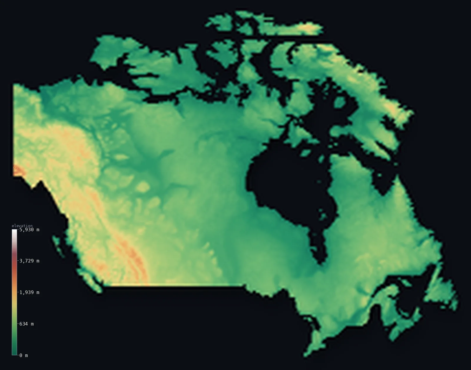
Canada’s highest point is Mount Logan at 19,551 ft (5,959 m); its lowest is Atlantic/Pacific/Arctic Ocean at 0 ft (0 m); the mean elevation is 1,529 ft (466 m).
Canada is really three countries by terrain. In the west rise the Rocky Mountains and the higher Coast ranges, climbing to Mount Logan at 19,551 ft (5,959 m), the highest peak in Canada and the second-highest in North America. Across the centre spreads the ancient, low Canadian Shield and the interior plains. And in the north lies the Arctic Archipelago, a scatter of frozen islands reaching toward the Pole. Most of the country is low — about 69% lies below 500 m (1,640 ft).
- Highest point📚
- 19,551 ft5,959 m
- Canada's highest point is Mount Logan at 19,551 ft (5,959 m), in the remote Saint Elias Mountains of the Yukon — the highest peak in Canada and the second-highest in North America after Denali, with one of the largest base areas of any mountain on Earth.
- Lowest point📚
- 0 ft0 m
- Canada's lowest point is simply its coastline at sea level — a shoreline longer than any other country's on Earth, wrapping three oceans, the Atlantic, the Pacific, and the Arctic.
- Mean elevation⚙
- 1,529 ft466 m
- Canada's mean elevation computed from the GLO-30 model is 1,529 ft (466 m) — moderate for so vast a country, balancing the high western mountains against the low Shield, the interior plains, and the flat Arctic islands that make up most of the land.
- Median elevation⚙
- 1,155 ft352 m
- Half of Canada lies below 1,155 ft (352 m), below the mean — because the great western mountains, though high, are a narrow band, while the low Shield and the northern islands stretch across most of the country.
- Elevation range📚
- 19,551 ft5,959 m
- From sea level to the summit of Mount Logan, Canada spans nearly 19,600 ft of vertical relief — the full range from three-ocean coastline to the second-highest mountain in North America, though the high ground is confined almost entirely to the western cordillera.
- Above 1,000 m (3,281 ft)⚙
- 11%
- About 11% of Canada rises above 1,000 m (3,281 ft) — almost all of it in the western Cordillera, the belt of Rockies, Coast Mountains, and Saint Elias ranges along the Pacific side, with the rest of the vast country lying lower.
- Official area📚
- 3,855,101 mi²9,984,670 km²
- Canada covers about 3.85 million sq mi (9.98 million sq km), the second-largest country on Earth — a span so great it takes in Pacific rainforest, prairie, the rock of the Shield, and a High Arctic of frozen islands reaching within about 800 km of the North Pole.
- Forest cover📚
- 38.2%
- About 38% of Canada is forested — the great boreal forest that belts the country from coast to coast across the Shield and the northern plains, one of the largest intact forest regions left on Earth.
Highest and lowest points
Canada's highest point is Mount Logan, 19,551 ft (5,959 m), in the Saint Elias Mountains of the southwest Yukon near the Alaska border — the highest peak in Canada and the second-highest in North America after Denali. Remote and heavily glaciated, it has one of the largest base circumferences of any mountain on Earth. Nearby Mount Saint Elias, at 18,009 ft (5,489 m), stands directly on the Canada–United States border.
source ↗Canada's lowest point is its coastline at sea level — but that coastline is extraordinary: at over 200,000 km, it is the longest of any country in the world, fronting the Atlantic, Pacific, and Arctic oceans and threading among the thousands of islands of the Arctic Archipelago. The country simply has no inland basin below sea level; its low point is where the immense land finally meets the sea.
source ↗Canada at a glance
Canada's highest point, Mount Logan (5,959 m) in the Yukon, is the second-highest peak in North America after Denali and has one of the largest base areas of any mountain on Earth.
source ↗Canada is three landscapes - the mountainous western Cordillera, the vast low Canadian Shield and interior plains, and the frozen Arctic Archipelago in the north.
source ↗Canada has the longest coastline of any country on Earth, more than 200,000 km, fronting the Atlantic, Pacific, and Arctic oceans.
source ↗The Canadian Shield, an ancient core of Precambrian rock, covers much of the country - low, rocky, and lake-strewn, some of the oldest exposed crust on the planet.
source ↗Canada's Arctic Archipelago is a scatter of large islands reaching to within about 800 km of the North Pole - Baffin Island alone is larger than most countries.
source ↗The great boreal forest belts Canada from the Atlantic to the Pacific across the Shield and northern plains, one of the largest intact forests left on Earth.
source ↗
Elevation profile of Canada
The largest share of land, 69%, falls in the 0–500 m band, and 69% of the territory lies below 500 m (1,640 ft).
- below 500 m (1,640 ft)69%
- 500–1,000 m20%
- 1,000–2,000 m10%
- above 2,000 m (6,562 ft)1%
Highest peaks of Canada
| Peak | Elevation | Range | Note |
|---|---|---|---|
| Mount Logan↗ | 19,551 ft5,959 m | Saint Elias Mountains (Yukon) | Highest point of Canada and second-highest in North America, in the Yukon. |
| Mount Saint Elias↗ | 18,009 ft5,489 m | Saint Elias Mountains | The second-highest peak in Canada, on the Yukon-Alaska border. |
| Mount Lucania↗ | 17,192 ft5,240 m | Saint Elias Mountains (Yukon) | The third-highest peak in Canada, deep in the Yukon icefields. |
| Mount Robson↗ | 12,972 ft3,954 m | Canadian Rockies (British Columbia) | The highest peak of the Canadian Rockies, far to the southeast of the Saint Elias giants. |
| Barbeau Peak↗ | 8,583 ft2,616 m | British Empire Range (Ellesmere Island) | The highest point of the Canadian Arctic Archipelago, on Ellesmere Island in the far north. |
The three Canadas
The Western Cordillera
Along the Pacific side rises the Western Cordillera — the Rocky Mountains, the Coast Mountains, and the Saint Elias range that holds Mount Logan, Canada's highest peak. This belt of high, glaciated mountains carries almost all the country's high ground.
The Shield and interior plains
Across the centre of the country spread the interior plains — the prairies — and the vast Canadian Shield, an ancient low expanse of Precambrian rock and countless lakes. Rocky, worn, and lake-strewn, the Shield is the geological heart of Canada, some of the oldest crust on Earth.
The Arctic Archipelago
In the far north lies the Arctic Archipelago — a scatter of large frozen islands, including Baffin and Ellesmere, reaching toward the North Pole. Ice-capped and nearly uninhabited, these islands add enormous area to the country; much of their surface lies beyond what this map renders in full detail, though it is counted in the country's totals.
How to read this map
Color shows elevation; the raised relief shows real terrain. On this map Canada reads as a high white-and-brown wall in the west — the Cordillera — shading to the low green and grey of the Shield and plains across the centre and the flat Arctic islands in the north.
The 3D relief is the actual GLO-30 elevation data, exaggerated vertically so the western mountains and the low interior both show; the ×N relief slider controls how much. Tap anywhere to read that point's exact elevation.
City elevations in Canada
Canadian cities sit mostly low, strung along the southern border - Toronto and Montreal in the lowlands of the east, Vancouver at sea level on the Pacific. Calgary, on the plains approaching the Rockies, is the highest of the major cities.
| City | Population | Elevation |
|---|---|---|
| Torontoon the shore of Lake Ontario in the eastern lowlands, at about 160 m ↗ | 2,794,356 | 535 ft163 m |
| Montréal | 1,762,949 | 722 ft220 m |
| Calgaryon the western plains at the foot of the Rockies, at about 1,045 m - the highest big city ↗ | 1,306,784 | 3,442 ft1,049 m |
| Ottawacapitalthe capital, in the low Ottawa valley of the east, at about 70 m ↗ | 1,017,449 | 240 ft73 m |
| Edmonton | 1,010,899 | 2,031 ft619 m |
| Winnipeg | 749,607 | 771 ft235 m |
| Vancouver | 662,248 | 236 ft72 m |
| Detroit | 645,705 | 604 ft184 m |
| Québec | 531,902 | 187 ft57 m |
| Halifax | 471,559 | 125 ft38 m |
Elevation sampled at each city centre from the Copernicus GLO-30 model. Cities and population from GeoNames (CC-BY 4.0).
Canada in comparison
Canada's terrain rises 19,551 ft (5,959 m) from sea level to Mount Logan — about 67% of the height of Mount Everest, the world's highest point at 29,032 ft (8,849 m).
- United States's mean elevation is 2,569 ft — 1,040 ft higher; its high point, Denali, reaches 20,308 ft (6,190 m), 758 ft above. United States elevation map →
- Russia's mean elevation is 1,148 ft — 381 ft lower; its high point, Mount Elbrus, reaches 18,510 ft (5,642 m), 1,040 ft below. Russia elevation map →
Frequently asked questions
What is the highest point in Canada?
- Mount Logan, 19,551 ft (5,959 m), in the Yukon - the highest peak in Canada and the second-highest in North America after Denali.
What is the lowest point in Canada?
- Sea level - Canada has the longest coastline of any country, on three oceans, and no inland point below the sea.
What are Canada's main regions?
- Three by terrain: the mountainous Western Cordillera, the vast low Canadian Shield and interior plains, and the frozen Arctic Archipelago in the north.
Why is much of Canada so low?
- Most of the country is the ancient, worn Canadian Shield and the flat Arctic islands - only the narrow western Cordillera is truly high, so about 69% of Canada lies below 500 m.
What is the average elevation of Canada?
- Computed from the GLO-30 model, Canada's area-weighted mean is 1,529 ft (466 m) - moderate, balancing the high western mountains against the low Shield, plains, and Arctic islands.
Is this a topographic, relief, contour, or elevation map of Canada?
- They describe the same thing - terrain height. This page renders the country's actual elevation surface in interactive 3D and reports the statistics computed from it.
About this map
The terrain is rendered from the Copernicus GLO-30 digital elevation model (ESA), masked to the CAN-ADM0 boundary from geoBoundaries (gbOpen). Elevation statistics are computed directly from the model; peak names and researched facts are sourced and cited. See the methodology for the full pipeline.
This map renders 9,528,864 km² across 7174 landmasses of Canada. 971 smaller outlying parts — 349,074 km² in total — lie beyond the area shown here. Area statistics above count the full territory.
Because Canada covers 9,528,864 km², its 3D terrain surface is rendered at roughly 6.9 km per pixel rather than the model’s native 30 m — the full-resolution grid exceeds the render budget for an area this large. The high point and every elevation figure on this page are still measured at native 30 m resolution; only the rendered surface detail is coarsened.
Our area-weighted mean, computed from the Copernicus GLO-30 model, is 1,529 ft (466 m); the figure commonly cited elsewhere is 1,598 ft (487 m) (CIA World Factbook). Canada is mostly low - the vast Canadian Shield, the interior plains and the Arctic lowlands - with high mountains confined to the west, giving a low mean; the page reports the area-weighted figure computed from the Copernicus GLO-30 model. The country is shown as a mainland panel plus its largest Arctic islands, each at reduced surface resolution.
Surveyed national figures: official area · forest cover · high point.
Rendered from Copernicus GLO-30 (ESA, 2021 release), boundaries from geoBoundaries. Generated 2026-07-18.
Bordering countries · 1
Canada shares a land border with these countries — open any one to compare its terrain and highest point.