United States Topographic & Elevation Map
Explore the terrain of the United States in interactive 3D, built from Copernicus GLO-30 satellite elevation data. Drag to rotate, scroll to zoom, and tap any point to read its elevation.
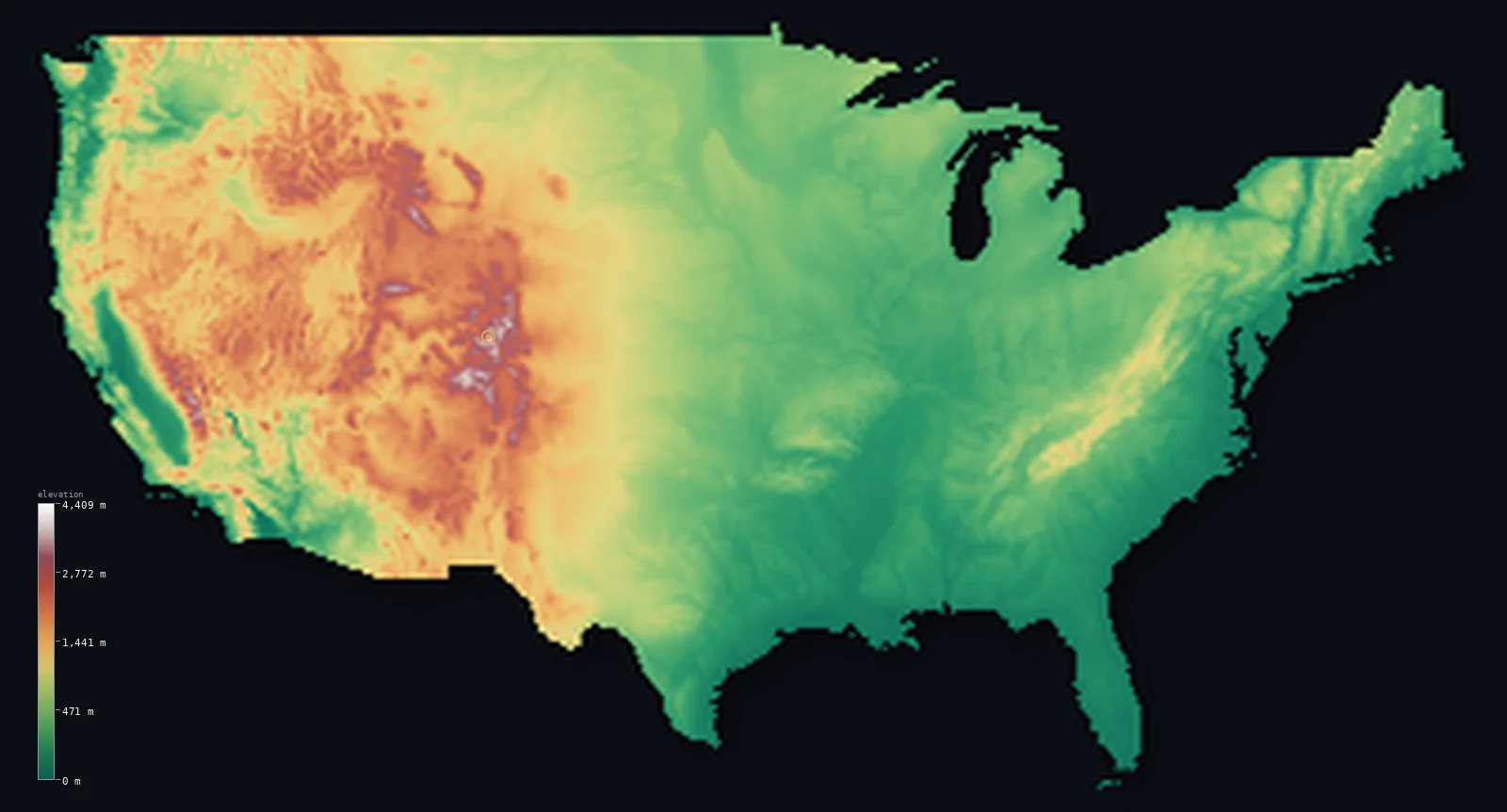
United States’s highest point is Denali at 20,308 ft (6,190 m); its lowest is Badwater Basin, Death Valley at −282 ft (−86 m); the mean elevation is 2,569 ft (783 m).
The contiguous United States has a mean elevation of about 2,569 ft (783 m), though the country spans an enormous range. Its highest point is Denali in Alaska at 20,308 ft (6,190 m) — the highest summit in North America — while its lowest is Badwater Basin in Death Valley, at −282 ft (−86 m) below sea level. Between them lies almost every kind of terrain on Earth.
- Highest point📚
- 20,308 ft6,190 m
- Denali crowns the United States at 20,308 ft (6,190 m), the highest ground in North America — and because it rises from near-sea-level tundra rather than a high plateau, its base-to-summit height is greater than that of Everest, which starts life on a plateau already miles high.
- Lowest point📚
- −282 ft−86 m
- The country's lowest point, Badwater Basin in Death Valley, lies 282 ft (86 m) below sea level — the lowest dry land in North America, and, by recorded air temperature, the hottest place on Earth.
- Mean elevation⚙
- 2,569 ft783 m
- At 2,569 ft (783 m), the average elevation of the United States sits almost exactly mid-range — which is itself the story: the country has no single dominant height but a continent-wide seesaw, the coastal plains and Mississippi lowlands on one side, the mile-high Great Plains and the Rockies on the other.
- Median elevation⚙
- 1,568 ft478 m
- Half of the United States lies below just 1,568 ft (478 m) — more than a thousand feet under the average, and the gap is the point: a small area of very high western mountains drags the mean upward, while the typical American acre is low, flat, and eastern.
- Elevation range📚
- 20,591 ft6,276 m
- From 282 ft below sea level at Badwater Basin to Denali's summit, the United States spans over 20,000 ft of vertical relief — nearly the full range of dry-land elevation found anywhere on Earth outside the Himalaya, all within one country.
- Above 1,000 m (3,281 ft)⚙
- 32%
- Nearly a third of the country — about 32% — lies above 1,000 m (3,281 ft), and almost all of it sits west of a single line: the 100th meridian, beyond which the Great Plains tilt up into the Rockies, the Sierra, and the Cascades.
- Above 2,000 m (6,562 ft)⚙
- 8%
- For all its mountain imagery, only 8% of the United States clears 2,000 m (6,562 ft) — the high terrain is real but concentrated in the Colorado Rockies, the high Sierra, and the Alaska Range, while the other nine-tenths of the country lies lower than a Colorado ski town.
- Official area📚
- 3,796,741 mi²9,833,517 km²
- At about 3,796,741 sq mi (9,833,517 sq km), the United States is a continent in three separate pieces — the contiguous states, Alaska, and Hawaii — spanning so much latitude that a single country reaches from the Arctic Ocean to the tropics.
- Forest cover📚
- 33.9%
- About a third of the United States — 33.9% — is forest, but it hangs unevenly on the map: dense and wet in the Pacific Northwest and the Southeast, nearly absent across the Great Plains — a rough green shadow of where the rain falls.
Highest and lowest points
The highest point of the United States, Denali (federally Mount McKinley), 20,308 ft (6,190 m) - the crowning peak of the Alaska Range in interior Alaska and the highest mountain in North America. Shown in this page's Alaska panel. Measured base to peak on land, it is among the tallest mountains on Earth; the contiguous high point, Mount Whitney, at 14,505 ft (4,421 m), is far lower.
source ↗The lowest point of the United States, Badwater Basin in Death Valley, California, lies 282 ft (86 m) below sea level - also the lowest land in North America. A vast salt flat on the floor of Death Valley, which holds the highest air temperature ever reliably recorded on Earth. It sits only about 135 km from Mount Whitney (14,505 ft), the highest point in the contiguous US - the greatest high-to-low relief over such a short distance in the country.
source ↗Denali, the national high point, lies in a detached part of the country shown in its own panel rather than the main map view. The highest point within the main view is Mount Whitney at 14,505 ft (4,421 m). The headline figure above is the surveyed elevation of the recognised national high point.
United States at a glance
The ten highest major summits in the United States are all in Alaska — the contiguous states' highest peak, California's Mount Whitney, would rank only eleventh nationally.
source ↗The Great Plains tilt so gradually upward from east to west — from about 500 ft near the Mississippi to over 5,000 ft at the foot of the Rockies — that the climb is nearly imperceptible on the ground, yet it lifts the land by a mile across the interior.
source ↗Hawaii's Mauna Kea, measured from its base on the ocean floor, is the tallest mountain on Earth.
source ↗Alaska's Aleutian Islands stretch so far west that they cross the 180th meridian into the Eastern Hemisphere.
source ↗The United States has territory in both the Arctic and the tropics — from Alaska's Arctic coast to Hawaii, only about 1,300 km north of the equator — spanning a wider range of latitude and climate than almost any other country.
source ↗
Elevation profile of United States
The largest share of land, 51%, falls in the 0–500 m band, with the land split almost evenly above and below 500 m (1,640 ft).
- below 500 m (1,640 ft)51%
- 500–1,000 m17%
- 1,000–2,000 m24%
- above 2,000 m (6,562 ft)8%
Highest peaks of United States
| Peak | Elevation | Range | Note |
|---|---|---|---|
| Denali↗ | 20,308 ft6,190 m | Alaska Range | Highest point of the United States and of North America, in interior Alaska. |
| Mount Saint Elias↗ | 18,009 ft5,489 m | Saint Elias Mountains | The second-highest peak in the US, on the Alaska-Yukon border. |
| Mount Whitney↗ | 14,505 ft4,421 m | Sierra Nevada | The highest point of the contiguous United States, in California. |
| Mount Elbert↗ | 14,439 ft4,401 m | Rocky Mountains (Sawatch Range) | The highest peak of the Rocky Mountains, in Colorado. |
| Mauna Kea↗ | 13,802 ft4,207 m | Hawaiian Islands (shield volcano) | The highest point of Hawaii and, measured from its ocean-floor base, the tallest mountain on Earth. |
| Mauna Loa↗ | 13,678 ft4,169 m | Hawaiian Islands (shield volcano) | The most voluminous mountain on Earth, an active shield volcano on Hawaii's Big Island; last erupted in 2022. |
A region-by-region tour of US terrain
The Atlantic Coast & Appalachians (East)
The eastern seaboard begins near sea level along the Atlantic Coastal Plain, then rises gently into the ancient, worn Appalachian Mountains — a chain of rounded ridges and valleys running from the Deep South up into New England. These are old mountains, smoothed by hundreds of millions of years of erosion, rarely breaking 2,000 m. It is the softest, most rolling high country in the United States.
The Interior Plains (Center)
West of the Appalachians the land opens into the vast Great Plains — the flat heartland of the continent. The surface tilts almost imperceptibly upward from east to west, climbing from a few hundred metres near the Mississippi to over 1,500 m where it meets the Rockies. This long, quiet ramp is why the country's median elevation is just 1,568 ft (478 m) — far below the mean, pulled down by all this low, level ground.
The Rocky Mountains (West)
The Rockies are the great spine of the American West, a broad belt of high ranges where the terrain suddenly stands up. This is where the country's interior reaches its greatest heights — Colorado's Mount Elbert tops out at 14,439 ft (4,401 m), one of dozens of Rocky Mountain peaks above 4,000 m. The abruptness of the rise, plains to summits, is one of the most dramatic transitions on the map.
The Basin & Range and the Southwest
Between the Rockies and the Sierra lies a strange, stretched landscape of parallel fault-block ranges and deep sunken basins. It holds both extremes of the contiguous country: Badwater Basin in Death Valley at −282 ft (−86 m), the lowest land in North America, sits only about 135 km from Mount Whitney at 14,505 ft (4,421 m) — the highest point in the Lower 48. Nowhere else in the US do the highest and lowest points stand so close together.
The Pacific Ranges (Far West)
Along the western edge, the Sierra Nevada and the volcanic Cascades rise steeply before the land drops to the Pacific. Mount Whitney crowns the Sierra; the Cascades add a line of snow-capped volcanoes. This is young, sharp, still-rising terrain — the opposite of the worn Appalachians on the far side of the continent.
Alaska & Hawaii
The two non-contiguous states hold the country's true extremes. Denali, in Alaska's Alaska Range, is the highest peak in North America, and nearby Mount Saint Elias stands at 18,009 ft (5,489 m). In the Pacific, Hawaii's Mauna Kea (13,802 ft / 4,207 m) and Mauna Loa (13,678 ft / 4,169 m) are shield volcanoes that rise straight off the deep seafloor.
How to read this map
Color shows elevation; the raised relief shows real terrain. The color bands run from green at sea level up through browns and whites at the highest peaks — the same idea as the contour lines on a classic topographic map, but shown as a continuous surface.
The 3D relief is the actual GLO-30 elevation data, exaggerated vertically so subtle terrain stays visible; the ×N relief slider controls how much. Tap anywhere on the map to read that point's exact elevation.
Explore any US state in 3D
Every US state has its own interactive elevation map — from the flat expanse of Florida (high point just 105 m) to the alpine spine of Colorado (over 50 peaks above 4,000 m). Tap a state to explore its terrain in 3D.
- Alabama735 m
- Alaska6,190 m
- Arizona3,852 m
- Arkansas839 m
- California4,421 m
- Colorado4,401 m
- Connecticut725 m
- Delaware137 m
- Florida105 m
- Georgia1,458 m
- Hawaii4,205 m
- Idaho3,859 m
- Illinois376 m
- Indiana383 m
- Iowa509 m
- Kansas1,232 m
- Kentucky1,263 m
- Louisiana163 m
- Maine1,606 m
- Maryland1,024 m
- Massachusetts1,063 m
- Michigan603 m
- Minnesota701 m
- Mississippi246 m
- Missouri540 m
- Montana3,904 m
- Nebraska1,653 m
- Nevada4,005 m
- New Hampshire1,917 m
- New Jersey550 m
- New Mexico4,013 m
- New York1,629 m
- North Carolina2,037 m
- North Dakota1,069 m
- Ohio472 m
- Oklahoma1,516 m
- Oregon3,429 m
- Pennsylvania979 m
- Rhode Island247 m
- South Carolina1,085 m
- South Dakota2,207 m
- Tennessee2,025 m
- Texas2,667 m
- Utah4,120 m
- Vermont1,339 m
- Virginia1,746 m
- Washington4,392 m
- West Virginia1,482 m
- Wisconsin595 m
- Wyoming4,209 m
Or zoom out to North America.
City elevations in United States
America's biggest cities cluster low and coastal — New York at 118 ft (36 m), Houston almost at sea level, Los Angeles and San Diego both under 310 ft — because that's where deep-water ports and flat land met. The outlier is Phoenix, which grew in the high Arizona desert at 1,096 ft (334 m), air-conditioned into a metropolis where geography never invited one.
| City | Population | Elevation |
|---|---|---|
| New York Citythe largest US city, built on the harbor at the mouth of the Hudson ↗ | 8,804,190 | 118 ft36 m |
| Los Angelesspread across a coastal basin between the Pacific and the San Gabriel Mountains ↗ | 3,820,914 | 302 ft92 m |
| Chicagoon the flat lakeplain at the southwest shore of Lake Michigan ↗ | 2,664,452 | 587 ft179 m |
| Houstonon the near-flat Gulf coastal plain, barely above sea level and prone to flooding ↗ | 2,314,157 | 46 ft14 m |
| Phoenixthe high exception - a desert metropolis on the Sonoran plateau of central Arizona ↗ | 1,650,070 | 1,096 ft334 m |
| Philadelphiaon the low fall-line between the coastal plain and the Piedmont ↗ | 1,573,916 | 62 ft19 m |
| San Antonioon the Balcones Escarpment where the coastal plain meets the Texas Hill Country ↗ | 1,526,656 | 663 ft202 m |
| San Diegoon the southern California coast at the Mexican border ↗ | 1,404,452 | 39 ft12 m |
| Dallason the rolling blackland prairie of north-central Texas ↗ | 1,326,087 | 436 ft133 m |
| Washingtoncapitalthe capital, on the tidal Potomac at the fall line, near sea level ↗ | 689,545 | 26 ft8 m |
Elevation sampled at each city centre from the Copernicus GLO-30 model. Cities and population from GeoNames (CC-BY 4.0).
United States in comparison
United States's terrain rises 20,591 ft (6,276 m) from Badwater Basin, Death Valley, 282 ft (86 m) below sea level to Denali — about 71% of the height of Mount Everest, the world's highest point at 29,032 ft (8,849 m).
- Canada's mean elevation is 1,529 ft — 1,040 ft lower; its high point, Mount Logan, reaches 19,551 ft (5,959 m), 758 ft below. Canada elevation map →
- Mexico's mean elevation is 3,415 ft — 846 ft higher; its high point, Pico de Orizaba (Citlaltepetl), reaches 18,491 ft (5,636 m), 1,818 ft below. Mexico elevation map →
- Russia's mean elevation is 1,148 ft — 1,421 ft lower; its high point, Mount Elbrus, reaches 18,510 ft (5,642 m), 1,798 ft below. Russia elevation map →
Frequently asked questions
What is the highest point in the United States?
- Denali, 20,308 ft (6,190 m), in Alaska's Alaska Range - the highest mountain in North America.
What is the highest point in the contiguous United States?
- Mount Whitney, 4,421 m, in California's Sierra Nevada - the high point of the main map view.
What is the average elevation of the United States?
- Computed from the Copernicus GLO-30 model, the area-weighted mean is 2,569 ft (783 m) - moderate, balancing low eastern and interior lands against the high West.
What is the lowest point in the United States?
- Badwater Basin in Death Valley, −282 ft (−86 m) - also the lowest point in North America.
Why is the map shown in three parts?
- US territory falls in three widely separated pieces - the contiguous states, Alaska and Hawaii - so each is rendered as its own panel; area statistics count all of them together.
Is this a topographic, relief, contour, or elevation map of the United States?
- They describe the same thing - terrain height. This page renders the country's actual elevation surface in interactive 3D (a relief or topographic view) and reports the statistics computed from it; a contour map shows the same data as lines of equal height.
About this map
The terrain is rendered from the Copernicus GLO-30 digital elevation model (ESA), masked to the USA-ADM0 boundary from geoBoundaries (gbOpen). Elevation statistics are computed directly from the model; peak names and researched facts are sourced and cited. See the methodology for the full pipeline.
This map renders 7,809,970 km² across 105 landmasses of United States. 185 smaller outlying parts — 1,556,539 km² in total — lie beyond the area shown here, including the landmass that holds the national high point. Area statistics above count the full territory.
Because United States covers 7,809,970 km², its 3D terrain surface is rendered at roughly 4.5 km per pixel rather than the model’s native 30 m — the full-resolution grid exceeds the render budget for an area this large. The high point and every elevation figure on this page are still measured at native 30 m resolution; only the rendered surface detail is coarsened.
Our area-weighted mean, computed from the Copernicus GLO-30 model, is 2,569 ft (783 m); the figure commonly cited elsewhere is 2,493 ft (760 m) (CIA World Factbook). The United States spans low coastal plains, the vast interior lowlands, and high western mountains, giving a moderate mean; the page reports the area-weighted figure computed from the Copernicus GLO-30 model. The country is shown as three panels - the contiguous states, Alaska and Hawaii - each rendered at reduced surface resolution.
Surveyed national figures: official area · forest cover · high point.
Rendered from Copernicus GLO-30 (ESA, 2021 release), boundaries from geoBoundaries. Generated 2026-07-17.
Bordering countries · 2
United States shares a land border with these countries — open any one to compare its terrain and highest point.