Wisconsin Elevation Map
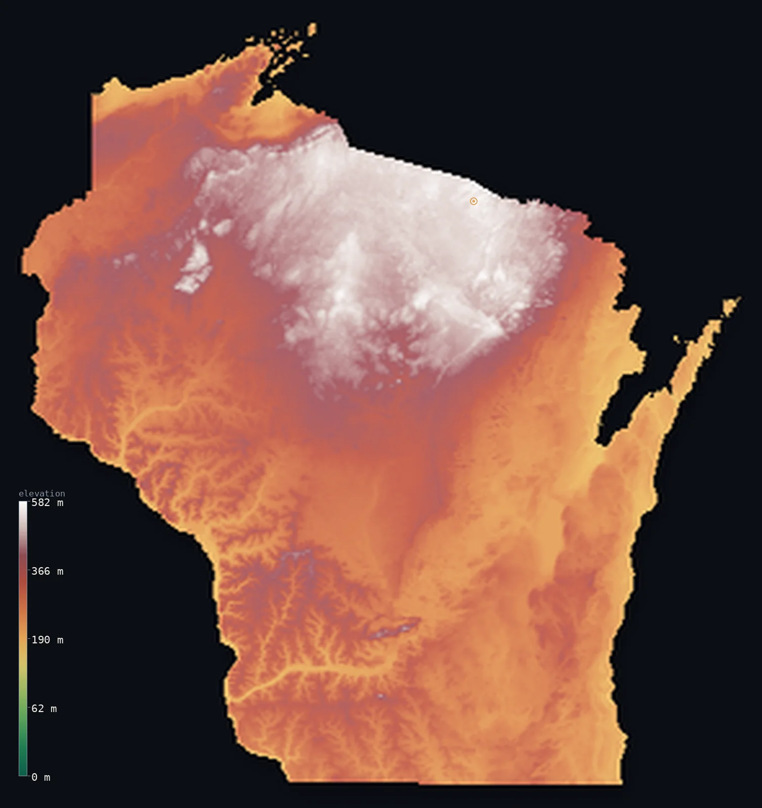
Wisconsin’s highest point is Timms Hill at 1,952 ft (595 m); its lowest is Lake Michigan at 577 ft (176 m); the mean elevation is 1,093 ft (333 m).
- Highest point📚
- 1,952 ft595 m
- Timms Hill.
- Lowest point📚
- 577 ft176 m
- Lake Michigan.
- Mean elevation⚙
- 1,093 ft333 m
- Computed from the GLO-30 surface model.
- Median elevation⚙
- 1,033 ft315 m
- Half of Wisconsin lies below this height.
- Elevation range📚
- 1,375 ft419 m
- From 176 m to Timms Hill's 595 m.
- Official area📚
- 65,496 mi²169,635 km²
- Wisconsin.
Wisconsin at a glance
Southwestern Wisconsin's Driftless Area was never covered by glaciers, leaving unusually rugged valleys.
source ↗Timms Hill, the high point, is a glacial hill barely 400 m above the surrounding country.
source ↗The Niagara Escarpment, the same ridge that makes Niagara Falls, forms Wisconsin's Door Peninsula.
source ↗Nearly all of Wisconsin's surface was shaped by Ice Age glaciers - except the Driftless corner.
source ↗The state's lowest point is the surface of Lake Michigan, not the sea.
source ↗
Elevation profile of Wisconsin
The largest share of land, 26%, falls in the 250–300 m band, and 96% of the territory lies below 500 m (1,640 ft).
- below 500 m (1,640 ft)96%
- 500–1,000 m4%
Highest and lowest points
The highest point of Wisconsin, Timms Hill, 595 m, a low, forested rise in the northern lake country - a glacial hill crowned with a lookout tower, typical of a state shaped almost entirely by ice.
source ↗Highest peaks of Wisconsin
| Peak | Elevation | Range | Note |
|---|---|---|---|
| Timms Hill↗ | 1,952 ft595 m | Northern Highland | Highest point of Wisconsin, a glacial rise. |
| Pearson Hill↗ | 1,942 ft592 m | Northern Highland | Just below Timms Hill, its close neighbour. |
| Sugarbush Hill↗ | 1,919 ft585 m | Northern Highland | A high point of the northern forest. |
| Rib Mountain↗ | 1,903 ft580 m | Marathon County | A prominent quartzite monadnock near Wausau. |
| Blue Mounds↗ | 1,542 ft470 m | Driftless Area | The high point of the unglaciated Driftless southwest. |
Terrain regions of Wisconsin
Southwestern Wisconsin's Driftless Area was never covered by glaciers, leaving unusually rugged valleys. ↗
The Northern Highland
↗Northern Wisconsin is the Northern Highland, an upland of ancient rock, glacial hills, forest and lakes, holding Timms Hill (595 m), the state summit. This is t
The central plain and eastern ridges
↗Central Wisconsin holds a flat, sandy plain, the bed of a vanished glacial lake, while eastern Wisconsin rolls in ridges and drumlins toward Lake Michigan, incl
The Driftless Area
↗Southwestern Wisconsin is the heart of the Driftless Area, a region the glaciers missed entirely. Instead of flattening it, the lack of ice left a rugged landsc
The Northern Highland
the northNorthern Wisconsin is the Northern Highland, an upland of ancient rock, glacial hills, forest and lakes, holding Timms Hill (595 m), the state summit. This is the wild lake-and-woods country, part of the Canadian Shield edge, dotted with thousands of glacial lakes.
The central plain and eastern ridges
the centre and eastCentral Wisconsin holds a flat, sandy plain, the bed of a vanished glacial lake, while eastern Wisconsin rolls in ridges and drumlins toward Lake Michigan, including the long Niagara Escarpment that forms the Door Peninsula reaching into the lake.
The Driftless Area
the southwestSouthwestern Wisconsin is the heart of the Driftless Area, a region the glaciers missed entirely. Instead of flattening it, the lack of ice left a rugged landscape of deep, branching valleys, steep bluffs and rocky ridges along the Mississippi and Wisconsin rivers - unlike anywhere else in the upper Midwest.
City elevations in Wisconsin
| City | Population | Elevation |
|---|---|---|
| Milwaukee | 563,531 | 614 ft187 m |
| Madison | 280,305 | 889 ft271 m |
| Green Bay | 105,207 | 594 ft181 m |
| Kenosha | 99,858 | 610 ft186 m |
| Eau Claire | 67,778 | 797 ft243 m |
| Oshkosh | 66,555 | 774 ft236 m |
| Janesville | 64,123 | 840 ft256 m |
| La Crosse | 52,306 | 676 ft206 m |
| Sheboygan | 48,797 | 630 ft192 m |
| Wausau | 39,094 | 1,214 ft370 m |
Elevation sampled at each city centre from the Copernicus GLO-30 model. Cities and population from GeoNames (CC-BY 4.0).
Wisconsin in comparison
Wisconsin's terrain rises 1,375 ft (419 m) from Lake Michigan (577 ft (176 m)) to Timms Hill — about 5% of the height of Mount Everest, the world's highest point at 29,032 ft (8,849 m).
Frequently asked questions
What is the highest point in Wisconsin?
- Timms Hill, 1,952 ft (595 m).
What is the average elevation of Wisconsin?
- About 320 m according to the USGS; this page also reports the area-weighted mean computed from the Copernicus GLO-30 model, 1,093 ft (333 m).
What is the lowest point in Wisconsin?
- Lake Michigan, 577 ft (176 m).
Southwestern Wisconsin's Driftless Area was never covered by glaciers?
- Southwestern Wisconsin's Driftless Area was never covered by glaciers, leaving unusually rugged valleys.
Where is the highest ground in Wisconsin?
- Northern Wisconsin is the Northern Highland, an upland of ancient rock, glacial hills, forest and lakes, holding Timms Hill (595 m), the state summit. This is the wild lake-and-woods country, part of
Is this a topographic, relief, contour, or elevation map of Wisconsin?
- They describe the same thing - terrain height. This page renders Wisconsin's actual elevation surface in interactive 3D (a relief or topographic view) and reports the statistics computed from it; a contour map shows the same data as lines of equal height.
About this map
The terrain is rendered from the Copernicus GLO-30 digital elevation model (ESA), masked to the US-WI boundary from geoBoundaries (gbOpen). Elevation statistics are computed directly from the model; peak names and researched facts are sourced and cited. See the methodology for the full pipeline.
Our area-weighted mean, computed from the Copernicus GLO-30 model, is 1,093 ft (333 m); the figure commonly cited elsewhere is 1,050 ft (320 m) (U.S. Geological Survey). Wisconsin's mean elevation is about 320 m; the page reports the area-weighted figure computed from the Copernicus GLO-30 model.
Surveyed national figures: official area · high point.
Rendered from Copernicus GLO-30 (ESA, 2021 release), boundaries from geoBoundaries. Generated 2026-07-14.