Michigan Elevation Map
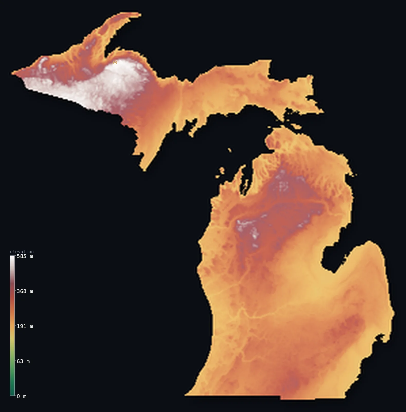
Michigan’s highest point is Mount Arvon at 1,978 ft (603 m); its lowest is Lake Erie at 571 ft (174 m); the mean elevation is 912 ft (278 m).
- Highest point📚
- 1,978 ft603 m
- Mount Arvon.
- Lowest point📚
- 571 ft174 m
- Lake Erie.
- Mean elevation⚙
- 912 ft278 m
- Computed from the GLO-30 surface model.
- Median elevation⚙
- 850 ft259 m
- Half of Michigan lies below this height.
- Elevation range📚
- 1,407 ft429 m
- From 174 m to Mount Arvon's 603 m.
- Official area📚
- 96,714 mi²250,487 km²
- Michigan.
Michigan at a glance
Michigan's high point, Mount Arvon, is only 1 m higher than nearby Mount Curwood - long mistaken for the summit.
source ↗No point in Michigan is more than about 10 km from a Great Lake or inland lake.
source ↗The Upper Peninsula holds some of the oldest exposed rock in North America.
source ↗Michigan has the longest freshwater coastline of any US state, wrapped by four Great Lakes.
source ↗The state's lowest point is a lake surface, not sea level - Michigan touches no ocean.
source ↗
Elevation profile of Michigan
The largest share of land, 33%, falls in the 200–250 m band, and 98% of the territory lies below 500 m (1,640 ft).
- below 500 m (1,640 ft)98%
- 500–1,000 m2%
Highest and lowest points
The highest point of Michigan, Mount Arvon, 603 m, a low, forested rise in the wild Huron Mountains of the Upper Peninsula - so gentle that its status as the state high point was only settled by survey in 1982.
source ↗Highest peaks of Michigan
| Peak | Elevation | Range | Note |
|---|---|---|---|
| Mount Arvon↗ | 1,978 ft603 m | Huron Mountains (Upper Peninsula) | Highest point of Michigan, a forested rise. |
| Mount Curwood↗ | 1,975 ft602 m | Huron Mountains | Just 1 m lower than Arvon - long thought the highest. |
| Government Peak↗ | 1,955 ft596 m | Porcupine Mountains | A high point of the Porcupine Mountains. |
| Summit Peak↗ | 1,949 ft594 m | Porcupine Mountains | A named high point of the western Upper Peninsula. |
| Brockway Mountain↗ | 719 ft219 m | Keweenaw Peninsula | A scenic high ridge above Lake Superior on the Keweenaw. |
Terrain regions of Michigan
Michigan's high point, Mount Arvon, is only 1 m higher than nearby Mount Curwood - long mistaken for the summit. ↗
The Upper Peninsula highlands
↗Michigan's highest, wildest ground is the western Upper Peninsula - the ancient rock of the Huron and Porcupine Mountains, worn hills of some of the oldest rock
The Great Lakes lowlands
↗Most of Michigan is low, glacier-shaped lowland - the two great peninsulas wrapped by four of the five Great Lakes. Rolling moraines, flat lake plains, dunes an
The southern plains and coasts
↗Southern Lower Michigan flattens into gently rolling farmland and the state's populous corridor, sloping to the shores of Lakes Michigan, Huron and Erie. The lo
The Upper Peninsula highlands
the far northwestMichigan's highest, wildest ground is the western Upper Peninsula - the ancient rock of the Huron and Porcupine Mountains, worn hills of some of the oldest rock in North America, holding Mount Arvon (603 m). This is rugged, forested, snow-heavy country along the shore of Lake Superior.
The Great Lakes lowlands
most of the stateMost of Michigan is low, glacier-shaped lowland - the two great peninsulas wrapped by four of the five Great Lakes. Rolling moraines, flat lake plains, dunes and thousands of inland lakes cover the land, all left by the Ice Age glaciers that carved the basins around them.
The southern plains and coasts
the southSouthern Lower Michigan flattens into gently rolling farmland and the state's populous corridor, sloping to the shores of Lakes Michigan, Huron and Erie. The lowest point is on Lake Erie at 174 m - though that is a lake surface, not the sea, since Michigan touches no ocean.
City elevations in Michigan
| City | Population | Elevation |
|---|---|---|
| Detroit | 645,705 | 604 ft184 m |
| Grand Rapids | 195,097 | 650 ft198 m |
| Ann Arbor | 117,070 | 889 ft271 m |
| Lansing | 112,644 | 860 ft262 m |
| Flint | 98,310 | 758 ft231 m |
| Kalamazoo | 76,041 | 794 ft242 m |
| Sarnia | 72,125 | 604 ft184 m |
| Sault Ste. Marie | 72,051 | 623 ft190 m |
| Midland | 42,200 | 636 ft194 m |
| Granger | 30,465 | 804 ft245 m |
Elevation sampled at each city centre from the Copernicus GLO-30 model. Cities and population from GeoNames (CC-BY 4.0).
Michigan in comparison
Michigan's terrain rises 1,407 ft (429 m) from Lake Erie (571 ft (174 m)) to Mount Arvon — about 5% of the height of Mount Everest, the world's highest point at 29,032 ft (8,849 m).
Frequently asked questions
What is the highest point in Michigan?
- Mount Arvon, 1,978 ft (603 m).
What is the average elevation of Michigan?
- About 270 m according to the USGS; this page also reports the area-weighted mean computed from the Copernicus GLO-30 model, 912 ft (278 m).
What is the lowest point in Michigan?
- Lake Erie, 571 ft (174 m).
Michigan's high point?
- Michigan's high point, Mount Arvon, is only 1 m higher than nearby Mount Curwood - long mistaken for the summit.
Where is the highest ground in Michigan?
- Michigan's highest, wildest ground is the western Upper Peninsula - the ancient rock of the Huron and Porcupine Mountains, worn hills of some of the oldest rock in North America, holding Mount Arvon (
Is this a topographic, relief, contour, or elevation map of Michigan?
- They describe the same thing - terrain height. This page renders Michigan's actual elevation surface in interactive 3D (a relief or topographic view) and reports the statistics computed from it; a contour map shows the same data as lines of equal height.
About this map
The terrain is rendered from the Copernicus GLO-30 digital elevation model (ESA), masked to the US-MI boundary from geoBoundaries (gbOpen). Elevation statistics are computed directly from the model; peak names and researched facts are sourced and cited. See the methodology for the full pipeline.
This map renders 149,757 km² across 33 landmasses of Michigan. 78 smaller outlying parts — 1,285 km² in total — lie beyond the area shown here. Area statistics above count the full territory.
Our area-weighted mean, computed from the Copernicus GLO-30 model, is 912 ft (278 m); the figure commonly cited elsewhere is 886 ft (270 m) (U.S. Geological Survey). Michigan's mean elevation is about 270 m; the page reports the area-weighted figure computed from the Copernicus GLO-30 model.
Surveyed national figures: official area · high point.
Rendered from Copernicus GLO-30 (ESA, 2021 release), boundaries from geoBoundaries. Generated 2026-07-14.