Indiana Elevation Map
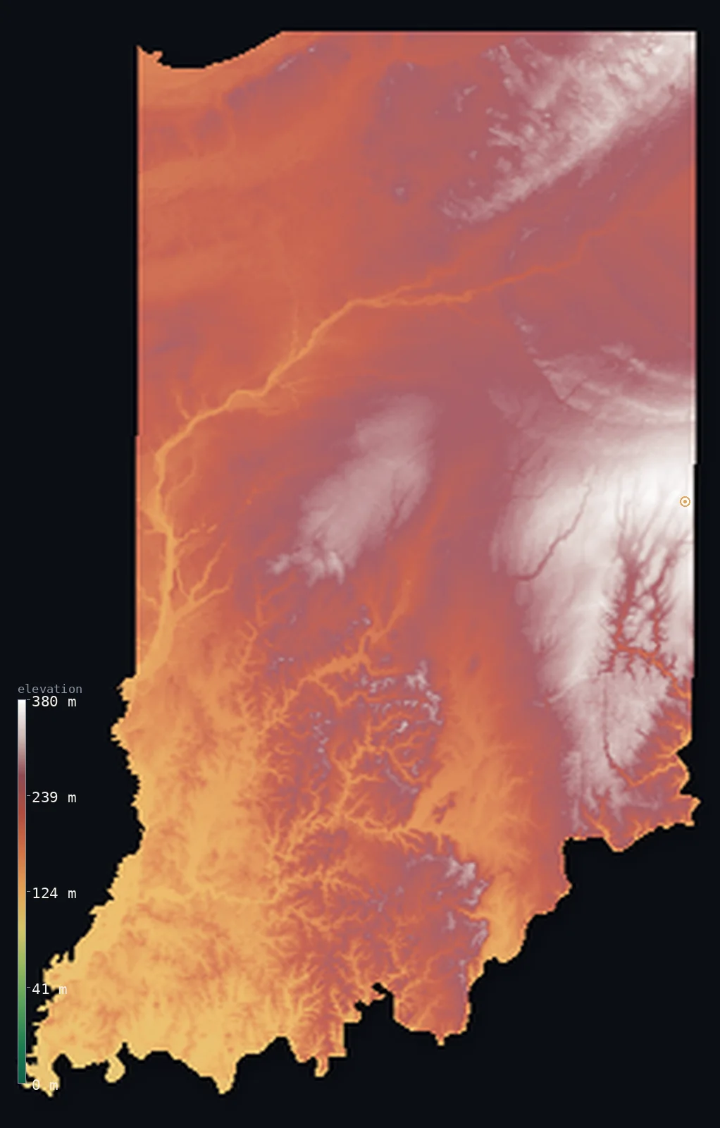
Indiana’s highest point is Hoosier Hill at 1,257 ft (383 m); its lowest is Ohio River at 322 ft (98 m); the mean elevation is 751 ft (229 m).
- Highest point📚
- 1,257 ft383 m
- Hoosier Hill.
- Lowest point📚
- 322 ft98 m
- Ohio River.
- Mean elevation⚙
- 751 ft229 m
- Computed from the GLO-30 surface model.
- Median elevation⚙
- 768 ft234 m
- Half of Indiana lies below this height.
- Elevation range📚
- 935 ft285 m
- From 98 m to Hoosier Hill's 383 m.
- Official area📚
- 36,419 mi²94,326 km²
- Indiana.
Indiana at a glance
Hoosier Hill, the high point, is a low rise in a farm field reached through a small clearing in the woods.
source ↗Southern Indiana escaped the glaciers, leaving hills, caves and karst the flat north lacks.
source ↗The Indiana Dunes along Lake Michigan rise up to 60 m of shifting sand.
source ↗Indiana's whole relief spans under 300 m, among the gentlest of any state.
source ↗Central Indiana's glacier-flattened plains are some of the flattest farmland in the country.
source ↗
Elevation profile of Indiana
The largest share of land, 18%, falls in the 240–260 m band, and 100% of the territory lies below 500 m (1,640 ft).
- below 500 m (1,640 ft)100%
Highest and lowest points
The highest point of Indiana, Hoosier Hill, 383 m, a low rise in a farm field near the Ohio border - marked by a small clearing in the trees, one of the gentlest state high points in the country.
source ↗Highest peaks of Indiana
| Peak | Elevation | Range | Note |
|---|---|---|---|
| Hoosier Hill↗ | 1,257 ft383 m | Eastern Till Plains | Highest point of Indiana, a farm-field rise. |
| Randolph County high ground↗ | 1,247 ft380 m | Eastern Till Plains | High till plain around Hoosier Hill. |
| Weed Patch Hill↗ | 1,247 ft380 m | Brown County Hills | A high knob in the scenic Brown County hills. |
| Southern Hills highpoint↗ | 1,050 ft320 m | Norman Upland | High ground of the unglaciated south. |
| Pennyroyal Plateau edge↗ | 984 ft300 m | Southern Indiana | High points of the karst south. |
Terrain regions of Indiana
Hoosier Hill, the high point, is a low rise in a farm field reached through a small clearing in the woods. ↗
The northern lakes and moraines
↗Northern Indiana is glacier-shaped country - flat lake plains near Lake Michigan, including the Indiana Dunes, and a belt of rolling moraines and hundreds of sm
The central till plains
↗Central Indiana is flat to gently rolling till plain, deep-soiled Corn Belt farmland flattened by the glaciers. It holds Hoosier Hill (383 m), the state's high
The southern hills
↗Southern Indiana, below the glacial limit, is the state's rugged corner - the forested knobs and hollows of the Norman Upland and Brown County hills, and the ka
The northern lakes and moraines
the northNorthern Indiana is glacier-shaped country - flat lake plains near Lake Michigan, including the Indiana Dunes, and a belt of rolling moraines and hundreds of small lakes left by the Ice Age across the north of the state.
The central till plains
the centreCentral Indiana is flat to gently rolling till plain, deep-soiled Corn Belt farmland flattened by the glaciers. It holds Hoosier Hill (383 m), the state's high point, a barely perceptible rise near the Ohio line - most of central Indiana is close to dead level.
The southern hills
the southSouthern Indiana, below the glacial limit, is the state's rugged corner - the forested knobs and hollows of the Norman Upland and Brown County hills, and the karst country of caves, sinkholes and springs along the Ohio River, which forms the low southern border down to 98 m.
City elevations in Indiana
| City | Population | Elevation |
|---|---|---|
| Indianapolis | 887,642 | 715 ft218 m |
| Fort Wayne | 260,326 | 814 ft248 m |
| Evansville | 119,943 | 384 ft117 m |
| South Bend | 101,516 | 699 ft213 m |
| Bloomington | 84,067 | 797 ft243 m |
| Hammond | 77,614 | 607 ft185 m |
| Lafayette | 71,111 | 702 ft214 m |
| Muncie | 70,087 | 951 ft290 m |
| Terre Haute | 60,825 | 502 ft153 m |
| Owensboro | 59,042 | 397 ft121 m |
Elevation sampled at each city centre from the Copernicus GLO-30 model. Cities and population from GeoNames (CC-BY 4.0).
Indiana in comparison
Indiana's terrain rises 935 ft (285 m) from Ohio River (322 ft (98 m)) to Hoosier Hill — about 3% of the height of Mount Everest, the world's highest point at 29,032 ft (8,849 m).
Frequently asked questions
What is the highest point in Indiana?
- Hoosier Hill, 1,257 ft (383 m).
What is the average elevation of Indiana?
- About 210 m according to the USGS; this page also reports the area-weighted mean computed from the Copernicus GLO-30 model, 751 ft (229 m).
What is the lowest point in Indiana?
- Ohio River, 322 ft (98 m).
Hoosier Hill?
- Hoosier Hill, the high point, is a low rise in a farm field reached through a small clearing in the woods.
Where is the highest ground in Indiana?
- Northern Indiana is glacier-shaped country - flat lake plains near Lake Michigan, including the Indiana Dunes, and a belt of rolling moraines and hundreds of small lakes left by the Ice Age across the
Is this a topographic, relief, contour, or elevation map of Indiana?
- They describe the same thing - terrain height. This page renders Indiana's actual elevation surface in interactive 3D (a relief or topographic view) and reports the statistics computed from it; a contour map shows the same data as lines of equal height.
About this map
The terrain is rendered from the Copernicus GLO-30 digital elevation model (ESA), masked to the US-IN boundary from geoBoundaries (gbOpen). Elevation statistics are computed directly from the model; peak names and researched facts are sourced and cited. See the methodology for the full pipeline.
Our area-weighted mean, computed from the Copernicus GLO-30 model, is 751 ft (229 m); the figure commonly cited elsewhere is 689 ft (210 m) (U.S. Geological Survey). Indiana's mean elevation is about 210 m; the page reports the area-weighted figure computed from the Copernicus GLO-30 model.
Surveyed national figures: official area · high point.
Rendered from Copernicus GLO-30 (ESA, 2021 release), boundaries from geoBoundaries. Generated 2026-07-14.