Kentucky Elevation Map
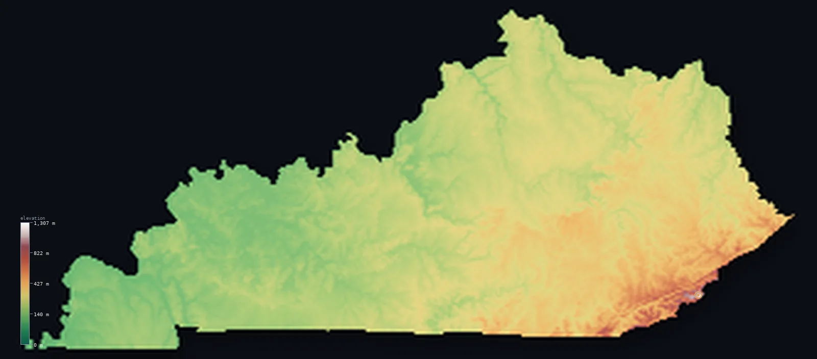
Kentucky’s highest point is Black Mountain at 4,144 ft (1,263 m); its lowest is Mississippi River at 256 ft (78 m); the mean elevation is 840 ft (256 m).
- Highest point📚
- 4,144 ft1,263 m
- Black Mountain.
- Lowest point📚
- 256 ft78 m
- Mississippi River.
- Mean elevation⚙
- 840 ft256 m
- Computed from the GLO-30 surface model.
- Median elevation⚙
- 804 ft245 m
- Half of Kentucky lies below this height.
- Elevation range📚
- 3,888 ft1,185 m
- From 78 m to Black Mountain's 1263 m.
- Above 1,000 m (3,281 ft)⚙
- <1%
- The state's higher ground.
- Official area📚
- 40,408 mi²104,656 km²
- Kentucky.
Kentucky at a glance
Mammoth Cave in central Kentucky is the longest cave system in the world, with over 640 km explored.
source ↗Black Mountain, the high point, sits in the heart of Appalachian coal country.
source ↗Kentucky's karst landscape is riddled with sinkholes, springs and underground rivers.
source ↗The Bluegrass region's limestone soils are prized for raising thoroughbred horses.
source ↗Kentucky is bordered by more rivers than almost any other state, wrapped by the Ohio and Mississippi.
source ↗
Elevation profile of Kentucky
The largest share of land, 41%, falls in the 200–300 m band, and 97% of the territory lies below 500 m (1,640 ft).
- below 500 m (1,640 ft)97%
- 500–1,000 m3%
- 1,000–2,000 m<1%
Highest and lowest points
The highest point of Kentucky, Black Mountain, 1,263 m, in the Cumberland Mountains on the Virginia border - coal country, its summit crowned not with wilderness but with radio towers above the old mining valleys.
source ↗Highest peaks of Kentucky
| Peak | Elevation | Range | Note |
|---|---|---|---|
| Black Mountain↗ | 4,144 ft1,263 m | Cumberland Mountains | Highest point of Kentucky, on the Virginia line. |
| Big Black Mountain ridge↗ | 4,134 ft1,260 m | Cumberland Mountains | The high ridge around the summit. |
| Pine Mountain↗ | 3,330 ft1,015 m | Cumberland Mountains | A long straight ridge of the eastern coalfields. |
| Cumberland Mountain↗ | 3,281 ft1,000 m | Cumberland Mountains | A ridge along the Virginia-Tennessee corner. |
| Log Mountain↗ | 3,199 ft975 m | Cumberland Mountains | A high ridge of the southeastern mountains. |
Terrain regions of Kentucky
Mammoth Cave in central Kentucky is the longest cave system in the world, with over 640 km explored. ↗
The eastern mountains
↗Eastern Kentucky is Appalachian coal country - the rugged Cumberland Mountains and the deeply dissected Cumberland Plateau, a maze of steep ridges and narrow ho
The Bluegrass and central Kentucky
↗Central Kentucky is the rolling Bluegrass region, a gently undulating country of rich limestone soils, horse farms and the karst landscape of Mammoth Cave, the
The western plateaus and Mississippi lowlands
↗Western Kentucky is lower, gentler country - the Pennyroyal Plateau, the Western Coalfields, and finally the flat Mississippi alluvial plain of the Jackson Purc
The eastern mountains
the eastEastern Kentucky is Appalachian coal country - the rugged Cumberland Mountains and the deeply dissected Cumberland Plateau, a maze of steep ridges and narrow hollows. Here Black Mountain (1,263 m) on the Virginia line is the state's highest point, in a landscape shaped as much by mining as by nature.
The Bluegrass and central Kentucky
the centreCentral Kentucky is the rolling Bluegrass region, a gently undulating country of rich limestone soils, horse farms and the karst landscape of Mammoth Cave, the longest cave system in the world. This is the settled heart of the state around Lexington and Louisville.
The western plateaus and Mississippi lowlands
the westWestern Kentucky is lower, gentler country - the Pennyroyal Plateau, the Western Coalfields, and finally the flat Mississippi alluvial plain of the Jackson Purchase, dropping to the state's lowest point where the Mississippi River leaves at 78 m.
City elevations in Kentucky
| City | Population | Elevation |
|---|---|---|
| Louisville | 624,444 | 463 ft141 m |
| Lexington | 320,347 | 978 ft298 m |
| Meads | 288,649 | 617 ft188 m |
| Bowling Green | 63,616 | 535 ft163 m |
| Owensboro | 59,042 | 397 ft121 m |
| Covington | 40,997 | 525 ft160 m |
| Hopkinsville | 32,205 | 538 ft164 m |
| Elizabethtown | 29,678 | 725 ft221 m |
| Paducah | 24,864 | 344 ft105 m |
| Madisonville | 19,539 | 469 ft143 m |
Elevation sampled at each city centre from the Copernicus GLO-30 model. Cities and population from GeoNames (CC-BY 4.0).
Kentucky in comparison
Kentucky's terrain rises 3,888 ft (1,185 m) from Mississippi River (256 ft (78 m)) to Black Mountain — about 13% of the height of Mount Everest, the world's highest point at 29,032 ft (8,849 m).
Frequently asked questions
What is the highest point in Kentucky?
- Black Mountain, 4,144 ft (1,263 m).
What is the average elevation of Kentucky?
- About 230 m according to the USGS; this page also reports the area-weighted mean computed from the Copernicus GLO-30 model, 840 ft (256 m).
What is the lowest point in Kentucky?
- Mississippi River, 256 ft (78 m).
Mammoth Cave in central Kentucky is the longest cave system in the world?
- Mammoth Cave in central Kentucky is the longest cave system in the world, with over 640 km explored.
Where is the highest ground in Kentucky?
- Eastern Kentucky is Appalachian coal country - the rugged Cumberland Mountains and the deeply dissected Cumberland Plateau, a maze of steep ridges and narrow hollows. Here Black Mountain (1,263 m) on
Is this a topographic, relief, contour, or elevation map of Kentucky?
- They describe the same thing - terrain height. This page renders Kentucky's actual elevation surface in interactive 3D (a relief or topographic view) and reports the statistics computed from it; a contour map shows the same data as lines of equal height.
About this map
The terrain is rendered from the Copernicus GLO-30 digital elevation model (ESA), masked to the US-KY boundary from geoBoundaries (gbOpen). Elevation statistics are computed directly from the model; peak names and researched facts are sourced and cited. See the methodology for the full pipeline.
Our area-weighted mean, computed from the Copernicus GLO-30 model, is 840 ft (256 m); the figure commonly cited elsewhere is 755 ft (230 m) (U.S. Geological Survey). Kentucky's mean elevation is about 230 m; the page reports the area-weighted figure computed from the Copernicus GLO-30 model.
Surveyed national figures: official area · high point.
Rendered from Copernicus GLO-30 (ESA, 2021 release), boundaries from geoBoundaries. Generated 2026-07-14.