Missouri Elevation Map
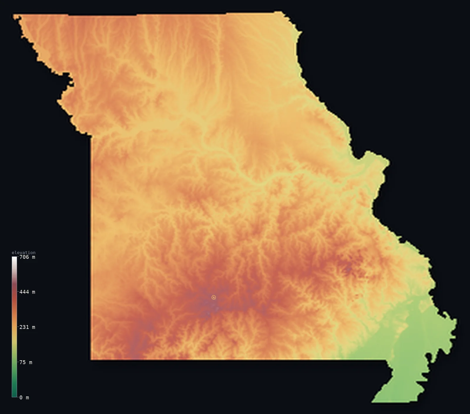
Missouri’s highest point is Taum Sauk Mountain at 1,772 ft (540 m); its lowest is St. Francis River at 230 ft (70 m); the mean elevation is 860 ft (262 m).
- Highest point📚
- 1,772 ft540 m
- Taum Sauk Mountain.
- Lowest point📚
- 230 ft70 m
- St. Francis River.
- Mean elevation⚙
- 860 ft262 m
- Computed from the GLO-30 surface model.
- Median elevation⚙
- 856 ft261 m
- Half of Missouri lies below this height.
- Elevation range📚
- 1,542 ft470 m
- From 70 m to Taum Sauk Mountain's 540 m.
- Official area📚
- 69,707 mi²180,540 km²
- Missouri.
Missouri at a glance
Taum Sauk Mountain is built from volcanic rock over 1.4 billion years old, among the oldest exposed in North America.
source ↗Missouri is one of the most cave-rich states, nicknamed the 'Cave State' for its thousands of Ozark caves.
source ↗The Missouri and Mississippi rivers meet just north of St. Louis.
source ↗The 1811-12 New Madrid earthquakes in Missouri's Bootheel were among the strongest ever recorded in North America.
source ↗The Ozarks are not folded mountains but an ancient uplifted and eroded dome.
source ↗
Elevation profile of Missouri
The largest share of land, 29%, falls in the 250–300 m band, and >99% of the territory lies below 500 m (1,640 ft).
- below 500 m (1,640 ft)>99%
- 500–1,000 m<1%
Highest and lowest points
The highest point of Missouri, Taum Sauk Mountain, 540 m, in the St. Francois Mountains of the Ozarks - built from some of the oldest exposed volcanic rock in the country, over 1.4 billion years old.
source ↗Highest peaks of Missouri
| Peak | Elevation | Range | Note |
|---|---|---|---|
| Taum Sauk Mountain↗ | 1,772 ft540 m | St. Francois Mountains | Highest point of Missouri, ancient volcanic rock. |
| Buford Mountain↗ | 1,755 ft535 m | St. Francois Mountains | One of the highest points in the Ozarks. |
| Proffit Mountain↗ | 1,719 ft524 m | St. Francois Mountains | A high point near Taum Sauk, site of a reservoir. |
| Bell Mountain↗ | 1,690 ft515 m | St. Francois Mountains | A high knob of the St. Francois range. |
| Wildcat Mountain↗ | 1,683 ft513 m | St. Francois Mountains | A high summit of the Ozark volcanic core. |
Terrain regions of Missouri
Taum Sauk Mountain is built from volcanic rock over 1.4 billion years old, among the oldest exposed in North America. ↗
The Ozark Highlands
↗Southern Missouri is dominated by the Ozarks, a broad, ancient, forested dome of hills, deep valleys, caves and clear rivers. At its core the St. Francois Mount
The plains and prairies
↗Northern and western Missouri is glaciated till plains and prairie - gently rolling farmland north of the Missouri River, part of the Central Lowlands, and the
The river lowlands and Bootheel
↗Missouri is framed and split by two great rivers, the Missouri and the Mississippi, which meet near St. Louis. In the far southeast the flat Bootheel is part of
The Ozark Highlands
the southSouthern Missouri is dominated by the Ozarks, a broad, ancient, forested dome of hills, deep valleys, caves and clear rivers. At its core the St. Francois Mountains expose some of the oldest volcanic rock in North America, rising to Taum Sauk Mountain (540 m), the state high point. Nearby, the St. Francis River carves down to the state's lowest point.
The plains and prairies
the north and westNorthern and western Missouri is glaciated till plains and prairie - gently rolling farmland north of the Missouri River, part of the Central Lowlands, and the Osage Plains sloping toward Kansas. This is flatter, more open country than the rugged south.
The river lowlands and Bootheel
the rivers and southeastMissouri is framed and split by two great rivers, the Missouri and the Mississippi, which meet near St. Louis. In the far southeast the flat Bootheel is part of the Mississippi alluvial plain - drained swampland, the lowest and flattest corner of the state.
City elevations in Missouri
| City | Population | Elevation |
|---|---|---|
| Kansas City | 475,378 | 906 ft276 m |
| St. Louis | 279,695 | 469 ft143 m |
| Springfield | 170,188 | 1,302 ft397 m |
| Columbia | 129,330 | 719 ft219 m |
| Saint Joseph | 76,780 | 899 ft274 m |
| Joplin | 51,818 | 1,004 ft306 m |
| Quincy | 40,780 | 577 ft176 m |
| Cape Girardeau | 39,462 | 358 ft109 m |
| Wentzville | 35,603 | 633 ft193 m |
| Sedalia | 21,516 | 915 ft279 m |
Elevation sampled at each city centre from the Copernicus GLO-30 model. Cities and population from GeoNames (CC-BY 4.0).
Missouri in comparison
Missouri's terrain rises 1,542 ft (470 m) from St. Francis River (230 ft (70 m)) to Taum Sauk Mountain — about 5% of the height of Mount Everest, the world's highest point at 29,032 ft (8,849 m).
Frequently asked questions
What is the highest point in Missouri?
- Taum Sauk Mountain, 1,772 ft (540 m).
What is the average elevation of Missouri?
- About 240 m according to the USGS; this page also reports the area-weighted mean computed from the Copernicus GLO-30 model, 860 ft (262 m).
What is the lowest point in Missouri?
- St. Francis River, 230 ft (70 m).
Taum Sauk Mountain is built from volcanic rock over 1.4 billion years old?
- Taum Sauk Mountain is built from volcanic rock over 1.4 billion years old, among the oldest exposed in North America.
Where is the highest ground in Missouri?
- Southern Missouri is dominated by the Ozarks, a broad, ancient, forested dome of hills, deep valleys, caves and clear rivers. At its core the St. Francois Mountains expose some of the oldest volcanic
Is this a topographic, relief, contour, or elevation map of Missouri?
- They describe the same thing - terrain height. This page renders Missouri's actual elevation surface in interactive 3D (a relief or topographic view) and reports the statistics computed from it; a contour map shows the same data as lines of equal height.
About this map
The terrain is rendered from the Copernicus GLO-30 digital elevation model (ESA), masked to the US-MO boundary from geoBoundaries (gbOpen). Elevation statistics are computed directly from the model; peak names and researched facts are sourced and cited. See the methodology for the full pipeline.
Our area-weighted mean, computed from the Copernicus GLO-30 model, is 860 ft (262 m); the figure commonly cited elsewhere is 787 ft (240 m) (U.S. Geological Survey). Missouri's mean elevation is about 240 m; the page reports the area-weighted figure computed from the Copernicus GLO-30 model.
Surveyed national figures: official area · high point.
Rendered from Copernicus GLO-30 (ESA, 2021 release), boundaries from geoBoundaries. Generated 2026-07-14.