Oklahoma Elevation Map
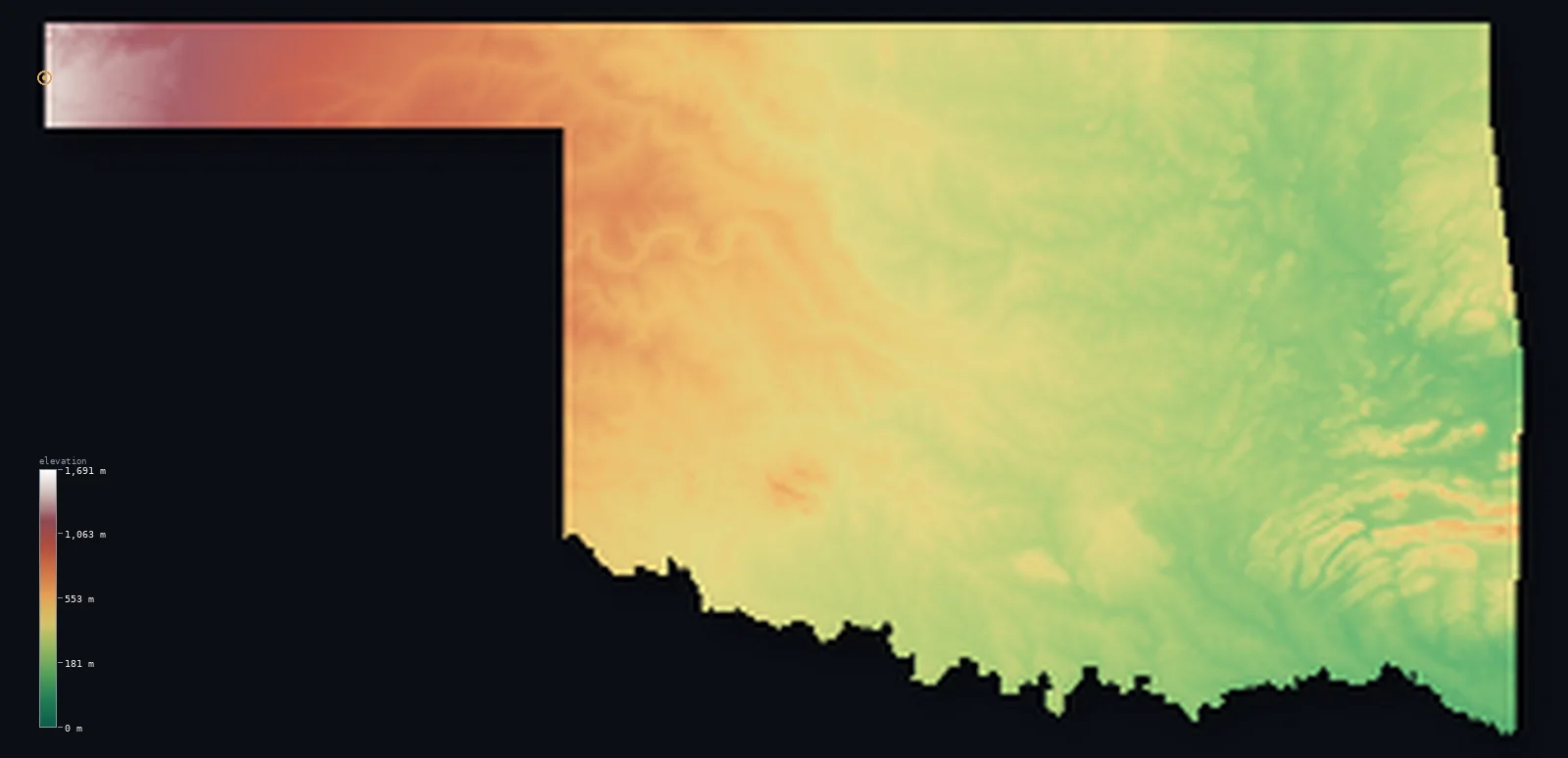
Oklahoma’s highest point is Black Mesa at 4,974 ft (1,516 m); its lowest is Little River at 289 ft (88 m); the mean elevation is 1,293 ft (394 m).
- Highest point📚
- 4,974 ft1,516 m
- Black Mesa.
- Lowest point📚
- 289 ft88 m
- Little River.
- Mean elevation⚙
- 1,293 ft394 m
- Computed from the GLO-30 surface model.
- Median elevation⚙
- 1,066 ft325 m
- Half of Oklahoma lies below this height.
- Elevation range📚
- 4,685 ft1,428 m
- From 88 m to Black Mesa's 1516 m.
- Above 1,000 m (3,281 ft)⚙
- 4%
- The state's higher ground.
- Official area📚
- 69,899 mi²181,037 km²
- Oklahoma.
Oklahoma at a glance
Black Mesa, the high point, is over a kilometre higher than most of Oklahoma and sits at a three-state corner.
source ↗Oklahoma's Black Mesa is capped by an ancient lava flow, unique in the state.
source ↗The state spans nearly 1,400 m of relief, from High Plains mesa to eastern river bottoms.
source ↗Cavanal Hill near Poteau is locally promoted as the 'world's highest hill' at just under mountain height.
source ↗Oklahoma has more man-made lakes than any other state, over 200 of them.
source ↗
Elevation profile of Oklahoma
The largest share of land, 30%, falls in the 200–300 m band, and 78% of the territory lies below 500 m (1,640 ft).
- below 500 m (1,640 ft)78%
- 500–1,000 m18%
- 1,000–2,000 m4%
Highest and lowest points
The highest point of Oklahoma, Black Mesa, 1,516 m, at the very tip of the panhandle where Oklahoma, Colorado and New Mexico meet - the flat top of an ancient lava flow, utterly unlike the rest of the state.
source ↗Highest peaks of Oklahoma
| Peak | Elevation | Range | Note |
|---|---|---|---|
| Black Mesa↗ | 4,974 ft1,516 m | High Plains (panhandle) | Highest point of Oklahoma, a lava-capped mesa. |
| Rich Mountain↗ | 2,680 ft817 m | Ouachita Mountains | A high peak on the Arkansas border in the southeast. |
| Kiamichi Mountain↗ | 2,592 ft790 m | Ouachita Mountains | A high ridge of the southeastern Ouachitas. |
| Buffalo Mountain↗ | 2,001 ft610 m | Sans Bois Mountains | A high point of the eastern hills. |
| Cavanal Hill↗ | 2,001 ft610 m | Sans Bois Mountains | Locally billed as the 'world's highest hill'. |
Terrain regions of Oklahoma
Black Mesa, the high point, is over a kilometre higher than most of Oklahoma and sits at a three-state corner. ↗
The panhandle and High Plains
↗At the far western tip of the Oklahoma panhandle, the land climbs onto the High Plains and reaches Black Mesa (1,516 m), a flat lava-capped mesa at the Colorado
The central plains and hills
↗Central Oklahoma is rolling prairie and low hills - the Osage Plains, the red-earth country, and scattered ancient ranges like the Wichita and Arbuckle mountain
The eastern mountains and lowlands
↗Eastern Oklahoma is greener and more rugged - the Ouachita Mountains with their east-west ridges in the southeast, the Ozark edge in the northeast, and the low
The panhandle and High Plains
the far westAt the far western tip of the Oklahoma panhandle, the land climbs onto the High Plains and reaches Black Mesa (1,516 m), a flat lava-capped mesa at the Colorado-New Mexico corner - the highest and driest ground in the state, over a kilometre above the rest.
The central plains and hills
the centreCentral Oklahoma is rolling prairie and low hills - the Osage Plains, the red-earth country, and scattered ancient ranges like the Wichita and Arbuckle mountains, worn stumps rising from the plains near the state's centre and south.
The eastern mountains and lowlands
the eastEastern Oklahoma is greener and more rugged - the Ouachita Mountains with their east-west ridges in the southeast, the Ozark edge in the northeast, and the low river valleys draining toward Arkansas, holding the state's lowest point on the Little River at 88 m.
City elevations in Oklahoma
| City | Population | Elevation |
|---|---|---|
| Oklahoma City | 681,054 | 1,207 ft368 m |
| Tulsa | 413,066 | 728 ft222 m |
| Lawton | 96,655 | 1,112 ft339 m |
| Enid | 51,776 | 1,243 ft379 m |
| Stillwater | 48,967 | 906 ft276 m |
| Muskogee | 38,456 | 607 ft185 m |
| Bartlesville | 36,595 | 709 ft216 m |
| Shawnee | 31,286 | 1,063 ft324 m |
| Ardmore | 25,176 | 876 ft267 m |
| Ponca City | 24,758 | 1,014 ft309 m |
Elevation sampled at each city centre from the Copernicus GLO-30 model. Cities and population from GeoNames (CC-BY 4.0).
Oklahoma in comparison
Oklahoma's terrain rises 4,685 ft (1,428 m) from Little River (289 ft (88 m)) to Black Mesa — about 16% of the height of Mount Everest, the world's highest point at 29,032 ft (8,849 m).
Frequently asked questions
What is the highest point in Oklahoma?
- Black Mesa, 4,974 ft (1,516 m).
What is the average elevation of Oklahoma?
- About 300 m according to the USGS; this page also reports the area-weighted mean computed from the Copernicus GLO-30 model, 1,293 ft (394 m).
What is the lowest point in Oklahoma?
- Little River, 289 ft (88 m).
Black Mesa?
- Black Mesa, the high point, is over a kilometre higher than most of Oklahoma and sits at a three-state corner.
Where is the highest ground in Oklahoma?
- At the far western tip of the Oklahoma panhandle, the land climbs onto the High Plains and reaches Black Mesa (1,516 m), a flat lava-capped mesa at the Colorado-New Mexico corner - the highest and dri
Is this a topographic, relief, contour, or elevation map of Oklahoma?
- They describe the same thing - terrain height. This page renders Oklahoma's actual elevation surface in interactive 3D (a relief or topographic view) and reports the statistics computed from it; a contour map shows the same data as lines of equal height.
About this map
The terrain is rendered from the Copernicus GLO-30 digital elevation model (ESA), masked to the US-OK boundary from geoBoundaries (gbOpen). Elevation statistics are computed directly from the model; peak names and researched facts are sourced and cited. See the methodology for the full pipeline.
Our area-weighted mean, computed from the Copernicus GLO-30 model, is 1,293 ft (394 m); the figure commonly cited elsewhere is 984 ft (300 m) (U.S. Geological Survey). Oklahoma's mean elevation is about 300 m; the page reports the area-weighted figure computed from the Copernicus GLO-30 model.
Surveyed national figures: official area · high point.
Rendered from Copernicus GLO-30 (ESA, 2021 release), boundaries from geoBoundaries. Generated 2026-07-14.