Texas Elevation Map
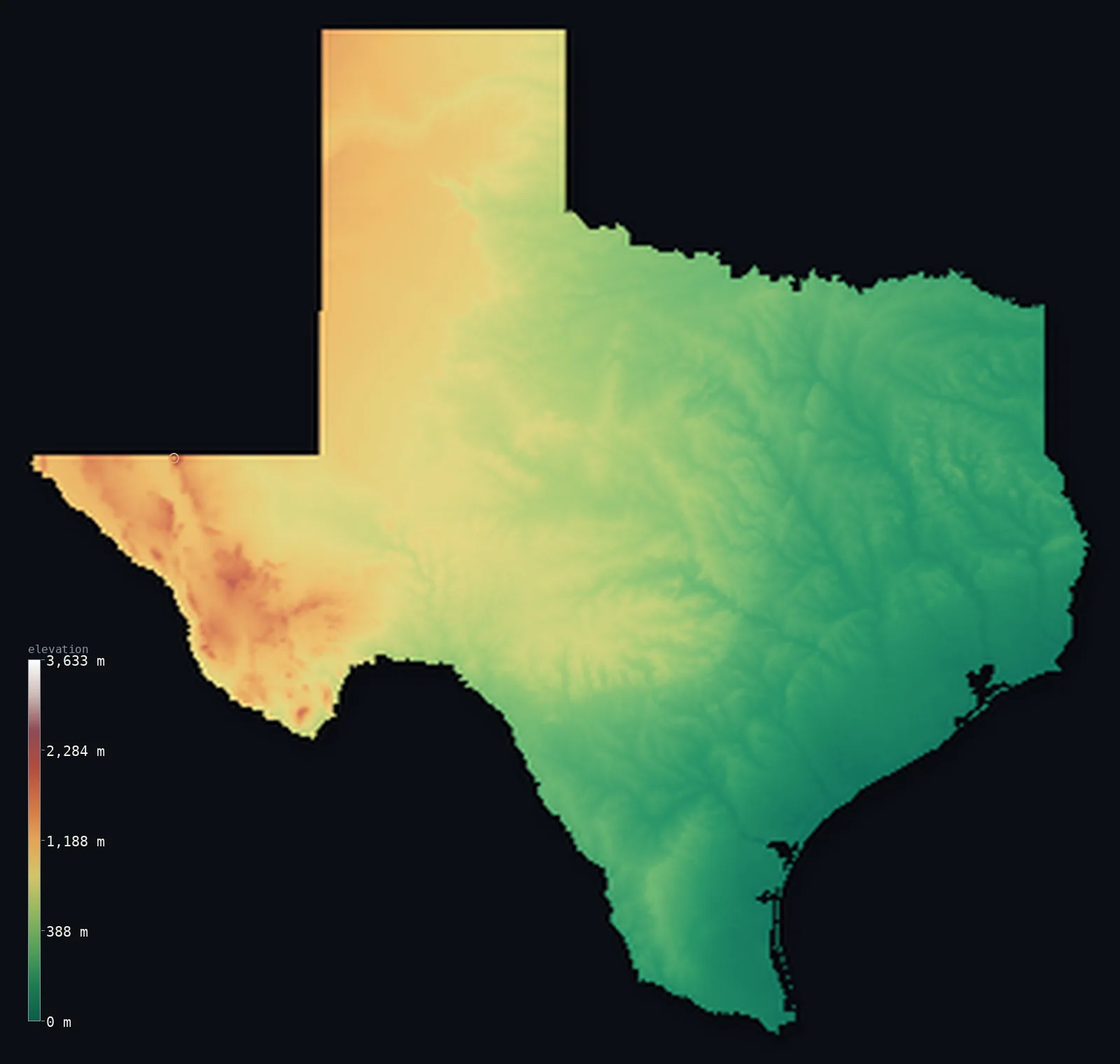
Texas’s highest point is Guadalupe Peak at 8,750 ft (2,667 m); its lowest is Gulf of Mexico at 0 ft (0 m); the mean elevation is 1,657 ft (505 m).
- Highest point📚
- 8,750 ft2,667 m
- Guadalupe Peak, in the mountains of far West Texas.
- Lowest point📚
- 0 ft0 m
- Sea level on the Gulf of Mexico coast.
- Mean elevation⚙
- 1,657 ft505 m
- Computed from the GLO-30 surface model across the state.
- Median elevation⚙
- 1,332 ft406 m
- Half of Texas lies below this height.
- Elevation range📚
- 8,750 ft2,667 m
- From the Gulf coast to Guadalupe Peak's 2,667 m.
- Above 1,000 m (3,281 ft)⚙
- 16%
- The mountains and high plains of West Texas.
- Official area📚
- 268,596 mi²695,662 km²
- A vast state rising from the humid Gulf coast to western desert mountains.
Texas at a glance
Texas's high point, Guadalupe Peak at 2,667 m, is far higher than most people expect - taller than any point in 30 other states.
source ↗The Guadalupe Mountains are an uplifted fossil reef, once a barrier reef in an ancient sea.
source ↗The Llano Estacado of the panhandle is one of the largest and flattest mesas in North America.
source ↗El Paso, in the far west, sits over a kilometre higher than the rest of populous Texas.
source ↗Texas spans humid Gulf marsh in the east and true desert mountains in the west.
source ↗
Elevation profile of Texas
The largest share of land, 37%, falls in the 0–200 m band, and 55% of the territory lies below 500 m (1,640 ft).
- below 500 m (1,640 ft)55%
- 500–1,000 m29%
- 1,000–2,000 m16%
- above 2,000 m (6,562 ft)<1%
Highest and lowest points
The highest point of Texas, Guadalupe Peak, 2,667 m, in the Guadalupe Mountains of far West Texas near the New Mexico border - higher than most people expect of Texas. The range is an uplifted fossil reef at the edge of the Chihuahuan Desert, and the peak is reached by an 8.5-mile round-trip trail.
source ↗Highest peaks of Texas
| Peak | Elevation | Range | Note |
|---|---|---|---|
| Guadalupe Peak↗ | 8,750 ft2,667 m | Guadalupe Mountains | Highest point of Texas, in the far west near New Mexico. |
| Bush Mountain↗ | 8,652 ft2,637 m | Guadalupe Mountains | The second-highest peak in Texas, beside Guadalupe Peak. |
| Shumard Peak↗ | 8,570 ft2,612 m | Guadalupe Mountains | The third-highest summit in the Guadalupe Mountains. |
| Mount Livermore↗ | 8,379 ft2,554 m | Davis Mountains | The highest peak of the volcanic Davis Mountains in West Texas. |
| El Capitan↗ | 8,084 ft2,464 m | Guadalupe Mountains | The dramatic sheer-faced landmark peak at the southern end of the range. |
Terrain regions of Texas
Texas's high point, Guadalupe Peak at 2,667 m, is far higher than most people expect - taller than any point in 30 other states. ↗
The Gulf coastal plain
↗The low, humid, gently sloping plain along the Gulf of Mexico and up the eastern part of the state, holding Houston and the coast.
The interior plains and Hill Country
↗The rolling prairies and the rugged Edwards Plateau and Hill Country of central Texas, bounded by the Balcones Escarpment.
The high plains and western mountains
↗The flat, high Llano Estacado of the panhandle and the desert basins and ranges of far West Texas, including the Guadalupe and Davis mountains.
The Gulf coastal plain
the east and coastEastern and coastal Texas is a broad, low plain sloping gently to the Gulf of Mexico. Humid and wooded in the east, it flattens toward the coast into marsh, bay and barrier island at sea level. This is the lowest and most populous part of the state, holding Houston and the port cities, and it grades inland into rolling prairie.
The plains and Hill Country
the centre and northBehind the coastal plain the land steps up at the Balcones Escarpment into central Texas - the limestone Edwards Plateau and the rugged, spring-fed Hill Country around Austin and San Antonio. North of these stretch the North Central Plains and, in the panhandle, the dead-flat high tableland of the Llano Estacado, one of the largest mesas in North America.
The mountains of West Texas
the far westFar West Texas is a different world - the northern reach of the Chihuahuan Desert, a country of wide basins and isolated mountain ranges. Here rise the Guadalupe Mountains, an uplifted ancient reef carrying Guadalupe Peak (2,667 m), the highest point in the state, along with the volcanic Davis Mountains and the rugged country of Big Bend on the Rio Grande.
City elevations in Texas
| City | Population | Elevation |
|---|---|---|
| Houston | 2,314,157 | 46 ft14 m |
| San Antonio | 1,526,656 | 663 ft202 m |
| Dallas | 1,326,087 | 436 ft133 m |
| AustinAustin, the capital, sits on the Balcones Escarpment where the coastal plain meets the Hill Country in central Texas. ↗ | 974,447 | 505 ft154 m |
| El PasoEl Paso lies in the far western corner among desert mountains, at about 1,140 m - far higher than the rest of the state. ↗ | 678,815 | 3,730 ft1,137 m |
| Heroica Matamoros | 510,739 | 46 ft14 m |
| Corpus Christi | 316,239 | 16 ft5 m |
| Laredo | 256,153 | 427 ft130 m |
| Lubbock | 249,042 | 3,205 ft977 m |
| Amarillo | 198,645 | 3,671 ft1,119 m |
Elevation sampled at each city centre from the Copernicus GLO-30 model. Cities and population from GeoNames (CC-BY 4.0).
Texas in comparison
Texas's terrain rises 8,750 ft (2,667 m) from sea level to Guadalupe Peak — about 30% of the height of Mount Everest, the world's highest point at 29,032 ft (8,849 m).
Frequently asked questions
What is the highest point in Texas?
- Guadalupe Peak, 8,750 ft (2,667 m), in the Guadalupe Mountains of far West Texas.
What is the average elevation of Texas?
- About 520 m according to the USGS; this page also reports the area-weighted mean computed from the Copernicus GLO-30 model, 1,657 ft (505 m).
What is the lowest point in Texas?
- Sea level, along the Gulf of Mexico coast.
Is Texas flat?
- The coast and panhandle are very flat, but the land rises west to the Hill Country and true desert mountains, reaching 2,667 m at Guadalupe Peak.
Where are the mountains in Texas?
- In the far west - the Guadalupe Mountains (with the state high point), the Davis Mountains, and the Chisos of Big Bend.
Is this a topographic, relief, contour, or elevation map of Texas?
- They describe the same thing - terrain height. This page renders Texas's actual elevation surface in interactive 3D (a relief or topographic view) and reports the statistics computed from it; a contour map shows the same data as lines of equal height.
About this map
The terrain is rendered from the Copernicus GLO-30 digital elevation model (ESA), masked to the US-TX boundary from geoBoundaries (gbOpen). Elevation statistics are computed directly from the model; peak names and researched facts are sourced and cited. See the methodology for the full pipeline.
Our area-weighted mean, computed from the Copernicus GLO-30 model, is 1,657 ft (505 m); the figure commonly cited elsewhere is 1,706 ft (520 m) (U.S. Geological Survey). Texas rises gradually from the Gulf coast in the east to the high plains and mountains of the far west, giving a moderate mean of about 520 m; the page reports the area-weighted figure computed from the Copernicus GLO-30 model.
Surveyed national figures: official area · high point.
Rendered from Copernicus GLO-30 (ESA, 2021 release), boundaries from geoBoundaries. Generated 2026-07-13.