Louisiana Elevation Map
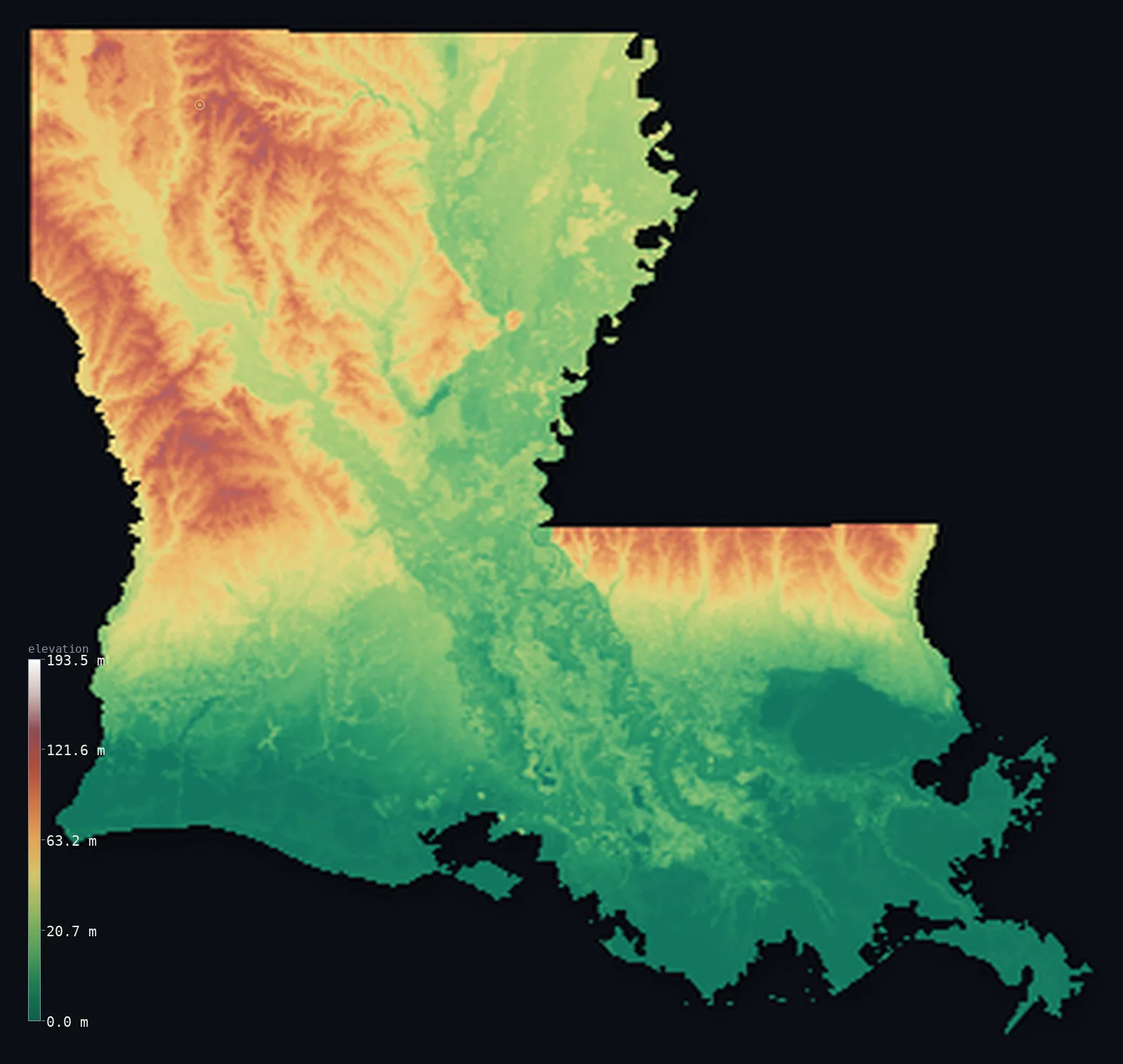
Louisiana’s highest point is Driskill Mountain at 535 ft (163 m); its lowest is New Orleans (below sea level) at −7 ft (−2 m); the mean elevation is 108 ft (32.8 m).
- Highest point📚
- 535 ft163 m
- Driskill Mountain.
- Lowest point📚
- −7 ft−2 m
- New Orleans (below sea level).
- Mean elevation⚙
- 108 ft32.8 m
- Computed from the GLO-30 surface model.
- Median elevation⚙
- 76 ft23.1 m
- Half of Louisiana lies below this height.
- Elevation range📚
- 541 ft165 m
- From −7 ft (−2 m) to Driskill Mountain's 163 m.
- Above 50 m (164 ft)⚙
- 29%
- The state's higher ground.
- Official area📚
- 52,378 mi²135,659 km²
- Louisiana.
Louisiana at a glance
Much of the land around New Orleans lies below sea level, protected by an extensive levee system.
source ↗Louisiana is the flattest and one of the lowest states, its mean elevation only about 30 m.
source ↗The Mississippi Delta wetlands are among the largest and fastest-changing on Earth.
source ↗Louisiana is losing coastal wetland to the Gulf at one of the fastest rates in the world.
source ↗Even Louisiana's high point, Driskill Mountain, is a low pine hill of just 163 m.
source ↗
Elevation profile of Louisiana
The largest share of land, 42%, falls in the 0–20 m band, and 100% of the territory lies below 500 m (1,640 ft).
- below sea level4%
- 0–10 m (0–33 ft)28%
- 10–50 m (33–164 ft)40%
- above 50 m (164 ft)29%
Highest and lowest points
The highest point of Louisiana, Driskill Mountain, just 163 m, a low pine-covered hill in the north - notable mostly for a state that is otherwise the lowest and flattest in the South, with land near New Orleans sitting below sea level.
source ↗Highest peaks of Louisiana
| Peak | Elevation | Range | Note |
|---|---|---|---|
| Driskill Mountain↗ | 535 ft163 m | North Louisiana hills | Highest point of Louisiana, a low pine hill. |
| Mount Zion↗ | 525 ft160 m | North Louisiana hills | A high point beside Driskill Mountain. |
| Kisatchie highpoint↗ | 394 ft120 m | Kisatchie Hills | High ground of the Kisatchie National Forest. |
| Sligo Hills↗ | 361 ft110 m | North Louisiana hills | Low hills of the northwest. |
| Tunica Hills↗ | 295 ft90 m | Tunica Hills | Loess bluffs above the Mississippi in the southeast. |
Terrain regions of Louisiana
Much of the land around New Orleans lies below sea level, protected by an extensive levee system. ↗
The northern hills
↗Northern Louisiana holds the state's only real high ground - low, rolling, pine-covered hills, where Driskill Mountain (163 m) is the modest state high point. T
The Mississippi floodplain and prairies
↗Central and eastern Louisiana is dominated by the vast floodplain of the Mississippi River, a flat expanse of rich alluvial farmland, bayous and old river chann
The coast, delta and wetlands
↗Southern Louisiana is one of the largest wetland regions on Earth - the great Mississippi Delta, a maze of swamp, marsh, bayou and barrier island slowly sinking
The northern hills
the northNorthern Louisiana holds the state's only real high ground - low, rolling, pine-covered hills, where Driskill Mountain (163 m) is the modest state high point. This is upland pine and hardwood country, cut by rivers draining south, higher and drier than the coast.
The Mississippi floodplain and prairies
the centre and eastCentral and eastern Louisiana is dominated by the vast floodplain of the Mississippi River, a flat expanse of rich alluvial farmland, bayous and old river channels, flanked by the loess bluffs and, to the southwest, the flat coastal prairies.
The coast, delta and wetlands
the southSouthern Louisiana is one of the largest wetland regions on Earth - the great Mississippi Delta, a maze of swamp, marsh, bayou and barrier island slowly sinking into the Gulf. Around New Orleans, much of the land lies below sea level, held back by levees, marking the state's - and one of the nation's - lowest points.
City elevations in Louisiana
| City | Population | Elevation |
|---|---|---|
| New Orleans | 362,701 | 20 ft6 m |
| Baton Rouge | 227,470 | 56 ft17 m |
| Shreveport | 187,593 | 161 ft49 m |
| Lafayette | 121,374 | 43 ft13 m |
| Lake Charles | 76,070 | 20 ft6 m |
| Monroe | 49,598 | 79 ft24 m |
| Alexandria | 47,889 | 85 ft26 m |
| Houma | 34,287 | 16 ft5 m |
| Slidell | 27,942 | 13 ft4 m |
| Vicksburg | 23,131 | 240 ft73 m |
Elevation sampled at each city centre from the Copernicus GLO-30 model. Cities and population from GeoNames (CC-BY 4.0).
Louisiana in comparison
Louisiana's terrain rises 541 ft (165 m) from New Orleans (below sea level), 7 ft (2 m) below sea level to Driskill Mountain — about 2% of the height of Mount Everest, the world's highest point at 29,032 ft (8,849 m).
Frequently asked questions
What is the highest point in Louisiana?
- Driskill Mountain, 535 ft (163 m).
What is the average elevation of Louisiana?
- About 30 m according to the USGS; this page also reports the area-weighted mean computed from the Copernicus GLO-30 model, 108 ft (32.8 m).
What is the lowest point in Louisiana?
- New Orleans (below sea level), −7 ft (−2 m).
Much of the land around New Orleans lies below sea level?
- Much of the land around New Orleans lies below sea level, protected by an extensive levee system.
Where is the highest ground in Louisiana?
- Northern Louisiana holds the state's only real high ground - low, rolling, pine-covered hills, where Driskill Mountain (163 m) is the modest state high point. This is upland pine and hardwood country,
Is this a topographic, relief, contour, or elevation map of Louisiana?
- They describe the same thing - terrain height. This page renders Louisiana's actual elevation surface in interactive 3D (a relief or topographic view) and reports the statistics computed from it; a contour map shows the same data as lines of equal height.
About this map
The terrain is rendered from the Copernicus GLO-30 digital elevation model (ESA), masked to the US-LA boundary from geoBoundaries (gbOpen). Elevation statistics are computed directly from the model; peak names and researched facts are sourced and cited. See the methodology for the full pipeline.
This map renders 122,105 km² across 43 landmasses of Louisiana. 3 smaller outlying parts — 36 km² in total — lie beyond the area shown here. Area statistics above count the full territory.
Our area-weighted mean, computed from the Copernicus GLO-30 model, is 108 ft (32.8 m); the figure commonly cited elsewhere is 98 ft (30 m) (U.S. Geological Survey). Louisiana's mean elevation is about 30 m; the page reports the area-weighted figure computed from the Copernicus GLO-30 model.
Surveyed national figures: official area · high point.
Rendered from Copernicus GLO-30 (ESA, 2021 release), boundaries from geoBoundaries. Generated 2026-07-14.