Mississippi Elevation Map
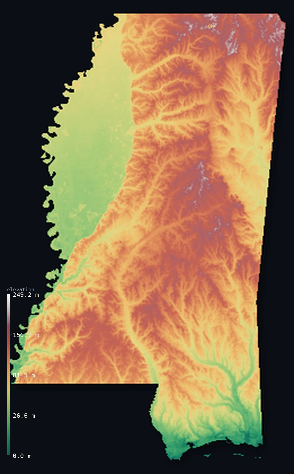
Mississippi’s highest point is Woodall Mountain at 807 ft (246 m); its lowest is Gulf of Mexico at 0 ft (0 m); the mean elevation is 305 ft (92.9 m).
- Highest point📚
- 807 ft246 m
- Woodall Mountain.
- Lowest point📚
- 0 ft0 m
- Gulf of Mexico.
- Mean elevation⚙
- 305 ft92.9 m
- Computed from the GLO-30 surface model.
- Median elevation⚙
- 311 ft94.9 m
- Half of Mississippi lies below this height.
- Elevation range📚
- 807 ft246 m
- From 0 m to Woodall Mountain's 246 m.
- Above 50 m (164 ft)⚙
- 79%
- The state's higher ground.
- Official area📚
- 48,432 mi²125,438 km²
- Mississippi.
Mississippi at a glance
Woodall Mountain, the high point, is only 246 m - among the lowest state high points in the nation.
source ↗The Mississippi Delta is one of the flattest and most fertile floodplains on Earth.
source ↗The Loess Bluffs along the Delta are steep hills built from Ice Age wind-blown silt.
source ↗Mississippi is one of the flattest and lowest states, its mean elevation only about 90 m.
source ↗The state is named for the great river that forms its entire western border.
source ↗
Elevation profile of Mississippi
The largest share of land, 17%, falls in the 100–120 m band, and 100% of the territory lies below 500 m (1,640 ft).
- 0–10 m (0–33 ft)1%
- 10–50 m (33–164 ft)19%
- above 50 m (164 ft)79%
Highest and lowest points
The highest point of Mississippi, Woodall Mountain, 246 m, a low wooded hill in the northeastern corner near the Tennessee line - a modest rise reflecting a state that is nearly all low coastal plain.
source ↗Highest peaks of Mississippi
| Peak | Elevation | Range | Note |
|---|---|---|---|
| Woodall Mountain↗ | 807 ft246 m | Northeast hills | Highest point of Mississippi, a low wooded hill. |
| Tishomingo highpoint↗ | 787 ft240 m | Northeast hills | High ground of the northeastern corner. |
| Pontotoc Ridge↗ | 623 ft190 m | North-central hills | A high cuesta ridge of north Mississippi. |
| Fall Line Hills↗ | 591 ft180 m | Central hills | High ground along the interior. |
| Loess Bluffs↗ | 492 ft150 m | Mississippi River bluffs | High wind-blown silt bluffs above the Delta. |
Terrain regions of Mississippi
Woodall Mountain, the high point, is only 246 m - among the lowest state high points in the nation. ↗
The northeastern hills
↗The highest ground in Mississippi is its northeastern corner, where low hills rise toward the Tennessee River and the edge of the Appalachian foothills. Here Wo
The interior plains and Delta
↗Most of Mississippi is low, gently rolling coastal plain - pine hills, prairies and river bottoms. Along the great river in the northwest lies the Mississippi D
The Piney Woods and Gulf coast
↗Southern Mississippi is the Piney Woods, a broad belt of low pine forest and farmland sloping to the Gulf of Mexico, ending in the low barrier islands and beach
The northeastern hills
the northeastThe highest ground in Mississippi is its northeastern corner, where low hills rise toward the Tennessee River and the edge of the Appalachian foothills. Here Woodall Mountain (246 m), a modest wooded rise, is the state's highest point - and even this is low by most states' standards.
The interior plains and Delta
the centre and northwestMost of Mississippi is low, gently rolling coastal plain - pine hills, prairies and river bottoms. Along the great river in the northwest lies the Mississippi Delta, a vast, flat, extraordinarily fertile floodplain of dark alluvial soil, fringed on its east by the steep Loess Bluffs of wind-blown silt.
The Piney Woods and Gulf coast
the southSouthern Mississippi is the Piney Woods, a broad belt of low pine forest and farmland sloping to the Gulf of Mexico, ending in the low barrier islands and beaches of the Mississippi Sound at sea level.
City elevations in Mississippi
| City | Population | Elevation |
|---|---|---|
| Jackson | 153,701 | 295 ft90 m |
| Gulfport | 71,856 | 23 ft7 m |
| Southaven | 52,589 | 328 ft100 m |
| Hattiesburg | 46,805 | 167 ft51 m |
| Meridian | 39,661 | 351 ft107 m |
| Tupelo | 35,680 | 285 ft87 m |
| Greenville | 32,156 | 135 ft41 m |
| Starkville | 25,366 | 338 ft103 m |
| Vicksburg | 23,131 | 240 ft73 m |
| Oxford | 22,314 | 512 ft156 m |
Elevation sampled at each city centre from the Copernicus GLO-30 model. Cities and population from GeoNames (CC-BY 4.0).
Mississippi in comparison
Mississippi's terrain rises 807 ft (246 m) from sea level to Woodall Mountain — about 3% of the height of Mount Everest, the world's highest point at 29,032 ft (8,849 m).
Frequently asked questions
What is the highest point in Mississippi?
- Woodall Mountain, 807 ft (246 m).
What is the average elevation of Mississippi?
- About 90 m according to the USGS; this page also reports the area-weighted mean computed from the Copernicus GLO-30 model, 305 ft (92.9 m).
What is the lowest point in Mississippi?
- Gulf of Mexico, 0 ft (0 m).
Woodall Mountain?
- Woodall Mountain, the high point, is only 246 m - among the lowest state high points in the nation.
Where is the highest ground in Mississippi?
- The highest ground in Mississippi is its northeastern corner, where low hills rise toward the Tennessee River and the edge of the Appalachian foothills. Here Woodall Mountain (246 m), a modest wooded
Is this a topographic, relief, contour, or elevation map of Mississippi?
- They describe the same thing - terrain height. This page renders Mississippi's actual elevation surface in interactive 3D (a relief or topographic view) and reports the statistics computed from it; a contour map shows the same data as lines of equal height.
About this map
The terrain is rendered from the Copernicus GLO-30 digital elevation model (ESA), masked to the US-MS boundary from geoBoundaries (gbOpen). Elevation statistics are computed directly from the model; peak names and researched facts are sourced and cited. See the methodology for the full pipeline.
Our area-weighted mean, computed from the Copernicus GLO-30 model, is 305 ft (92.9 m); the figure commonly cited elsewhere is 295 ft (90 m) (U.S. Geological Survey). Mississippi's mean elevation is about 90 m; the page reports the area-weighted figure computed from the Copernicus GLO-30 model.
Surveyed national figures: official area · high point.
Rendered from Copernicus GLO-30 (ESA, 2021 release), boundaries from geoBoundaries. Generated 2026-07-14.