Alabama Elevation Map
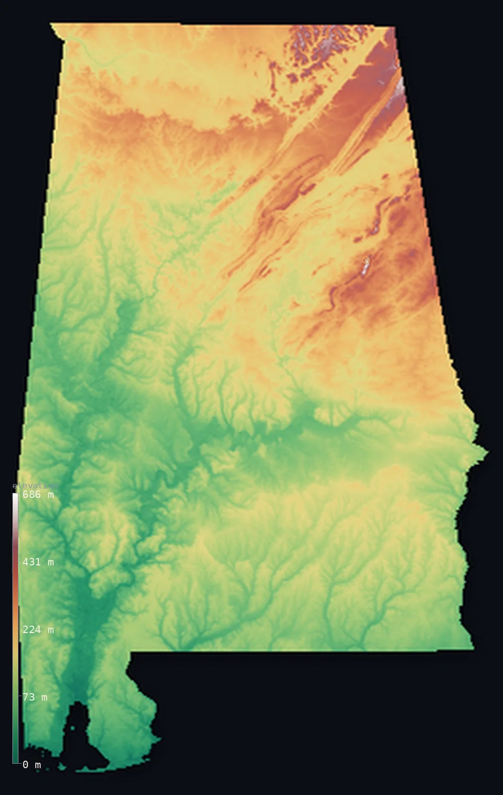
Alabama’s highest point is Cheaha Mountain at 2,411 ft (735 m); its lowest is Gulf of Mexico at 0 ft (0 m); the mean elevation is 476 ft (145 m).
- Highest point📚
- 2,411 ft735 m
- Cheaha Mountain.
- Lowest point📚
- 0 ft0 m
- Gulf of Mexico.
- Mean elevation⚙
- 476 ft145 m
- Computed from the GLO-30 surface model.
- Median elevation⚙
- 410 ft125 m
- Half of Alabama lies below this height.
- Elevation range📚
- 2,411 ft735 m
- From 0 m to Cheaha Mountain's 735 m.
- Official area📚
- 52,420 mi²135,767 km²
- Alabama.
Alabama at a glance
Cheaha Mountain marks the southern end of the Appalachian Mountains as they sink toward the Gulf.
source ↗Alabama's Black Belt is named for its dark, fertile prairie soil, not its landform.
source ↗The state has more navigable inland waterways than almost any other, over 2,000 km of rivers.
source ↗Alabama falls from 735 m in the Appalachians to sea level at Mobile Bay.
source ↗More than half the state is flat, low coastal plain despite its mountainous northeast.
source ↗
Elevation profile of Alabama
The largest share of land, 27%, falls in the 50–100 m band, and >99% of the territory lies below 500 m (1,640 ft).
- below 500 m (1,640 ft)>99%
- 500–1,000 m<1%
Highest and lowest points
The highest point of Alabama, Cheaha Mountain, 735 m, the southern tip of the Appalachians in the state's east - where the ancient mountain chain finally sinks toward the coastal plain and the Gulf.
source ↗Highest peaks of Alabama
| Peak | Elevation | Range | Note |
|---|---|---|---|
| Cheaha Mountain↗ | 2,411 ft735 m | Talladega Mountains (Appalachians) | Highest point of Alabama, the Appalachians' southern end. |
| McDill Point↗ | 2,395 ft730 m | Talladega Mountains | A high point beside Cheaha. |
| Talladega highpoint↗ | 2,362 ft720 m | Talladega Mountains | High ground of the Talladega range. |
| Weogufka high ground↗ | 1,706 ft520 m | Appalachian foothills | A high point of the eastern foothills. |
| Lookout Mountain edge↗ | 1,706 ft520 m | Lookout Mountain | High ground of the far northeastern ridges. |
Terrain regions of Alabama
Cheaha Mountain marks the southern end of the Appalachian Mountains as they sink toward the Gulf. ↗
The Appalachian highlands
↗Northeastern Alabama holds the southern end of the Appalachian Mountains - the Talladega range, where Cheaha Mountain (735 m) is the state's highest point, plus
The Piedmont and central hills
↗Central Alabama is transitional - the rolling Piedmont hills below the mountains, and the Black Belt, a curving band of dark, fertile prairie soil that shaped t
The coastal plain and Gulf coast
↗More than half of Alabama is the flat Gulf Coastal Plain - pine forest, farmland and river bottoms sloping gently south to Mobile Bay and the Gulf of Mexico, wh
The Appalachian highlands
the northeastNortheastern Alabama holds the southern end of the Appalachian Mountains - the Talladega range, where Cheaha Mountain (735 m) is the state's highest point, plus the long ridges of Lookout Mountain and the Cumberland Plateau. This is the state's highest, most rugged country, where the great eastern mountain chain finally dies away.
The Piedmont and central hills
the centreCentral Alabama is transitional - the rolling Piedmont hills below the mountains, and the Black Belt, a curving band of dark, fertile prairie soil that shaped the state's history. The land steps down gradually from the mountains toward the coastal plain.
The coastal plain and Gulf coast
the southMore than half of Alabama is the flat Gulf Coastal Plain - pine forest, farmland and river bottoms sloping gently south to Mobile Bay and the Gulf of Mexico, where the land meets the sea at zero elevation.
City elevations in Alabama
| City | Population | Elevation |
|---|---|---|
| Huntsville | 215,006 | 646 ft197 m |
| Columbus | 206,922 | 246 ft75 m |
| Birmingham | 196,357 | 614 ft187 m |
| Montgomery | 195,287 | 246 ft75 m |
| Mobile | 183,289 | 20 ft6 m |
| Tuscaloosa | 111,338 | 223 ft68 m |
| Dothan | 68,567 | 331 ft101 m |
| Auburn | 62,059 | 705 ft215 m |
| Florence | 40,026 | 551 ft168 m |
| Gadsden | 36,084 | 558 ft170 m |
Elevation sampled at each city centre from the Copernicus GLO-30 model. Cities and population from GeoNames (CC-BY 4.0).
Alabama in comparison
Alabama's terrain rises 2,411 ft (735 m) from sea level to Cheaha Mountain — about 8% of the height of Mount Everest, the world's highest point at 29,032 ft (8,849 m).
- Georgia's mean elevation is 4,045 ft — 3,570 ft higher; its high point, Shkhara, reaches 17,037 ft (5,193 m), 14,626 ft above. Georgia elevation map →
Frequently asked questions
What is the highest point in Alabama?
- Cheaha Mountain, 2,411 ft (735 m).
What is the average elevation of Alabama?
- About 150 m according to the USGS; this page also reports the area-weighted mean computed from the Copernicus GLO-30 model, 476 ft (145 m).
What is the lowest point in Alabama?
- Gulf of Mexico, 0 ft (0 m).
Cheaha Mountain marks the southern end of the Appalachian Mountains as they sink toward the Gulf?
- Cheaha Mountain marks the southern end of the Appalachian Mountains as they sink toward the Gulf.
Where is the highest ground in Alabama?
- Northeastern Alabama holds the southern end of the Appalachian Mountains - the Talladega range, where Cheaha Mountain (735 m) is the state's highest point, plus the long ridges of Lookout Mountain and
Is this a topographic, relief, contour, or elevation map of Alabama?
- They describe the same thing - terrain height. This page renders Alabama's actual elevation surface in interactive 3D (a relief or topographic view) and reports the statistics computed from it; a contour map shows the same data as lines of equal height.
About this map
The terrain is rendered from the Copernicus GLO-30 digital elevation model (ESA), masked to the US-AL boundary from geoBoundaries (gbOpen). Elevation statistics are computed directly from the model; peak names and researched facts are sourced and cited. See the methodology for the full pipeline.
Our area-weighted mean, computed from the Copernicus GLO-30 model, is 476 ft (145 m); the figure commonly cited elsewhere is 492 ft (150 m) (U.S. Geological Survey). Alabama's mean elevation is about 150 m; the page reports the area-weighted figure computed from the Copernicus GLO-30 model.
Surveyed national figures: official area · high point.
Rendered from Copernicus GLO-30 (ESA, 2021 release), boundaries from geoBoundaries. Generated 2026-07-14.