Georgia Elevation Map
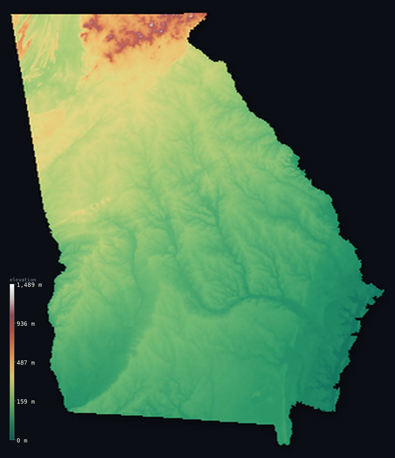
Georgia’s highest point is Brasstown Bald at 4,783 ft (1,458 m); its lowest is Atlantic Ocean at 0 ft (0 m); the mean elevation is 522 ft (159 m).
- Highest point📚
- 4,783 ft1,458 m
- Brasstown Bald.
- Lowest point📚
- 0 ft0 m
- Atlantic Ocean.
- Mean elevation⚙
- 522 ft159 m
- Computed from the GLO-30 surface model.
- Median elevation⚙
- 364 ft111 m
- Half of Georgia lies below this height.
- Elevation range📚
- 4,783 ft1,458 m
- From 0 m to Brasstown Bald's 1458 m.
- Above 1,000 m (3,281 ft)⚙
- <1%
- The state's main highlands.
- Official area📚
- 59,425 mi²153,910 km²
- Georgia.
Georgia at a glance
Georgia's Springer Mountain is the southern starting point of the 3,500 km Appalachian Trail.
source ↗The Okefenokee Swamp in the south is one of the largest intact freshwater wetlands in North America.
source ↗Brasstown Bald is high enough to catch snow and cloud while the rest of the state stays warm.
source ↗More than half of Georgia is low, flat coastal plain despite its mountainous north.
source ↗Georgia is the largest US state east of the Mississippi River by land area.
source ↗
Elevation profile of Georgia
The largest share of land, 45%, falls in the 0–100 m band, and 96% of the territory lies below 500 m (1,640 ft).
- below 500 m (1,640 ft)96%
- 500–1,000 m3%
- 1,000–2,000 m<1%
Highest and lowest points
The highest point of the US state of Georgia, Brasstown Bald, 1,458 m, a lone high summit in the Blue Ridge Mountains of the state's northern tip, often wrapped in cloud above the surrounding ridges.
source ↗Highest peaks of Georgia
| Peak | Elevation | Range | Note |
|---|---|---|---|
| Brasstown Bald↗ | 4,783 ft1,458 m | Blue Ridge Mountains | Highest point of the state of Georgia. |
| Rabun Bald↗ | 4,459 ft1,359 m | Blue Ridge Mountains | The second-highest peak in Georgia. |
| Blood Mountain↗ | 4,459 ft1,359 m | Blue Ridge Mountains | A famous peak on the Appalachian Trail in Georgia. |
| Cohutta Mountain↗ | 4,124 ft1,257 m | Cohutta Mountains | A high point of the northwestern Georgia mountains. |
| Springer Mountain↗ | 3,780 ft1,152 m | Blue Ridge Mountains | The southern terminus of the Appalachian Trail. |
Terrain regions of Georgia
Georgia's Springer Mountain is the southern starting point of the 3,500 km Appalachian Trail. ↗
The Blue Ridge Mountains
↗The northern tip of Georgia rises into the Blue Ridge Mountains, the southern end of the Appalachians, where Brasstown Bald (1,458 m) stands as the state's summ
The Piedmont
↗Most of northern and central Georgia is the Piedmont, a broad belt of red-clay hills and low ridges descending from the mountains, holding Atlanta and the fall
The coastal plain
↗Southern Georgia is a wide, flat coastal plain covering more than half the state - pine flatwoods, farmland and the great Okefenokee Swamp, sloping gently to th
The Blue Ridge Mountains
the northThe northern tip of Georgia rises into the Blue Ridge Mountains, the southern end of the Appalachians, where Brasstown Bald (1,458 m) stands as the state's summit. This is cool, forested high country, the source of Georgia's rivers and the start of the Appalachian Trail at Springer Mountain.
The Piedmont
the centreMost of northern and central Georgia is the Piedmont, a broad belt of red-clay hills and low ridges descending from the mountains, holding Atlanta and the fall line where rivers drop toward the coastal plain. It is the populous, rolling heart of the state.
The coastal plain
the southSouthern Georgia is a wide, flat coastal plain covering more than half the state - pine flatwoods, farmland and the great Okefenokee Swamp, sloping gently to the Atlantic coast and its low barrier islands, where the land meets the sea.
City elevations in Georgia
| City | Population | Elevation |
|---|---|---|
| Atlanta | 510,823 | 1,047 ft319 m |
| Columbus | 206,922 | 246 ft75 m |
| Savannah | 147,780 | 30 ft9 m |
| Athens | 127,315 | 738 ft225 m |
| Macon | 91,351 | 384 ft117 m |
| Albany | 74,843 | 210 ft64 m |
| Valdosta | 55,724 | 220 ft67 m |
| Augusta | 43,459 | 141 ft43 m |
| Gainesville | 38,712 | 1,250 ft381 m |
| Milton | 37,547 | 994 ft303 m |
Elevation sampled at each city centre from the Copernicus GLO-30 model. Cities and population from GeoNames (CC-BY 4.0).
Georgia in comparison
Georgia's terrain rises 4,783 ft (1,458 m) from sea level to Brasstown Bald — about 16% of the height of Mount Everest, the world's highest point at 29,032 ft (8,849 m).
Frequently asked questions
What is the highest point in Georgia?
- Brasstown Bald, 4,783 ft (1,458 m).
What is the average elevation of Georgia?
- About 180 m according to the USGS; this page also reports the area-weighted mean computed from the Copernicus GLO-30 model, 522 ft (159 m).
What is the lowest point in Georgia?
- Atlantic Ocean, 0 ft (0 m).
Georgia's Springer Mountain is the southern starting point of the 3,500 km Appalachian Trail?
- Georgia's Springer Mountain is the southern starting point of the 3,500 km Appalachian Trail.
Where is the highest ground in Georgia?
- The northern tip of Georgia rises into the Blue Ridge Mountains, the southern end of the Appalachians, where Brasstown Bald (1,458 m) stands as the state's summit. This is cool, forested high country,
Is this a topographic, relief, contour, or elevation map of Georgia?
- They describe the same thing - terrain height. This page renders Georgia's actual elevation surface in interactive 3D (a relief or topographic view) and reports the statistics computed from it; a contour map shows the same data as lines of equal height.
About this map
The terrain is rendered from the Copernicus GLO-30 digital elevation model (ESA), masked to the US-GA boundary from geoBoundaries (gbOpen). Elevation statistics are computed directly from the model; peak names and researched facts are sourced and cited. See the methodology for the full pipeline.
Our area-weighted mean, computed from the Copernicus GLO-30 model, is 522 ft (159 m); the figure commonly cited elsewhere is 591 ft (180 m) (U.S. Geological Survey). Georgia's mean elevation is about 180 m; the page reports the area-weighted figure computed from the Copernicus GLO-30 model.
Surveyed national figures: official area · high point.
Rendered from Copernicus GLO-30 (ESA, 2021 release), boundaries from geoBoundaries. Generated 2026-07-14.