South Carolina Elevation Map
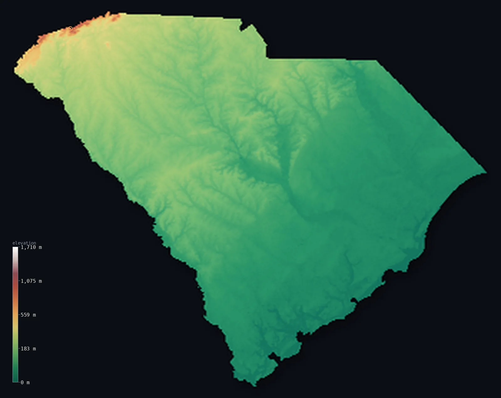
South Carolina’s highest point is Sassafras Mountain at 3,560 ft (1,085 m); its lowest is Atlantic Ocean at 0 ft (0 m); the mean elevation is 341 ft (104 m).
- Highest point📚
- 3,560 ft1,085 m
- Sassafras Mountain.
- Lowest point📚
- 0 ft0 m
- Atlantic Ocean.
- Mean elevation⚙
- 341 ft104 m
- Computed from the GLO-30 surface model.
- Median elevation⚙
- 233 ft71 m
- Half of South Carolina lies below this height.
- Elevation range📚
- 3,560 ft1,085 m
- From 0 m to Sassafras Mountain's 1085 m.
- Above 1,000 m (3,281 ft)⚙
- <1%
- The state's higher ground.
- Official area📚
- 32,021 mi²82,933 km²
- South Carolina.
South Carolina at a glance
Sassafras Mountain's summit tower straddles the South Carolina-North Carolina state line.
source ↗The Blue Ridge Escarpment in the northwest is one of the wettest places in the eastern US.
source ↗Two-thirds of South Carolina is flat coastal plain, the Lowcountry of marsh and sea islands.
source ↗The state falls from 1,085 m in the Blue Ridge to sea level in under 400 km.
source ↗The Lowcountry's sea islands were long isolated enough to preserve the distinct Gullah culture.
source ↗
Elevation profile of South Carolina
The largest share of land, 56%, falls in the 0–100 m band, and 99% of the territory lies below 500 m (1,640 ft).
- below 500 m (1,640 ft)99%
- 500–1,000 m1%
- 1,000–2,000 m<1%
Highest and lowest points
The highest point of South Carolina, Sassafras Mountain, 1,085 m, on the North Carolina border in the Blue Ridge - the state's only real mountain country, crowned by a lookout tower straddling the state line.
source ↗Sassafras Mountain is a border summit: its peak lies just outside the generalized South Carolina boundary, so the highest fully in-territory land pixel in the model is 3,530 ft (1,076 m). The headline figure above is the surveyed elevation of the recognised national high point.
Highest peaks of South Carolina
| Peak | Elevation | Range | Note |
|---|---|---|---|
| Sassafras Mountain↗ | 3,560 ft1,085 m | Blue Ridge Mountains | Highest point of South Carolina, on the NC line. |
| Pinnacle Mountain↗ | 3,301 ft1,006 m | Blue Ridge Mountains | The highest peak wholly within South Carolina. |
| Caesars Head↗ | 3,199 ft975 m | Blue Ridge Mountains | A high cliff-edge point of the Blue Ridge. |
| Table Rock↗ | 3,117 ft950 m | Blue Ridge Mountains | A dramatic granite dome of the Blue Ridge escarpment. |
| Rocky Bottom highpoint↗ | 2,953 ft900 m | Blue Ridge Mountains | High ground of the northwestern mountains. |
Terrain regions of South Carolina
Sassafras Mountain's summit tower straddles the South Carolina-North Carolina state line. ↗
The Blue Ridge
↗The far northwestern corner of South Carolina rises into the Blue Ridge Mountains - the state's only true mountain country, a small but rugged wedge of high pea
The Piedmont
↗The upper third of the state is the Piedmont, a belt of rolling red-clay hills descending southeast from the mountains to the fall line, where the rivers drop t
The coastal plain and Lowcountry
↗Two-thirds of South Carolina is flat coastal plain, sloping gently to the Atlantic - sandhills, pine forest and farmland giving way to the Lowcountry of tidal m
The Blue Ridge
the far northwestThe far northwestern corner of South Carolina rises into the Blue Ridge Mountains - the state's only true mountain country, a small but rugged wedge of high peaks and steep escarpments where Sassafras Mountain (1,085 m) tops the state on the North Carolina line, and waterfalls plunge off the Blue Ridge front.
The Piedmont
the upper stateThe upper third of the state is the Piedmont, a belt of rolling red-clay hills descending southeast from the mountains to the fall line, where the rivers drop toward the coastal plain. This is the higher, older interior around Greenville and the upstate.
The coastal plain and Lowcountry
the centre and coastTwo-thirds of South Carolina is flat coastal plain, sloping gently to the Atlantic - sandhills, pine forest and farmland giving way to the Lowcountry of tidal marsh, sea islands and the historic coast around Charleston, meeting the ocean at sea level.
City elevations in South Carolina
| City | Population | Elevation |
|---|---|---|
| Columbia | 142,416 | 308 ft94 m |
| Charleston | 132,609 | 26 ft8 m |
| Rock Hill | 71,548 | 682 ft208 m |
| Greenville | 64,579 | 984 ft300 m |
| Augusta | 43,459 | 141 ft43 m |
| Sumter | 40,816 | 177 ft54 m |
| Hilton Head Island | 40,512 | 46 ft14 m |
| Florence | 38,228 | 144 ft44 m |
| Spartanburg | 37,867 | 801 ft244 m |
| Myrtle Beach | 31,035 | 30 ft9 m |
Elevation sampled at each city centre from the Copernicus GLO-30 model. Cities and population from GeoNames (CC-BY 4.0).
South Carolina in comparison
South Carolina's terrain rises 3,560 ft (1,085 m) from sea level to Sassafras Mountain — about 12% of the height of Mount Everest, the world's highest point at 29,032 ft (8,849 m).
- Georgia's mean elevation is 4,045 ft — 3,704 ft higher; its high point, Shkhara, reaches 17,037 ft (5,193 m), 13,478 ft above. Georgia elevation map →
Frequently asked questions
What is the highest point in South Carolina?
- Sassafras Mountain, 3,560 ft (1,085 m).
What is the average elevation of South Carolina?
- About 110 m according to the USGS; this page also reports the area-weighted mean computed from the Copernicus GLO-30 model, 341 ft (104 m).
What is the lowest point in South Carolina?
- Atlantic Ocean, 0 ft (0 m).
Sassafras Mountain's summit tower straddles the South Carolina-North Carolina state line?
- Sassafras Mountain's summit tower straddles the South Carolina-North Carolina state line.
Where is the highest ground in South Carolina?
- The far northwestern corner of South Carolina rises into the Blue Ridge Mountains - the state's only true mountain country, a small but rugged wedge of high peaks and steep escarpments where Sassafras
Is this a topographic, relief, contour, or elevation map of South Carolina?
- They describe the same thing - terrain height. This page renders South Carolina's actual elevation surface in interactive 3D (a relief or topographic view) and reports the statistics computed from it; a contour map shows the same data as lines of equal height.
About this map
The terrain is rendered from the Copernicus GLO-30 digital elevation model (ESA), masked to the US-SC boundary from geoBoundaries (gbOpen). Elevation statistics are computed directly from the model; peak names and researched facts are sourced and cited. See the methodology for the full pipeline.
Our area-weighted mean, computed from the Copernicus GLO-30 model, is 341 ft (104 m); the figure commonly cited elsewhere is 361 ft (110 m) (U.S. Geological Survey). South Carolina's mean elevation is about 110 m; the page reports the area-weighted figure computed from the Copernicus GLO-30 model.
Surveyed national figures: official area · high point.
Rendered from Copernicus GLO-30 (ESA, 2021 release), boundaries from geoBoundaries. Generated 2026-07-14.