North Carolina Elevation Map
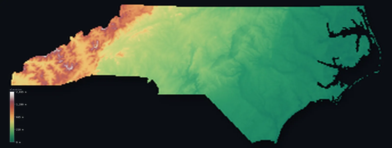
North Carolina’s highest point is Mount Mitchell at 6,683 ft (2,037 m); its lowest is Atlantic Ocean at 0 ft (0 m); the mean elevation is 771 ft (235 m).
- Highest point📚
- 6,683 ft2,037 m
- Mount Mitchell.
- Lowest point📚
- 0 ft0 m
- Atlantic Ocean.
- Mean elevation⚙
- 771 ft235 m
- Computed from the GLO-30 surface model.
- Median elevation⚙
- 358 ft109 m
- Half of North Carolina lies below this height.
- Elevation range📚
- 6,683 ft2,037 m
- From 0 m to Mount Mitchell's 2037 m.
- Above 1,000 m (3,281 ft)⚙
- 5%
- The state's main highlands.
- Official area📚
- 53,819 mi²139,391 km²
- North Carolina.
North Carolina at a glance
Mount Mitchell is the highest point in the United States east of the Mississippi River.
source ↗It is named for Elisha Mitchell, who died in 1857 while trying to prove its height.
source ↗The state falls almost 2,000 m from the Black Mountains to the Outer Banks in about 500 km.
source ↗The Black Mountains around Mount Mitchell hold the six highest peaks in the eastern United States.
source ↗Cape Hatteras on the Outer Banks marks where the cold Labrador Current meets the warm Gulf Stream, earning the name 'Graveyard of the Atlantic'.
source ↗
Elevation profile of North Carolina
The largest share of land, 63%, falls in the 0–200 m band, and 85% of the territory lies below 500 m (1,640 ft).
- below 500 m (1,640 ft)85%
- 500–1,000 m10%
- 1,000–2,000 m5%
Highest and lowest points
Highest peaks of North Carolina
| Peak | Elevation | Range | Note |
|---|---|---|---|
| Mount Mitchell↗ | 6,683 ft2,037 m | Black Mountains | Highest point of North Carolina and of eastern North America. |
| Clingmans Dome↗ | 6,644 ft2,025 m | Great Smoky Mountains | On the Tennessee border; among the highest in the Smokies. |
| Mount Craig↗ | 6,621 ft2,018 m | Black Mountains | The second-highest peak in the eastern US, beside Mitchell. |
| Roan High Knob↗ | 6,286 ft1,916 m | Roan Highlands | A high grassy-balded summit on the Tennessee border. |
| Grandfather Mountain↗ | 5,965 ft1,818 m | Blue Ridge | A rugged, well-known peak of the Blue Ridge. |
Terrain regions of North Carolina
Mount Mitchell is the highest point in the United States east of the Mississippi River. ↗
The Blue Ridge and western mountains
↗Western North Carolina holds the highest mountains in eastern North America - the Blue Ridge, the Great Smokies and the Black Mountains, where Mount Mitchell (2
The Piedmont
↗The centre of the state is the Piedmont, a broad belt of low hills and red clay soils descending eastward from the mountains - the most populous region, holding
The coastal plain and Outer Banks
↗Eastern North Carolina is a wide, flat coastal plain of farmland, swamp and pine, sloping gently to the Atlantic. It ends in the Outer Banks, a long chain of lo
The Blue Ridge and western mountains
the westWestern North Carolina holds the highest mountains in eastern North America - the Blue Ridge, the Great Smokies and the Black Mountains, where Mount Mitchell (2,037 m) rises higher than anything east of the Mississippi. Dozens of peaks top 1,800 m in this cool, forested high country.
The Piedmont
the centreThe centre of the state is the Piedmont, a broad belt of low hills and red clay soils descending eastward from the mountains - the most populous region, holding Charlotte, the Triad and the Research Triangle, crossed by rivers dropping toward the coastal plain.
The coastal plain and Outer Banks
the eastEastern North Carolina is a wide, flat coastal plain of farmland, swamp and pine, sloping gently to the Atlantic. It ends in the Outer Banks, a long chain of low barrier islands enclosing great sounds, where the land finally meets the sea at zero elevation.
City elevations in North Carolina
| City | Population | Elevation |
|---|---|---|
| Charlotte | 911,311 | 804 ft245 m |
| Raleigh | 482,295 | 318 ft97 m |
| Greensboro | 285,342 | 843 ft257 m |
| Fayetteville | 201,963 | 105 ft32 m |
| Wilmington | 115,933 | 46 ft14 m |
| Asheville | 95,056 | 2,149 ft655 m |
| Greenville | 90,597 | 62 ft19 m |
| Jacksonville | 67,357 | 16 ft5 m |
| Hickory | 40,374 | 1,161 ft354 m |
| Goldsboro | 35,826 | 112 ft34 m |
Elevation sampled at each city centre from the Copernicus GLO-30 model. Cities and population from GeoNames (CC-BY 4.0).
North Carolina in comparison
North Carolina's terrain rises 6,683 ft (2,037 m) from sea level to Mount Mitchell — about 23% of the height of Mount Everest, the world's highest point at 29,032 ft (8,849 m).
Frequently asked questions
What is the highest point in North Carolina?
- Mount Mitchell, 6,683 ft (2,037 m).
What is the average elevation of North Carolina?
- About 210 m according to the USGS; this page also reports the area-weighted mean computed from the Copernicus GLO-30 model, 771 ft (235 m).
What is the lowest point in North Carolina?
- Atlantic Ocean, 0 ft (0 m).
Mount Mitchell is the highest point in the United States east of the Mississippi River?
- Mount Mitchell is the highest point in the United States east of the Mississippi River.
Where is the highest ground in North Carolina?
- Western North Carolina holds the highest mountains in eastern North America - the Blue Ridge, the Great Smokies and the Black Mountains, where Mount Mitchell (2,037 m) rises higher than anything east
Is this a topographic, relief, contour, or elevation map of North Carolina?
- They describe the same thing - terrain height. This page renders North Carolina's actual elevation surface in interactive 3D (a relief or topographic view) and reports the statistics computed from it; a contour map shows the same data as lines of equal height.
About this map
The terrain is rendered from the Copernicus GLO-30 digital elevation model (ESA), masked to the US-NC boundary from geoBoundaries (gbOpen). Elevation statistics are computed directly from the model; peak names and researched facts are sourced and cited. See the methodology for the full pipeline.
Our area-weighted mean, computed from the Copernicus GLO-30 model, is 771 ft (235 m); the figure commonly cited elsewhere is 689 ft (210 m) (U.S. Geological Survey). North Carolina's mean elevation is about 210 m; the page reports the area-weighted figure computed from the Copernicus GLO-30 model.
Surveyed national figures: official area · high point.
Rendered from Copernicus GLO-30 (ESA, 2021 release), boundaries from geoBoundaries. Generated 2026-07-13.