Tennessee Elevation Map
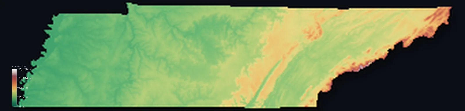
Tennessee’s highest point is Clingmans Dome at 6,644 ft (2,025 m); its lowest is Mississippi River at 177 ft (54 m); the mean elevation is 965 ft (294 m).
- Highest point📚
- 6,644 ft2,025 m
- Clingmans Dome.
- Lowest point📚
- 177 ft54 m
- Mississippi River.
- Mean elevation⚙
- 965 ft294 m
- Computed from the GLO-30 surface model.
- Median elevation⚙
- 827 ft252 m
- Half of Tennessee lies below this height.
- Elevation range📚
- 6,467 ft1,971 m
- From 54 m to Clingmans Dome's 2025 m.
- Above 1,000 m (3,281 ft)⚙
- 1%
- The state's main highlands.
- Official area📚
- 42,144 mi²109,153 km²
- Tennessee.
Tennessee at a glance
Clingmans Dome is the highest point on the entire 3,500 km Appalachian Trail.
source ↗The Great Smoky Mountains hold some of the most biologically diverse temperate forest on Earth.
source ↗Tennessee stretches through six distinct landform belts from the Smokies to the Mississippi.
source ↗Tennessee borders eight states - tied for the most of any state in the nation.
source ↗The Great Smoky Mountains are the most-visited national park in the United States.
source ↗
Elevation profile of Tennessee
The largest share of land, 43%, falls in the 200–400 m band, and 87% of the territory lies below 500 m (1,640 ft).
- below 500 m (1,640 ft)87%
- 500–1,000 m12%
- 1,000–2,000 m1%
Highest and lowest points
The highest point of Tennessee, Clingmans Dome, 2,025 m, on the North Carolina border in the Great Smoky Mountains - the highest point along the entire 3,500 km Appalachian Trail.
source ↗Clingmans Dome is a border summit: its peak lies just outside the generalized Tennessee boundary, so the highest fully in-territory land pixel in the model is 6,647 ft (2,026 m). The headline figure above is the surveyed elevation of the recognised national high point.
Highest peaks of Tennessee
| Peak | Elevation | Range | Note |
|---|---|---|---|
| Clingmans Dome↗ | 6,644 ft2,025 m | Great Smoky Mountains | Highest point of Tennessee and of the Appalachian Trail. |
| Mount Guyot↗ | 6,621 ft2,018 m | Great Smoky Mountains | The second-highest peak in the Smokies. |
| Mount Le Conte↗ | 6,594 ft2,010 m | Great Smoky Mountains | A famous Smokies peak rising high above Gatlinburg. |
| Roan High Knob↗ | 6,286 ft1,916 m | Roan Highlands | A high bald summit on the North Carolina border. |
| Big Frog Mountain↗ | 4,131 ft1,259 m | Blue Ridge | A high point of the southern Tennessee Blue Ridge. |
Terrain regions of Tennessee
Clingmans Dome is the highest point on the entire 3,500 km Appalachian Trail. ↗
The eastern mountains
↗Eastern Tennessee rises into the Blue Ridge and the Great Smoky Mountains along the North Carolina border - the highest, wettest part of the state, crowned by C
The Valley and Ridge and Cumberland Plateau
↗West of the mountains lies the long Great Valley of east Tennessee, a belt of parallel ridges and valleys holding Knoxville and Chattanooga, and beyond it the f
The central basin and western plain
↗Middle Tennessee is the rolling farmland of the Nashville Basin, ringed by the Highland Rim. West of the Tennessee River the land flattens into the Gulf Coastal
The eastern mountains
the eastEastern Tennessee rises into the Blue Ridge and the Great Smoky Mountains along the North Carolina border - the highest, wettest part of the state, crowned by Clingmans Dome (2,025 m) and cloaked in some of the richest temperate forest in North America.
The Valley and Ridge and Cumberland Plateau
the centre-eastWest of the mountains lies the long Great Valley of east Tennessee, a belt of parallel ridges and valleys holding Knoxville and Chattanooga, and beyond it the flat-topped Cumberland Plateau, a broad upland edged by steep escarpments.
The central basin and western plain
the centre and westMiddle Tennessee is the rolling farmland of the Nashville Basin, ringed by the Highland Rim. West of the Tennessee River the land flattens into the Gulf Coastal Plain, sloping down to the Mississippi River bluffs at Memphis - the state's lowest ground.
City elevations in Tennessee
| City | Population | Elevation |
|---|---|---|
| Nashville | 689,447 | 515 ft157 m |
| New South Memphis | 641,608 | 259 ft79 m |
| Knoxville | 190,740 | 919 ft280 m |
| Chattanooga | 181,099 | 692 ft211 m |
| Clarksville | 166,722 | 472 ft144 m |
| Jackson | 66,975 | 413 ft126 m |
| Johnson City | 66,027 | 1,637 ft499 m |
| Columbia | 36,800 | 653 ft199 m |
| Cookeville | 32,113 | 1,106 ft337 m |
| Morristown | 29,478 | 1,296 ft395 m |
Elevation sampled at each city centre from the Copernicus GLO-30 model. Cities and population from GeoNames (CC-BY 4.0).
Tennessee in comparison
Tennessee's terrain rises 6,467 ft (1,971 m) from Mississippi River (177 ft (54 m)) to Clingmans Dome — about 22% of the height of Mount Everest, the world's highest point at 29,032 ft (8,849 m).
Frequently asked questions
What is the highest point in Tennessee?
- Clingmans Dome, 6,644 ft (2,025 m).
What is the average elevation of Tennessee?
- About 270 m according to the USGS; this page also reports the area-weighted mean computed from the Copernicus GLO-30 model, 965 ft (294 m).
What is the lowest point in Tennessee?
- Mississippi River, 177 ft (54 m).
Clingmans Dome is the highest point on the entire 3,500 km Appalachian Trail?
- Clingmans Dome is the highest point on the entire 3,500 km Appalachian Trail.
Where is the highest ground in Tennessee?
- Eastern Tennessee rises into the Blue Ridge and the Great Smoky Mountains along the North Carolina border - the highest, wettest part of the state, crowned by Clingmans Dome (2,025 m) and cloaked in s
Is this a topographic, relief, contour, or elevation map of Tennessee?
- They describe the same thing - terrain height. This page renders Tennessee's actual elevation surface in interactive 3D (a relief or topographic view) and reports the statistics computed from it; a contour map shows the same data as lines of equal height.
About this map
The terrain is rendered from the Copernicus GLO-30 digital elevation model (ESA), masked to the US-TN boundary from geoBoundaries (gbOpen). Elevation statistics are computed directly from the model; peak names and researched facts are sourced and cited. See the methodology for the full pipeline.
Our area-weighted mean, computed from the Copernicus GLO-30 model, is 965 ft (294 m); the figure commonly cited elsewhere is 886 ft (270 m) (U.S. Geological Survey). Tennessee's mean elevation is about 270 m; the page reports the area-weighted figure computed from the Copernicus GLO-30 model.
Surveyed national figures: official area · high point.
Rendered from Copernicus GLO-30 (ESA, 2021 release), boundaries from geoBoundaries. Generated 2026-07-13.